World Dream Bank
home -
add a dream -
newest -
art gallery -
sampler -
dreams by
title,
subject,
author,
date,
places,
names
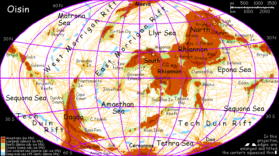
GAZETTEER OF OISIN
by Chris Wayan, 2005
dedicated to Poul Anderson for his remarkable world-building
Oisin homepage - Map - Rhiannon - Farside - Gazetteer - Terms explained - Nomenclature - More worlds? Planetocopia!
- FINDING ENTRIES: ignore words like "the" and "Cape"; Lake Fergus is under F.
- LARGE features are in CAPITALS.
- LONGITUDE on Oisin is always east, from 0 to 359. On the world map, 0 is in center, 90 center-right, 270 center-left, 180 at both edges.
- Lake Aengus, 12-22 N, 60 E
- a lake in central Rhiannon with extensive, fertile shallows that have diverged much from the rest of Oisin's life, since Aengus has been isolated for millions of years (though not as long as Lake Fergus to the northeast). The lake was a strait dividing North and South Rhiannon until the ebbing sea stranded it. Maponos Bay may be next; in the very long run, Aengus will probably sublimate entirely. (Source: God of youth and beauty; in Yeats, a wanderer who falls in love with a sort of naiad or were-fish)
- AMAETHAN SEA, 10 N to 60 S, 270-30 E
- the south-central sea above the southern tip of Morrigan Rift, with fertile shallows. (Source: Welsh god of agriculture; but other variants are Amadhan or Omadhaun the Fool, jester to the fairy court; a trickster figure with a cruel streak, something like Shakespeare's Puck: "what fools these mortals be".)
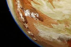
- Annwn Sea, 65-80 S, 180-300 E
- Far southern sea between Cerunnos and Dadga. Low sun and thick ice here block sunlight; little life under the ice. (Source: Welsh land of the dead.)
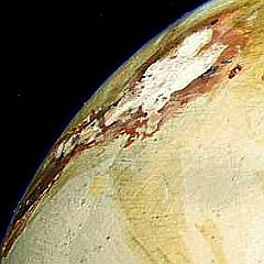
Right: Annwn Sea and Beare Peninsula
- Beare Peninsula, 60-65 S, 220-260 E
- A cape reaching west from far southern Dadga. Its shores are too dark for much surface life. (Source: associated with Don, god of the dead)
- Belenos Bay, Cape Belenos, 16-20 N, 95-115 E
- A rich reef community off southeast Rhiannon. As the sea's ebbed, the upper end of the long narrow bay has been cut off, leaving two large lakes, where species have begun diverging from those of the bay. (Source: god of sun, springs, and healing; the Celtic Apollo)
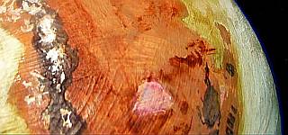
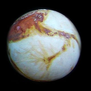
- Bran Crater, Lake Bran, 25-30 N, 20-25 E
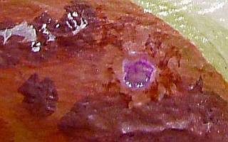
- Impact feature in South Rhiannon at the base of the Teutates Peninsula. The second largest visible crater on Oisin. The impact sterilized the region; the ice-covered lake filling it has only algae and unicellular life, seeded from elsewhere--probably a single rock from another impact. Its distinctive flamingo-pink patch is visible from space. (Source: legendary Celtic mariner)
Right: Lake Bran and the Finn Mts on Teutates Peninsula
- Brendan Isles, 10-15 N, 285 E
- An equatorial isle and reef community in the Matrona Sea; the focus of dozens of long ice-cracks. (Source: legendary saint and voyager, discoverer of islands, including, possibly, the New World)
- Brigantia Reefs, 8 N to 13 S, 225-255 E
- Extensive, fertile, equatorial reef system between the Sequona and Matrona Seas; the forked east end of the Brigid Rise. (Source: a name of the Great Goddess or a Celtic Athena/Minerva; see also Brigid, Sulis, Sulevia)
- BRIGID, 20-30 N, 165-195 E
- A large rugged island east of Rhiannon; heart of the long Brigid Rise, running from Rhiannon east nearly to Dagda. As sea levels drop, it will link to Rhiannon, becoming a third lobe of that supercontinent. Its shores support rich reef life. (Source: a name of the Great Goddess, later a saint; see also Sulis, Sulevia, Brigantia)
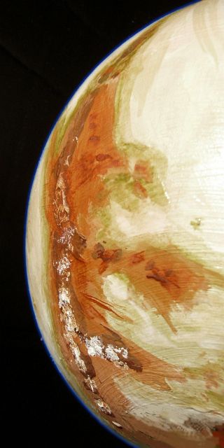
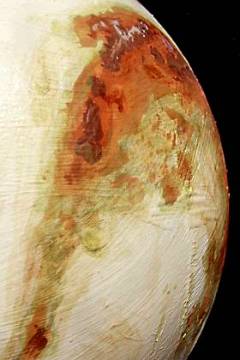
- Brigid Range, 35-65 N, 110-150 E
- High volcanic mountains (up to 6 km / 20,000') in eastern Rhiannon; the same range offshore forms the Isle of Brigid and the long Brigid Rise. (Source: a name of the Great Goddess, later a saint; see also Sulis, Sulevia, Brigantia)
Right: Isle of Brigid (lower left) and Brigid Range (center to upper right)
- Bull Island, 66-69 S, 272-302 E
- Far southern island, east of Cape Beare in southern Dagda. Too dark for much surface life. (Source: beneath this island lay the halls of the dead)
- CERNUNNOS, 68-90 S, 240-90 E
- The polar lobe of the southern continent, Dagda; too dark for much shore life, though the Tech Duin Rift runs not far offshore. (Source: God of the dance, the hunt, wild things; the Horned Man)
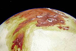
- DAGDA, 60 S, 210-280 E
- Two meanings:
- the south polar continent, only half the size of Australia
- The warmest, largest lobe of this continent, with its most fertile shores--a long wedge like an upside-down Patagonia poking at the equator (the Dagda Rise continues north, forming Nantosuelta, the Brendan Isles, Tir Nan Og and Maeve at the north pole).
(Source: chief god of the Irish)
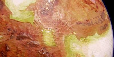
Right: Dagda. Emer Peninsula (top); Capes Neamh, Esus & Beare (center); subcontinent of Cernunnos (bottom)
- DAGDA RISE, 60 S to 90 N, 210-360 E
- This ridge runs almost pole to pole, at least 6500 km (4000 mi). It marks a plate boundary; in fact, the oceanic plates on BOTH sides of poor Dagda are spreading. In the south the big squeeze creates the continent of Dagda, which runs nearly from the pole to the equator before dipping underwater. But the Dagda Rise continues north, forming Nantosuelta, the Brendan Isles, Tir Nan Og and Maeve at the north pole. (Source: chief god of the Irish)
- DON, 54-75 S, 120-210 E
- Eastern lobe of Dagda, the far southern continent. Don's coast is too dark for much surface life. (Source: God of the dead)
- Deirdre Sound, 13-28 S, 260-270 E
- A fertile, triangular reef zone along the northwest coast of Dagda, the far southern continent. (Source: tragic figure in the Red Branch Cycle)
- Echraide, 0-5 N, 170 E
- Equatorial island in the Epona Sea; rich reef communities. (Source: Edain Echraide: Irish (male? female?) version of Epona, the horse goddess)
- Edain, 0-15 S, 135-160 E
- A long, slender tropical island, the southeast edge of the Epona Sea; rich reef communities. (Source: Edain Echraide: Irish (male? female?) version of Epona, the horse goddess)
- Emer Peninsula, 0-30 S, 260-275 E
- A triangular peninsula, the northern tip of Dagda, the far southern continent. Cape Emer's coasts are by far the most fertile part of Dagda, especially around Deirdre Sound.(Source: queen in the Red Branch Cycle; Cuchulain's wife)
- Epona Island, 13-35 S, 81-95 E
- large island due south of Rhiannon; the southwest edge of the Epona Sea. Rich reef communities along Epona's shores. (Source: British name for the horse goddess (hence our word 'pony'); see also Edain, Echraide, and Macha)
- EPONA SEA, 30 S to 35 N, 70-180 E
- equatorial sea southeast of Rhiannon; rich reef life, though few deep-sea vents. (Source: British name for the horse goddess)
Right: Isle of Epona (lower right) and Macha (upper right)
- Esus Peninsula, 45-60 S, 255-290 E
- cape in southeast Dagda; too dark for much surface life, except along its northwest shore. (Source: the Hanging Man, associated with bulls, cranes, trees and sacrifices)
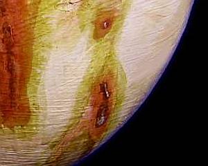
- Lake Fergus, 35-43 N, 95-100 E
- Lake in North Rhiannon, with extensive reef communities isolated for millions of years. Unique life forms, now stressed as the lake shrinks due to sublimation; doomed in the long run. Fergus's fate is a harbinger for all Oisin. (Source: Irish king in the Red Branch cycle)
- Finn Range, 30 N to 15 S, 0-70 E
- High mountains in southwestern Rhiannon; the same rise forms Cape Teutates and Innisfree. (Source: legendary hero of the Fenian Cycle)
Right: Lake Fergus (central pink shape); Grania Range (left)
- GOVANNON BAY, 18 N to 15 S, 330-22 E
- An arm of the Amaethan Sea, southwest of Rhiannon (at exact center of map). The shores support rich reef communities. (Source: god of smiths)
- Govannon Islands, 5-15 N, 340-12 E
- An archipelago of islets creating shallows all over northern Govannon Bay, extending nearly out to Innisfree, making the bay a biological hot spot. (Source: god of smiths)
- Grania Range, 15-50 N, 70-110 E
- A long curving range in central Rhiannon. They began as coastal mountains back when North and South Rhiannon were still separate. (Source: Finn's and Diarmuid's lover, in the Fenian Cycle)
- Innisfree, 5-10 S, 330 E
- An island southwest of Rhiannon, off Cape Teutates; a focus for extensive cracking. Rich reef communities in the wide shallows around it. As sea levels drop, Innisfree will grow and eventually link with Rhiannon. (Source: Yeats poem "The Lake Isle of Innisfree")
Right: Govannon Bay and Islands. Teutates Peninsula (top), Innisfree (lower left), Isle of Man (lower right)
- Isle of Man, 10-15 S, 10-15 E
- An island southeast of Rhiannon, supporting rich reef communities; a cracking center. (Source: variant of Manannan, the sea god?)
- LLYR SEA, 30-80 N, 345-120 E
- A deep sea north of Rhiannon. The East Morrigan Rift runs down its center, feeding at least 20% of Oisin's vent communities in the deeps. Llyr's south shore has fertile reefs, especially in Maponos Bay, but most shores have steep dropoffs or are too polar for much surface life. (Source: God of the deep sea; also a legendary mortal king. Spelled Lyr, Lir, and, famously, Lear.)
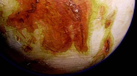
- Lugh Crater, Cape Lugh, 55 N, 135 E
- Impact feature in northeast Rhiannon, the largest visible on Oisin. Lugh is a double-walled basin 500 km wide (300 mi), with a central lake and arcuate lakes partly filling the outer ring. Presumably at the time of impact, the site was in shallow water, and flooded once it cooled. These lakes, now isolated for some millions of years, support unique species. Cape Lugh and Lugh Bay are small features on the coast just east of the crater, with rich but more conventional reefs. (Source: one-eyed god of music, craft, wisdom; the Celtic Wotan or Odin)
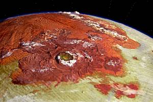 Right: Lugh Crater and Cape Lugh
- LYR, not on world map
- Oisin's primary--the giant world around which Oisin orbits in 5.3 days. While one side of Oisin always faces Lyr (the map centers on this face) Oisin does nod a bit (common among moons with elliptical orbits), so there's still significant tidal stress from Lyr as well as from the sun, massaging the mantle and stimulating active tectonics. Lyr also moderates temperatures on the inner face: Lyr-light at night is brilliant and includes infrared, while 72-minute noontime eclipses of the sun break the 63.5-hour daytime into two 31-hour days. Also, it may not be coincidence that Oisin's "land" hemisphere faces Lyr, just as Luna's "seas" face Earth. (Source: God of the deep sea; also a legendary mortal king. Also spelled Llyr, Lyr, Lir, and, famously, Lear.)
- Macha, 3-8 S, 75-83 E
- Equatorial island off southeast Rhiannon, north of Epona; rich reef communities. (Source: an Irish name for Epona, the horse goddess and queen of heaven?)
- MAEVE, 65-90 N, 310-90 E
- North polar continent about the size of Greenland, and looking much like it--about half is iced over. Some of this ice may be frozen CO2. Maeve is the northern end of the Dagda Rise. Its coasts are too dark for much surface life, though the Morrigan Rift curls round its shores, feeding nearly half of Oisin's deep-sea vent communities. (Source: Queen of the Sidhe (fairies); also spelled Mab, Medb, etc.)
Right: Maeve (center) with Tir Nan Og Peninsula (lower left). Water ice or dry ice?
- Cape Maia, 35-40 N, 120-140 E
- A peninsula east of Rhiannon; the west end of the Brigid Rise. Extensive reef communities, especially along its south shore in the shallow Maia Sea. (Source: Goddess, Lugh's wife, "The Provider"; goddess of bounty and fertility?)
- Maia Sea, 20-38 N, 105-145 E
- A small sea east of Rhiannon, south of Cape Maia and north of Cape Belenos. Shallow continental slopes support wide, rich reef communities. (Source: Goddess, Lugh's wife, "The Provider"; goddess of bounty and fertility?)
- Man, 10-15 S, 10-15 E
- An island southeast of Rhiannon, supporting rich reef communities; a cracking center. (Source: variant of Manannan, the sea god?)
- MANANNAN, not on map
- A second moon (like Oisin) orbiting huge Lyr. Manannan is the size of Pluto, and much denser, so it not only sheds light on Oisin's outer face at night, it adds tidal stress, warming Oisin's interior, stimulating active tectonics. (Source: the sea god, responsible for shallower waters than Lyr (see).)
- Maponos Bay, 22-30 N, 30-45 E
- A shallow bay on the north-central coast of Rhiannon, full of reef life. Once part of a strait dividing South and North Rhiannon; as the sea ebbs, it will probably become a cut-off lake like Aengus to the east, where new species evolve. Eventually it will dry up entirely. (Source: God of youth, a French Celtic version of Aengus?)
- MATRONA SEA, 0-90 N, 160-300 E
- A northern ocean, north of the Brigid Rise; the West Morrigan Rift winds down its center, supporting vent communities. Surface life centers on Sule Skerry. (Source: A mother goddess of the French Celts; goddess of the River Marne.)
- MORRIGAN RIFT, 80 N to 33 S, 300-270 E
- The northern mid-sea rift (spreading zone) feeding nearly half of Oisin's deep-sea vent communities. Curling around the pole, the rift has two limbs, east and west, in the Llyr Sea and Matrona Sea respectively. (Source: Goddess of death and rebirth, crows, and darkness)
Right: Maponos Bay (upper left) and Ogmios Bay (lower right) with Lake Aengus between.
- Nantosuelta Islands, 0-10 S, 275-280 E
- Island group about 600 km long off the northern tip of Dagda, the southern continent. Fertile reefs surround the Nantosueltas, stretching north to the Brendan Is. and south to Deirdre Sound. (Source: a French Celtic goddess of motherhood? Uncertain. Wife of Sucellus. See also Sulis, Brigid)
- Cape Niamh, Niamh Bay, 40-50 S, 270-280 E
- A cape on the east coast of Dagda. Niamh Bay lies just south of it, and north of the Esus Peninsula. Cape and bay are the southern end of the fertile reef zone; Esus and points south are too dark for much surface life. (Source: daughter of the god Aengus, and Oisin's lover)
- Ogmios Bay, 0-12 N, 70-80 E
- A bay off southeast Rhiannon; a rich reef community. Once the south end of the strait dividing South and North Rhiannon. (Source: God of writing, inventor of the ogham alphabet; an old man with a club.)
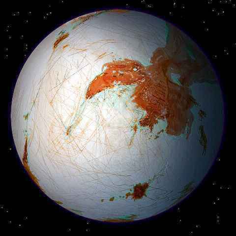
- OISIN
- The largest moon of Lyr, a world with 7 times the mass of Earth. Oisin is as big as Mercury or Titan, with a thin oxygen-nitrogen atmosphere and iced-over seas--more like ancient Snowball Earth than Europa. (Source: The archetypal wandering bard; variants include Ossian.)
- RHIANNON, 68 N to 19 S, 240-150 E
- Largest continent on Oisin, as big as Australia. Slender-waisted Rhiannon was once two continents, but as the sea ebbed, the strait between South and North Rhiannon broke up into Ogmios Bay, Lake Aengus, and Maponos Bay. While Rhiannon's shores and a few of its lakes support extensive "surface" life (below the ice skin), the land itself is a thin-aired Martian desert, with only subterranean life, mostly unicellular. (Source: Celtic version of the Great Goddess; emblem: horses, especially mares. The name means "Divine Queen." Aspects include Epona, Edain Echraide, and possibly Macha.)
- ROAN INISH, 37-52 S, 0-32 E
- A large island southwest of Rhiannon. A long reef system extends northeast, the Teirnan Reefs. As sea levels drop, Roan Inish will likely grow into a continent. (Source: abode of selkies (were-seals who marry humankind). From John Sayles's film "The Secret of Roan Inish." Literally just "Seal Island.")
- Rosmerta Islands, 31-37 N, 140-152 E
- Rosmerta and its satellites lie just off Cape Maia in eastern Rhiannon. Like Cape Maia, they form part of the Brigid Rise, and support large reef communities, especially off the south shores. (Source: a French Celtic variant of Maia, Lugh's wife, "The Provider"; goddess of bounty and fertility?)
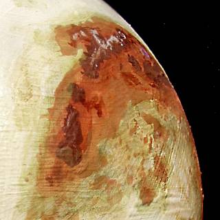
Right: Oisin's far side; East Rhiannon (upper left), Sequona Sea (lower half), Rosmerta Is. (just off Rhiannon's coast)
- SEQUONA SEA, 15 N to 56 S, 90-270 E
- A large southern sea, west of Dagda, south of the Brigid Rise. Most of its surface life is in the Brigantia Reefs and along the northern coast of Dagda. The south is too dark for much surface life, but the Tech Duin Rift winds along the sea-floor, supporting large vent communities. (Source: A goddess of the French Celts; spirit of the River Seine)
- Sucellus Bay, 5-15 S, 25-40 E
- A shallow bay dotted with islands off South Rhiannon. Fertile reefs. As the sea ebbs, Sucellus will become a lake. (Source: Celtic Bacchus; also a father figure; male counterpart to Sulis, goddess of motherhood? Emblems include cauldron/vat, a hammer (Thor?), and club/staff/phallos.)
- Sucellus Islands, 10-20 S, 25-40 E
- Islands off south Rhiannon. Too ill-defined to be called an island arc, but the rise will eventually cut off Sucellus Bay, turning it into a lake. Already, rich reefs extend 1000 km off the mainland. (Source: Celtic Bacchus; also a father figure; male counterpart to Sulis, goddess of motherhood? Emblems include cauldron, hammer, and club/staff.)
- Sulevia, 6-13 N, 213-225 E
- An island helping divide the Sequona and Matrona Sea. Part of the Brigid Rise; as the sea ebbs, Sulevia will eventually link to Sulis and Brigid to the northwest. Large, rich reefs, especially off its near-equatorial south shore.(Source: a celtic Athena; martial, but also a goddess of learning and healing; see also Sulis, Brigid, Brigantia)
Right: Sucellus Bay and Islands (left) and Taranis Bay (right)
- Sule Skerry, 40-45 N, 220-230 E
- A small archipelago and extensive reef system deep in the Matrona Sea; the focus of dozens of long ice-cracks. An oasis of surface life in this otherwise impoverished sea. (Source: Celtic version of Ultima Thule, the uttermost isle, abode of the Great Selkie (were-seal))
- Sulis, 15-20 N, 200-215 E
- An island helping divide the Sequona and Matrona Sea. Part of the Brigid Rise; as the sea ebbs, Sulevia will eventually fuse with Sulevia and Brigid. Large, rich reefs, especially the shallow straits to Brigid. (Source: a goddess of motherhood? Female aspect of Sucellus. Emblem: the cauldron? But may also be a variant of Sulevia, the celtic Athena, goddess of learning; see also Brigid, Brigantia)
- Taranis Bay, 12-20 S, 60 E
- A fertile bay in far southern Rhiannon. The valley continues inland, cupping two oval lakes with life diverging steadily from that of the Tethra Sea. (Source: French Celtic god, attributes uncertain)
- Taranis Peninsula, 8-20 S, 60-68 E
- The southern tip of Rhiannon, with large reef communities off its east and west shores. The cape ends in cliffs dropping into the frozen sea, but its rise may reappear as the Teirnon Reefs and Roan Inish. (Source: French Celtic god, attributes uncertain)
- TECH DUIN RIFT, 28-65 S, 0-235 E
- The southern mid-sea rift (spreading zone) feeding nearly half of Oisin's deep-sea vent communities. The rift winds east-west through the Tethra and Sequona Seas. (Source: dark undersea halls of the dead; the realm of Don.)
- Teirnon Reefs, 28-36 S, 30-50 E
- An extensive, fertile reef system northeast of Roan Inish, reaching almost to Rhiannon. As sea levels drop, Teirnon and Roan Inish may fuse into a new continent. (Source: a Welsh god, the "Divine Lord"; related to Irish Dagda and French Celtic Sucellos.)
- TETHRA SEA, 25-80 S, 0-120 E
- The sea south of central Rhiannon; its northern end around Epona and Roan Inish has fertile reefs such as Teirnon, but the south is too dark for much surface life. Tech Duin Rift crosses its floor, supporting some deep vent communities.(Source: A god or goddess of the deep sea; mother or father of Llyr?)
- TEUTATES PENINSULA, 13-32 N, 340-20 E
- The western end of Rhiannon, north of Govannan Bay. Its coasts support rich reef communities, especially on the south, around the Govannan Islands. (Source: French or British Celtic god; attributes uncertain.)
Right: Teutates Peninsula (center) and Govannon Isles (bottom)
- Tir Nan Og, 43-57 N, 300-320 E
- A large island with extensive reef communities, in the Matrona Sea; the focus of dozens of long ice-cracks. (Source: "Land of Youth", the celtic Paradise, located on isles far to the west; the Summer Isles.)
 GEOLOGICAL AND GEOGRAPHICAL TERMS EXPLAINED
- COMMUNITY
- Oisin has only five ecological zones; the life-web in each is called a community:
- the underground community (sparse life, limited to microbes on land)
- the deepsea community (sparse free-swimming or drifting life in the dark, open seas, below the light)
- the vent community (bizarre chemical-feeding life around hot, deep mineral vents; rich but spotty)
- the reef community (the richest, but found only where the sea bottom is shallow enough for sunlight)
- the skin community (life based on photosynthesis, just below the ice in open ocean).
- CRACKS, CRACKING CENTERS
- land, especially lone islands rising where subsurface currents are strong, promote extensive radial cracking of the sea's ice skin. These wounds seal immediately with relatively smooth ice (though often stained by bacteria and salts). Not as rich a niche as reefs, but many species are only found near cracks.
- CRATER
- Always an impact crater. Not as common on Oisin as you'd expect, though there are presently two over 100 km wide. But compare this to Luna or Mars, in the same size range, and you'll see how active Oisin is.
- DEEPSEA COMMUNITY
- life in mid-ocean; excludes sub-surface life (skin community) and the sea-floor life feeding on the minerals vented along rift zones (vent community).
- EBB
- This doesn't refer to Oisin's solar tides, but to the slow, eons-long drop in sea levels, due to atmospheric loss of water vapor, and the buildup of polar caps.
- LIGHT STARVATION
- All seas on Oisin are ice-covered, like our Arctic Sea. But the thickness varies, from a few yards at the equator to as much as ten or twenty at the poles. This doubly cuts the sunlight reaching below the ice--it's entering at a low angle, AND it must penetrate further. This severely limits photosynthesis and life-webs beyond about 50 north or south.
- LITLIFE
- Shorthand term for bio-communities on Oisin that feed on sunlight, lying just under the ice skin, as opposed to underground life or sea life below the light, whether free-swimming or on the bottom: NIGHTLIFE.
- NIGHTLIFE
- No, not dance clubs under the ice. I wish. This is a misleading shorthand term for all life too deep in the sea for the sun to reach, plus underground life. Opposite: LITLIFE.
- NUTRIENT PLUMES
- Sea life has few places to access minerals, since ice seals the surface from wind-blown dust and no rivers dump sediment--too cold for rivers, and little weather to erode the land anyway. The main nutrient sources are underwater volcanoes and rift vents, and a few coastal glaciers dropping rock flour into bays. Currents spread these into long swirling plumes of relative fertility.
- REEF COMMUNITY
- the most exuberant (and Earthlike) ecology on Oisin, in shallows where light reaches the sea bottom. Nowhere else on Oisin does life have light AND liquid water AND minerals; the result is a profusion like Earth's coral reefs.

- RIFT
- A spreading zone of crust, usually visible as winding twin ridges; the groove often has hot springs, or small volcanoes nearby. All Oisin's active rifts are undersea now, though this isn't always true.
- SKIN COMMUNITY
- life in the open ocean based on photosynthetic algae and plankton just below the ice, as distinguished from reef/coastal life or deep-sea life.
- "SURFACE" LIFE
- A misleading term: see the proper term, LITLIFE.
- UNDERGROUND COMMUNITY
- The populations of small organisms, mostly bacteria, living underground on land; the only land life on Oisin.
- VENT COMMUNITY
- life feeding on chemical energy around hot, deep mineral vents along deep-sea rifts; much like Terran vent communities--a mix of mobile and rooted species, mostly blind. Small, but rich.
- VOLCANOES
- Given Oisin's icy look you may think I mean ice volcanoes spewing water "lava", as suspected on Titan and other ice moons, but I mean the real thing; while Oisin always faces its huge primary Lyr, the sun and Manannan (Lyr's second large moon, the size of Pluto) heat the mantle with their tidal tugs. And Oisin's a big moon, as big as Mercury; it holds its heat. While all volcanoes on land are currently dormant, their cones attest that eruptions happen; indeed, undersea volcanoes may be erupting now.
NOMENCLATURE
Originally, I planned to use Celtic nomenclature for the world of Lyr (Oisin's huge primary), especially sea-gods and goddesses. But the records of Celtic myth are chaotic and fragmentary, disagreeing on even the major gods' names and natures. The Romans and Christians wrote what little we have, and they were hostile (to put it mildly). I found less than a hundred Celtic names, not nearly enough for a giant world like Lyr. But for Oisin, that was enough, so I've used them here.
Since the mythological records are so hazy and conflicting, I couldn't be clever about naming conventions (say, sea-gods for seas, goddesses for lakes, war gods and heroes for volcanoes, etc.) Nothing so specific! Seas are figures at least associated with water, but some are river-spirits; some island-names are mythical islands, but many aren't; places around the lifeless poles are named for gods and places associated with death and the underworld; and I tried to name tropical, living regions for gods linked to light and life... but that's about all.
 Oisin homepage - Map - Rhiannon - Farside - Gazetteer - Terms explained - Nomenclature - More worlds? Planetocopia!
World Dream Bank homepage - Art gallery - New stuff - Introductory sampler, best dreams, best art - On dreamwork - Books
Indexes: Subject - Author - Date - Names - Places - Art media/styles
Titles: A - B - C - D - E - F - G - H - IJ - KL - M - NO - PQ - R - Sa-Sk - Sl-Sz - T - UV - WXYZ
Email: wdreamb@yahoo.com - Catalog of art, books, CDs - Behind the Curtain: FAQs, bio, site map - Kindred sites