XANADU: Fensal and Aztlan Seas
by Chris Wayan, 2006
STILL UNDER CONSTRUCTION
to Joan Vinge, for "Eyes of Amber", set on a living Titan
Xanadu: main page - map - regional tours - (don't click yet) peoples of Xanadu - (don't click yet) Xanadu's evolution - more worlds: Planetocopia
INTRODUCTION
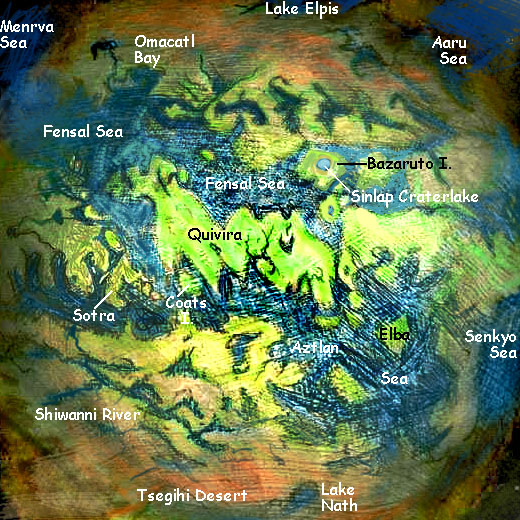
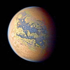
This is a test page for a regional tour. The photo to the left is a tweaked version of Titan, showing the dark "sea" basins called Fensal and Aztlan, with lighter Quivira like a long island dividing them. To the south are the complex river canyons of the Shiwanni Virgae; the surrounding lighter (high?)lands are called Tsegihi. The mysterious white arc called the Hotei Arcus is a U-shape near the horizon at left. A mountain-arc with methane snow?
The sketch map below shows the region in more detail. It's poor quality of course; so is the original Titan data! And this is one of the better-photographed regions on Titan; for much of the surface we still have much hazier images.
The names, like all on Xanadu, come from Titan, where a dark but apparently dry basin with exactly the same names and appearance lies at the same latitude and longitude. Curious coincidence!
This introduction will be a brief overview of the region--right now, all I know is that the sea is equatorial and one of the three largest on Xanadu. Given the planet's atmospheric circulation patterns, I can project that it'll generate more rain than most of Xanadu gets--ethane rain, not water, but still, rain; if life on the planet is based on ethane instead of water, the shores should be as fertile as it gets on Xanadu.
But further details haven't been worked out yet; the text below is just a placeholder--
ECOLOGY
Since Xanadu is a bigger, warmer, "wetter" version of Titan, we don't have to be as cautious about interpretation as scientists were (and rightly so) about Titan. Xanadu's dark lines and patches are true ethane rivers and seas; the faculae or light spots are islands. The huge one in the center is Quivira; north of it lies the Fensal Sea, south of it, the Aztlan Sea. I picked this region partly because a decent space photo of the equivalent region on Titan was available, but partly because of all that water--oops, ethane. Given Xanadu's rotation, temperature and so on, I expect Quivira and the surrounding coasts and islands to be one of the garden spots of Xanadu--warm, rainy and lush on land, and sounds full of flourishing coral reefs. Warm, of course, is a relative term; a Terran would freeze in seconds.
I've added the local names (where there are any, yet; Titan nomenclature is still very spotty) and colored the land to green to brown to suggest its climate and vegetation. Some very hasty assumptions there!
Oh, well--these ARE maps, not tweaked space photos, so the colors are arbitrary and designed for Earth eyes. They do at least point out the three main zones: deserts, land with ground cover, and lakes/seas.
A few patterns are already obvious. As on all worlds where sunlight reaches the ground, Xanadu's equatorial belt warms up more than higher latitudes. Hot air absorbs more moisture (though in this case it's a weird brew of hydrocarbons, not water). As it rises and cools, a rainy belt is created; you'll notice that Quivira (straddling the equator) and the surrounding islands are quite green; but beyond the northern shore of the Fensal Ocean and the south shore of Aztlan, the land grows steadily drier. Only in lowlands has ethane collected: the Aaru Sea, Lake Elpis, the Menrva Sea. Away from the equator, land life will concentrate in the locally wetter conditions along their shores, and up the many long river valleys visible from space. Past 50 or 60 north and south, the polar regions appear to be wetter again; at least, more large lakes appear, if not a full-size sea.
CIVILIZATION
I've only talked of land life. What of sea life, dear human readers? Don't forget you're biased. Most of the big-brained species on Earth (as the naked apes parochially call it) are aquatic. Whales, dolphins and orcas, pinnipeds, dugongs and manatees, sea otters, octopi and squid... It's just hands and fire that are hard to come by in the sea--not brains or language. And on Xanadu the land may have few advantages over the sea for civilization. The atmosphere is mildly reducing, not strongly oxidizing; there may be no easy equivalent of fire to discover. Earth's oceans are huge and mostly barren--there's little to manipulate, and long distances to travel, so it's no wonder most species sacrifice dexterity for streamlining. But Xanadu's seas are shallow and nearly all coastal, where rivers can feed them nutrients; they'll be relatively rich, more like our coral reefs and kelp forests. Agile and dexterous creatures like our sea otters and octopi may have the advantage here, not marathon swimmers like whales.
While big-brained creatures in this ecozone might never get out of the stone age, are we sure anyone on Xanadu will? And do we care about their technology anyway? Any technology inferior to our own is of merely cultural interest; technology beyond ours is nearly impossible to speculate on (if I could do so, I'd build and patent that instead of building planets--nobody really funds the arts these days. Ask Slartibartfast. Oh, they'll give you an award for a nice coastline now and then, but can you take that to the bank?). So technological speculation is pointless; isn't it really culture--alien viewpoints--that we're interested in?
Marine reef-cultures may be primarily oral, since on a coral reef, written records (and absolutely everything else not swimming around, and even some things that do) tend to get encrusted and eventually covered up. So perhaps we may expect more historical depth from land cultures. But that's a minor advantage; think of the sophistication of oral societies around the world--the vibrant Incan theatre, Polynesian dance, the sculpture and masked drama of British Columbia, the music of Africa, the dream-techniques of Siberian shamans (let's skip the huge topic of food: ethane-based cuisine will NOT be the next restaurant craze. Mmm, exploding entrees!)
Readers (yeah, you, but not just you! I mean people who read) tend to underestimate the accuracy and longevity of oral history. Some Australian natives know their ancestry fifty generations back. Do you? And the tribes around Crater Lake have folk tales describing the catastrophe that created it in considerable detail... eight thousand years ago.
So let's not jump to conclusions about the center of gravity of Xanadu's civilization(s). At the very least, we should pay as much attention to coastal waters as to the lands adjoining them. Though the great river-valleys are a third legitimate place to watch...
MAP NOTE
Sorry the maps are so rough. I don't want to draw clear, definitive regional maps of Xanadu until Titan itself is reasonably well mapped and named--though at the rate that's happening, it may only take another year or two to get where it took three centuries with Mars.
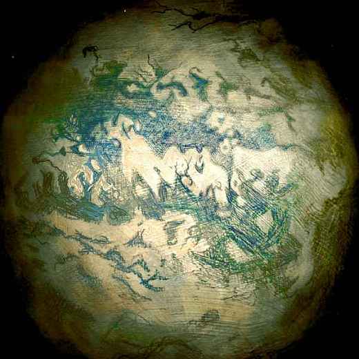
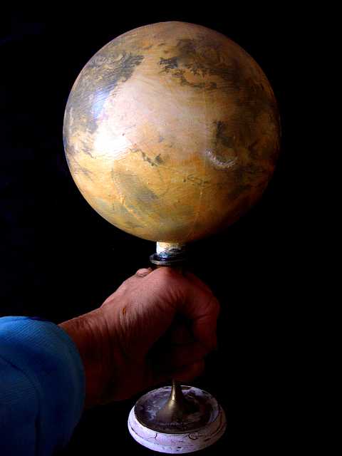
In case you're curious, the sketchmap is a scan (not a photo) of a small globe of Titan--really a big plastic Christmas-tree ornament I glued onto a candlestick, primed with acrylic, and drew on in pencil. It's 13 cm in diameter (just over 5"), roughly correct for Titan next to my 31 cm (12") globe of Earth. Crude and low-resolution of course, but about as good a map of Titan as anyone has right now; and if I update it as data comes in, eventually I'll have a fairly accurate model of Titan from space. In the end, I expect to use it to fake low-orbital photos of Xanadu's regions.
But not this year. Not while the Belet Ocean hemisphere is practically unknown, and the north is still blank. Anything could be hiding in the haze up there.
--Chris Wayan, 2006
THREE YEARS LATER
Well, now it's early 2010, and the north pole is wet. Huge lakes if not true seas. Looks like I'll have to take Xanadu out of (ahem) cold storage...
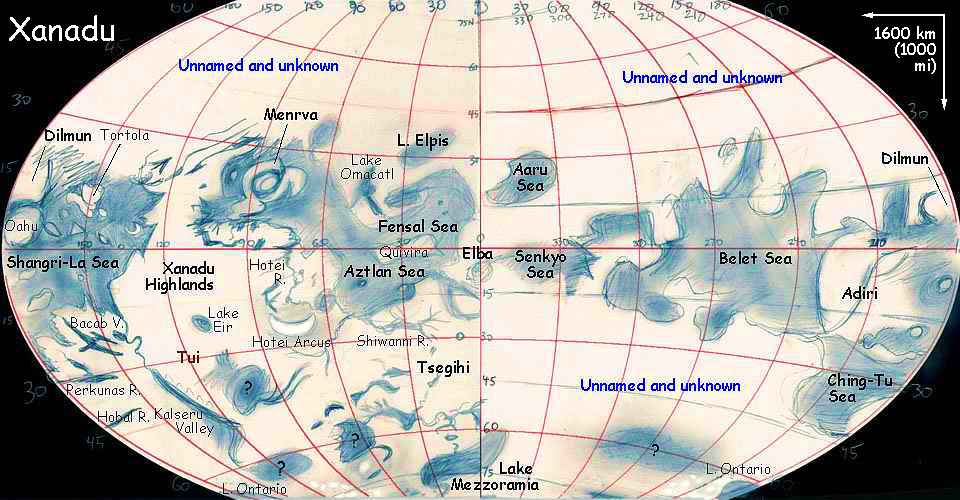
UNDER CONSTRUCTION! Only boldfaced names work yet! Shangri-La Ocean -- Perkunas, Bacab and Hobal Valleys -- Lake Ontario -- Adiri and the Ching-Tu Sea -- Belet Ocean -- Senkyo Sea, Lake Aaru -- Tsegihi and Lake Mezzoramia -- the Fensal & Aztlan Seas -- Menrva Ring -- Xanadu Highland, Lake Eir and the Hotei Arcus -- Tui and Kalseru Valley --
Xanadu's homepage - (don't click yet) peoples of Xanadu - (don't click yet) Xanadu's evolution - (don't click yet) Gazetteer - More worlds: Planetocopia
World Dream Bank homepage - Art gallery - New stuff - Introductory sampler, best dreams, best art - On dreamwork - Books
Indexes: Subject - Author - Date - Names - Places - Art media/styles
Titles: A - B - C - D - E - F - G - H - IJ - KL - M - NO - PQ - R - Sa-Sk - Sl-Sz - T - UV - WXYZ
Email: wdreamb@yahoo.com - Catalog of art, books, CDs - Behind the Curtain: FAQs, bio, site map - Kindred sites