Abyssia: Andean Islands

by Chris Wayan, 2007
for Aubergine the Dodo, and her kin
Abyssia home - down to map - building Abyssia - geology & geography - critters & cultures - the clash of names - more worlds? Planetocopia!
Abyssia: Andean Islands
by Chris Wayan, 2007
for Aubergine the Dodo, and her kin
Abyssia home - down to map - building Abyssia - geology & geography - critters & cultures - the clash of names - more worlds? Planetocopia!
Introduction - Western Isles - Cities - Chilea - Tsunamis - Biology
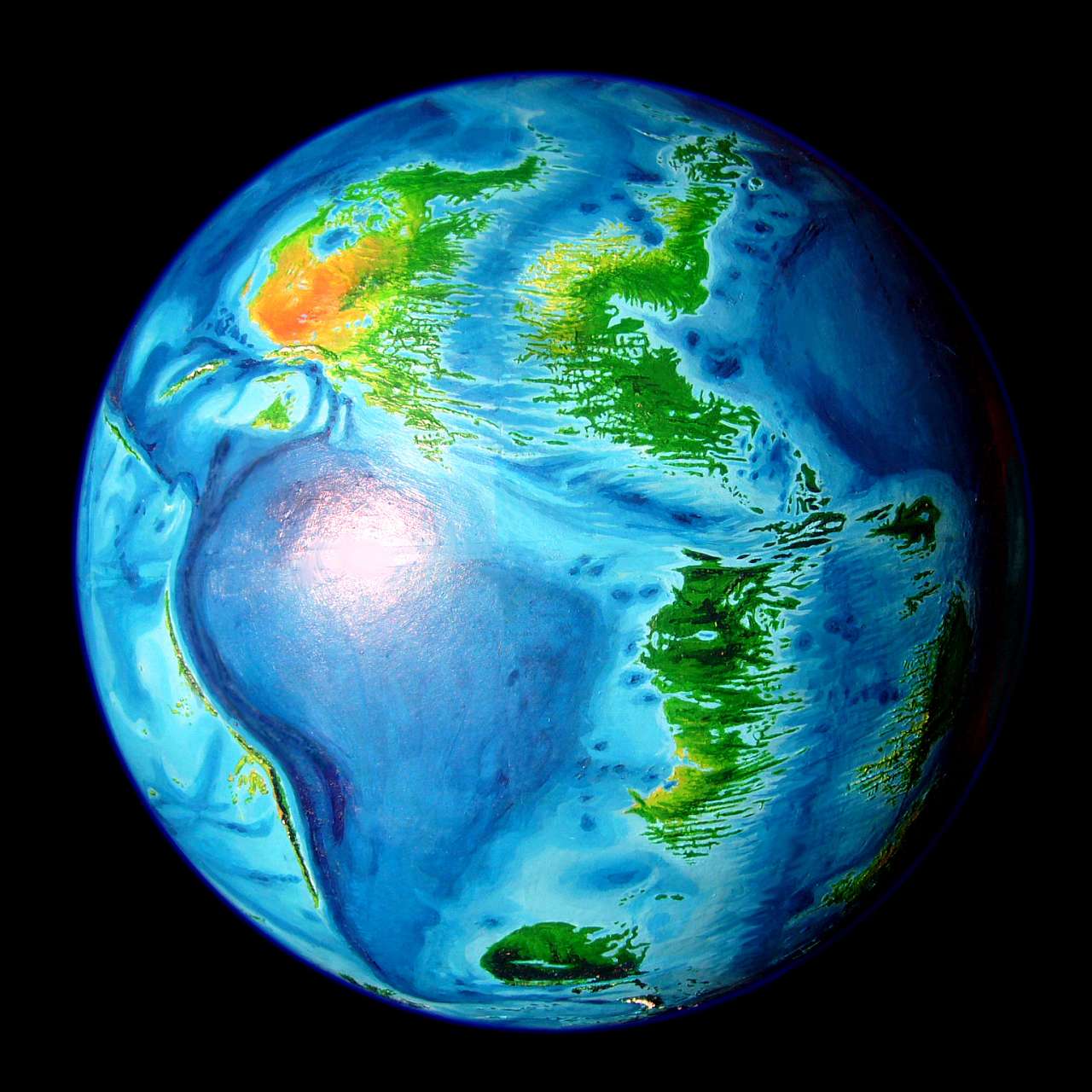
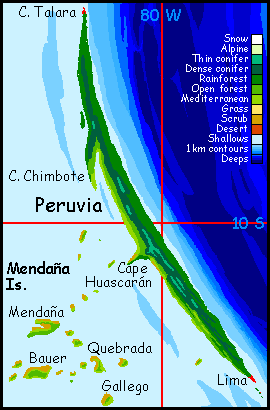
The Andean Islands are a long sliver of land, essentially a single ridge with a few interruptions and satellites, rising west of the Andean Deep. They're the upside-down equivalent of our Peru-Chile Trench. The main islands run north to south. The two largest, by far, are tropical Peruvia in the north, some 900 km long (560 mi), and Mediterranean Chilea in the south, a good 2200 km long (1400 mi). Both are quite narrow, never more than 120 km wide, and often less than 50 (75-30 mi), yet because they're so long, the total area rivals that of Japan.
Since storms can blow in from two oceans, the climate's rainier than our South America's west coast; more like the Philippines or Taiwan than Chile. But there are exceptions, as we'll see.
UNCERTAINTY
Peruvia and Chilea have fairly clear coastlines, sizes and topographies--it's hard to misplace such a huge trench!--but the lesser islands to the west are low, and thus much harder to chart. They exist, and the major isles will be where I say, but their coastlines are guesses.
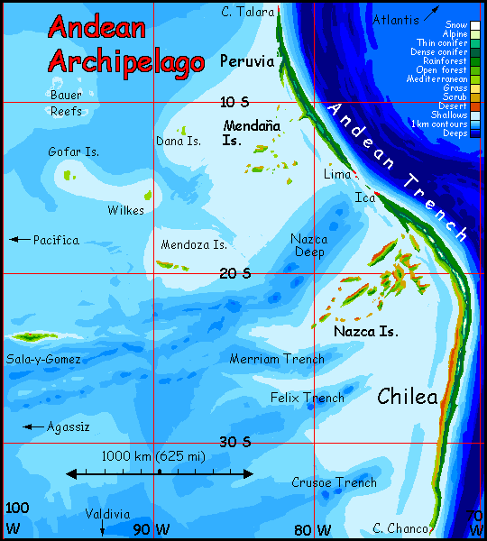
The farthest out, Sala, is the most uncertain because its my sources disagree on both depth and location of the corresponding trough in our world. I originally drew it around 23°S, 95° W; but two of my atlases put Sala farther out, around 24°S and 99°W, (as in the revised map to right). But several more sources show no trough deep enough to form an Abyssian island at all--though they lack enough detail for me to trust them. I have reduced its height from over 1000m to around 650m, which seems more likely. As always, I've trusted single soundings with hard numbers (5537m in Bartholomew 1983) more than contour maps that conveniently smooth over regions as rugged as the Sala y Gomez Fracture Zone.
Names are based on local seamounts, trenches, fracture zones and abyssal plains. Some are inevitable, like Peruvia and Chilea; some involved choice. The low points on Earth's abyssal plains aren't named, so on Abyssia these outlying islands are named for nearby ridges, seamounts, basins and fracture zones. Judgment calls, yes--but the names aren't fantasy or purely arbitrary.
Intro - Western Isles - Cities - Chilea - Tsunamis - Biology
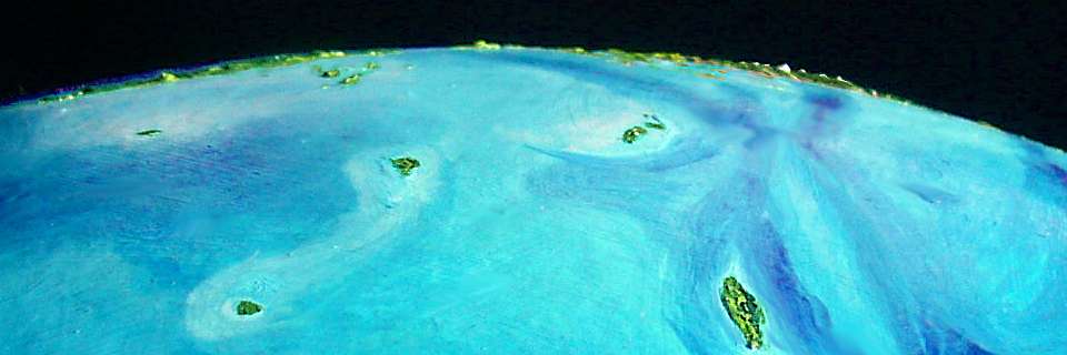
West of the long wall, a coral sea stretches 2-3000 km, though few of the shallows rise enough above sea level to be more than reefs. But at least eight do, creating archipelagoes of varying size and habitability.
THE MENDAÑA ISLANDS rise from shallow water, southwest of Peruvia. They're at least as big as Hawaii, and probably larger. The Mendañas are semi-arid, since they're partly in the rainshadow of the Peruvian Andes--though not as dry as our Galapagos, rainshadowed by our much higher Andean wall. Most summers see occasional typhoons, but rain is sparse in winter. The major isles--Mendaña, Quebrada, Bauer and Gallego, are low and brushy, with extensive woods only in the central hills. Southeast shores and ridges are generally greener, with scattered trees; northwest slopes (the lee side during storms, and getting more hot afternoon sun) are dry grass or brush.
On the smaller isles, fresh water is spotty; they just don't rise enough to wring water from the stingy breezes.
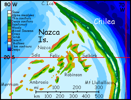
THE NAZCA ISLANDS off northern Chilea are even more extensive than the Mendañas--in fact, larger in area than all the other archipelagoes combined--but even drier, due to their latitude and to higher mountains upwind. The Nazcas' climate is semi-arid Mediterranean--most islands never see more than fog all summer. What rain does fall comes in the mild winters, persisting into spring in a good year. Most of the lowlands are brush and savanna.
The Nazcas are also more rugged than the Mendañas, and the major islands' spines snag more clouds, fog and light rains; this compensates some for the drier climate. There are forests on many heights, and down the shadier southern slopes. South coasts have a wetter Mediterranean climate (southern hemisphere, remember--they're facing the winter storms), with groves and strips of real woods, not just scattered trees in the rocky meadows.
About the nearest Terran approximation: the Canaries or perhaps the Cabo Verde Islands; though the Nazcas aren't as high or as varied. Just big! Four of the Nazcas are over 160 km (100 mi) long.
The outlying islands are quite different, resembling Caribbean islands, not the dry Galapagos. They're beyond the mainland's rainshadow.
BAUER ATOLL is a lonely tropical atoll in the far northwest. Its ring of coral islets are small, low and storm-vulnerable. Only a single sounding in one of the many bathymetric maps I studied was deep enough to guarantee at least a little dry land here on Abyssia, but every map shows water shallow enough for coral over quite a wide area, so reefs will be extensive--but will the islets be mere sandbars and rocks, or pocket Edens? The latitude is hot and rainy, so one would expect any islets to be verdant; but there's always the counter-example of our world's Clipperton Island, an equatorial coral ring where crabs strip the land bare, eating all seedlings. You just can't be sure what will evolve in deep isolation! Still, Clipperton's one tropical ruin against hundreds of green isles; and it probably went the way it did because its lagoon is cut off, stagnant. With a normal reef ecology to keep crabs under control... So let's assume our Bauer Islets are coconut heaven. But lonely! The Bauers are so far out they may never have been settled at all. Discovered? Maybe. But only maybe. On all Abyssia, only the Greek and Lena Is. are more isolated.
THE DANA ISLANDS are less lonely, but they're still so far out they get plenty of rain. The Danas are considerably larger, too, so fresh water should be easier to find and there's no question they'll support rich forests. Offshore, coral reefs extend in a straggling maze all the way east to the Mendañas--deadly for shipping, but a rich resource for local fishers in small boats. Or, of course, for semiaquatic people or intelligent seabirds who wouldn't need boats...
THE GOFAR ISLANDS are nearly as isolated as the Bauers, but larger and not right down at sea level. A bit further from the equator here, so the rains are seasonal, peaking in summer and trailing off in winter. Green and Polynesian just the same.
THE MENDOZA ISLANDS are drier; not just closer in to Peruvia's rainshadow (curse of the Galapagos!) but at a latitude where fewer storms hit. Here it takes a bit of a hill to push clouds upward, causing local rains; and the Mendozas aren't that high. Mendoza proper is nearly 100 km long (about 60 mi) but scrubby, with few year-round creeks, all on the south slope. The reefs around it, though, are as rich as those around the Danas. Fishing will be excellent. I project a chain of villages at creek-mouths, with that dreary interior mostly unsettled. I guess you could graze Galapagos turtles. For the wool and milk, you know.
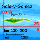
SALA-Y-GOMEZ is last but emphatically not least: huge, rugged, and rising from deep water like the keel of a capsized Titanic two hundred km long. Or a misplaced New Caledonia! The physical resemblance is uncanny. Sala's jagged spine rises over 600 m (c. 2000'), snagging clouds and creating distinct microclimates; three worlds in one. The south shore is rich rainforest; the craggy heights are misty cloudforest never seeing the sun; the north shore is sunny and drier, all groves and meadows, with short creekvalleys ideal for irrigated gardens.
Sala's great keel rises right just north of the Gomez Trough, several km deep; it forces cold, nutrient-rich water to rise from these depths; though coral reefs will be narrow off these precipitous shores, deepwater fishing will be superb, especially the south coast.
Those won't be the only boats you see. For reasons explained in the next section, I predict a world-class port on the north shore. Sala's culture won't be rustic--think Oahu, not Pitcairn.
2022 CORRECTION: the main map used to show Sala at about 95° west, near the edge of the map. I'm now convinced it's closer to 100° west, off the edge of the (old) map, so I've extended the map a bit to show Sala's true position--hundreds of miles farther out.
Not that the extra isolation affects its ecology, or shipping. Or shopping.
Intro - Western Isles - Ships and Cities - Chilea - Tsunamis - Biology
Though deeply isolated throughout prehistory, the Andeans were discovered soon after Abyssians mastered long-distance navigation. They quickly became important: for the two giants stretch from 4° to 36° south, blocking east-west shipping between Pacifica and the Atlantis Cluster. The only strait is a shallow hundred-mile passage between them, around 14° south. Ica and Lima, the ports flanking this vital Andean Strait, are busy places! So are Talara, at the northern tip of Peruvia, and Chanco, at the southern tip of Chilea, for the same reasons.
All these coasts, wet or dry, are ringed by extensive coral reefs--as big as Australia's Barrier Reefs. Fishing is superb. You'll need a local pilot, though, to guide you through the reef-maze. Deepwater ships avoid the isles and follow the Nazca Channel as long as possible--and even they must hire pilots to cut across the perilous shallows from its head to Lima.
You'd think that on a world with only 12% land, deep-sea shipping would be easy, but in fact Abyssian navigators have it rough. Shallow coral seas are much more extensive than on Earth, so wrecks are common.
The one great exception, the only safe port in the region, with no pilots (or their fees): Port Sala on Sala-y-Gomez. Situated on the island's drier north shore, which rises from deep water, Port Sala will be a major waystation for ships from Agassiz (and further west through the Harmon Canal, from West Pacifica, Filipinia and Whartonia) to the Lima Straits and on toward the New World: Atlantis, Azorea and the lesser continents around the Atlantic Rift.
Fresh water, fresh produce... fresh news.
Intro - Western Isles - Cities - Chilea: Rainshadows - Tsunamis - Biology
Deserts are rare on Abyssia, except for southwest Pacifica. So much of the sparse land elsewhere is maritime, and most mountains are too low to cast significant rainshadows. But the west coast of Chilea is quite dry, especially in the north. It's not the lunar landscape of our Atacama Desert, but it's sure not Taiwan either! Think Galapagos--rocks, cactus, dry brush, twisted little trees that bloom in a good year and brown in a bad. At this latitude, winds are weak and tend to come from inland much of the year; and storms don't make it over the central mountains, which average 2000 meters high (6600'); Mount Llullaillaco reaches 3160 meters (10,365'). It's snowcapped most of the year; the only alpine region for 4000 km (2500 mi).
In fact, Llullaillaco is much taller than it looks. Just offshore, the Andes Trench is as much as 11.5 km deep. Head to toe, Llullaillaco is the tallest peak on Abyssia, some 14.7 km tall--over half the height of Mt Olympus on Mars. Pretty respectable for a high-gravity planet like ours!
Incidentally, the common assertion that Mauna Kea is Earth's tallest peak, head-to-toe, is wrong; Abyssia is just Earth inverted, and the same altitude difference exists between our Andean peak, Llullaillaco, 6.7 km high, and the Andean Trench just offshore, some 8 km deep here. Plenty of other Andean peaks, measured this way, are close rivals--over 13 km tall. And the 2800-meter mountains of eastern Mindanao in the Philippines, right above the Philippine Trench, are well over 12 km base to top. Hawaii, a mere 10 km tall, just gets better press. Well, it's a freestanding massif.
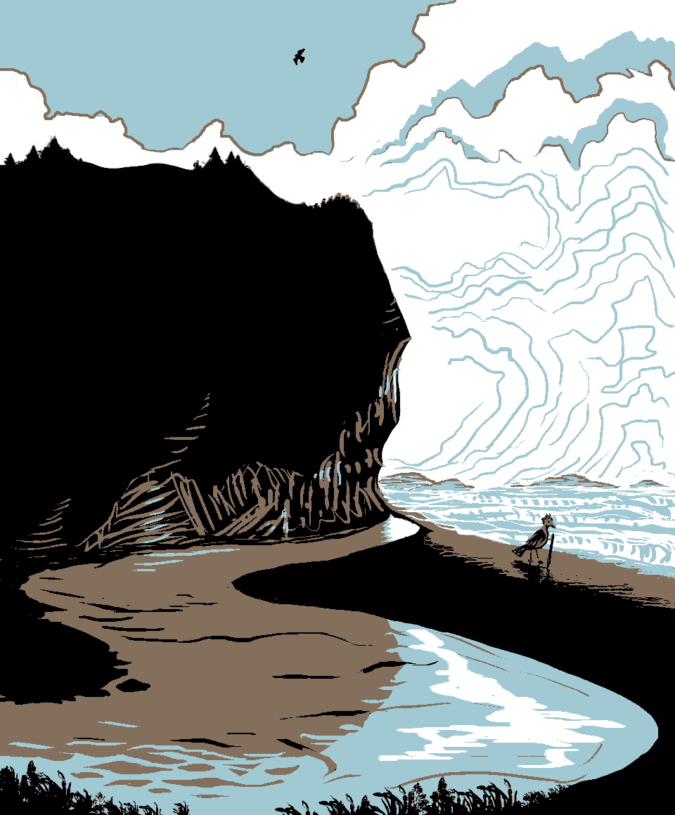
Andalga on beach, west Peruvia; faux print (2017) by Wayan after 'Pomponio's Beach' (1979), print by Tom Killion |
But I was speaking of the climatic effects of the mountains, and for that, only the portion of this great wall that's above water really counts. And even a near-drowned Andes Range less than half the height of ours is enough to sharply affect the west coast and the isles close offshore.
The east coast, in contrast, is lush throughout. Storms off the American Sea roll in unobstructed. The other big difference is that coral reefs are only a narrow fringe along this shore, for it drops off quickly into very deep water indeed: the Andean Trench I mentioned. Its very lowest point, the Aconcagua Deep off south-central Chilea, is more than 12 km down (40,000')--a kilometer deeper than any trench on Earth. It's still not the deepest on Abyssia! That, of course, is Everest Deep in the Himalayan Trench, nearly 14 km down (about 45,750'). But the Andean's respectable.
Intro - Western Isles - Cities - Chilea - Tsunamis - Biology
This Abyssian version of the Andean Trench isn't just large; it's just as tectonically busy as ours. Peruvia's and Chilea's lush east coasts, especially, rising as they do from deep water, are (unfortunately) ideal for tsunamis.
Great ports like Lima and Ica will be squeezed by social pressures just as severe as the tectonic plates they ride on: the seaward pressure of money, luring merchants to expand docks and warehouses and to settle near the waterfront, and the landward pressure of catastrophe every generation or two, urging those with longer memories and better imaginations to build a bit uphill. "Convenience breeds apathy" says the bumper sticker; but when in Lima (at least the Abyssian version), convenience brews catastrophe.
Intro - Western Isles - Cities - Chilea - Tsunamis - Biology
Deep isolation and a diverse landscape have made the Andean Archipelago a laboratory for speciation. The best Terran analogy is ancient New Zealand. It was a largely avian world, dominated by huge flightless birds, all of them endemic. Large land animals from other continents could not swim or drift here; it was just too far, and has been for 50 million years or more.
However... since "bird" means something a little different on Abyssia, interesting possibilities arise. Abyssian birds, like most vertebrates here, are variants on a basic six-limbed body plan; it's insects that have four. Thus, all but a few birds have small (but not vestigial) forelimbs tucked under wings or folded over their breasts; limbs typically evolved to snatch insects, groom feathers, pick fruit... and wield tools.

To over-generalize: most Terran birds fly a bit better, but Abyssian birds are more adept on the ground. For most, the difference is modest; but for large, intelligent birds, it matters!
Only two factors prevented Terran birds from achieving civilization despite high intelligence and socialization. Hand-feet are awkward; and flight limits absolute size, and thus brainweight.
But not on Abyssia! Nearly all Abyssian birds are handy; nearly all use tools. And the huge flightless species that tend to evolve on the most isolated of Abyssia's scattered landmasses lack the second limitation, too; their brains can grow well beyond raven-size. So it's birds much like our Moas (or more likely Aepyornis) that are the most likely candidates for intelligence; and they'll evolve most readily on isolated lands like the Andean Archipelago, not predator-infested continents like Pacifica. It may be that deepwater ships do not discover the Andean Isles and found Lima; it's quite possible that Lima discovers the world.
Not that this should surprise you. Abyssia, by its premise, is an upside-down, looking-glass, Alice sort of place. The dodo shall inherit the earth.
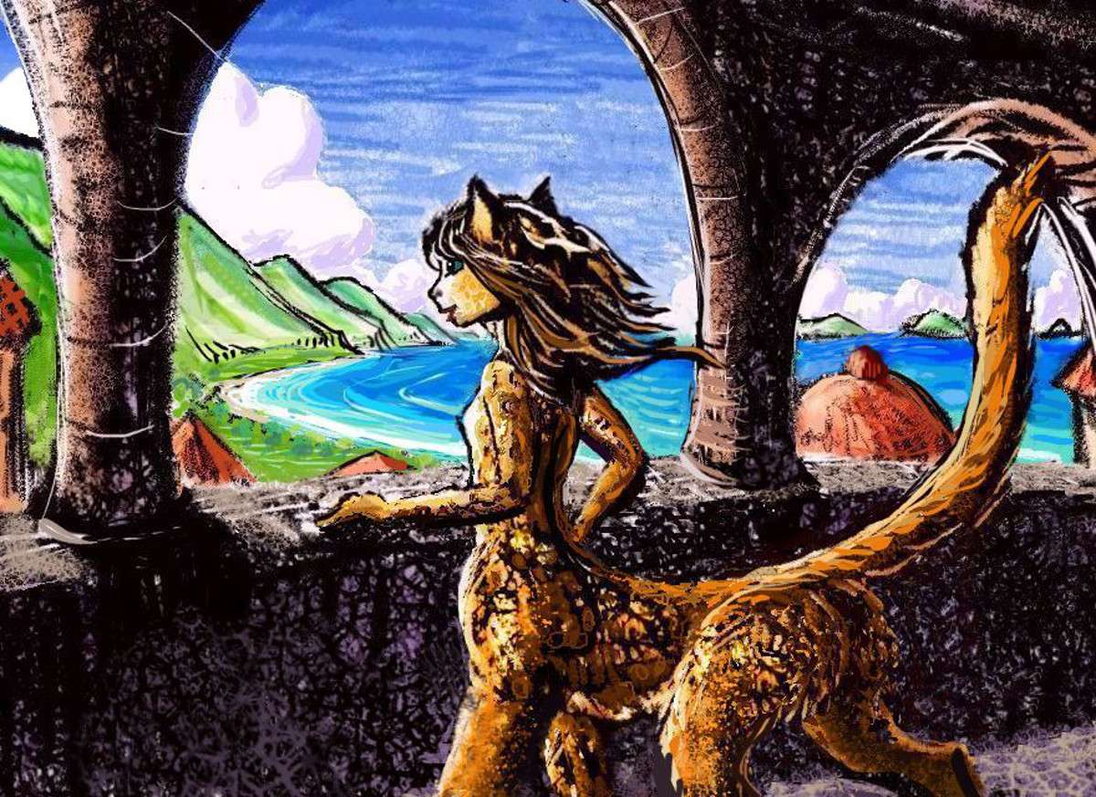
Though I'm not sure they'll be all that meek. Many of the extinct giant flightless birds in South America were big-beaked omnivores or predators, like Andalgalornis. In keeping with this, the species dominating Chilea and Peruvia, and spreading to the islands around the Nazca Sea, will be called Andalga. Loud and colorful (both in feathers and speech), with huge beaks, andalgas stand nearly as tall as the average human, and they seem bigger. Brassy. Feisty.
But not, these days, quite as fierce as they look. Like most Abyssians, they've learned trade pays better than piracy.
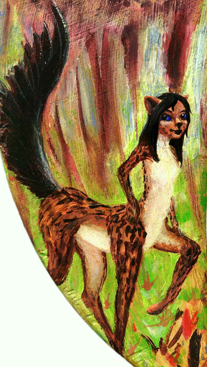
A leptaur from southern Atlantis |
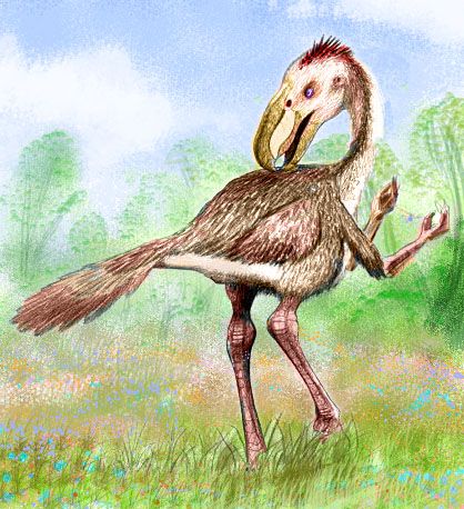
An andalga (female; male colors are louder) from Lima |

An equa from eastern Agassiz |
Still, after they've paid the going rates for pilots through the Lima Strait, quite a few equi and leptaur crews on voyages between the Atlantis Strip and Greater Pacifica will swear the Pirates of the Nazca Sea are alive and well.

Abyssia's homepage - map - peoples - regional tours - names
LISTS AND LINKS: More worlds? Planetocopia! - dreams of other worlds - ecology - climate change - evolution - natural disasters - terraforming - sculptures and 3D art -
World Dream Bank homepage - Art gallery - New stuff - Introductory sampler, best dreams, best art - On dreamwork - Books
Indexes: Subject - Author - Date - Names - Places - Art media/styles
Titles: A - B - C - D - E - F - G - H - IJ - KL - M - NO - PQ - R - Sa-Sk - Sl-Sz - T - UV - WXYZ
Email: wdreamb@yahoo.com - Catalog of art, books, CDs - Behind the Curtain: FAQs, bio, site map - Kindred sites