World Dream Bank
home -
add a dream -
newest -
art gallery -
sampler -
dreams by
title,
subject,
author,
date,
places,
names
Abyssia: Atlantis
by Chris Wayan, 2007-2012
for William Beebe and Otis Barton, first voyagers into the abyss
Abyssia home - down to
map -
building Abyssia -
geology & geography -
critters & cultures -
the clash of names -
more worlds? Planetocopia!
Intro
-
Names -
Holes -
NW Sounds -
Titanis -
North -
Sargasso Desert -
Leptaurs -
West -
East
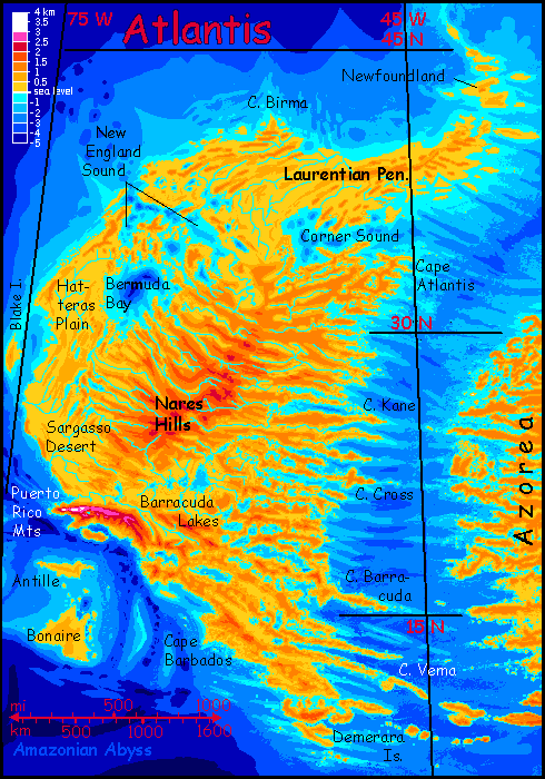
This page, stil under construction, describes Atlantis, the largest continent on the Atlantis Rise--the upside-down equivalent of our Atlantic Ocean. By Earth standards Atlantis is more a big island than a continent--a tropical-to-temperate land about half the size of Europe or the USA. Its shores, especially in the east, are rugged fracture zones--an endless procession of cliffy heads, deep sounds, islands and shoals, all perpendicular to the deep rift zone offshore separating Atlantis from Azorea, the smaller eastern continent.
New and casual visitors take note: these features aren't fantasy. They're inverted--up is down and down is up--but all these rugged landforms are there. Just hidden in the abyss.
Intro -
Coastlines and Names
-
Holes -
NW Sounds -
Titanis -
North -
Sargasso Desert -
Leptaurs -
West -
East
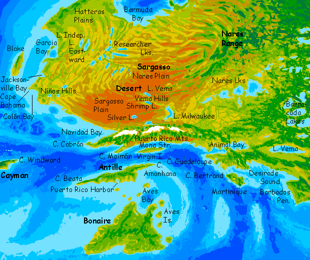
Much of Earth's sea floor is poorly mapped even today, and shorelines on Abyssia are correspondingly uncertain. But our North Atlantic has had heavy shipping and study over the last century or five... Also, the Atlantic Rift between the twin continents creates jagged fracture zones. The result? I'm more confident of Atlantis's topography than most parts of Abyssia.
Names are based on local seamounts, trenches, fracture zones and abyssal plains. Some are inevitable, like Atlantis; some involved choice. For example, one of the two continents in the northern Atlantic has to be called Atlantis of course; but which? I chose the larger western one, mainly because four abyssal plains fuse to form it and if it's not Atlantis I'd have to decide between Nares, Hatteras, Sargassia or Sohm--or Suhm, as the panel certifying scientific names for such features says Sohm Abyssal Plain, found in most atlases, is a misspelling. By calling this western continent Atlantis and the eastern one Azorea, I can avoid all that. (Most of it. Sohm Plain or Suhm? I'll leave it Sohm for now.)
Judgment calls, yes--but like the landforms, none of the names are fantasy or purely arbitrary.
We tend to think of the abyss as a featureless muddy plain. The truth is that every new sonar sweep reveals more complexity; it's quite rugged down there. The parallel fjordlike bays serrating so many Abyssian coasts are the result of huge fracture zones.
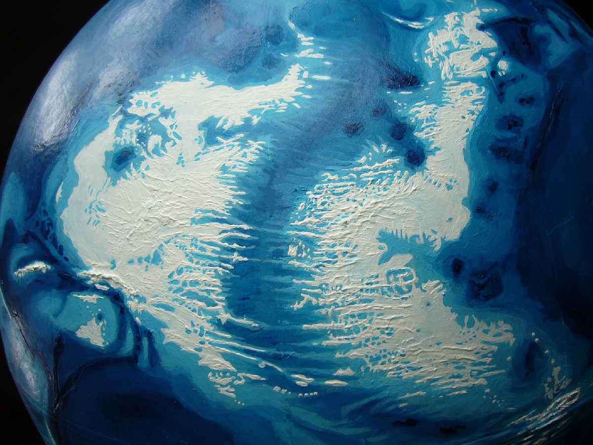
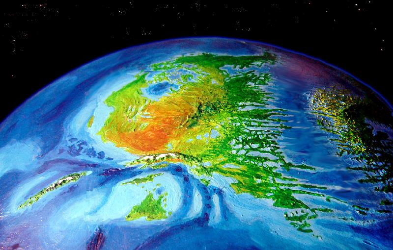
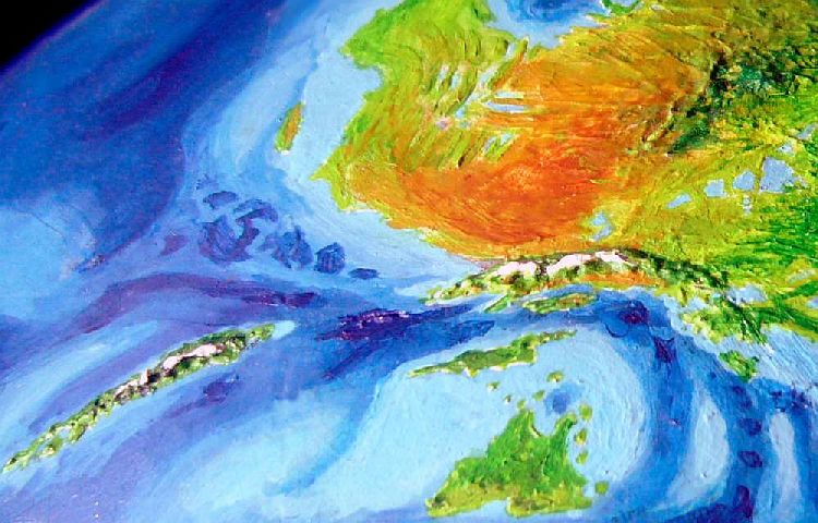
The relief map below, of the land without vegetation, shows Azorea on the left and Atlantis on the right, with the Atlantic Deep snaking between them. (Spain's in the upper right, the Caribbean in the lower left). Lacy, crazy coasts like these repeat all over Abyssia--you can see why it took five years to finish the relief and painting of this globe!

Intro -
Coastlines and Names -
Holes
-
NW Sounds -
Titanis -
North -
Sargasso Desert -
Leptaurs -
West -
East
Our sea-floor's peppered with volcanoes, far more than anyone expected. These are a bit of an scientific and esthetic problem on Abyssia--what's the tectonic explanation for all those conical pits? Abyssian geology would madden any Terran--but it's worth noting the reverse is true, too. Why not an active mantle with a lot of puckers where crust is crunched in a "downdraft", a world with rifts that pull inward instead of spreading? This isn't theoretical: puckers like this can be found on Venus ("inward" coronae), and the hottest convection system of all has lots of them: we call them sunspots. No volcanic cones on the sun!
Abyssia doesn't spew, it just sucks.
Intro -
Names -
Holes -
Northwest Sounds
-
Titanis -
North -
Sargasso Desert -
Leptaurs -
West -
East
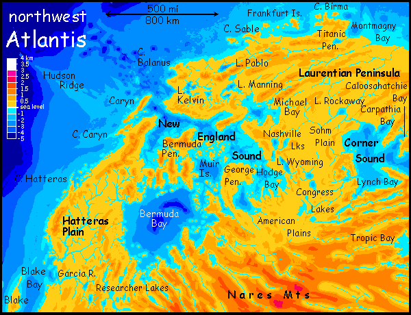
The most prominent example of these "puckerlakes" on Atlantis is in the northwest, around New England Sound. The "blue holes" in the sound and the equally deep lakes north of it are the inverted equivalent of our New England Seamount Chain, which stretches from Cape Cod southeast for at least a thousand miles to Congress and Lynch Seamounts--lakes here on Atlantis, of course. Despite the name, this "puckerland" extends far beyond New England's latitude. Its culmination is arguably the deep blue hole of Bermuda Bay. As with the Sargasso coast, the mild Mediterranean climate and wildly indented shorelines will encourage trade by water not land. Think Greece.
Time for another wacko Wayan theory! On top of Abyssia itself, I mean. Gimme room, here (deep breath). 2400 years ago, the Greeks developed relentlessly logical philosophical schools and the first serious science. You think that's Euro bias? Not. Exactly one person in the ancient world, Eratosthenes, deduced the circumference of the Earth and even the size and distance of the moon; that's as impressive, given his resources (travelers' tales plus a stick and some dirt)--as NASA's moon landings. So in the ecological sense, science first flowered in a Mediterranean climate around latitude 37 north.
Now... millennia later, where's the world's largest nexus of intellectuals? By patents and degrees (and kooky progressive social movements), I'd argue it's the San Francisco Bay Area: Berkeley, Stanford, Silicon Valley. Where is that? In a Mediterranean climate, latitude 37 north.
What is it about that climate? Mild but fertile, so you have leisure time? But not TOO nice--farther south, it's warm out all the time--and you get surfers not coders. Farther north, winters get everyone too glum and shoe-gazy... oh well. I warned you. Wacko theory. I will not mention that other great kook-magnet, Barcelona, or Melbourne, Perth, Auckland... Half the world's most livable, advanced cities are latitude 35-40, in a Mediterranean climate. Pure chance. Yeah.
So where will Atlantean intellectuality center, where will its great universities be? Why, on the west coast in that lovely Mediterranean climate of course. Maybe a bit lower in the Latitude 30s--Abyssians like it warmer than us, they never had to adapt to Ice Age winters as Earth life did. But the balance between enough rain and enough sun to foster a high culture looks ideal here somewhere around New England Sound. Let's postulate rival universities, one on northern Cape Bermuda, at the heart of the Sound where ships from all over this inland sea must pass, and the other on Caryn Island near the mouth of the Sound, for the same reason. Perhaps even a third at the mouth of the Kelvin River, because... ditto.
My guess is that such campuses will be architecturally modest and light by our standards--no gothic towers like Oxford or Harvard. These are seismically active lands! Low, sprawling quads (or possibly hexes--remember how many limbs these folks have! Are you sure our buildings aren't a reflection of OUR bodies?) with thatched or shingled roofs. The only stone building of any size will be the library--for librarians, fire's worse than a quake. Arched colonnades will be common--these are ideal for this sort of climate, providing outdoor patches of both sun and shade to sit in (depending on temperature), and arches reflect and diffuse sun on the floor--no need for artificial light, where squarish ceilings suck light up. It's why you see arched ceilings all over the Arabic and Roman world.
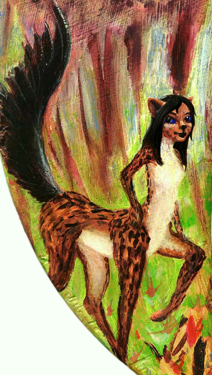
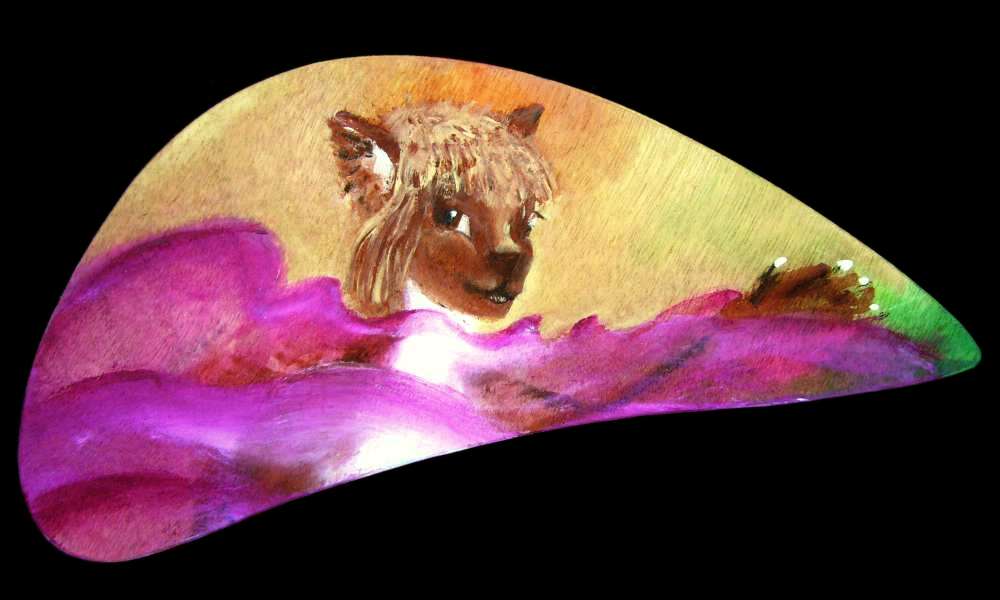
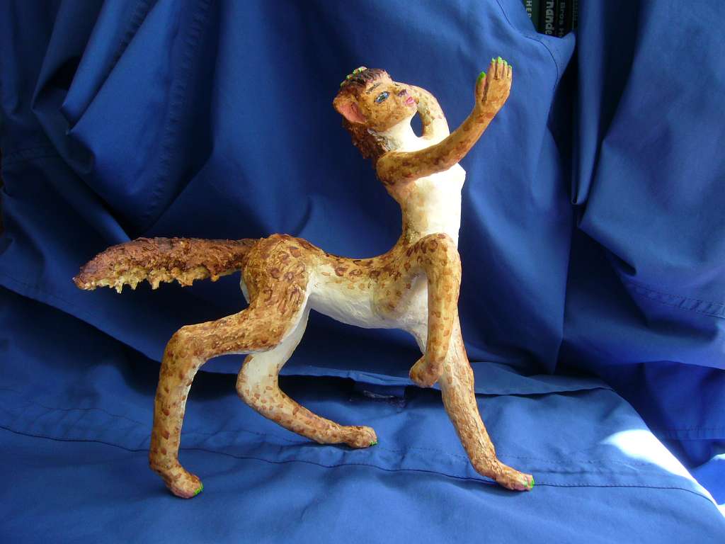
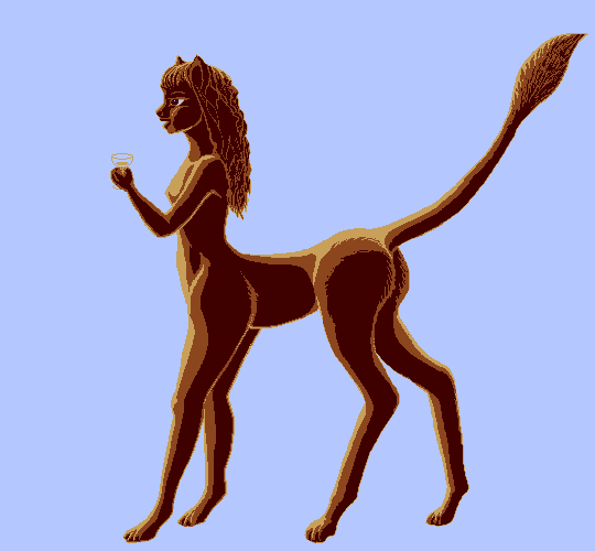
Why do I mention all this? Well, I met this charming leptaur professor at a symposium and she graciously allowed me to sketch her in sepiatone, as long as the conversation, wine and cheese held out (and, unlike such human events, a ton of celery to balance the two strong-tasting items. Leptaurs, despite looking feline, are slightly less carnivorous than humans; they want green stuff with their protein and booze.)
Northeast a bit from this intellectual heartland... the Titanic Peninsula (upper right on map below) isn't called that for its size, but its history. No, you won't find a huge rusting steamship hulk high on the headlands:
- First of all, the Titanic's grave is deep, but not deep enough to become land on Abyssia when you turn the world inside out: the Titanic's grave is a good 100 km east of Cape Birma, among those undersea ridges past the mouth of Montmagny Bay (X marks the approximate spot).
- Second, Abyssia isn't Earth after some fourth-dimensional inside-out catastrophe, but an alternate world; no "unsinkable" liner overpacked with class-segregated passengers ever headed out from London to New York, to become the tragic subject of moralistic songs and overlong movies. What London, what New York? Without Africa's savannas, what humans? Humanity never evolved here! If there are clipper ships plying the sealanes between Azorea and the sheltered ports of New England Sound, their skippers will be dodos, or moas, or foxtaurs.
- Third, no icebergs lurk in these northern seas to hit any ship--human steamer or dodo clipper. Without a Greenland, almost no glaciers calve into the sea. So instead of a morality play hinting that an 'unsinkable' ship's builders provoked God to plant an iceberg in the one spot to crush their arrogance, any Abyssian version of the story must be more shameful than tragic--for it requires a navigator dumb enough (or a captain drunk enough) to hit not mobile ice but a stable, known, well-charted reef. Not the Titanic's high morality play, but the sordidness of the Exxon Valdez.
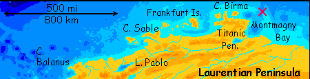
However... all that said, we must have a Titanic here--more likely a sailing ship than a steamer, but a great ship just the same--titanic enough by Abyssian standards to merit the name. It snagged a reef off Cape Birma and sank with a great loss of life, enough to stamp its name on the vicinity.
Why must I let Earth's sorry tale spill over into Abyssia? Well, the region's nomenclature impels me. Not just Titanic itself, but Montmagny, Birma and Frankfurt are all names of Earthly sea features commemorating the ships that hunted for survivors of the disaster.
Nomenclature-fueled tragedy! Not for the first time on Abyssia, either.
Intro -
Names -
Holes -
NW Sounds -
North -
On Titanis
-
The Sargasso Desert -
Leptaurs -
West -
East
One more tiny Titanic item (Oh, how I enjoyed writing that phrase!)
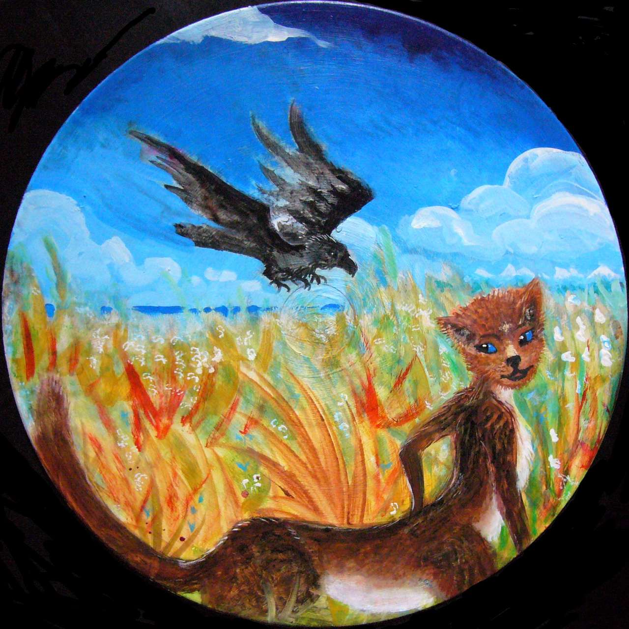
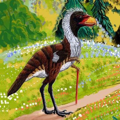
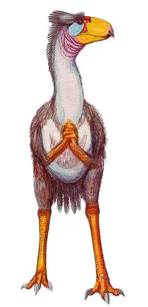
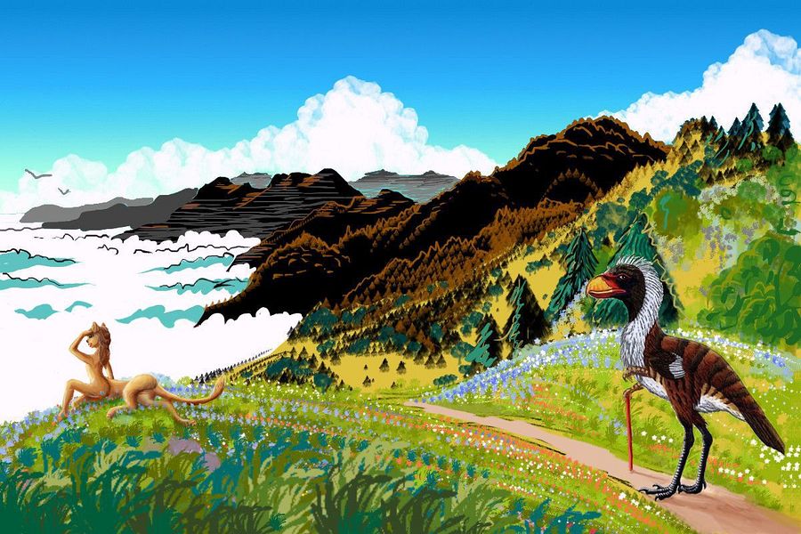
On Terra, fossils of an extinct flightless bird that once roamed the forests of North America got named, purely for their size, Titanis. On Abyssia, an analogous flightless bird is not at all extinct, and lives in the forests of Atlantis. Here are two rival reconstructions from Titanis bones (by P. Gryz to the left and Dmitri Bogdanov to the right) altered to fit Abyssian biology and history.
It's not surprising this Titanis survived when ours died out. Abyssian flightless birds have small forelimbs: they can use tools and brandish weapons; that led to a growth in brainsize. Stone Age mammalian savages had no advantage against these big, smart, well-armed birds, and eventually found wary trade (or at least leaving their feisty neighbors alone) less costly than war. Groups that traded did better, and trade became the norm. Eventually, closer cooperation did.
It also helped that these mammals, on Atlantis, weren't fierce hairless apes adapted to Ice Age cold and a meat-heavy diet; instead they're leptaurs, omnivorous, savanna-bred, heat-loving, easy-going centauroids who just don't much want to live in cool, shady forests. The two species may each be top of the food chain in their niches, but they prefer different niches.
So in modern Atlantis, the two species coexist in a pattern that's seen all over Abyssia: flightless birds dominating rainforests, coasts and smaller islands, mammals dominating veldt, savanna and continental interiors--with much mixing and many exceptions. The most notable is that most ships have a lot of leptaur sailors; they can paddle in seawater where Titani just sink.
Anyway, here on the Titanic Peninsula, in the chilly north woods of the mainland, and all down the rainy east coast, the majority of the population is literally (indeed, scientifically!) Titanic. Just a coincidence, I'm sure.
Intro -
Names -
Holes -
NW Sounds -
Titanis -
Far North
-
Sargasso Desert -
Leptaurs -
West -
East
Atlantis's far north--the Laurentian Peninsula and the islands off its tip--isn't Abyssia's northernmost point: both Pacifica and Azorea extend several degrees further north, and of course the Lena Islands are polar (though possibly undiscovered, certainly uninhabited, and practically uninhabitable). But still, Laurentia's fourth; respectable on a world with little polar or even subpolar land.
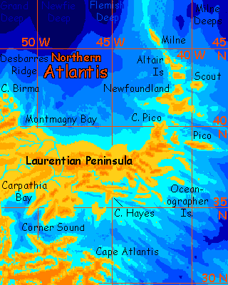
So how cold is it? Oh, not very. The north shore of the Laurentian Peninsula's barely reaches latitude 40°; only the Isle of Milne passes 45° north. Midway between pole and equator! And with no Greenland souring the climate, these are deep-forested lands with warm but not hot summers and cool rainy winters. True, occasionally you'll see snow, a rarity on Abyssia; but by our standards, it's mild.
The topography is fairly gentle too; low, winding Appalachian ridges and broad plains. The islands and the tip of the Laurentian Peninsula, gnawed by the sea, are more rugged, and the backbone of the Peninsula reaches 1000 m in spots (3300').
The southeast coast is more ragged than the north; here you'll find fracture-zone fjords with scenic cliffs and falls; but it's more restrained than fractal madness you see farther south. Lower cliffs, less of a maze. Offshore, the Atlantis Rift is spreading enough to corrugate the land, but more slowly here than in the south; and it shows.
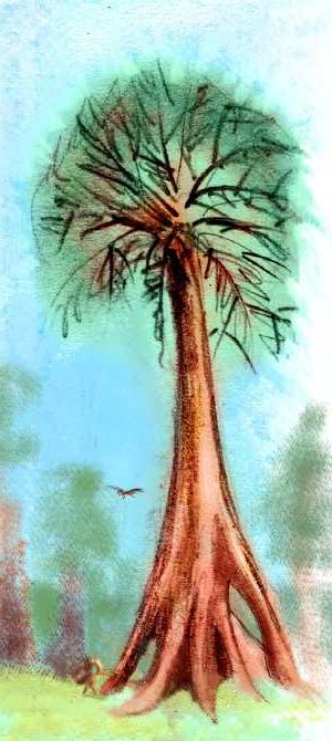
The most impressive scenic attraction: the Big Trees. These close cousins to our Sierra Nevada sequoia have its shaggy, ruddy bark, but the coastal habitat, height and slimness of our coast redwood, with "flying buttresses" rather like swamp cypress or mangrove. From Cape Balanus on New England Sound, north to Cape Birma and east all the way to Cape Pico and the Isles of Newfoundland, groves of these monsters rise. In sheltered bottomlands they grow 400' tall.
Intro -
Names -
Holes -
NW Sounds -
North -
Titanis -
The Sargasso Desert
-
Leptaurs -
West -
East
Deserts are rare on Abyssia except for southwest Pacifica. So much of the sparse land elsewhere is maritime, and most mountains are too low to cast significant rainshadows. But Atlantis is an exception. It's the fourth largest continent, and perhaps the most continental of all--almost Earthlike in its compactness and continuity. So Atlantis has enough inland inland to develop a true desert in the southwest, much like our North America does at a similar latitude.
Winds here in the Sargasso Desert tend to come from inland much of the year, off the Nares Mountains to the northeast. Storms can't come in from the south--they're blocked by the towering snowy Puerto Rico Range. Mt Milwaukee, at about 3900 meters (12,800'), is the highest point in this hemisphere. Yes, I meant it--that's the highest peak on half of Abyssia. Scenic, as tall as Fuji, but just a speedbump next to our Andes or Himalayas. Abyssia's land isn't just smaller in area than Earth; it's mostly low.
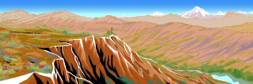
In summer, Atlantis's southwestern lowlands get so hot they create a local monsoon, drawing thunderstorms over the plains. These can be locally torrential but are inconsistent and brief overall. Rains in winter are sparse and rare except along the coast south of the Puerto Ricos.
The mountains, however, are quite pleasant; harvesting thundershowers in summer and snow in winter, they're temperate islands in the desert sea. And from the Puerto Ricos and even the Nares flow year-round creeks that fuse into the shallow, muddy, meandering Sargasso River, full of reedy islands and lined with trees; it wanders west over the dry plains to the sea, rather like our Senegal River.
The islands off southwest Atlantis coast, plus the infrequency of storms, will encourage the development of boats, just as the gentle weather and frequent islands of the Mediterranean did in the ancient Greco-Roman world; so I expect the Isle of Blake, Martinique and the Virgin Island to resemble the mainland culturally and biologically. The strait from Virgin to rugged Antille isn't much wider; its tall mountains will be visible on a good day.
From Antille's south shore, the Aves Islands lead to huge Bonaire, big as our Cuba or Florida. Hilly and a bit drier than most of our Caribbean islands--southern Atlantis lies upwind, intercepting some rain, though not all like the Puerto Rico Range--the hills of southern Atlantis are rugged but low, and jungle-clad. Nearly as much moisture rises from those rainforests as falls on them. Enough of it reaches Bonaire to keep it green.
Two more great islands even bigger than Bonaire lie much farther offshore to the west. No hints of them will be visible from the mainland or any of the islands I've mentioned; coastal fishers won't soon find them. I doubt they'll ever find Albatrosia--it's 2000 km out, and will have as isolate an ecology as Hawaii or Madagascar. But the nearer one, Cayman, merely hundreds of km out, will I think be eventually settled by Atlanteans native to this dry, mountainous southwest coast and its island; and they'll find many familiar plants and animals, from storm-blown strays.
Who will these Atlanteans be? Well...
Intro -
Names -
Holes -
NW Sounds -
North -
Titanis -
Sargasso Desert -
On Leptaurs
-
West -
East
These savannas around the Sargasso Desert are the biggest in this hemisphere by far--so much of Abyssia's forest! That's had evolutionary consequences. Conditions in Hatteras, the Researcher Lakes, the Niños Hills, and especially the savannas around the Nares Lakes are as close to East Africa as we'll find in this hemisphere. That may lead to the evolution of an intelligent species. Probably not apes; remember that Abyssian mammals are best described as centauroid, so it isn't just bipeds and knuckle-walkers who have a free hand to explore tool use!
In the far hemisphere, I've pictured two such centauroids achieving intelligence: foxtaurs on Pacifica and equi on Agassiz to the south. Let's explore a third:
Here on Atlantis, social bands of leptaurs have discovered fire. They won't be obligate carnivores like our cats; hunting is hard and dangerous, so strict carnivores live short lives--a teenage lion is old. So while our leptaurs have builds and pelts a little like Terran leopards, the name's purely descriptive; they're omnivores. And there's plenty of omni to vore! The brushy, patchy savanna and woods of southwest Atlantis have tropical fruit trees, berry patches, nuts, greens, seeds parchable in campfires, shallow lakes full of crayfish and turtles... invent nets and snare birds, invent the hook and line and catch fish... why hunt big game?
My guess is they'll develop tools more to keep from being big game themselves--such savanna will have both midsize pack predators and big solitary hunters. But then, I'm a contrarian about human evolution too--I suspect defense not offense was the drive behind human weapons innovation. Lunch is never vital; not being lunch is. And that's shaped us; our childhood fear of monsters echoes a very long developmental stage. "Ontogeny recapitulates phylogeny" not just fetally, but psychologically. And we haven't yet fully outgrown that phase! At least some of us. Weapons and the demonization of enemies in war both grow from the ancestral terror of being devoured more than from a lust to devour. That's shallower and more recent: mere Ice Age atavism, recalling a time when some humans became top predators and turned highly carnivorous. But for millions of years, not mere thousands, fire and crude stone weapons were defenses, and we were still mostly herbivorous.
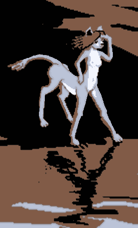
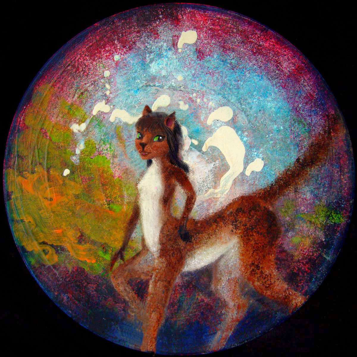
The above are (very) tentative sketches. I know there's a lot of variation. How much of that is diversity between subspecies, and how much my present uncertainty? Uh... both.
One more sketch in a different medium! Here's a sculpture of a leptaur singer-dancer in a cabaret (no, not a lepton; they audition too, but never get the part. "Sorry, you're too short.")
I apologize for the roughness (she's carved out of spackle with coathanger bones) but you can at least get the idea.
Intro -
Names -
Holes -
NW Sounds -
North -
Titanis -
Sargasso Desert -
Leptaurs -
West Coast
-
East
You may have noticed a peculiarity in the borderlands of the Sargasso Desert. On Earth, most west coasts at the latitude of Blake Bay and Hatteras Plain are desert too. But the orbital photo shows they're only semi-arid: savanna, with some trees in the hills. Quite Mediterranean/Californian.
Why's the Atlantean desert so small? The reason: prevailing winds in Hatteras don't come from the mountains or the Sargasso Desert (either one would guarantee us a Hatteras Desert nearly as big as the Sargasso), but from the northwest. No Rockies or Atlas Mountains to block storms--fronts roll off the great North Sea, across the Laurentian Peninsula, and then recharge over New England Sound and Bermuda Bay and Corner Sound.
You see, the recipe for deserts isn't really west coast, latitude 20s to 30s but simply too much land upwind. On Earth, they're usually the same--but not always on poor swiss-cheese Abyssia, full of holes where we have seamounts! Holes often full of water.
Turns out those puckers are good for something.
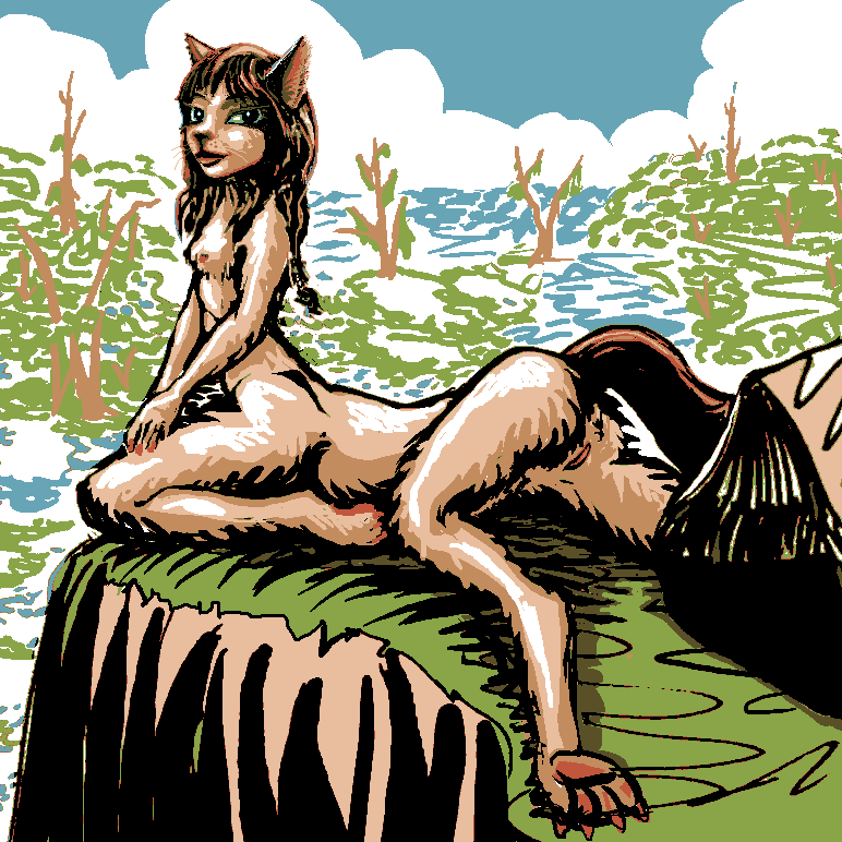
On the ground, this extra rain means the region is prosperous farm country. The majority are leptaurs, but with a considerable minority of titani, especially on the scenic Hatteras Coast and up in the cooler, more wooded hills.
Leptaur and titanis on coastal road, Cape Hatteras, western Atlantis; based on Tom Killion's print of Big Sur, 'Timbertop'
And of course in ports. Those cooling breezes off the sea invigorate the heat-intolerant titani, yes, but mainly it's that other breeze. The one scented with profit.
Intro -
Names -
Holes -
NW Sounds -
North -
Titanis -
Sargasso Desert -
Leptaurs -
West -
The Eastern Fjords
All in good time, my pretty, all in good time! I did say this article was under construction... I'm currently combing through the GEBCO database of thousands of undersea names and features, one by one, to see if I can dredge up more names for some of these fjords and capes and lakes.
Overall, I'm finding that mapped and named features in this southeastern zone are much scanter than in the north. That's not the region's fault--it seems quite rugged and interesting. It's oceanographic bias. The north is closer to shipping lanes between European and American ports--and they, not tiny Caribbean islands, are the ones with the money for deepwater research. Every little hump off Portugal, the Azores and New York is named; not down here.
Okay, the Researcher Deep surprised me. It's an impressive undersea mountain range on Earth--one of its peaks, Vayda, is taller than the Matterhorn, rising within a few hundred meters of the surface. On Abyssia, it's a hole about 4500 m (14,800') deep.
But it may not be an exception--just a region that one boat (the Researcher, logically enough) happened to map in detail. ALL the southeast may be like this! It's clearly scenic, even spectacular, with rugged ridges (even cliffs and scarps) along fracture zones as yet unnamed. Between them, freshwater lakes and great tropical fjords (full of jumbo shrimp and other tasty oxymorons, no doubt! But what else can I call such long, cliffwalled saltwater sounds?)
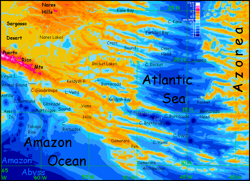 I apologize for the inconsistencies between the Southeast and Southwest maps. I brilliantly managed to destroy my master map of Atlantis, and had to redraw these maps from scratch, based on photos of my Abyssia globe (painted and molded to reflect data I lacked when first charting Atlantis). I think this map gives a more accurate picture of the eastern capes and fjords; the Southwest map is better at showing vegetation and implying climate belts. I need to re-consult some oceanic atlases before trying to reconcile the two.
Ecologically, what's this coast like? Oh, mostly warm and green--quite Floridian in the lowlands. But a Florida with cooler highlands atop spectacular cliffs. What's it like up there? Appalachia? Mexico? Roraima? Lots of equivalents of Angel Falls, that's for sure.
Aside from generous rainfall, how's the weather? Mild by Dixie standards--summers do see tropical storms, but fewer full-on Caribbean hurricanes: this Atlantic Sea is much narrower than ours, so storm-spirals have just a few days of warm water to feed on before they hit land and start to starve. It takes elbow room to brew a good hurricane--same as it takes a long "fetch" to generate big waves (there's a reason most great surfing's in the Pacific). And this shrunken and nearly landlocked Atlantic, no wider anywhere than our Gulf of Mexico, lacks the fetch to generate many big hurricanes.
Not that the leptaurs are crying over that. Dry cats are happy cats.

Cave painting of leptaur & trees, Shrimp Cave, Sargasso Desert, Atlantis
 TOURS: this route snakes around Abyssia's major lands -
Lena Is. (brr!) -
Greek Is. -
Atlantis -
Azorea -
Cayman and Albatrosia -
Andean Is. -
Scotia Is. -
Morningtonia -
Agassiz -
South Pacifica -
East Pacifica -
Hawaiian Sea -
Pacifica Desert -
Filipinia -
Banda Is. -
Vityaz Archipelago -
Tasman Is. -
The Bight -
Whartonia -
Chagosia -
Somalia -
Mascarenia and Crozetia -
Weddellia -
Argentia -
Pernambuco -
Angolia -
Tristania -
Agulhas group
TOURS: this route snakes around Abyssia's major lands -
Lena Is. (brr!) -
Greek Is. -
Atlantis -
Azorea -
Cayman and Albatrosia -
Andean Is. -
Scotia Is. -
Morningtonia -
Agassiz -
South Pacifica -
East Pacifica -
Hawaiian Sea -
Pacifica Desert -
Filipinia -
Banda Is. -
Vityaz Archipelago -
Tasman Is. -
The Bight -
Whartonia -
Chagosia -
Somalia -
Mascarenia and Crozetia -
Weddellia -
Argentia -
Pernambuco -
Angolia -
Tristania -
Agulhas group
Abyssia's homepage - map - peoples - regional tours - names
LISTS AND LINKS: More worlds? Planetocopia! - dreams of other worlds - ecology - climate change - evolution - natural disasters - terraforming - sculptures and 3D art -
World Dream Bank homepage - Art gallery - New stuff - Introductory sampler, best dreams, best art - On dreamwork - Books
Indexes: Subject - Author - Date - Names - Places - Art media/styles
Titles: A - B - C - D - E - F - G - H - IJ - KL - M - NO - PQ - R - Sa-Sk - Sl-Sz - T - UV - WXYZ
Email: wdreamb@yahoo.com - Catalog of art, books, CDs - Behind the Curtain: FAQs, bio, site map - Kindred sites