World Dream Bank
home -
add a dream -
newest -
art gallery -
sampler -
dreams by
title,
subject,
author,
date,
places,
names
Abyssia: Azorea
by Chris Wayan, 2007-2017
for William Beebe and Otis Barton, first voyagers into the abyss
Abyssia home - down to
map -
building Abyssia -
geology & geography -
critters & cultures -
the clash of names -
more worlds? Planetocopia!
Intro
-
Mapping -
Holes -
Climate -
People -
Northern Isles -
North Azorea -
Midlands -
South -
Leone
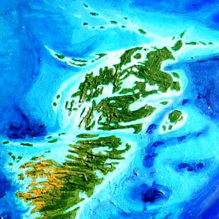
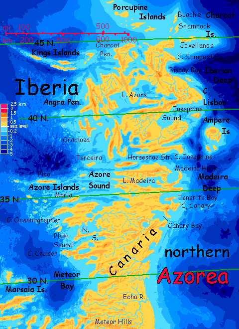
Azorea is the eastern continent on the Atlantis Rise--Abyssia's upside-down equivalent of our North Atlantic Basin, just east of the Azore Islands. Though I have to admit, Azorea would be named Atlantis if it didn't have a big sister to the west that fits the name even better.

Azorea's about half the size of Australia, reaching from the temperate zone to the tropics. Its shores, especially in the west, are jagged fracture zones--an endless procession of cliffy heads, deep sounds, islands and shoals, all perpendicular to the deep rift zone offshore separating Azorea from Atlantis, the western continent.
Intro -
Mapping and Naming
-
Holes -
Climate -
People -
Northern Isles -
North Azorea -
Midlands -
South -
Leone
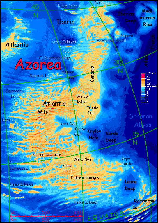
Names are based on local seamounts, trenches, fracture zones and abyssal plains. Some are inevitable, like Atlantis; some involved choice. For example, one of the two continents in the northern Atlantic has to be called Atlantis of course; but which? I chose the larger western one mainly because four abyssal plains fuse to form it, and if it's not Atlantis I'd have to decide between Nares, Sohm, Hatteras or Sargassia. So it's Atlantis in the west, Azorea in the east.
Judgment calls, yes--but none of the names are fantasy or purely arbitrary. Many Azorean names, especially in the north, are from seamounts; in the midlands and south, they're from Terran fracture zones like Atlantis, Kane, Barracuda, Vema, Doldrum and Guinea; invisible on Earth, they're prominent on Abyssia.
On Earth, small abyssal plains aren't just unseen but often unnamed; or they end up named for the nearest archipelago or seamount. On Abyssia, these deeps become islands, capes or hills. This can cause confusion. Cape Verde is a good example; it's not named directly for the African cape or archipelago--it's well south and west of those--it's the actual name for that stretch of abyss (more or less).
My point is, don't assume I've carelessly displaced familiar names hundreds or thousands of kilometers. It's not (always) sloppy cartography.
Desperation, maybe. I do displace some names, particularly well-known Terran seamounts; they often form holes too far off Azorea's shore to create bays, but I still apply the name to the nearest features that are visible.
Much of our sea floor, even today, isn't well mapped, and shorelines on Abyssia are correspondingly uncertain. But our North Atlantic has had heavy shipping and study over the last century or five... Also, the Atlantic Rift between the twin continents creates jagged fracture zones. The result? Even though I've had to struggle with names, I'm more confident of Azorea's complex topography than most parts of Abyssia.
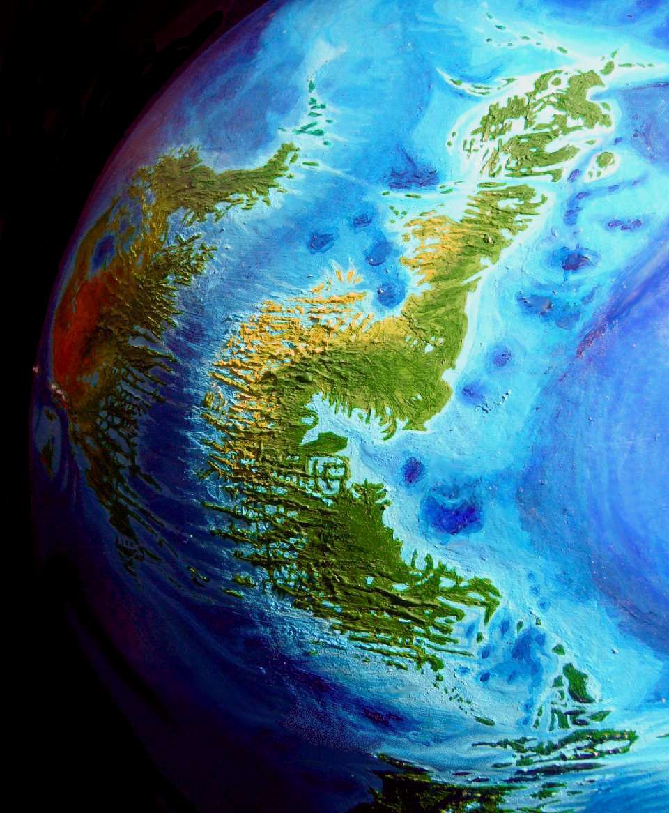
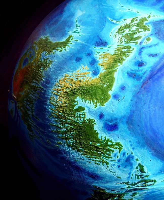
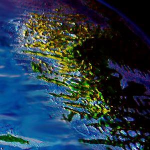
We tend to think of the abyss as featureless muddy plains. But the truth is that every new sonar sweep reveals more complexity; it's quite rugged down there. The parallel fjordlike bays serrating so many Abyssian coasts are the result of huge fracture zones, and Azorea's a prime example. The orbital photo above shows the deep blue Amazonian Abyss (with sun-glare); just north, Atlantis is on the left, Azorea on the right, with the Atlantic Deep snaking between them.
Lacy, crazy coasts like these repeat all over Abyssia--you can see why it took years to finish the relief and painting of this globe!
Intro -
Mapping -
Big Blue Holes
-
Climate -
People -
Northern Isles -
North Azorea -
Midlands -
South -
Leone
Our sea-floor's peppered with volcanoes, far more than anyone expected. These are a bit of an scientific and esthetic problem on Abyssia--what's the tectonic explanation for all those conical pits? Abyssian geology would madden any Terran--but it's worth noting the reverse is true, too. Why not an active mantle with a lot of puckers where crust is crunched in a "downdraft", a world with rifts that pull inward instead of spreading? This isn't theoretical: puckers like this can be found on Venus ("inward" coronae), and the hottest convection system of all has lots of them: we call them sunspots. No volcanic cones on the sun!
Abyssia doesn't spew, it just sucks.
Azorea's (relatively few) puckers are offshore, where they're less visible; but you can see a string of them off the northeast coast, and a tongue of them (our Azores and nearby seamounts like Plato, Cruiser and Meteor) stick into the northwest, creating Meteor Bay. But overall, Azorea has few deep puckers; none on land. That's logical--our Atlantic Ocean has relatively few islands. Consequently, Azorea looks almost Terran. Almost.
Intro -
Mapping -
Holes -
Climate and Relief
-
People -
Northern Isles -
North Azorea -
Midlands -
South -
Leone
Deserts are rare on Abyssia, except for the supercontinent of Pacifica. So much of the sparse land elsewhere is maritime, and most Abyssian mountains are too low to cast significant rainshadows. Azorea is typical. Low, broken, and dotted with great lakes, Azorea has no large stretches of desert.
But the western valleys of the Atlantis Range are distinctly drier--a quite Mediterranean strip. It's narrow, though, rarely reaching more than 1-200 km inland. Winds here tend to come from inland much of the year, off the peaks of the Atlantis Range; they've wrung most of the rain out of that air, greening their east slopes.
Still, this isn't the stark back side of the Atlas Mountains, or even Nevada, caught between the Rockies and the Sierra Nevada. Azorea's tallest peaks are only waist-high to such Terran mountain walls; even lower than Australia's Barrier Range or the Appalachians. The highest peak, Mt Atlantis, is little more than 1800 m (about 6000') and the continental divide is mostly under a kilometer high.
No surprise. Abyssia has not just less land than Earth; it's consistently low. Not always gentler, but lower. Only a modest rain-barrier!
The mountains are quite pleasant; harvesting thundershowers in summer and rain in winter (even some snow in the Atlantis Range); they're temperate islands above generally muggy coasts. From the heights, year-round creeks run east into boggy lakes and dense woods, or west into sunnier, drier valleys, fusing into shallow rivers full of reedy islands and lined with trees, but with open savanna above the bottomlands.
These sunny western floodplains are ideal for irrigation (and the drier weather more suited to food-storage, encouraging planning, surpluses and more organized societies). Since each valley is cut off by cliffs and ridges of the fracture zones, they may develop independent cultures, as did the ancient coastal Peruvians.
But who will our Atlanteans be?
Intro -
Mapping -
Holes -
Climate -
People
-
Northern Isles -
North Azorea -
Midlands -
South -
Leone
Like most regions of Abyssia, Azorea will most likely have more than one intelligent species, probably living and working together (if not always in harmony, as you'll see).
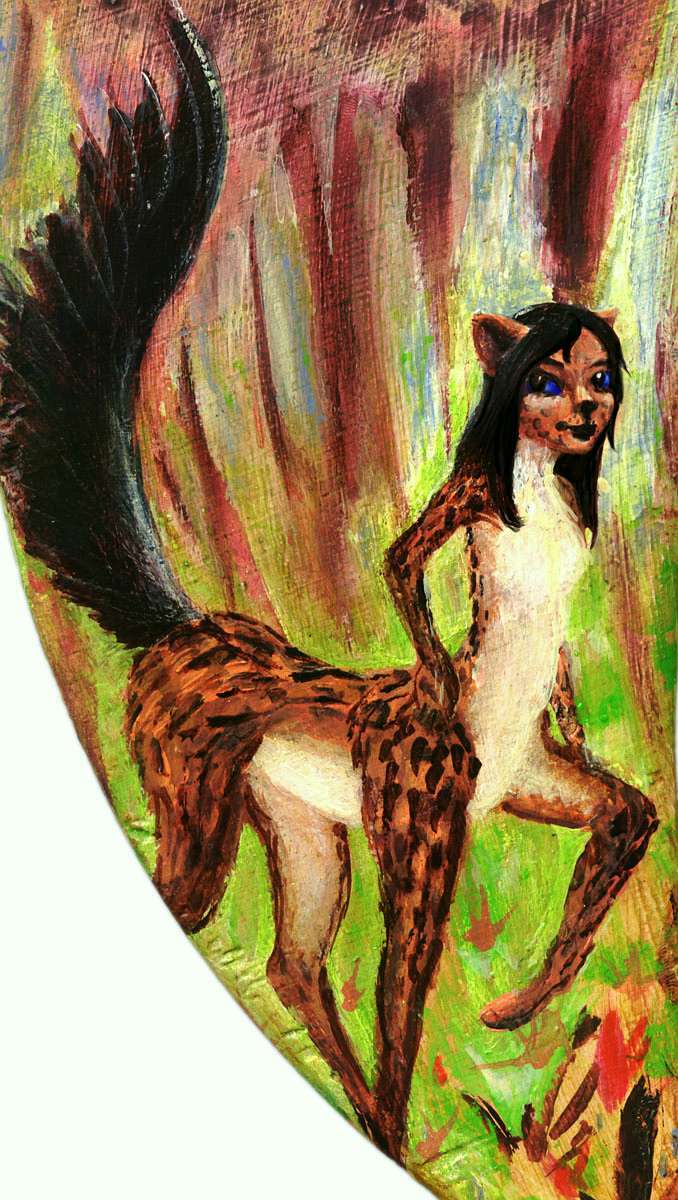
The dominant mammals will be leptaurs; as the name suggests, they're leopard-sized centauroid felines. They evolved on neighboring Atlantis. Easy-going and social, with dexterous hands, they developed language, tools... and boats. Not water-loving but quite able to swim, they've become the best sailors in this hemisphere. Populations here are nearly as dense as on Atlantis.
They won't be obligate carnivores like our cats; hunting is hard and dangerous, so strict carnivores live short lives--a teenage lion is old. So while our leptaurs have builds and pelts a little like Terran leopards, the name's purely descriptive; they're omnivores. And there's plenty of omni to vore! The brushy, patchy savanna and woods of southwest Atlantis have tropical fruit trees, berry patches, nuts, greens, seeds parchable in campfires, shallow lakes full of crayfish and turtles... invent nets and snare birds, invent the hook and line and catch fish... why hunt big game?
My guess is they'll develop tools more to keep from being big game themselves--such savanna will have both midsize pack predators and big solitary hunters.
(But then, I'm a contrarian about human evolution too--I suspect defense not offense was the drive behind human weapons innovation. Lunch is never vital; not being lunch is. And that's shaped us; our childhood fear of monsters echoes a very long developmental stage. "Ontogeny recapitulates phylogeny" not just fetally, but psychologically. And we haven't yet fully outgrown that phase! At least some of us. Weapons and the demonization of enemies in war both grow from the ancestral terror of being devoured more than from a lust to devour. That's shallower and more recent: mere Ice Age atavism, recalling a time when some humans became top predators and turned highly carnivorous. But for millions of years, not mere thousands, fire and crude stone weapons were defenses, and we were still mostly herbivorous.)
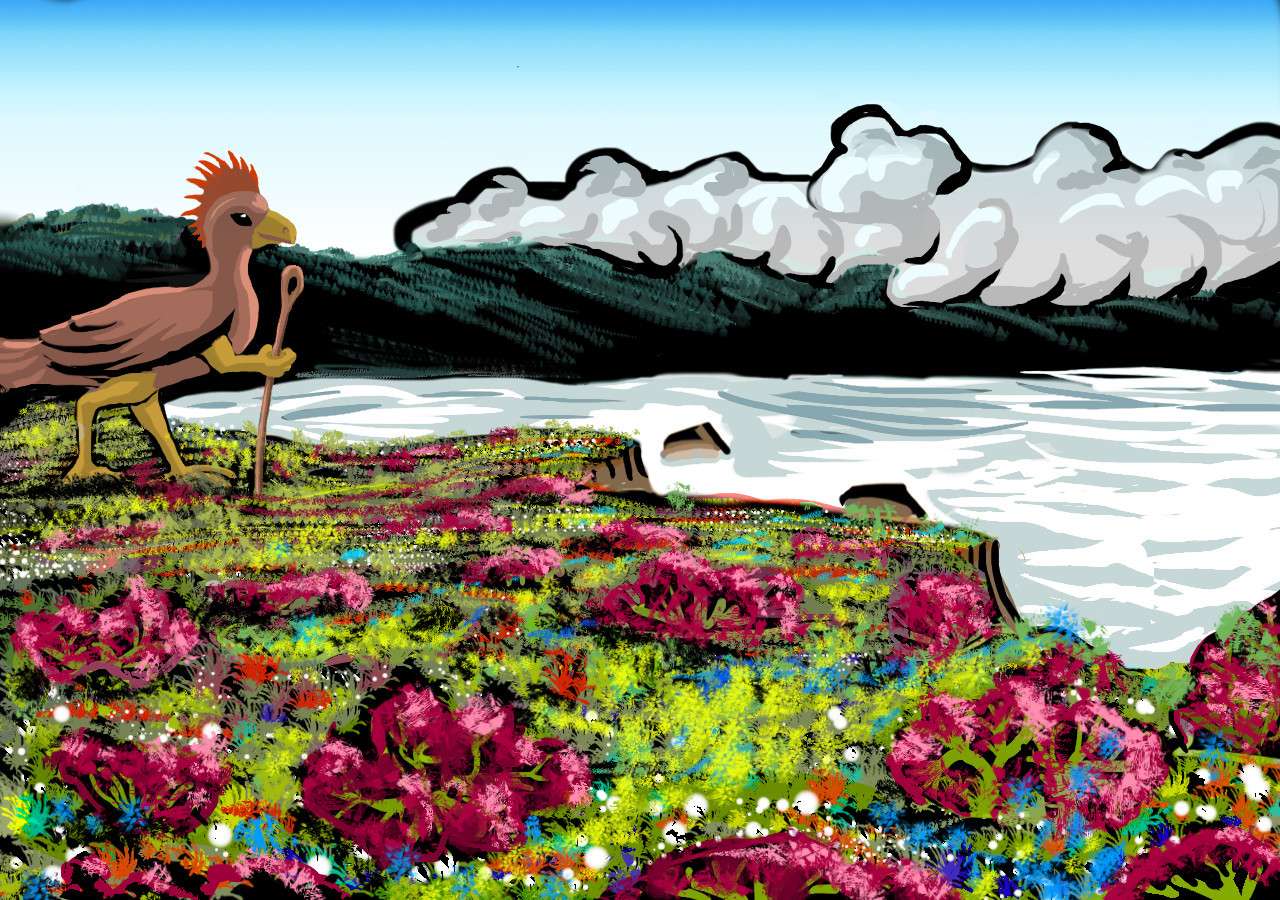
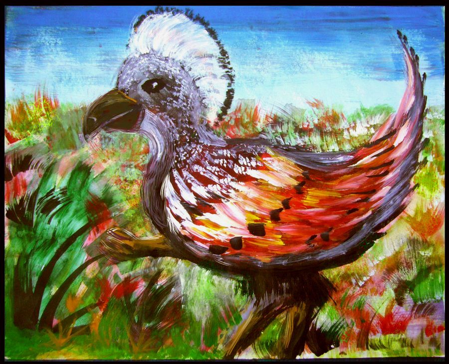
The dominant avians are large (nearly human-tall), flightless, beaky and feisty. They're called diatrymas, named for the similar extinct Terran bird found in the same general region. What makes the Abyssian model distinctive--and drove intelligence--is the forehands that all birds here have, a legacy of the Abyssian hexapodal body plan. Instead of centauroids as in mammals, feathered little near-velociraptors hunting the woods. But with tools and weapons--hands made tool use much easier. Brainsize grew. Tools and fire made plant-foods available; diatrymas turned omnivore. Villages grew. Bodies grew. Social complexity pushed brainsize even more.
Earth's big continents crawling with predators impose a strict weight-limit on most birds; they need to fly (or, like ostriches, rheas and emus, they specialize as runners, not thinkers). But lonely islands tended to evolve large flightless birds. Abyssia, continent-poor and island-rich, is inevitably richer in such large flightless birds, and Azorea, fertile but isolated, is ideal; diatrymas ruled the minicontinent.
The result? Modern diatrymas are at the fierce end of the flightless-bird spectrum, certainly--be polite, they have tempers! But they won't eat you. Weapons don't make you fiercer; they force restraint. The real hotheads dueled each other, or tried to fight leptaurs instead of trading. The survivors are civilized. And civil. Just be sure you are, too.
Do as the leptaurs do; move lazily, coax a bit, make a joke. If you've been around a parrot on a grumpy day, you know the routine. You'll be fine. Really, nine fingers is plenty.
 Unlike the leptaurs, who trade and settle all over this hemisphere, diatrymas are rare off Azorea. They can't fly and they don't like to sail. They have good biological reason to fear water. They sink. Most Abyssian birds, even flightless ones, retain hollow bones; but Diatrymas had a long prehistory as flightless hunters, and a snapped bone is a terrible liability. It's not surprising they sink; lots of creatures do. Among apes, only one species floats. Guess which. (This is why I believe the theory that our ancestors spent a long time fishing and clamming on some subtropical shore; our lack of fur and copious fat are adaptations to an amphibian lifestyle. We're freaks among apes.)
Anyway, that deep diatryma prehistory of fighting has precluded swimming, and prevented a diatrymish diaspora. Even the isles to the north and east have a different avian population--large seabirds we'll call auks. Also brainy, they're too big to fly more than a few yards; but unlike diatrymas, they're but sturdy swimmers with hollow bones and waterproof feathers. And why not? Their ancestors were fish-eaters. They still are, mostly.
Speaking of those isles...
Intro -
Mapping -
Holes -
Climate -
People -
The Northern Isles
-
North Azorea -
Midlands -
South -
Leone
The PORCUPINE ISLANDS stretch northwest, just off the top of the map (though they're in the orbital photos) up to 50° north, off what in our world is Ireland and Wales. I suspect the locals will think they're the northernmost land in the world, though they'd be wrong. It'll be a long time before they discover the Lena Islands. And when the Porcupinians finally do, and they describe that snow-adapted flora and fauna, the explorers will be called big liars...
It may partially be specism. The Porcupinians are themselves biologically odd: they're auks, neither quite fliers nor flightless--something between penguin and cormorant. Much smaller and more timid than the big, fierce mainland Diatrymas, the auks are divers who can fly short distances but are mainly fishers. Their semiaquatic roots sculpted them into sailors comfortable in the water, in the rain, in cold generally. As a result they've settled the cool, rainy islands all around northern Azorea (and have spread west to the isles off northern Atlantis, and east to the mysterious Greek Isles.
Ahem, yes, the Porcupines, not the Lenas, Atlantis, Greece, the kitchen sink... The Porcupines: picture Ireland before sheep. Low, rainy, cool, green. Few meadows--forest shore to shore, broken only by lakes, marshes and boggy meadows. Folks here may hunt and log those woods, but they mostly live on the coast and fish. Rich waters; a sunnier, easier, more spacious life than roaming dark forests or painfully clearing a sunny patch for a small farm.
The KINGS ISLANDS, running almost due west, are rugged--long, narrow ridges rising as much as 1500 m (5000'), thrusting into deep water, with dramatic cliffs in spots. The Kings are seismically quite active; this is a fracture zone full of strike-slip faults and upthrusts. Snow blankets the heights in winter--the only place in northern Azorea you'll see much snow. Rainy springs, splendid summers and falls, sunny but mild and maritime. Redwoods flourish in the bottomlands, pines on the slopes, meadows on the windy ridgetops. Again, most of the people here are auks.
The CHARCOT ISLANDS, corresponding to the lowest bits of our Bay of Biscay, are north and east of Iberia; the largest, Jovellanos, leads 300 km due east. Again, cool, rainy, wooded. Most winters are mild and snowless; the Charcots are low--much gentler than the Kings.
The GREEK ISLANDS: most Abyssians may not hear about it for generations, but the Basque fisherpeople of the Charcot Islands have quietly explored far to the east, where reefs corresponding to our Mediterranean Basin--the Medimarean Banks--stretch for thousands of kilometers. There--far off our map, far off anyone's map--are the Greek Islands, settled and kept secret by its Basque discoverers. Of course it's unlikely these particular Basques are human--more likely flightless birds--but given the climate, they'll be flightless birds who are clannish, fishy, drink a lot of good wine, and speak a tongue no one can make sense of. So they must be Basques. That's climatology for you!
IBERIA, by far the largest "isle of the north". Iberia's an integral part of the Azorean continental plate, but it's a shard cracked off by deep Horseshoe Strait (a fracture zone, like the Kings Island ridge). It's the largest island dominated by auks. If you can say auks dominate anything! Introverted and gentle by nature--Moomintrolls not Hemulens--they hold this rich land only because the strait's wide, cold and deep. And because the more aggressive diatrymas to the south are truly inept sailors.
Iberia is about the size of Spain, and due west of our own Iberian Peninsula. There are a few similarities--coastal ranges round a central plain--but more differences. This Iberian coast is convoluted; the hills are low and the plain lower still--not the central Spanish plateau but a basin half-drowned under upper and lower Lake Azore. It's rainier than Spain (and not only on the plain, Mr Higgins!)
The reason's simple: there's no Sahara to influence the region's climate; nor a gigantic cluster of continents upwind, like our Old World. Summers here are warm and winters mild, but this isn't a Mediterranean climate; it rains often, even in summer, fed by thousands of miles of ocean.
The AMPERE ISLANDS, off Iberia to the southeast, are like Corsica off southern France or the BaIearic Isles off Spain. An integral part of the Azorean plate. Low, fertile, rainy, and mild in climate--after all, we're no further north here than Athens or San Francisco.
The AZORES, off Iberia to the west and southwest--the southernmost auk lands. Nearly identical to our Azores (and surrounding them in an arc--our Azores are that deep blue hole between Graciosa and Pico). They're not as mountainous--not volcanoes rising from deep sea, but ridges rising in fault zones. Mild climate. Very pleasant places to live... except once every generation or two when a quake raises a tsunami. No matter how sheltered a cove looks, fishing villages are all built a few yards up the rocks, not on the beach.
Intro -
Mapping -
Holes -
Climate -
People -
Northern Isles -
Northern Azorea
-
Midlands -
South -
Leone
South of Horseshoe Strait lies a long strip of fertile rolling hills: Canaria. Warmer than Iberia--truly subtropical, with somewhat less rain but still quite green; woods and groves. The capes and isles along the west coast, around Plato Bay, are an exception; these, downwind of the central hills, are drier--quite Mediterranean. The west faces of ridges, catching the full heat of the afternoon sun, are often open meadows. So are many sea-bluffs, where lurid floral displays progress through a long spring--fluorescent yellow mustard, blue irises and orange poppies, white lilies, purple lupines, red paintbrush...
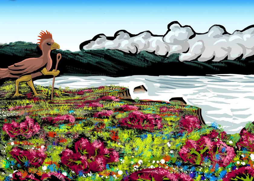
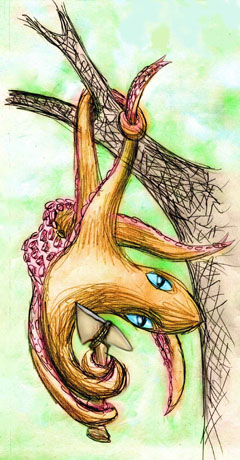
Diatryma on coastal bluff near Plato Bay, Azorea; based on print, 'Franklin Point', by Tom Killion
Further south, around Meteor Bay, the central hills are gentler: no barrier to storms, which sweep right across Canaria. Green from coast to coast! More Florida than Greece.
All this is Diatryma country. Be polite and they'll treat you right. Think of them as big, big ravens or parrots, though: feisty and nippy if insulted. As their beaks are the size of your head, you do not want to be nipped.
The Meteor Hills and their attendant chain of lakes are a natural divider between north and central Azorea--a natural Hadrian's Wall. Not high--500 meters to 1000 at most--but rugged and full of scarps from active faults.
Intro -
Mapping -
Holes -
Climate -
People -
Northern Isles -
North Azorea -
Midlands and Atlantis Range
-
South -
Leone
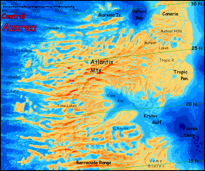
Central Azorea has spectacular lakes and fjords and islands, especially in the northwest. I apologize again for the name-shortage in this area; Northern Azorea, being off Europe and the Azores, is well-researched; this central region, less so. Lakes and islands hundreds of kilometers long (and this equally large ridges and troughs in our abyss) are as yet unnamed.
In the northeast, as we enter the region, we pass the Meteor Lakes, the first continent-spanning lakechain, but not the last...
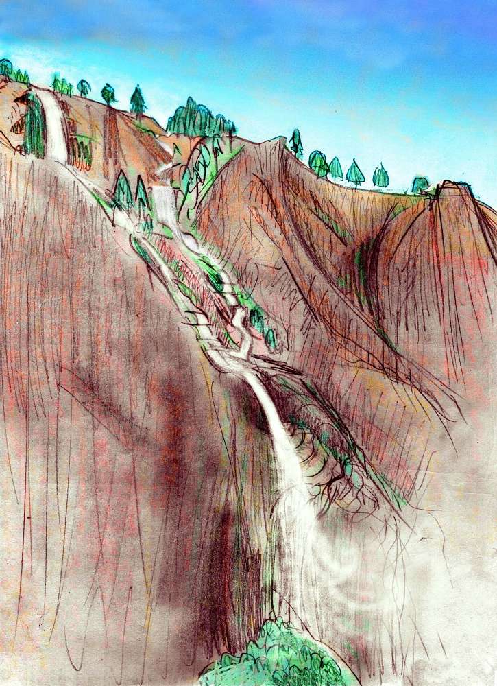
The Atlantis Range rises to over 1800 m (6000'). Wooded, rugged, with many parallel ridges, like the Appalachians or Brazil's coastal mountains. The highest ridges are somewhat west of center, but spurs, often steep ridges that subdivide fractally into knife-edged walls, wander all over central Azorea. A wildly dissected highland. Yet this dissection's mostly not erosion, which would lead to treelike structures. This labyrinth looks fractal, yet rectilinear!
What's happening here is that the spreading zone lurking in the Atlantic Sea to the west is squeezing Azorea, pushing it east, and corrugating it north-south; but the spreading's at different rates in each segment, leading to ridges, cliffs and long strait "fjords" running roughly east-west--the border-faults.
Along this coast and its islands, the strip of Mediterranean climate widens to its maximum, reaching inland hundreds of km to the mountain-spine. Pines above, but oak groves and grasslands below, turning gold in the long summer drought.
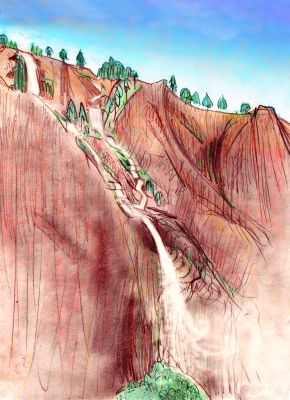
The red cliffs and fall sketched to the right are on the Colorado River--no, not named (like our river) for the red mud in it, but for the canyons associated with the Colorado Fracture Zone on the west face of the Atlantis Range, in its driest stretch. Faults and slippage are as relentless and effective a sculptor of cliffs and falls as ice is on Earth; there are many waterfalls in this scenic region.
This dry west coast is unusual for Azorea in another way; here the majority is neither the shy auks of the north nor the brassy diatrymas from the east; mammals are everywhere! They're leptaurs, from the neighboring continent of Atlantis: easy-going omnivorous feline centauroids native to savanna and desert, comfortable in these dry canyons and grassy hills in a way the native Azoreans aren't. They already had a habit of trading with their own continent's native flightless birds, the Titani, so they came to trade, settled in small numbers in many ports on Azorea's west coast... but here, they flourished in lands they liked and diatrymas didn't.
On Earth, such situations have led to endless wars--but here, rival groups proudly consider themselves different, but are the same species fighting over the same niche! Abyssians' deeper differences, in particular their very different climatic preferences, have led to less friction, not more. It's more profitable to welcome all settlers , and trade with them, and live in regions you prefer--hot, cold, wet, dry.
It's why, on the Peoples of Abyssia page, the ranges for intelligent species are so spotty and overlapping. Better for business.
East of the mountains it's vastly different: the diatryma heartland. Here a huge forest, hot and humid, covers Azorea's largest plain, the Tropic Plain. Yes, it straddles the Tropic of Cancer, but that's not the direct source of the name; our world's Tropic Seamount, and therefore Abyssia's Tropic Hole, lie just offshore.
To the west, the Mediterranean strip narrows but continues. The low orbital shot at left shows catches central Azorea near sunset, when the low, ruddy light shows off the full crazy fractality of the Atlantis Range--and its relative aridity. Meadows and cliffs are fiery gold in the sunset light, while the back side of the mountains are deep-shadowed forest.
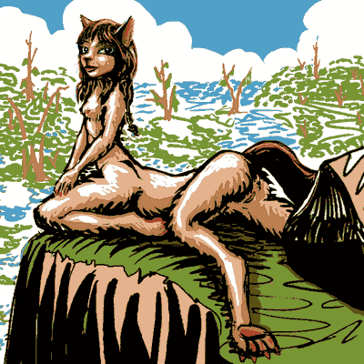
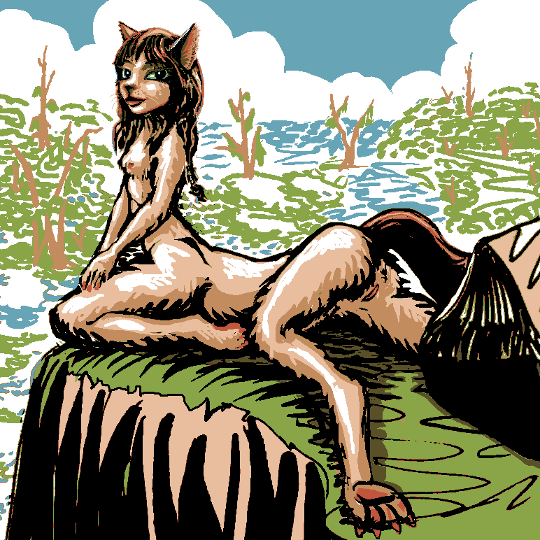
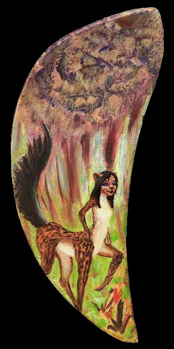
Leptaur above Barracuda Marshes, southern Azorea
|
Southeast: Kane Bay and Krylov Gulf have lower but still wildly fractal coasts, all capes and sounds. Another profusion of (fairly) straight lines and (almost) right angles unnatural to our eyes. But remember--these crazy ridges, canyons and basins exist on Earth too. They're just inverted--and hidden under three miles of black brine.
Next come the equally peculiar, artificial-looking regular ridges and basins of the Krylov Lakes and the similar Barracudas south of them. This is a Terran example of what on Venus is called tesselated terrain: regular tile-like patterns, the result of multiple forces squeezing or stretching land at strange angles. Here, unlike in the heart of the Atlantis Range, the basins between compression-ridges often drop below sea level, cupping salt sounds near the coasts and great freshwater lakes inland. From orbit they look like the tire tracks of a monster truck.
On the ground, this landscape is a web of long rocky swells and ridges, mostly wooded but with grassy outcroppings where the soil runs thin; these drop into swampy basins with heavily buttressed trees like our swamp cypress, marshy pools and sloughs, slowly deepening to lakes, spilling over low sills in a slow cascade to the sea.
Though it's wet country, the local population includes quite a few leptaurs; the strips of sunny, reedy open ground appeal to them. Not their native savanna, but grassland of a sort. "Bog Cats", the sophisticated port folk call them, disparagingly--like our Bayou Cajuns, they're looked down on as backward.
But a certain sort of individualist likes the swamp life--slow, patient fishing, not the bustle of the port cities.
Intro -
Mapping -
Holes -
Climate -
People -
Northern Isles -
North Azorea -
Midlands -
Southern Azorea
-
Leone
South of the great lake-zones, the land is lower, except for the Vema Hills and the long ridges of the Doldrums--never more than a mile high, and often just half that. This is monsoon country--hot and wet in summer, warm and dry in winter. The west coast is still the driest strip, with some savanna; but most of the south is forest.
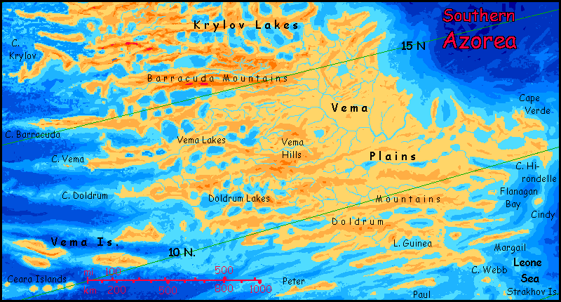 South of the Doldrum Range is the Guinea Coast. From Cape Vema to Cape Verde and along this southern shore, it's true rainforest; we're less than 10° north now. Green, green, green.
The long islands and capes around Doldrum Sound and Leone Deep, and offshore--Peter, Paul, Margail, and the rugged Vemas--are tropical gems. Rainforest to the waterline, luxuriant coral reefs offshore. The population's not dense, though; coastal fishing settlements of leptaurs mostly. Diatrymas don't like to sail, and the cats don't like the close, damp jungle.
Intro -
Mapping -
Holes -
Climate -
People -
Northern Isles -
North Azorea -
Midlands -
South -
The Leone Islands
These jagged, narrow equatorial islands, with ridges up to 3000 m (almost 10,000'--the tallest peaks for 5000 kilometers!) are the equivalent of our La Romanche Gap, a great gash in the Mid-Atlantic Ridge where the spreading zone jags abruptly east, creating the sharp (and matching) angular shapes of South America and West Africa. Inverted, the Gap becomes a rugged island larger than Java with long lean satellite islands like remoras round the big shark.
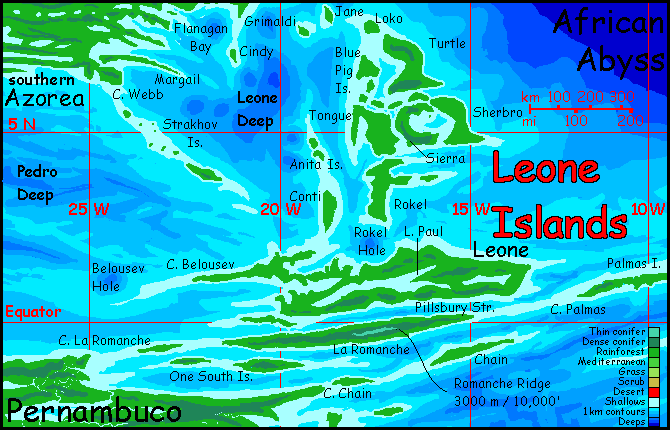
Like New Guinea, Leone's lowlands are steamy and difficult to get around in; the uplands, above the clouds are cooler and drier (and more scenic). Small in area, but quite pleasant, at least by human standards; though of course Abyssians, having evolved in a mostly tropical world, may find the lowland heat and humidity delightful and Romanche Ridge intolerably cold.
Who are these Abyssians? I'm not sure. I suspect the diatrymas from Azorea proper won't make it south to these islands unless another species ferries them. I'm not sure they'd like it; they're very big and fully feathered, both features retaining heat. In this muggy climate they might end up steamed chicken.
If Leone evolved its own large flightless bird, we have few models; the nearest geographical equivalent on Earth is the ostrich, a runner of the open plains. And not famed for intellect! A clever-handed, clever-minded ostrich still might evolve, but further south, on the open savannas of Angolia. But I just don't think such a plains creature could thrive in this green, horizonless tangle!
Maybe it won't be a bird at all. Though none of the three mammalian centauroids I've postulated seem well adapted either for climbing trees and enjoying endless rain...
Maybe it won't be vertebrates at all. What about six-legged tree-squid? At least, being quite amphibious, they won't mind the rain.
And they won't lose their grip, fall, and break a bone, either. No bones. Maybe they are a good fit.
The Leone Archipelago is just a gateway: to the east is lower but larger Guinea and beyond to the south is Angolia, bigger than Greenland (greener, too) while to the southwest is still larger Pernambuco. Since the Leone group seems more geographically linked to this central stretch of the Atlantis Rise, its full description will go on that page, not this.
When it's done. If it's ever done...
Whoever said God rested on the seventh day got that wrong. Worldbuilding is a workaholic thing.
 TOURS: this route snakes around Abyssia's major lands -
Lena Is. (brr!) -
Greek Is. -
Atlantis -
Azorea -
Cayman and Albatrosia -
Andean Is. -
Scotia Is. -
Morningtonia -
Agassiz -
South Pacifica -
East Pacifica -
Hawaiian Sea -
Pacifica Desert -
Filipinia -
Banda Is. -
Vityaz Archipelago -
Tasman Is. -
The Bight -
Whartonia -
Chagosia -
Somalia -
Mascarenia and Crozetia -
Weddellia -
Argentia -
Pernambuco -
Angolia -
Tristania -
Agulhas group
TOURS: this route snakes around Abyssia's major lands -
Lena Is. (brr!) -
Greek Is. -
Atlantis -
Azorea -
Cayman and Albatrosia -
Andean Is. -
Scotia Is. -
Morningtonia -
Agassiz -
South Pacifica -
East Pacifica -
Hawaiian Sea -
Pacifica Desert -
Filipinia -
Banda Is. -
Vityaz Archipelago -
Tasman Is. -
The Bight -
Whartonia -
Chagosia -
Somalia -
Mascarenia and Crozetia -
Weddellia -
Argentia -
Pernambuco -
Angolia -
Tristania -
Agulhas group
Abyssia's homepage - map - peoples - regional tours - names
LISTS AND LINKS: More worlds? Planetocopia! - dreams of other worlds - ecology - climate change - evolution - natural disasters - terraforming - sculptures and 3D art -
World Dream Bank homepage - Art gallery - New stuff - Introductory sampler, best dreams, best art - On dreamwork - Books
Indexes: Subject - Author - Date - Names - Places - Art media/styles
Titles: A - B - C - D - E - F - G - H - IJ - KL - M - NO - PQ - R - Sa-Sk - Sl-Sz - T - UV - WXYZ
Email: wdreamb@yahoo.com - Catalog of art, books, CDs - Behind the Curtain: FAQs, bio, site map - Kindred sites