World Dream Bank
home -
add a dream -
newest -
art gallery -
sampler -
dreams by
title,
subject,
author,
date,
places,
names
Abyssia:
Banda Archipelago
by Chris Wayan, 2011
for those lost in the tsunami; may their souls be reborn on Abyssia
Abyssia home - down to
map -
building Abyssia -
geology & geography -
critters & cultures -
the clash of names -
more worlds? Planetocopia!
Introduction
-
Trade & People -
Weber Island -
The Low Isles
Earth's deepest ocean is the Pacific, so it's no surprise that Abyssia's greatest landmasses are found on the Pacific Rise. On this great platform rides more than half the land in the world--Pacifica itself plus Agassiz, Filipinia, and Morningtonia. The first three have straits so narrow that the next continent is visible from a hilltop. Morningtonia is further out, but linked by a tightly packed island chain, again luring even primitive mariners across the narrow straits.
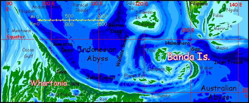
But around these four is a moat; to reach the rest of the world's scattered lands there are gaps of 500 km or more of open water. Of these barriers, the easiest to cross is probably here, from Filipinia over the Halmahera Gap to the Banda Archipelago, and from Banda, south over the Flores Gap to Whartonia and the lands corresponding to our Indian Ocean--and on round the African Abyss to Atlantis... that is, virtually all other land on Abyssia! Banda's the gateway between Pacifica and the rest of the world, just as Indonesia is a gateway for our world (a huge fraction of Earth's trade passes through the Strait of Malacca).
Banda would be important even if it had been barren--and it's not. The islands get around 3 meters of rain a year (120"+), so even the smallest islets overhang with trees right down to the tideline, like monster green mushrooms. On the larger islands, slow rivers wind through rich forests. Unlike the isles around Filipinia to the north, here the rains never fail and the dry season's a relative thing--and a relief when it comes. If it comes. Again, quite Indonesian...
Introduction -
Trade & People
-
Weber Island -
The Low Isles

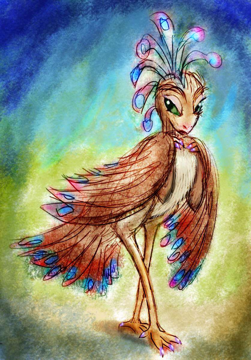
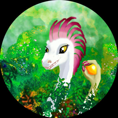
Nabiro, a showgirl in stage crest & wings; Port Flores, Banda
|
Fertility plus trade means the Bandas are both prosperous and cosmopolitan. Port Banda at the northern tip of Weber and Port Flores on western Solor are major cities by Abyssian standards. They'd seem technologically quaint to us (18th or early 19th Century, perhaps)--no powered vehicles, indeed not streets exactly; plankwalks and bridges for people, and canals for bulky loads. These are wet tropical towns, where even the buildings are just wood platforms and rattan walls and thatched roofs--great bird-nests or people-baskets, woven and replaced every few years after a bad typhoon.
Yet the people in these primitive cafes and theaters would seem futuristic--indeed galactic. You'll easily spot over a dozen species, mammalian and avian and possibly even molluscan--though that Nicobarian tree-squid in the corner, nursing a pink drink, is characteristically shy, and adept like all her people at color-and-pattern mimicry; you probably didn't even notice that rattan chair was sipping sherry. And had tentacles.
Mind where you sit. In Port Flores, Tom Waits can sing "The Piano Has Been Drinking" and mean it literally.
Here's a sketch of Nabiro, a cabaret dancer from the same club, just off shift, tired after a long duet. She hasn't yet taken off her wings (her real ones underneath are of course vestigial; at 1.4m head to toe, she's far too big to get off the ground). On Abyssia, avian cabaret dancers get risqué by putting things on not taking them off. Plucked chickens aren't a thrill; but brightly colored crests and feathers generally imply seasonal sexiness to big birds; and wings turn everyone on, mammal and bird alike. The fantasy of flight! What could be sexier? Consider: it works in Vegas even on furless, featherless apes.
Dancers and feathers; it's just a thing.
You may have noticed Nabiro doesn't have a beak, but lips; more like the face of a saurian or mammal than a Terran bird. And it's not a superficial oddity: she has teeth behind those lips. A lot of Abyssian birds do.
Why? Well, why not? Plenty of winged dinosaurs had teeth.
But on Earth, the impact at Chicxulub was so devastating, most dinosaurs built to eat fresh food died in the 'impact winter' or the hot period after--the pulverized limestone raised CO2, trapping heat. Only a few small fliers made it through the climate swings--presumably by eating seeds, the longest-lasting food, and the only thing left after the carrion from the dead giants was all gone. That took tough, seed-cracking beaks. Their descendants, once they diversified, couldn't reverse-engineer a saurian jaw and teeth.
But was the extinction here on Abyssia as severe? I'm skeptical. On Abyssia Chicxulub isn't coastal, but deep sea. Way less dust blocking sunlight, and what there is is pulverized seafloor--basalt--way lower in carbon, so it won't raise CO2 levels much. A worldwide tsunami, and firestorms, and blast waves, yes, killing most land animals and all the large ones--but a wider variety of small species might have survived these briefer scourges.
There's a rival theory that what really killed off the dinosaurs were the huge eruptions of the Deccan Traps--climate swings, CO2, sulfur (acid rain!) ash, lead, and mercury. Suppose this theory is correct; then Abyssia still comes out ahead. Here, the Deccan is miles deep; just another abyssal basalt plain. Deep-sea eruptions just don't do as much damage.
So either way... with smaller climate swings, more small Abyssian birds and mammals survived. Thus, some modern Abyssian birds could have dinosaurian traits lost to Earth birds.
And those beakless faces have had eons to further evolve. Facial muscles, lips, cheek pouches, external ears?
So I've drawn many Abyssian birds with earthlike, beaked faces, but others... not so much.
Introduction -
Trade & People -
Weber Island
-
The Low Isles
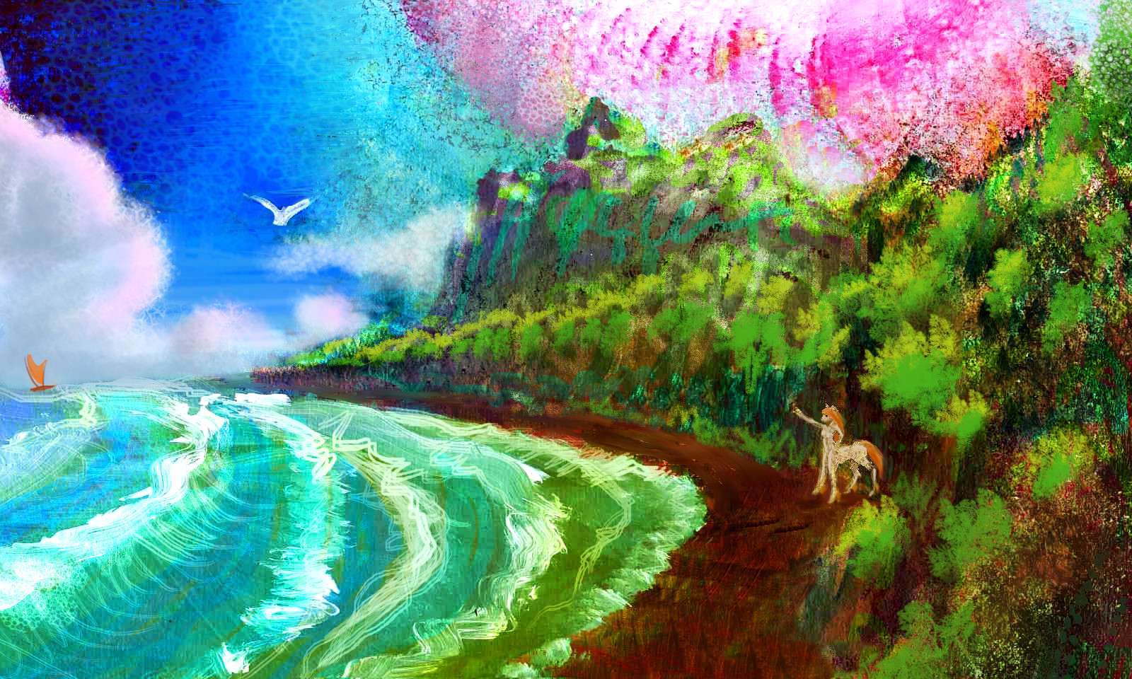
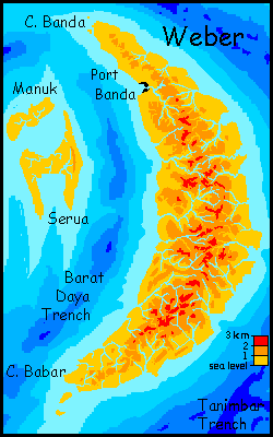
Weber, the easternmost of the Bandas, is the biggest too, if just barely--some 450 km long and up to 125 wide (280 by 75 mi). Weber is rugged--an arc or wedge of volcanic mountains rising to 2600 m high (8,500'). On a map it looks much like nearby Yap or the Mariana Peninsula, so you might expect a similar spectacle: ice-capped mountains above palm beaches--an Abyssian Hawaii.
But in fact, most of Weber is rainforest or cloudforest, almost to the summits. The mountains are a bit lower, and we're just 5-10° from the equator here; they don't often thrust above the cloud-sea. More like the rainy, uninhabited hearts of Kauai or Moorea than New Guinea! Few live in the highlands; with the humidity a permanent 100%, things just won't dry out. Mold, ugh!
Nor does Weber have a true dry side, like Hawaii's Big Island; this close to the equator, stormtracks just swing round during the year, alternating which side to drench. Still, the lowlands on both coasts dry out a bit between rains, and do each have a relative dry season--meaning occasional rain instead of monthly typhoons!
The claustrophobic forest does thin out a little on a small stretch of the southwest coast, on the inside of the great arc; here the mountains partly block most storms. It's still wooded and quite lush, just not dense rainforest; an occasional clearing where you might just see the sun.
Weber's population is mostly coastal and lowland; fishing towns, or orchards growing the tropical fruits nuts and greens that feed Port Banda and its hordes of sailors and tourists, up by the northern point.

Black-sand beach on western Weber in the Banda Archipelago
Introduction -
Trade & People -
Weber Island -
The Low Isles
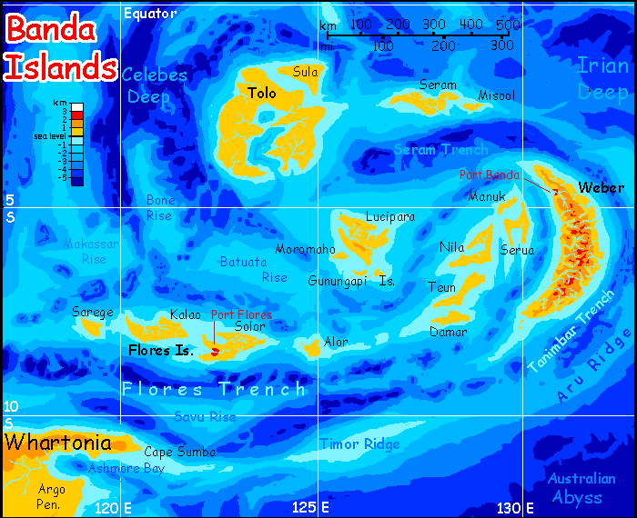
The central and western Bandas are gentle--on the surface at least. Not underwater, though!--a twisted maze of ridges and trenches. Vertical coral-gardens don't hug the shores, as they do in parts of our Bahamas, but sail out for a few hours through shallow reefs, and the shelf drops away into indigo deeps.
Why are there islands here at all? You wouldn't think there was room for much abyssal floor amid Indonesia's countless islands, but the region is crumpling under severe tectonic pressure. Invert it on Abyssia, and the abysses become islands! Our Australian Plate may be a deep abyss now, but it's still racing north, crashing into the Pacific Plate. The Bandas, and the trenches flanking them, are the crash zone--crust forced up as well as under.
Tolo is the largest Low Isle in area, just about matching Weber. It's curiously flat for such a tortured region. Well, flat except for the 70-meter trees! A 400-kilometer chunk of Sumatran or Papuan lowland jungle broken up by a winding tongue of sea, miles deep in spots--a chain of antivolcanoes, those mysterious Abyssian features where the crust puckers deep inwards. I suspect the reefs of Tolo's Tongue, while they look colorful and rich, are less diverse because the water's poisoned, on occasion, by releases of carbon dioxide from these deep holes.
On land, the trees aren't hurt by such blasts--they don't breathe oxygen--but animal life can suffer. Natives of the Tolan Tongue, not being stupid, live in treehouses--CO2 clouds are heavier than air, and only gas the understory. Most Tolans live on the outer coasts where the problem--if you call sudden, invisible death a mere "problem"--is rare. And winds are stronger here, shredding the deadly plumes. The only real port is here, in the sheltered strait between Sula and Tolo.
Lucipara and its attendant islands are much like Tolo without its little flatulence problem--low and flat, with rainforests, coral beaches and wide rich reefs. These chunks of crust are probably shards of a once-large land broken up and mostly swallowed by trenches, just as the equivalent abysses on Earth are probably remnants of a once much wider sea.
The lesser Bandas, like Flores, are straightforward chains paralleling trenches--as in our Indonesia. At least the eastern half! On maps of Indonesia not showing water depth, merely coastlines, the archipelago looks pretty evenly spread out. But biologically there's a sharp divide: Wallace's Line. West of it lie shallows that become land during ice ages, when sea levels drop. East of the Line is deep sea; individual islands may link during low water, but they never join the mainland.
On Abyssia, Wallace's Line is an instantly visible border. East of it, the platforms of the Bandas aren't all high enough to be land; many like Timor, Batuata, Makassar and Bone end up as reefs or guyots. But at least land is possible. At Wallace's Line, around 117° east, a long underwater scarp drops away, and the Bandas just end. To the west is deep, unbroken blue: the first tongue of the Eurafrasian Ocean, largest and deepest on Abyssia, and that's saying a lot. The Everest Deep is nearly 14 km down--over 45,000'.
Port Flores is perched on the rim of the abyss. But then, isn't civilization always?
 TOURS: this route snakes around Abyssia's major lands -
Lena Is. (brr!) -
Greek Is. -
Atlantis -
Azorea -
Cayman and Albatrosia -
Andean Is. -
Scotia Is. -
Morningtonia -
Agassiz -
South Pacifica -
East Pacifica -
Hawaiian Sea -
Pacifica Desert -
Filipinia -
Banda Is. -
Vityaz Archipelago -
Tasman Is. -
The Bight -
Whartonia -
Chagosia -
Somalia -
Mascarenia and Crozetia -
Weddellia -
Argentia -
Pernambuco -
Angolia -
Tristania -
Agulhas group
TOURS: this route snakes around Abyssia's major lands -
Lena Is. (brr!) -
Greek Is. -
Atlantis -
Azorea -
Cayman and Albatrosia -
Andean Is. -
Scotia Is. -
Morningtonia -
Agassiz -
South Pacifica -
East Pacifica -
Hawaiian Sea -
Pacifica Desert -
Filipinia -
Banda Is. -
Vityaz Archipelago -
Tasman Is. -
The Bight -
Whartonia -
Chagosia -
Somalia -
Mascarenia and Crozetia -
Weddellia -
Argentia -
Pernambuco -
Angolia -
Tristania -
Agulhas group
Abyssia's homepage - map - peoples - regional tours - names
LISTS AND LINKS: More worlds? Planetocopia! - dreams of other worlds - ecology - climate change - evolution - natural disasters - terraforming - sculptures and 3D art -
World Dream Bank homepage - Art gallery - New stuff - Introductory sampler, best dreams, best art - On dreamwork - Books
Indexes: Subject - Author - Date - Names - Places - Art media/styles
Titles: A - B - C - D - E - F - G - H - IJ - KL - M - NO - PQ - R - Sa-Sk - Sl-Sz - T - UV - WXYZ
Email: wdreamb@yahoo.com - Catalog of art, books, CDs - Behind the Curtain: FAQs, bio, site map - Kindred sites