World Dream Bank
home -
add a dream -
newest -
art gallery -
sampler -
dreams by
title,
subject,
author,
date,
places,
names
Abyssia: Cayman and Albatrosia
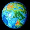
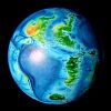
by Chris Wayan, 2010
for William Beebe and Otis Barton, first voyagers into the abyss
Abyssia home - down to
map -
building Abyssia -
geology & geography -
critters & cultures -
the clash of names -
more worlds? Planetocopia!
Introduction
-
Cayman -
Albatrosia -
Western Isles -
Chicxulub -
Malpelo -
Cortés -
People
This page briefly tours these two great islands west of Atlantis. Both islands are quite narrow, never more than 200 km wide (125 mi), and often less than 50 (30 mi); but each is well over 1000 km long.
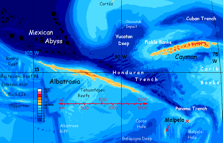 CAYMAN is the upside-down equivalent of our Cayman Trench in the Caribbean. It's larger than Java, smaller than England. Cayman is very rugged, with several peaks up to 2600 m (8300'), rivaling the Puerto Rico Range on the Atlantean mainland to the east; high enough for a little snow in winter, even at this balmy latitude. The climate's distinctly drier than our Caribbean, since upwind of Cayman lies Atlantis's southwestern desert.
ALBATROSIA, to the southwest, is much lower; this island corresponds to the Middle American Trench, part of our Pacific Rim trench system, like the Andean Islands to the south. Since it's beyond the Atlantean rainshadow (storms can blow in from two oceans) it's noticeably rainier than Cayman.
MALPELO and CORTÉS are two much smaller islands, distant from Cayman and Albatrosia, but I've put them here because they're even farther from anything else.

Introduction -
Cayman
-
Albatrosia -
Western Isles -
Chicxulub -
Malpelo -
Cortés -
People
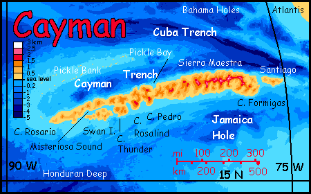
This island off Atlantis, just south of the Cuba Trench, is 1200 km (750 mi) long, as big as our Cuba. But very different--much of Cuba's low, but Cayman's a rugged, twisted mass of ridges, geologically complex; quakes are common. So are volcanoes.
The rugged peaks of the Sierra Maestra rise up to 2600 m (8300'), third highest range in the hemisphere. The Sierra is an extension of the Puerto Rico Range on the Atlantean mainland; and like it, is high enough for some snow in winter. In the east and center, the high country is broken, sky-islands dissected by deep twisting canyons.
Past Cape Rosalind and around Misteriosa Sound, Cayman's spine sags and frays even more, into freestanding peaks (some still nearly 2 km high) lapped by sounds or low alluvial plains. A bit more Cuban (with Swan Island standing in for the Isle of Youth I guess), but still... not much.
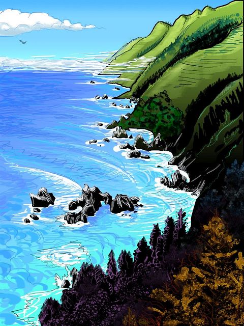
Steep southeast coast of Cayman, faux print by Wayan 2017
after 'McWay Rocks, Big Sur' (2013), a print by Tom Killion
|
The climate's drier than our Caribbean, too, since Atlantis's southwestern deserts lie upwind. No hurricanes come from the east! Still, storms from the north and south give most of the island adequate rain. And the Sierra Maestra Range is high enough to snag clouds and rain, even from weaker weatherfronts. They'd cast a rainshadow to the southwest if Cayman had a southwest, but the narrow island angles so the long south coast is sunny yet catches light rains much of the year, rather like Honolulu: rainbows every afternoon. The north shore is shady, misty and lush green.
Unlike most of Abyssia, where coastal water's shallow and full of coral reefs, Cayman's shores drop off sharply, especially in the north and east. Coastal cliffs are common. Both north and south coasts rise from trenches 5 km deep, though the northern, the Cayman Trench, is better defined--a straight gash of midnight blue severing Cayman from Pickle Bank.
Pickle Bank, a broad reef complex the size of Taiwan, is more typical of Abyssian coastal waters--a shallow turquoise tangle of coral reefs. Fine fishing, but the locals will have to return to Cayman for fresh water; the Banks have a few slender islets built up enough for palm trees, but none with pools or springs.
Introduction -
Cayman -
Albatrosia
-
Western Isles -
Chicxulub -
Malpelo -
Cortés -
People
Albatrosia is over 1000 km west of Cayman, some 2000 west of Atlantis. Albatrosia is much lower than Cayman; this long slender island corresponds to the Middle American Trench, part of our Pacific Rim trench system, like the Andean Islands to the south. Since it's beyond the Atlantean rainshadow (storms can blow in from two oceans) it's also noticeably rainier than Cayman.
Albatrosia is quite narrow, never more than 100 km wide, and often less than 50 (60-30 mi). Yet it's fully 2000 km long (1250 mi). It's named for the Albatross Ridge, a scarp system running thousands of km south from the long island's northwest end. It was that or name it Middle American Island. Clumsy.
The southwest coast is fairly dry. The central hills, from 1000 to 1700 m high (33-5400') block much rain from the east. Globally, deserts are rare. Except for Pacifica, Abyssia's scattered lands are maritime, and most mountains are too low to cast strong rainshadows. That's true here: the southwest shore of Albatrosia is in a high pressure zone prone to deserts--if the land were continental or directly downwind of a desert. But thousands of miles of ocean generate rain, even if winds are weak much of the year. So this shore has savanna and open woods of little trees that bloom in a good year and turn brown in a bad. Still, there are creeks from the hills; enough for irrigation. A tiny strip of dry Mediterranean climate, basically.
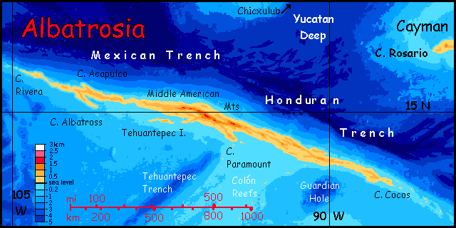
Maybe the land is a bit grudging, but the sea is rich; off Cape Paramount, a huge arc of reefs and shallows curves south then east for 2000 km : the Colón Reefs, larger than our Great Barrier Reef. Not the largest on Abyssia, a world abounding in coral; but big.
The east coast, in contrast, is lush throughout. Storms off the American Sea roll in unobstructed. Few coral reefs here, for this shore drops off quickly into very deep water indeed: the Mexican Trench, some 7-8 km deep; its lowest point, Orizaba Hole, is nearly 11 km down, one of the deepest spots in the hemisphere, rivaling our own Mariana Trench.
Though albatrosses certainly frequent the island (its central ridge, running across the prevailing winds, creates a ridable updraft 2000 km long, a bird-freeway) its name comes not directly from great-winged birds but from Albatross Rift, running south from its western tip (left side of the map); the trench's east wall is an impressive underwater escarpment at least a kilometer high. In our world, it's the equally little-known (because equally hidden undersea) but geologically spectacular Albatross Ridge (best seen in the companion globe to Abyssia, Siphonia).
Introduction -
Cayman -
Albatrosia -
Western Isles
-
Chicxulub -
Malpelo -
Cortés -
People
Southwest of Albatrosia are some islands I didn't detect until 2022. After revising the position of Malpelo, I started looking closer at other seas round Albatrosia. In the region north of our Clipperton Island rise the Mathematician Seamounts and then seamounts named for Mexican painters (with the shameful exception of Frida Kahlo). These mountains become troughs and holes on Abyssia, of course; but my newest maps show that the Orozco, O'Gorman and Siqueiros fracture zones, which arc across this territory, have trenches deeper than I thought; inverted, many will support coral reefs on Abyssia, and several, islands--Clipperton, just northeast of our island, the three Euclid Islands to its northwest, and probably Einstein Atoll.
All these are mere islets--Clipperton, the biggest, is 16 km long, 8 wide (5x10 mi)--but they're fortunate in location: halfway between the Dowd Islands off Pacifica, and Albatrosia. This increases the chance this long crossing between hemispheres will have been discovered early; Albatrosia may not be so isolated. Indeed these warm, rainy, fertile islets may support lively port cities, rather like Sala in the southern hemisphere (whose position I've also had to revise in light of better maps).
Introduction -
Cayman -
Albatrosia -
Western Isles -
Chicxulub
-
Malpelo -
Cortés -
People
Abyssia is Earth; its mass and orbit are the same. So, therefore, is its history of impacts. About 66 million years ago, a huge comet or asteroid struck our Yucatan Peninsula, near the present town of Chicxulub. It hit Abyssia too--but here, Chicxulub is deep, featureless sea, several hundred kilometers northeast of Albatrosia. The impact spread a cloud of vaporized basalt and steam, but not limestone (carbon-rich). After the firestorm, shockwave and worldwide tsunami, the darkness was briefer--months not years--and the climate less destabilized (on Earth, the pulverized limestone and steam reacted to form carbon dioxide... causing a worldwide heatwave after the worldwide winter).
There's a rival theory that what really killed off the dinosaurs were the huge eruptions of the Deccan Traps--climate swings, CO2, sulfur (acid rain!) ash, lead, and mercury. Suppose this theory is correct; then Abyssia still comes out ahead. Here, the Deccan is miles deep; just another basalt plain. Deep-sea eruptions just don't do as much damage.
So either way... with smaller climate swings, more small Abyssian birds and mammals survived. Some bird lineages have teeth, feathered snouts not beaks, and other traits our birds lost in the holocaust.
You may have noticed how whimsical my Abyssian avians are. Yes, some of that's bad cartooning, and some's because I'm about as scientifically rigorous as a dodo, but some is quite serious--I think so many birds survived the Abyssian Chicxulub extinction that some will have traits and expressions we'd see as dinosaurian and/or even vaguely mammalian.
Introduction -
Cayman -
Albatrosia -
Western Isles -
Chicxulub -
Malpelo
-
Cortés -
People
Malpelo Island is far southeast of Albatrosia, midway between C. Cocos and the Andean Archipelago, the big southern sister(s) of Albatrosia. Reefs link Malpelo to both; they're all part of the same Pacific Rim trench/ridge complex. Its equivalent on Earth is a small arcuate trench south of Panama.
Malpelo is perhaps 75 km long and 25 wide (45 by 15 mi); it's close to the equator, rainy most of the year, and covered in rich rainforest. Yeah, our world's closest equivalent, the Galapagos, are pretty dry; but they're in the rainshadow of the Andes, a little item absent on Abyssia. A closer analogy would be our Panama.
So go ahead and land, stock up on fruit and fresh water, all you mariners! And possibly rum, too, in those coastal towns.
Though you might lose a few things to pirates. This is a Caribbean isle, after all. Just... there aren't any more. "Island of the Caribbean"? Just doesn't have the same ring...
Poor old Malpelo! Single for life.
I was bluffing, you know. My atlases all disagree on this little trench's depth and shape, so the geography is quite cloudy. Some of my sources would have me create a mere coral bank here, or at most a reef--no true land at all; some, a low, C-shaped atoll; a few, more substantial mountains. Oh well, those hills are probably wrapped in endlessly drizzling clouds, anyway. As bad as cartographic doubt, and wetter, too. Drip drip drip, those cloud-forests. Ugh. Stick to getting robbed in the coastal towns, they're sunnier.
And yes, Malpelo means Bad Hair--presumably the discoverer of the nearby Terran islet (a bit southeast of this Abyssian Malpelo, but close) was having a bad-hair day--all that brine, I guess--"water, water everywhere, and never a drop to rinse" as Coleridge so quaintly observed.
Update: 2019
Half a dozen regional bathymetric maps now seem to concur that the arc of trenches just north of Malpelo wouldn't be deep enough for an Abyssian island--just coral banks a few hundred meters down, most likely. On the other hand one high-resolution map with firmer numbers for specific soundings confirms a deep little trench (about 5600m or 18,400') around three degrees west-SOUTHwest of our Malpelo, not NORTHwest; that's enough for an Abyssian Malpelo with cloud-forested central hills 700m high (half a mile). But it's a couple degrees south of its old position, right off the old map--I had to expand it. Tedious work.
Still, Malpelo exists! Yay! What a... relief!
Sorry. Planetology pun. Vertical relief. Emotional relief. Oh, never mind...
Anyway, I just wanted you to know I don't make up these details of my variant Earths that disagree with Google Maps or GEBCO's lower-resolution world maps. They smooth things out. I felt bothered by the disagreements on my known maps, spent a couple hours looking at a whole mess of conflicting maps online before I hit confirmation on a map with firm soundings. It pays to research (caution: second pun coming) in depth.
Introduction -
Cayman -
Albatrosia -
Western Isles -
Chicxulub -
Malpelo -
Cortés -
People
Update: 2023
A National Geographic oceanic atlas by Sylvia Earle reports an unexpected deep point in the middle of the Gulf of Mexico, at over 5200 meters; well below the 4000s of previous maps. This creates a small island like Malpelo; no more than 300 meters high (1000') with, probably, gentle topography and an uncertain extent, though it will be small. I've dubbed it Cortés after the nearest named feature in our world, Cortés Canyon, 50 km north.
No profound impact (that loaded word, since Chicxulub Crater lurks just to the south) on Abyssian history; the islet just ties the Cayman Archipelago closer to Atlantis, with one more way-stop for sailors between Atlantis and southeast Pacifica.
Introduction -
Cayman -
Albatrosia -
Western Isles -
Chicxulub -
Malpelo -
Cortés -
People
Biologically as well as geologically, Cayman and Albatrosia are quite distinct.
Cayman, near Atlantis, has biological variations on Atlantean themes; it's not that far offshore, and its mountains offer habitat much like Atlantis's western mountains, savannas and deserts, heartland of the leptaurs. Cayman will definitely be settled by these amiable, omnivorous, catlike people. They may not love to swim (at least in the sea; all that salt drying in your fur afterward gives you whole-body malpelo), but they're perfectly competent swimmers--and sailors.
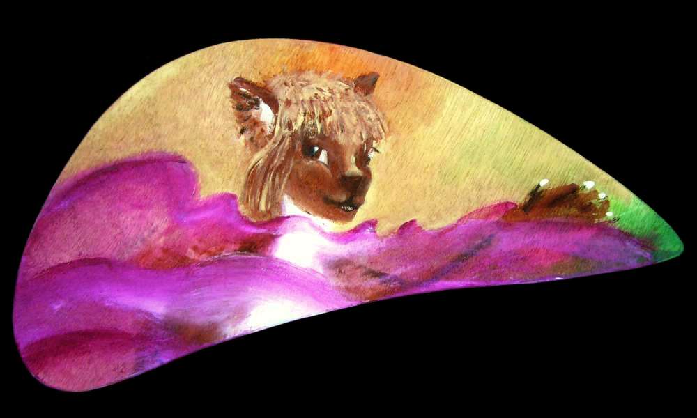
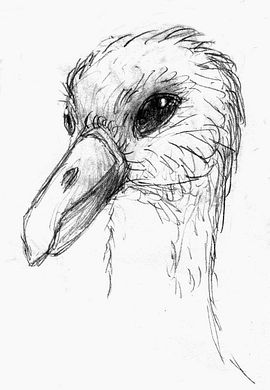
An Albatrosian: 1.5m, 15 kg
|
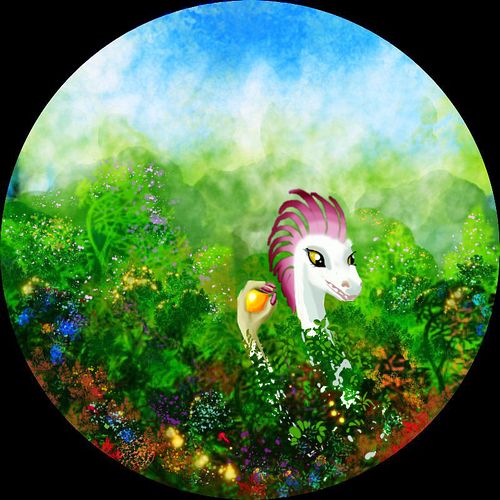
But Albatrosia's a very different story. Deep isolation has made Albatrosia (like the Andean Archipelago to the south) a laboratory for speciation. The best Terran analogies are New Zealand and Madagascar. Albatrosia is a largely avian world, dominated by huge flightless birds, all of them endemic. Large land animals from other continents could not swim or drift here; it's simply too far. Storm-blown birds, though... and without large land predators, flightlessness is likely to result. And as on Madagascar and New Zealand, gigantism. If a bird doesn't need to stay light, why not grow big?
Now, two factors have so far blocked Terran birds from achieving civilization despite high intelligence and socialization: small size, and lack of hands. Flight limits absolute size, and thus brainweight. Wings are specialized limbs, hand-feet are awkward, and so are beaks.
But the big flightless species that tend to evolve on the most isolated of Abyssia's scattered landmasses lack both these limitations:
- HANDS: "Bird" means something a little different on Abyssia. Avians, like most vertebrates here, are variants on a basic six-limbed body plan; it's insects that have four. Thus, nearly all birds have small (but not vestigial) forelimbs tucked under wings or folded over their breasts; limbs typically evolved to snatch insects, groom feathers, pick fruit, carry nesting materials... and wield tools.
- SIZE: On Albatrosia, with no large land mammals--no predators at all to flee--flightless, giant albatrosses evolved. Now even Terran albatrosses, restricted in size by the harsh demands of long-distance flight, are highly intelligent and extremely long-lived. They were ideal candidates for personhood--quite as good as apes. Indeed, they may rival apes in intelligence, despite their small size. On Albatrosia, with that restriction taken off, and hands to act and build, directed by that intelligence...
It may be that deepwater ships never discover Albatrosia; instead, it's quite possible that ships from Albatrosia discover... the world.
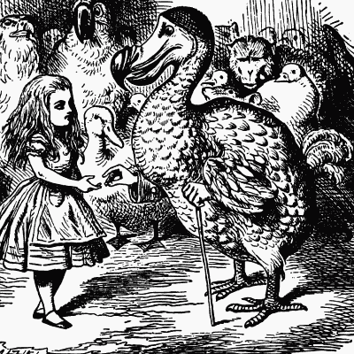
Not that this should surprise you. Abyssia, by its premise, is an upside-down, looking-glass, Alice sort of place. The dodo shall inherit the earth.
 TOURS: this route snakes around Abyssia's major lands -
Lena Is. (brr!) -
Greek Is. -
Atlantis -
Azorea -
Cayman and Albatrosia -
Andean Is. -
Scotia Is. -
Morningtonia -
Agassiz -
South Pacifica -
East Pacifica -
Hawaiian Sea -
Pacifica Desert -
Filipinia -
Banda Is. -
Vityaz Archipelago -
Tasman Is. -
The Bight -
Whartonia -
Chagosia -
Somalia -
Mascarenia and Crozetia -
Weddellia -
Argentia -
Pernambuco -
Angolia -
Tristania -
Agulhas group
TOURS: this route snakes around Abyssia's major lands -
Lena Is. (brr!) -
Greek Is. -
Atlantis -
Azorea -
Cayman and Albatrosia -
Andean Is. -
Scotia Is. -
Morningtonia -
Agassiz -
South Pacifica -
East Pacifica -
Hawaiian Sea -
Pacifica Desert -
Filipinia -
Banda Is. -
Vityaz Archipelago -
Tasman Is. -
The Bight -
Whartonia -
Chagosia -
Somalia -
Mascarenia and Crozetia -
Weddellia -
Argentia -
Pernambuco -
Angolia -
Tristania -
Agulhas group
Abyssia's homepage - map - peoples - regional tours - names
LISTS AND LINKS: More worlds? Planetocopia! - dreams of other worlds - ecology - climate change - evolution - natural disasters - terraforming - sculptures and 3D art -
World Dream Bank homepage - Art gallery - New stuff - Introductory sampler, best dreams, best art - On dreamwork - Books
Indexes: Subject - Author - Date - Names - Places - Art media/styles
Titles: A - B - C - D - E - F - G - H - IJ - KL - M - NO - PQ - R - Sa-Sk - Sl-Sz - T - UV - WXYZ
Email: wdreamb@yahoo.com - Catalog of art, books, CDs - Behind the Curtain: FAQs, bio, site map - Kindred sites


