World Dream Bank
home -
add a dream -
newest -
art gallery -
sampler -
dreams by
title,
subject,
author,
date,
places,
names
Abyssia: Chagosia
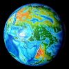
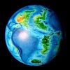
by Chris Wayan, 2011
For the Chagosians robbed of your island, Diego Garcia; may the US
let you go home. I've tried to give you the homeland you deserve.
Abyssia home - down to
map -
building Abyssia -
geology & geography -
critters & cultures -
the clash of names -
more worlds? Planetocopia!
Introduction
-
North -
South -
Osborn -
Western Isles -
People -
Coastlines & Names
Our Indian ocean floor is complex, but very little of that complexity breaks the surface. Madagascar, the great arc of reefs from the Seychelles to Réunion, the long line of the Laccadive and Maldive Islands south from India, the chilly islands of the Kerguelen plateau off Antarctica, a few random islets... and you're done. The sea hides the great Y-shaped rift ranges, the intricate fracture systems branching off the rifts, and the almost Andean mountains called the Ninety East Ridge.
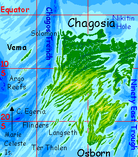
On Abyssia, the Indian Ocean becomes a rise, of course, but not a great continent called India (or Indiana?) That forking rift zone splits the Indian rise into three platforms supporting nine major landmasses. Six are big islands comparable to Madagascar--Agulhas, Bouvetia and Natalia in the southwest, central Mascarenia and Crozetia, and equatorial Somalia. Three surely qualify as continents: Weddellia in the south, Whartonia in the east (by far the largest--nearly Australian), and between Whartonia and Somalia, Chagosia. It's within shouting distance of Whartonia: just over the narrow channel of the Ninety East Trough.
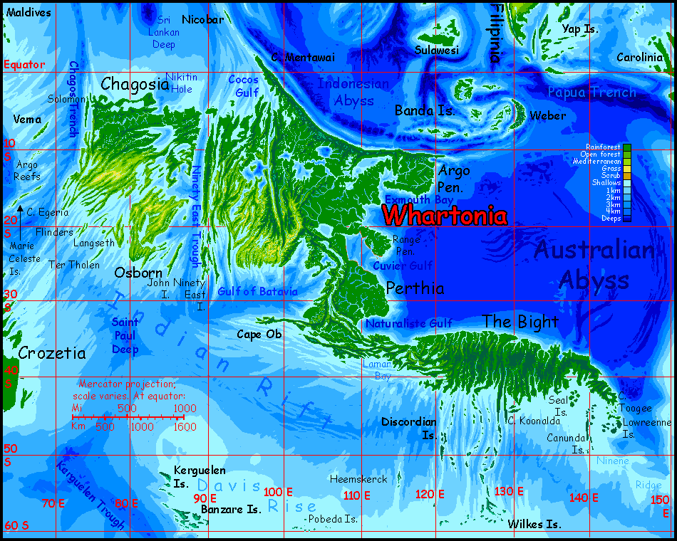
Geologically, Chagosia is a squarish chunk of crust about the size of Greenland, being steadily pushed north by the Indian Rift to the south. Strike-slip faults bound Chagosia: the Chagos Trench to the west and the Ninetyeast Trough to the east (one guess which meridian that's on. Yes! You win!) In the north the land slips smoothly into shallow water, except for Nikitin Deep and Viaud Trough. In the south, Chagosia rises from the depths of the Indian Rift in long ridges. Fracture zones, smaller than Chagos or Ninetyeast but big enough to create great islands and sounds, happen each few hundred kilometers: the Egeria, Flinders, Ter Tholen, Langseth, and Brenner.
Chagosia has three climatic belts, though with no sharp boundaries. The north is equatorial rainforest. Further south, the rains gradually become seasonal; first a belt of monsoon forest, more open than the north; and then wide patches of savanna. It resembles coastal Australia, and the heartland would probably resemble the Outback too--if Chagosia had a heartland. But the land's small and mostly maritime, broken up by deep sounds and lakes, with hills so low they can't block even weak fronts off the oceans. But most of Chagosia is rolling or flat. The hills are even lower than Australia's Barrier Range: in the east and the heartland, most heights are under 500 m (1600'); the western coastal hills do rise to 1000-1500 m high (3300-5000').
Since sea winds can penetrate much further inland than in Australia, only the midwestern plains feel truly continental. And only the southern part of these plains are dry: Flinders Veldt. The north is rainy.
To sum up: north Chagosia? Plant heaven. South Chagosia? Animal heaven. Or at least a very nice African game park.
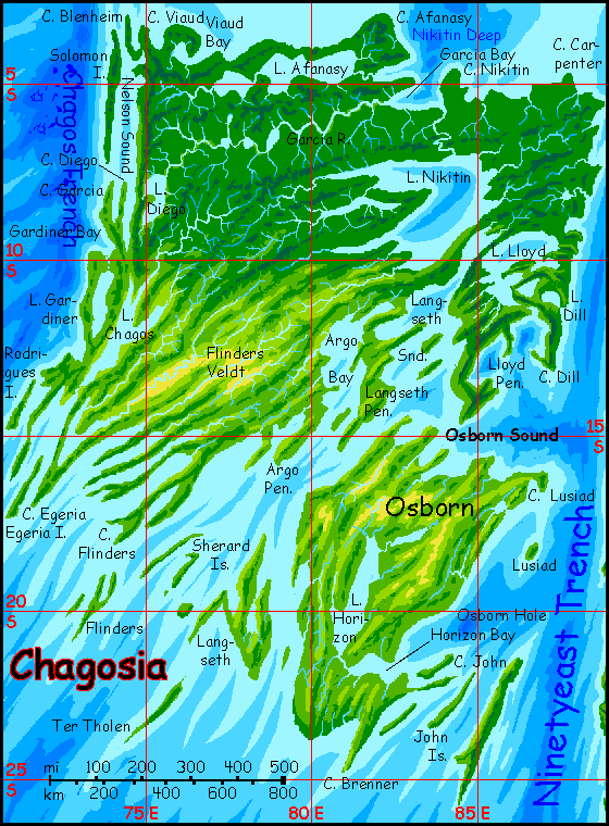
The south coast and its attendant islands are still low, but more dramatic--an endless sequence of capes, islands and straight "fjords". These are caused by fracture zones of a sort more typically found flanking the Atlantis Rift, in Atlantis, Azorea, Pernambuco or Angolia. The Indian Rift has less of this, and on Earth not an inch of it breaks the surface--not even close. On Chagosia, it does; capes and isles up to 500 km (300 mi) long and often cliff-walled, trail off into the Rift.
The southeast is a great island called Osborn, cut off by a narrow strait. It's climatically similar to Chagosia's south coast--a patchwork of woods and savanna. Inland, away from Lake Horizon, there are savannas much like Flinders Veldt, though more broken up than on the mainland.
Intro -
North
-
South -
Osborn -
Western Isles -
People -
Names
The north is unbroken rainforest. As in Amazonia, these woods transpire nearly as much water as they absorb, and anything they keep, the Great Lakes readily recharge. Lakes Afanasy, Nikitin and Lloyd are as big as North America's Great Lakes (in Nikitin's case, as big as two or three). And the climate's hot; much more water evaporates off them. A rainless month is rare up here.
But the rains aren't as heavy as on, say, Somalia or Guinea. The reason: Chagosia's downwind of the larger and more mountainous continent of Whartonia. The winds are drier. And by the time storms hit Chagosia, they've weakened by traveling over all that land; few full-on typhoons.
Still, it's rainy and green. Dense woods. Only in the south, well away from the equator, do the woods start to open a bit.
Intro -
North -
South
-
Osborn -
Western Isles -
People -
Names
In the southwest Chagosia gets almost African--at times, inland, almost Sahelian. Trees clump in groves and cling to rivers, but in between are broad dry savannas. It doesn't always take sky-piercing peaks to cast a rainshadow! At 20° north or south, mere hills can.
Still, this isn't Australia. The many sounds keep the west relatively maritime in climate; even the heart of Flinders Veldt is golden grassland, not red desert. Africa, not Australia.
Big nomadic herds of centauroid grazers here, and centauroid hunter-gatherers. And huge ostrichy flightless birds, also with small forehands aiding in foraging--and making tool use easy. Are any of them intelligent? Possibly more than one species; since they all have hands, they can imitate any tool-use they see. These species may all push each other into a long spiral of tool-use and brain-growth.
The far west is cut off by the low Chagos Range. The north shore is tropical and wet, but rains grow steadily more seasonal to the south; even so, Cape Rodrigues gets fogs and winter drizzle as well as some summer thunderstorms. Grassy slopes and wooded heights; never as hot and dry as Flinders Veldt. It's just too maritime; all that water is a huge thermal anchor. The weather varies from warm to... warm.
Intro -
North -
South -
Osborn
-
Western Isles -
People -
Coastlines & Names
Southeastern Chagosia is a great island called Osborn, cut off by a narrow strait. It's climatically similar to the mainland's south coast--a patchwork of woods and savanna. Inland, away from the influence of huge Lake Horizon, there are many savannas, broken by wooded hills. If you could merge all these grassy valleys, they'd be nearly as big as Flinders Veldt on the mainland. Large herds of grazers, all short-range nomads: up into the green hills in summer, down to the warmer drier veldt in winter.
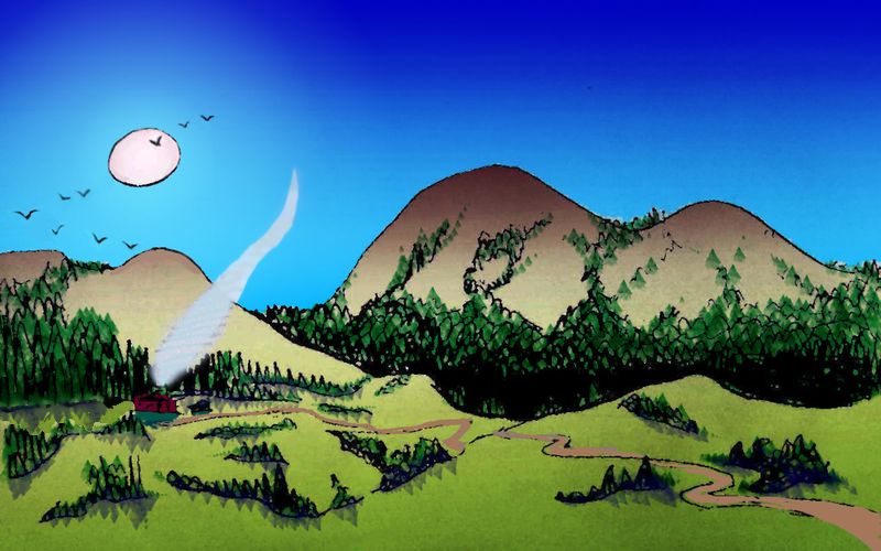
Farm, night; north of Lake Horizon, Osborn Island off Chagosia
The southern half of the island, especially Brenner Peninsula, and the outer islands like John, Langseth, Ter Tholen and Flinders, are generally rainier and more wooded. But it's not a simple picture--the region's a confusing patchwork of microclimates ranging from verdant forest to prairie and dry rocky scrub. It all depends on an island's topography, and on how much open water's upwind. Northwestern slopes face the hot afternoon sun, and are downwind to the few rains. Southeast slopes catch the most rain. Low islands don't snag much rain; craggy ones do better. Isles further out resemble Polynesia more; close in, Whartonia's landmass upwind has a drying, Australian effect.
As a group, these isles are quite livable and very scenic--splinters of crust new-born from the Indian Rift to the south. Seacliffs, high ridges and occasional volcanoes...
Introduction -
North -
South -
Osborn -
Vema, Argo, Marie Celeste
-
People -
Coastlines & Names
Vema, off Chagosia's west coast, is a rugged narrow island nearly 300 km long (about 190 mi), with a distinct wet and dry side. The southeast shore isn't quite as sheer as Kauai's Na Pali Coast; but it is steep, craggy, and verdant. The northwest is equally rugged but much drier, like Kauai's Waimea Canyon--raw red gorges below the misty green peaks of Vema's spine. But not one Waimea--dozens of gorges along a 200 km stretch of coast.
Why so dry? We're only 8 degrees from the equator, after all. But Vema's central ridges are never less than a km high and occasionally reach two (3300-6600'). And quite by geological chance this backbone stretches directly across the prevailing winds. The crags snag all but scraps of every storm. So the southeast blooms--at the expense of the canyon coast.
I expect Vema to be a port of call on the way to the next minicontinent/mega-island to the west, Somalia. Well, more accurately, the last continent--west and north of Somalia are thousands of kilometers of islandless ocean. So it may be a bit isolated, and Vema a minor port indeed.
The Argo Reefs are uncertain--atlases vary. At best, this diagonal ridge, so much like a lesser Vema, is a chain of coral atolls a few hundred km long--with no land even ten meters above sea level. At worst Argo may be just one or two atolls, or a mere tablemount where coral gardens thrive but never break the surface--smashed back by storm-cycloids whenever it gets close. Hard to be sure.
UPDATE: in 2019, I found a more accurate map of the region and found the next fracture zone south of Argo, the Marie Celeste, looks deeper--not as deep as Vema, but deep enough to create, on Abyssia, an island chain stretching southwest-to-northeast; most likely three isles, each a low ridge a few kilometers wide and a few dozen long, linked by extensive coral reefs. At the latitude of Hawaii, the islands are mantled in tropical forest, dense on the hills, open on the less rainy coasts.
Naturally, given the name's spooky history--the Marie Celeste was a boat whose crew all inexplicably vanished--the archipelago has no native intelligent life; though it's the logical place for Abyssia's equivalent of the Dodo to evolve, that shy, naïve people evolved instead on Vema, well to the north; and they've never spread here. Lovely islands, no people. Unless of course they're invisible, or trapped in a parallel dimension, or whatever explanation you favor for the Marie Celeste incident.
Introduction -
North -
South -
Osborn -
Western Isles -
Peoples
-
Coastlines & Names
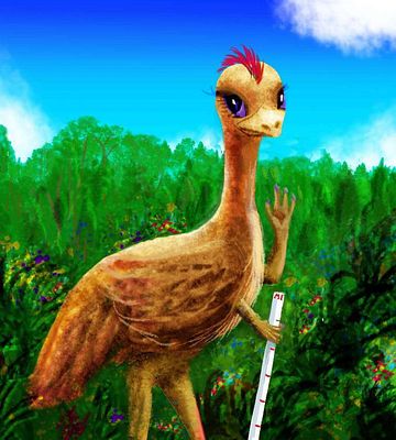
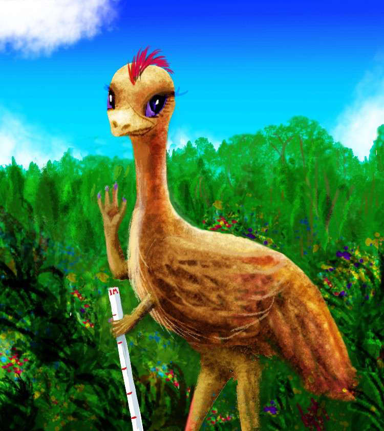
A Chagosian emu; short neck, big head.
|
Four intelligent life-forms dominate Chagosia.
EMU
In the south, a native bird, the Emu, an ostrich-like runner of the savanna in the southwest, who, as they developed tools, spread through the opener woods all over the south and west. They feel claustrophobic in the dense forests of the north and east coast, though.
That's not to say the emu are irrational; they faced doglike pack-predators on the ancestral savanna, and before developing spears they ran, at tremendous speeds. Or kicked--an emu kicks like a ninja kangaroo. But because they evolved in a big land with real predators, not a safe little island like many of Abyssia's flightless birds, emu get nervous in woods. Things can jump on you!
Before you mock, consider hardwired human phobias: of snakes, spiders, the dark...
EQUI
Much of the southwestern savanna has emu villages with large minorities of equi. This mammal native to distant Agassiz likes savanna--not a common ecosystem on Abyssia, so equi sailors have settled wherever the've found big horizons. Despite appearances, their worldview has much in common with the emu.

A gracile (heat-adapted) Chagosian equa at sunset
|
On Earth, if two human tribes both wanted the grasslands, they'd probably fight over it. But Abyssia lacks big continents, big predators or Ice Ages (in which the only food available for long periods was meat); most intelligent species are herbivores or leaning-that-way omnivores, who often evolved without large predators; like island species on Earth, they tend to trust strangers. The equi are unaggressive, rather cheerful folk who just moved in, found work, made friends, added their crops to the gardens, and... just got along.
Not every eq or emu is happy living in mixed villages; but hybrid towns do better, and they've slowly predominated. The mixed population has a wider range of mental and physical abilities, far wider than the merely cultural or racial differences humans mean when they say "diversity." Any Abyssian set down in one of our cities would have a different word for us: "Orashna." Literally, 'one-shaped', 'monomorphic'.
But really, what it means is 'boring'.
LEPTAURS
In port towns, the mix is enriched by another non-native mammal: leptaurs. These natives of Atlantis sail, settle and trade all over this hemisphere. The locals are have adapted to the heat, looking skinny, short-pelted and rangy even by leptaur standards, always more cheetah than leopard. Many subspecies around Abyssia sport showy manes like humans or male lions, but not Chagosians; it's just too hot.
As a result Chagosian leptaurs look smaller-headed than other races, though it isn't so. Not all leptaurs here have the look; plenty of the cats you'll see are traders and sailors from cooler lands, with stockier builds, longer fur and manes. But be aware that the scrawny-looking ones don't have mange or fleas, they're just fine, not contagious, thanks so much for asking...
In other words, you've just been rude.
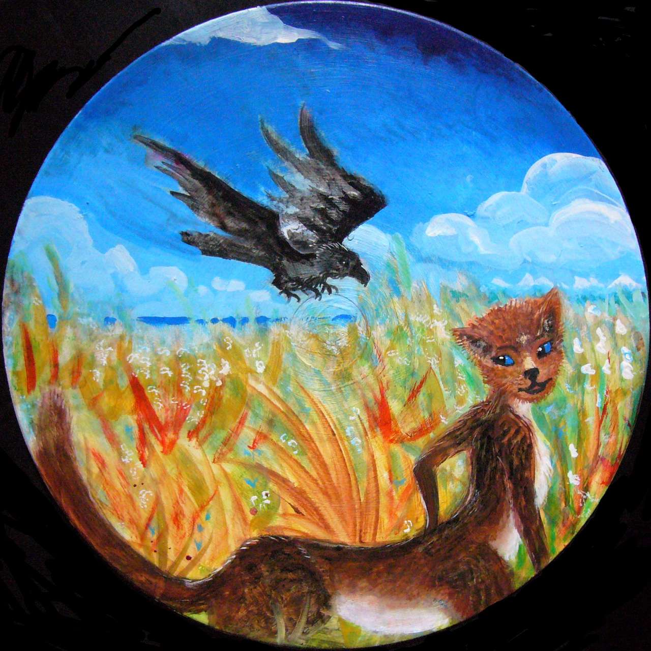
The illustration below shows a typical Chagosian leptaur hunting and fishing in a marsh (there are a LOT of marshes in this wet, low-lying land) with a pet raven. Just as intelligent as on Earth--that is, at least as clever as a chimp--Abyssian ravens make and use tools constantly; after all, they have small, dexterous, dedicated hands. No awkward hopping around or staring crosseyed at that thing in your beak! The fact there are more than a dozen species of undeniable people on Abyssia has distracted me from describing the pool of intelligent animals for those dozen-plus to arise from; a hundred or more may be on a par with our apes.
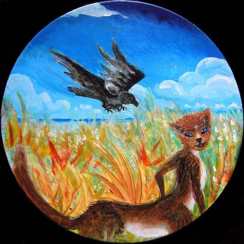
Leptaur with hunting raven
|
|
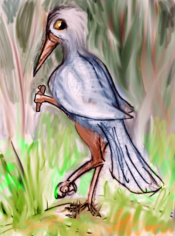
Chagosian kasowar
|
KASOWAR
In the more densely forested north, emus and equi are joined by another flightless bird native to the continents to the east: the kasowar. These are tall, thin flightless birds who evolved in the dense forests of equatorial Pacifica; they've spread out through the Banda Islands and the jungles of northern Whartonia. This is the edge of their range, though you'll meet kasowar sailors and traders in port cities to the west. As long as it's not too cold!
Kasowars have big sharp beaks and formidable claws on their feet. They're not persistently aggressive, but if startled, they'll lash out. Their preference for fight over flight is a direct result of their roots in a continental rainforest with good-size predators. In the woods, something will jump on you. Running's no use. There's always a damn tree in the way. Instead, you turn and teach that predator a lesson. You don't keep fighting--you want that predator to survive to teach its cubs. You just make your point--that you have them. Sharp points to be avoided.
So a kasowar will only slash you once. No need to worry at all. Really.
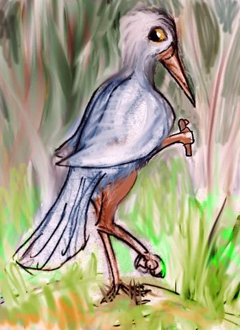
DODO
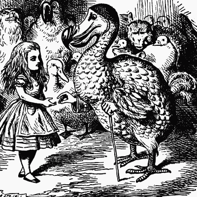
Dodo & Alice, by John Tenniel, Alice in Wonderland
|
There's one more intelligent flightless bird native to Greater Chagosia: the Dodo. But it is, and always has been, endemic to the Isle of Vema. Dodos are flightless birds nearly a meter tall, with small forearms they tuck under their stumpy wings when not in use. Dodos walk clumsily but swim well. Like penguins, they use their wings as propeller-blades.
Dodos are famously unaggressive and trusting--traits arising from their evolution and long isolation on a small, fertile island with no land predators at all. Like penguins, they understand the sea is a hungry, hazardous place... but they just can't believe land animals could be trouble! On Earth those traits doomed our dodos... when humans sailors came along.
On Abyssia, not quite so: the two species who sail these waters are omnivores, but neither is as fierce as humans--after all, they evolved in a world where even the simplest creatures can toss rocks and spears at you. You trade with other tool-users; those who pick fights or hunt creatures anywhere near your own size get weeded out over time. So neither the equi (who tilt toward herbivorous anyway) nor even leptaurs (who do eat plenty of meat), when they discovered these peaceful primitives, would go so far as to eat them. Today most Chagosians (of all species) seem rather protective of dodos; they're a sort of mascot or symbol of the region.
That's not to say there aren't subtler kinds of predation. Sailors offered dodos junky glass beads in exchange for Authentic Dodo Carvings, of course. You'll find those for sale in every port on the West Coast from Blenheim and Port Salomon down to Diego and Gardiner Bay.
Some are even genuine. About the same fraction of those on display as the fraction of Chagosians who are genuine dodos.
In short: equi and leptaurs, like humans, will prey on a naïve species, if sufficiently tempted.
It's just not the dodos. It's you.
Introduction -
North -
South -
Osborn -
Western Isles -
People -
Coastlines & Names
We tend to think of the abyss as a featureless muddy plain. The truth is that every new sonar sweep reveals more complexity; it's quite jagged down there. The fjordlike bays serrating the shores of Chagosia are the result of huge fracture zones. Lacy, crazy coasts like these repeat all over the planet--you can see why I've been slow to finish the relief and painting of this globe! Earth has a few of the features I've here called "mazes" (see a close-up map of southern Chile's fjords!) but ours are mostly ice-gouged. Abyssia's aren't.
The closest analogy would probably be basin-and-range country, where land gets squeezed upward and dropped in blocks and splinters, rather than valleys getting carved by running water. For example, Mount Whitney drops 3300 meters to the Owens Valley, which rises 2800 more to the Panamint Range, which drops 3500 more into Death Valley. Flood this washboard terrain 1200 meters deep (4000') and it'd look a bit Abyssian.
Only on Abyssia, hundreds of great splinters and tilted blocks are sliding, jostling, rising, dropping. Of course they're all here on Earth too, but miles down, where their struggle's unseen. On Abyssia it happens near sea level where it really shows--even if much of the action is still underwater.
So Chagosia's low altitude doesn't always mean it's gentle. This is young, raw crust full of scarps, ridges and canyons--it's just that many are still underwater. But not all. South Chagosia, especially, is jagged country--an endless procession of cliffy heads, deep sounds, islands and shoals, as is Whartonia across deep Ninety East Trench.
Much of the abyss, even today, is poorly mapped; so shorelines on Abyssia aren't always certain. The Indian Ocean has been less studied than, say, the North Atlantic or around Hawaii. Some areas, notably Madagascar and the coasts of Australia, have fine resolution and named features; most areas are so-so. Still, the Indian Rift, winding and forking between the nine lands, has bold relief. The result? I'm pretty confident of Chagos's coastlines and landforms, especially in the south; but less confident of inland topography. The broad patterns of hills and valleys are probably right, but details are guesswork.
Names are in short supply, and my sources sometimes disagree--though not as badly as in the southeast Pacific or southern Atlantic. In such places Abyssian names may be based on a distant Earth feature. For on Earth, a seamount or islet often gives its name to a nearby fracture zone--and these zones can stretch 2-3000 kilometers! So on Abyssia, the name may crop up on a peninsula or sound a whole continent away. And many atlases ignore the lesser fracture zones, so names here can look like thousand-mile longitude errors.
Fortunately, such displacement is less extreme around the Indian Rise, because fracture zones here are shorter and curve more than in the Atlantic--an effect of the curved and forked rift itself, I'm sure. Still, some of Chagos's names are borrowed from features hundred of kilometers away. Just not thousands.
Though some of the names may seem strange, they're based on real ones on Earth. Judgment calls, yes, a few of them desperate--but the names are not arbitrary, any more than the landforms are.
There are a few exceptions. Chagosia's lakes are generally modest, unnoticed, unnamed rises on Earth; many, like Lakes Nikitin and Afanasy, are named for nearby larger rises that merely form holes on Abyssia. Can't waste those scarce names!
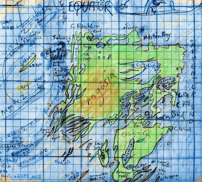
Osborn Sound, Island and Hole deserve disambiguation (my favorite Wikipedian word). In our Indian Ocean, Osborn Plateau (the equivalent of Chagosia's Osborn Sound) was named long ago for Sherard Osborne; nearby Osborn Seamount (Chagosia's Osborn Hole) was more recently named for John Osborn. And there were so few other named features in the region! So my first sketches of Chagosia peppered the southeast with a horde of Osborns--capes, lakes, bays, straits, islands, holes, you name it. I've tried to avoid that in the final version, instead bestowing their first names on nearby flocks of islands, and using the names of ships that mapped the area, like Argo, Lusiad and Horizon. My apologies to purists.
 TOURS: this route snakes around Abyssia's major lands -
Lena Is. (brr!) -
Greek Is. -
Atlantis -
Azorea -
Cayman and Albatrosia -
Andean Is. -
Scotia Is. -
Morningtonia -
Agassiz -
South Pacifica -
East Pacifica -
Hawaiian Sea -
Pacifica Desert -
Filipinia -
Banda Is. -
Vityaz Archipelago -
Tasman Is. -
The Bight -
Whartonia -
Chagosia -
Somalia -
Mascarenia and Crozetia -
Weddellia -
Argentia -
Pernambuco -
Angolia -
Tristania -
Agulhas group
TOURS: this route snakes around Abyssia's major lands -
Lena Is. (brr!) -
Greek Is. -
Atlantis -
Azorea -
Cayman and Albatrosia -
Andean Is. -
Scotia Is. -
Morningtonia -
Agassiz -
South Pacifica -
East Pacifica -
Hawaiian Sea -
Pacifica Desert -
Filipinia -
Banda Is. -
Vityaz Archipelago -
Tasman Is. -
The Bight -
Whartonia -
Chagosia -
Somalia -
Mascarenia and Crozetia -
Weddellia -
Argentia -
Pernambuco -
Angolia -
Tristania -
Agulhas group
Abyssia's homepage - map - peoples - regional tours - names
LISTS AND LINKS: More worlds? Planetocopia! - dreams of other worlds - ecology - climate change - evolution - natural disasters - terraforming - sculptures and 3D art -
World Dream Bank homepage - Art gallery - New stuff - Introductory sampler, best dreams, best art - On dreamwork - Books
Indexes: Subject - Author - Date - Names - Places - Art media/styles
Titles: A - B - C - D - E - F - G - H - IJ - KL - M - NO - PQ - R - Sa-Sk - Sl-Sz - T - UV - WXYZ
Email: wdreamb@yahoo.com - Catalog of art, books, CDs - Behind the Curtain: FAQs, bio, site map - Kindred sites