Abyssia: Mascarenia and Crozetia

by Chris Wayan, 2007
for Captain Crozet
Abyssia home - down to map - building Abyssia - geology & geography - critters & cultures - the clash of names - more worlds? Planetocopia!
Abyssia: Mascarenia and Crozetia
by Chris Wayan, 2007
for Captain Crozet
Abyssia home - down to map - building Abyssia - geology & geography - critters & cultures - the clash of names - more worlds? Planetocopia!
Overview - Mascarenia - Melville Sound - Crozetia - Sapmer - Naming - People
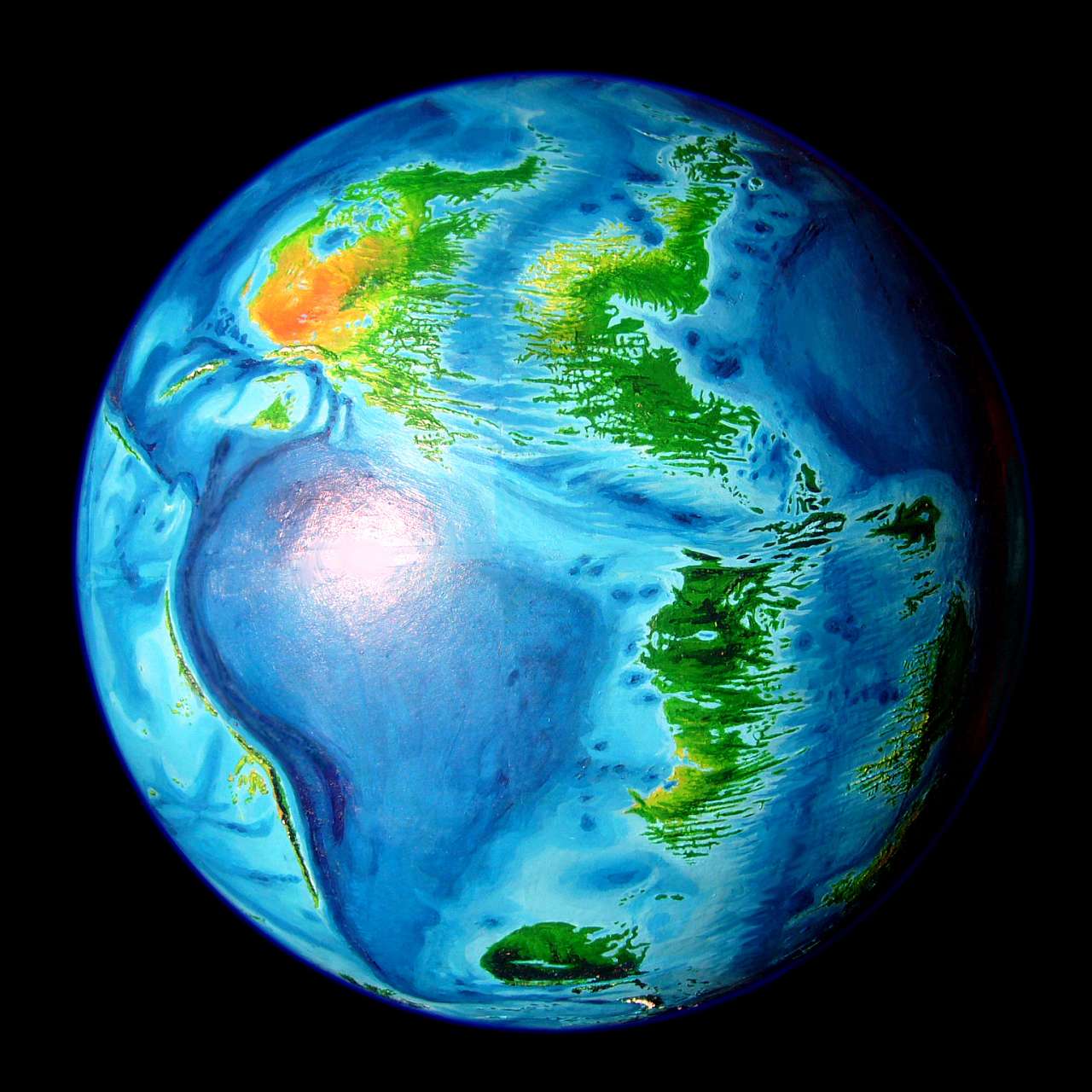
Our Indian Ocean floor is complex, but very little of that complexity breaks the surface. Madagascar, the great arc of reefs from the Seychelles to Réunion, the long line of the Laccadive and Maldive Islands south from India, the chilly islands of the Kerguelen plateau off Antarctica, a few random islets... and you're done. The sea hides the great Y-shaped rift-ranges, the intricate fracture systems branching off the rifts, and the almost Andean mountains called the Ninety East Ridge.
On Abyssia, the Indian Ocean becomes a rise, of course, but not a great continent called India (or Indiana?) That forking rift zone splits the Indian rise into three platforms supporting nine major landmasses. Six are islands or archipelagos about the size of Madagascar--Agulhas, Bouvetia and Natalia in the southwest, equatorial Somalia, and Mascarenia and Crozetia. Three surely qualify as continents: Weddellia in the south, Whartonia in the east (by far the largest--nearly Australian), and its western sidekick, Chagosia, just across the narrow channel of the Ninety East Trough.
Mascarenia and Crozetia are twin islands flanking the narrowest stretch of the Indian Rift, called the Indomed Rift. This diagonal slash (and its attendant fracture zones) dominates the region. Long sounds and capes abound.
Neither island has high mountains; Mascarenia's western hills reach 1.5 km (5000'), but overall few peaks pass 1000 m (3300').
Since both islands are spidery and no larger than Madagascar, most of the climate is maritime. Sea winds can penetrate much further inland than in Australia. They're mostly wooded. Only Mascarenia's midwestern plains feel truly continental--here you find semiarid savanna reminscent of southern Africa. Crozetia's west is Mediterranean (in both latitude and climate); groves and strips of trees, with some brush and meadows in the lowlands, and pine-clad hills. Southern Crozetia's hills get some snow; the rest of the region is subtropical.
Intro - Mascarenia - Melville Sound - Crozetia - Sapmer - Naming - People
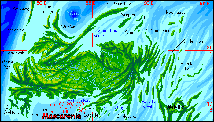
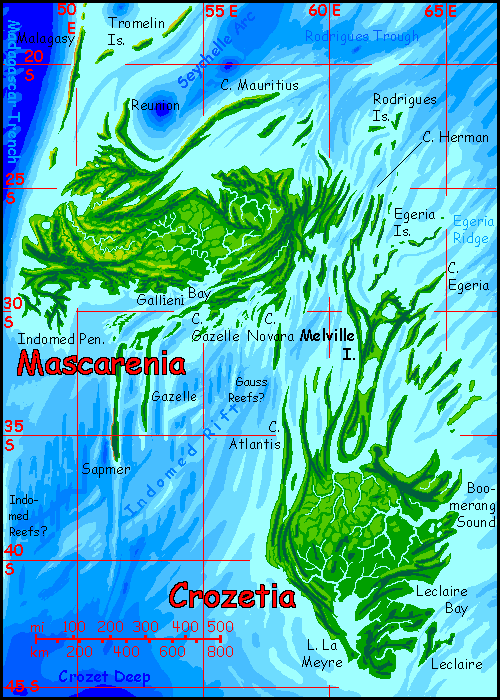
Mascarenia is greener than our Madagascar for a couple of reasons. Madagascar's highest mountains, 2-3 km (7-10,000'), form a wall on its east coast. That shore is dense rainforest, but the lee side of the mountains--most of the island--is in their rainshadow. And the locals, in the last few generations, have cut many of the woods in the highlands and east.
In contrast, Mascarenia's relief is low--the eastern hills are barely 1 km high (3300'); even the western ranges top out at only 1.5 (5000'). They cast local rainshadows--their west faces and sunny valleys to the north and northwest are open, dry grasslands. But overall, Mascarenia's quite green. And its inhabitants have had no reason to cut its groves, not at any unsustainable rate at least. Abyssia as a whole has maritime climate, hence more forest cover; few lands have a wood shortage. Quite the opposite. Now if clearings, meadows and grasslands could be exported, greedy Mascarenians might recklessly export their scant, precious open spaces...
But they won't. They'll value them. Big nomadic herds of centauroid grazers here, and centauroid hunter-gatherers. And huge ostrichy flightless birds, also with small forehands aiding in foraging--and making tool use easy. Are any of them intelligent? Possibly more than one species; since they all have hands, they can imitate any tool-use they see. These species may all push each other into a long spiral of tool-use and brain-growth.
The climate? Mild. All that water is a huge thermal anchor. The weather varies from warm to... warm.
Intro - Mascarenia - Melville Sound - Crozetia - Sapmer - Naming - People
Islands, islands, islands! Long rugged ridges, nappy green in the generous rain. This region between Mascarenia and Crozetia is one of the few places on Abyssia where a rift surfaces. Instead of the ridges meandering through our ocean basins, Abyssia has meandering canyons down the middle of its three great rises: the Atlantic, the Pacific, the Indian. These are mostly of a middling height--and that means these raw seams of spreading crust are mostly a couple of kilometers down, both on Earth and Abyssia.

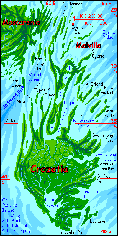
But this stretch of the Indian Rift, called the Indomed Rift, not only narrows way more than is normal, it's shallower. Many of the flanking ridges, formed as the crust accordions under the pressure of spreading, rise above water, forming the Bartleby and Egeria Islands as well as Cape Herman.
In the Indomed region such ridges aren't just uniquely visible, they're peculiar. Worldwide, rifts (spreading zones) have just two common patterns:
Climatically these exposed rift-islands are equally confusing--a patchwork of microclimates ranging from verdant forest to prairie and dry rocky scrub. It all depends on an island's topography, and on how much open water's upwind. Northwestern slopes face the hot afternoon sun, and are downwind to the few rains. Southeast slopes catch the most rain. Low islands don't snag much rain; craggy ones do better. Isles in the south resemble Polynesia more; to the north, they're a bit drier. Overall, they're quite livable and very scenic--splinters of crust new-born from the Indian Rift, after all! Seacliffs and steep ridges punctuated with occasional volcanoes...
Intro - Mascarenia - Melville Sound - Crozetia - Sapmer - Naming - People
Mascarenia was subtropical with an emphasis on the tropical; frost is rare, even in the mountains (such as they are). Crozetia is subtropical with an emphasis on the sub. Frost is more common, even regular in the south--the island gets down to 44° south, after all. If the hills weren't so low we'd see snow. And occasionally you do, on the highest peaks around Lake Lameyre.
Not that they're very high. All Crozetia is under 1 km (3300'); even for Abyssia, it's low. Nor do these hills have more than local climatic effects; they generally don't lie across prevailing winds. No rainshadows here--and no deserts. Northern and central Crozetia have Mediterranean weather--more generous rains in winter, and occasional summer typhoons and thunderstorms, but overall, it's mild. Enough dry sunny weather for meadows, especially on the northwest slopes of hills; enough rain for trees, especially along streams, the cooler southwest slopes of hills, and their cloud-catching crowns.
In the cooler, rainier south, the forests are unbroken; broadleaf on the plains around Lake Lameyre, conifers in the hills.
Intro - Mascarenia - Melville Sound - Crozetia - Sapmer - Naming - People
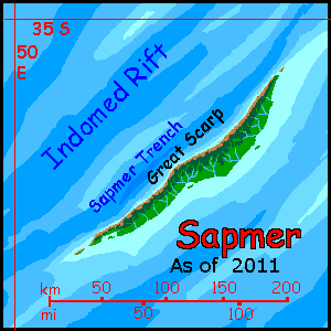
Sapmer is largely guesswork. It's based on soundings that revealed an isolated seamount up to 5700 meters tall (19,000'), hidden in the Indomed Rift. Of course this Sapmer Seamount becomes, on Abyssia, just another deep hole. Of more interest to us (at least to my land-animal readers) is that to be that tall, this mountain had to rise from sea floor as much as 5700 meters deep. None of my older maps showed trenches much over 4 km down--so none of it broke the surface on Abyssia. But the description of the floor around our Sapmer Seamount implies, on Abyssia, a rugged island whose northwest coast rises in cliffs up to 1100 m high (3600'), like Kauai's Na Pali coast.
The exact extent of Sapmer Island is uncertain, but with heights that emphatic I'm assuming it's substantial.
So my rendition is necessarily speculative, based mainly on the tendency of features here in the Indomed to stretch northeast-southwest. But Sapmer could be only 100 km long, or 200 as I've shown it, or a chain of islands several hundred km long, or a lonely, bizarre crag half a mile high like Ball's Pyramid on Earth (Google that for a strange sight--like a Roger Dean fantasy painting come true!)
But the truth could be anything from the more-or-less New Caledonia I've shown, to a Hawaiian chain, to a mad cathedral spire, and until someone springs for the funding to map the Indomed properly, my guess is as good as any. Tour it now before it disappears!
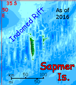
Or, of course, transforms. In 2016 I found a new version of the General Bathymetric Chart of the Oceans (GEBCO) showing chaotic fracture zones making Sapmer a north-south splinter not paralleling Indomed Rift; and, though smaller now, it may have satellites, especially to the northeast. The Sapmer Archipelago!
Still, Sapmer Revised is just as unreliable as the first map--a lot of the detail on the GEBCO map is noise; it's from dips and bobs in satellite orbits due to slight variations in Earth's gravity as the sats flit over the Indian Ocean, and that's assumed to be undersea ridges and valleys tugging at the sat. But it could just as well be gravitational hiccups. That single ship-based sounding makes it clear some land is here, but the details remain blurry.
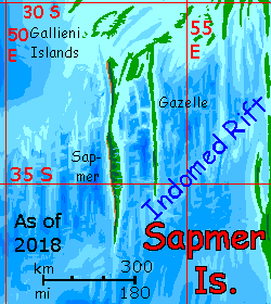
The data's still in flux. To right is Sapmer Re-revised, the 2018 version--in light of improved GEBCO maps showing two much longer islands (our Gallieni and Gazelle Fracture Zones) nearly linked to Mascarenia in the north--not lonely pelagic islands at all.
Today, about all I'm confident of is that Sapmer's island(s) will be long and narrow with spectacular sea-cliffs; no matter whose maps I favor, that tangle of peaks and valleys is all steep topography.
Intro - Mascarenia - Melville Sound - Crozetia - Sapmer - Coastlines & Names - People
We tend to think of the abyss as a featureless muddy plain. The truth is that every new sonar sweep reveals more complexity; it's quite jagged down there.
So these islands' low altitudes don't mean they're gentle. This is young, raw crust full of scarps, ridges and canyons--it's just that many are still underwater. But not all! Melville Sound between the two main islands, especially, is jagged country--an endless procession of cliffy heads, deep sounds, islands and shoals.
Much of the abyss, even today, is poorly mapped; so shorelines on Abyssia aren't always certain. The Indian Ocean has been less studied than, say, the North Atlantic or around Hawaii. Some areas, notably Madagascar and the coasts of Australia, have fine resolution and named features; most areas are so-so. I'm fairly confident of the shorelines of the main islands; the broad patterns of hills and valleys are probably right, but details are guesswork.
The Indomed Rift has bold relief, but it's poorly covered on most maps. None of mine showed Sapmer Seamount, nearly reaching the surface in waters up to 6 km deep (a nearly 20,000' ridge no one noticed) in the heart of the Indomed--hence my Sapmer Island. Are there more such overlooked ridges? I suspect so. I've hinted at these by letting the Indomed's ridges nearby approach the surface, but the maps of this area I have all disagree on details.
It's not just accurate soundings in short supply in this lonely stretch of ocean; names are, too. And my sources sometimes disagree--though not as badly as in the southeast Pacific or southern Atlantic. In such places Abyssian names may be based on a distant Earth feature. On Earth, a seamount or islet often gives its name to a nearby fracture zone--and these zones can stretch 2-3000 kilometers! So on Abyssia, the name may crop up on a peninsula or sound a whole continent away. And many atlases ignore the lesser fracture zones, so names here can look like thousand-mile errors.
Fortunately, such displacement is less extreme around the Indian Rise, because fracture zones here are shorter and curve more than in the Atlantic--an effect of the curved and forked rift itself, I'm sure. Still, names get borrowed from features hundreds of kilometers away--like Lake La Meyre, or Leclaire Island, or Crozetia itself, all from islands and seamounts well to the south. Nothing closer has a name; why name mere bumps on the abyssal floor?
Even the islands in Mauritius Sound are named for much, much smaller islets off Mauritius and Rodrigues Island on Earth.
In short: the names may seem strange but most are based on real ones on Earth. Judgment calls, yes, but the names are not arbitrary, any more than the landforms are.
One exception: the Melville region is especially rich in features and poor in names, so I've borrowed names from his books for features on Melville Island and environs--Ahab, Moby, Queequeg, Pequod, Omoo, Typee, Bartleby...
Intro - Mascarenia - Melville Sound - Crozetia - Sapmer - Naming - Peoples of the Archipelago
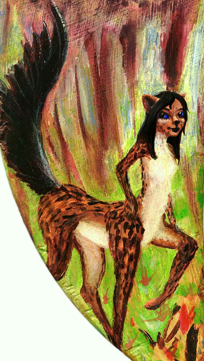
Who'll inhabit Mascarenia and Crozetia? I'm less certain of this region than others. It's far from any of the three continents that evolved centauroid mammalian people, leptaurs, equi, and foxtaurs. But the latter two species face extra deepwater gaps to get here from the Pacific hemisphere; from Atlantis, though it's a long way off, a chain of mini-continents along the Atlantean Rise--Azorea, Guinea, Angolia, Tristania, Bouvetia, Agulhas and Natalia--form a great, sinuous highway encouraging travel and trade. Only the deep moat immediately around the archipelago discourages explorers from this direction. So I suspect the most likely to have arrived here by boat will be Atlantean leptaurs (left).
They'll be relatively recent immigrants, though--only a few centuries, a thousand years at most (on Abyssia, that's recent!). And perhaps not numerous. They like sunny savanna, so northwestern Mascarenia and its attendant islands, especially the west coast of Réunion, will have the largest populations. I don't expect many in eastern Mascarenia, the Melville Archipelago, or Crozetia, except northern inland plains. Warm enough--even Crozetia--but all these coastal lands are too damp for them.
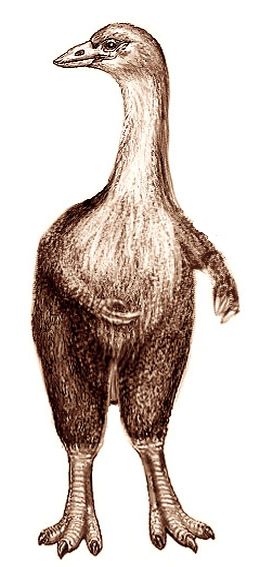
Given Mascarenia's location not far from our Madagascar, and its even greater biological isolation, I'd guess the dominant avian will resemble our extinct Elephant Bird or Aepyornis--the bird whose eggs likely gave rise to the Indian Ocean legends of the Roc. But the Mascarenian or Crozetian Aep (right) won't be extinct! Big, flightless rocs were helpless against the weapons of human invaders, but these Aeps will have brains, hands and tools just as clever as those of leptaur settlers. And they're quite a bit larger. And territorial. That's why (not being fools) the leptaurs will come to trade, not raid.
Both sides gain. Aeps, with their great weight, have lost the light hollow bones of their flying ancestors. They're solid-boned and muscular. No fat either; what little insulation they have is mere feathers. So in water, an Aep just sinks! Understandably, they're unenthusiastic sailors and never tried to sail the long gaps between their islands and the rest of the world. They may not have even realized it was out there. Mascarenia: world enough.
Even today, with routes well mapped and shipping routine, few Aeps have ever traveled overseas. They're glad to get foreign goods, but equally happy to let someone else--of any species--risk long trips over that nasty wet stuff just waiting to devour you.

Abyssia's homepage - map - peoples - regional tours - names
LISTS AND LINKS: More worlds? Planetocopia! - dreams of other worlds - ecology - climate change - evolution - natural disasters - terraforming - sculptures and 3D art -
World Dream Bank homepage - Art gallery - New stuff - Introductory sampler, best dreams, best art - On dreamwork - Books
Indexes: Subject - Author - Date - Names - Places - Art media/styles
Titles: A - B - C - D - E - F - G - H - IJ - KL - M - NO - PQ - R - Sa-Sk - Sl-Sz - T - UV - WXYZ
Email: wdreamb@yahoo.com - Catalog of art, books, CDs - Behind the Curtain: FAQs, bio, site map - Kindred sites