World Dream Bank
home -
add a dream -
newest -
art gallery -
sampler -
dreams by
title,
subject,
author,
date,
places,
names
Abyssia:
Morningtonia
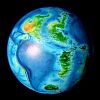
by Chris Wayan, 2010
for Marie Tharp and Bruce Heezen, oceanographic
pioneers of this neglected region on Earth
Abyssia home - down to
map -
building Abyssia -
geology & geography -
critters & cultures -
the clash of names -
more worlds? Planetocopia!
Overview
-
Humboldt Pen. -
Midlands -
Fractures & Bridges -
South -
Valdivia Is. -
Amundsen
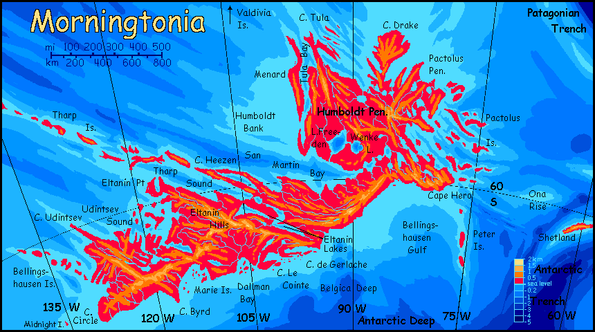
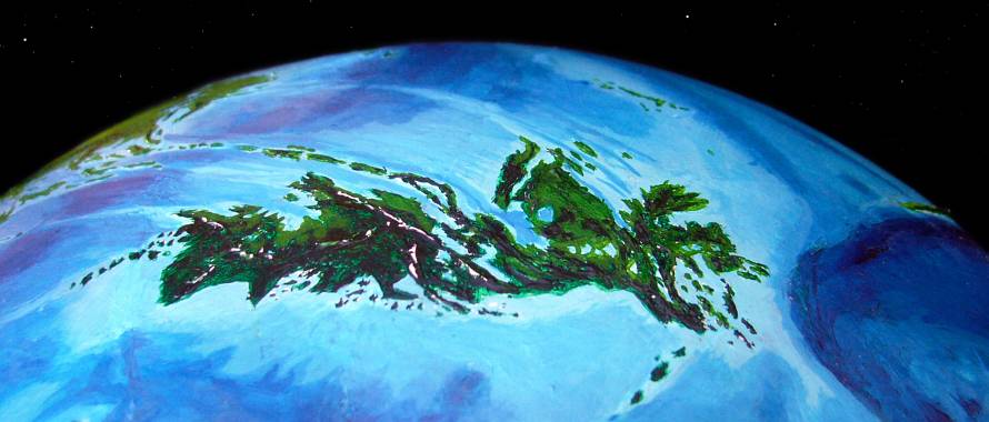
Morningtonia is a small, cool, rainy continent in the South Pacific, rather like its big sister to the east, Weddellia. Morningtonia, though, is less polar, mostly straddling 60° south; only Cape Circle in the far southeast sees a midnight sun in December and a sunless Yule in June. In our world 60 south is the Antarctic Convergence, a ring of the nastiest weather on Earth; but this is Abyssia. Both poles, and especially the southern, are warmer than Earth's, with much gentler weather.
 Why? Abyssia's CO2 levels are no higher than Earth's. The reason's geographic, not atmospheric. Abyssia lacks land at the poles to build up substantial icecaps like our Greenland or Antarctica. The height of our polar ice-domes, not just their latitude, cools their tops to near-Martian temperatures; winds off these icefields spread cold dry air, cooling the climate for thousands of km around them. Without these dubious gifts, the Abyssian poles are much milder. Though winter sea-ice is extensive, it's less than a meter thick and melts entirely each summer.
Without the Antarctic ice dome to drive those fierce winds, the region is cool and rainy but not harsh. The British Isles? Southern Scandinavia? Snow at sea level most winters, except in the warmer north; but despite the latitude, this isn't Siberia.
The rainy summers nourish a dense forest broken only by thousands of bogs and lakes dotting the lowlands, and by the highest peaks. These are under 2 km high (6600') and mostly half that or less; though at 50-60° south, you don't need to be high to be alpine.
Overview -
Humboldt Pen.
-
Midlands -
Fractures & Bridges -
South -
Valdivia Is. -
Amundsen
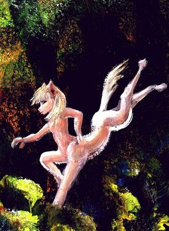
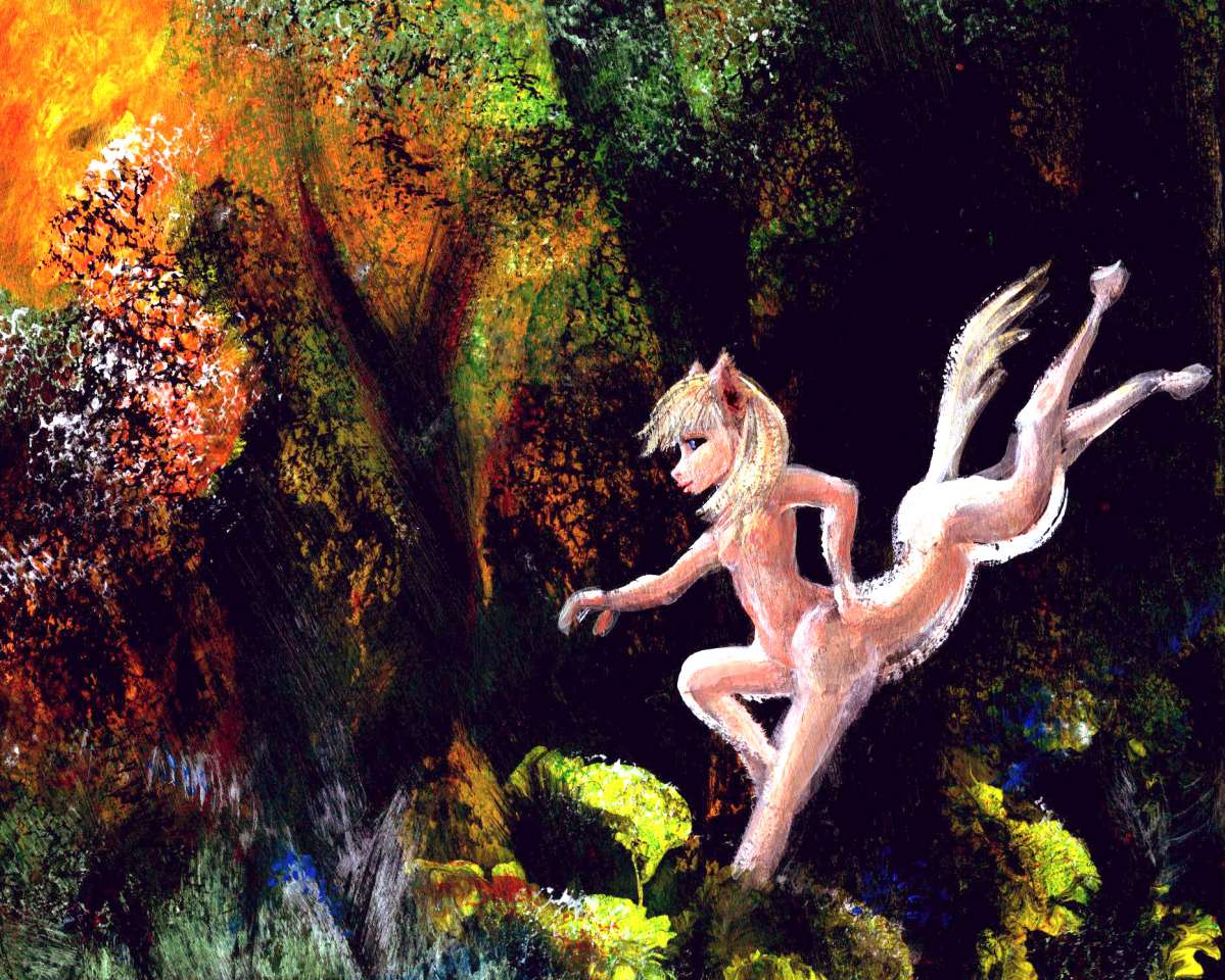
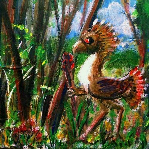
Equa leaping through Humboldt woods
|
The northeastern Humboldt Peninsula is the warmest and most fertile part of Morningtonia; here evergreens tower, reaching 100 meters in sheltered valleys. Capes Pactolus, Drake and Tula, and the north end of the Isle of Menard, are warm enough so many broadleaf trees enter the mix. This end of Morningtonia's not just favored by latitude: the hills are lower, too. Antipodal prehistoric England! But more indented--indeed, convoluted. More like a mild Scotland with its isles. Coastal shipping will be easier than land travel here.
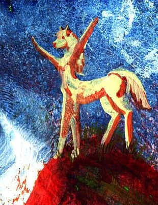
Humboldt is the only mainland part of Morningtonia heavily settled by equi, those gracile, centaurlike mammals native to Agassiz, the great continent to the west. Out on those plains, equi are lanky, even delicate, built for heat dispersal not retention. Not Humboldtians! The cold has, over generations, selected for big, muscular, shaggy and athletic. In the Abyssian Games, fully half the winners of the Mammalian Long Jump are Morningtonians. Here's a delicate maiden (by local standards) bounding through the Humboldt woods in the usual boisterous Morningtonian way...
Pleasant country, pleasant people. If you can tolerate all that sub-arctic joviality.
In contrast, next to no one lives on the east coast, south of Cape Hero. It's bare to polar blizzards; stunted taiga at most where the coastal plain broadens, as in Dallman Basin. The ridges grow rugged, bare and windy; even in high summer, just grass and stone.
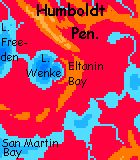
Two or three million years ago, Humboldt got hit. A space rock at least a kilometer across (maybe two or three!) struck near the east shore of Lake Wenke. Today it's a horseshoe bay over 25 km across, with twin craterwall headlands. The lake's just too deep for the complete ring to be visible. This impact was much smaller than Chicxulub (a TEN-kilometer rock, certainly 100 times the mass and likely much more), but the blast burnt all the woods in Humboldt and the midlands, followed by tsunamis drowning all the lowlands for thousands of kilometers, and spoiling the world's climate for at least a decade.
Any biological traces today? Of course not. Ancient history. Morningtonia's as rich and diverse as any land at this latitude.
I mention the impact mainly because I had to throw a rock at Abyssia; Abyssia is Earth. We got hit at that time and place; it's called the Eltanin impact. But as Ice Ages came and went, the sea rose and fell, erasing most evidence; only meteoric nickel-iron found on the seafloor proves what struck us. Biospheres heal such wounds rather quickly.
Book-critique time! Mary Robinette Kowal's science fiction novel Calculating Stars (and sequels) describes a near-identical impact, though she aims it near Washington DC, to maximize human drama. I'll grant that it's a gripping picture of a disaster... but the climatology is laughably wrong. This modest oceanic impact causes runaway greenhousing--vapor heats ocean creates more vapor--supposedly ending with boiling oceans! Because a zillion previous rocks NEVER hit the sea ONCE? Please. And in deep time Earth's NEVER been hotter or steamier, can't take the heat? Please, please. And those new clouds wouldn't cool us off again? Please, please, please. We're on the verge of catastrophe--one rock'll kill all life on Earth! Kowal thanks an astronomer (who I mercifully won't name) for "explaining" how our climate's so unstable it can't handle one punch. The thrill of catastrophism makes even smart people throw out common sense.
Anyway, you won't find a single sign of this disaster on Morningtonia, unless you visit Lake Wenke specifically to see Eltanin Bay--just Crater Bay to the locals. It is quite scenic, and the local museum has so many samples of meteoric iron dredged from the lake, you can buy one. Your own souvenir of the End of the World.
Overview -
Humboldt -
The Midlands
-
Land-Bridges -
South -
Valdivia -
Amundsen
The midlands--the long valleys around San Martin Bay, Tharp and Udintsev Sounds--are dark evergreen forest below alpine ridges. Sweden, southern Norway, the Alaskan Panhandle?
Of course the Abyssians may clear these Great South Woods to farm (by no means certain, as many species may be arboreal or even fliers--they'd be more likely to practice silviculture, harvesting from the treetops). But if they do farm in the human sense, then Morningtonia could look even more British: fields, groves, meadows for grazing.
But maybe not. All Morningtonia's cool but livable--for Terrans. But the fauna of Earth, with its broad subpolar lands and a history of ice ages, has a long familiarity with cold. In contrast, most Abyssian land, and life, is subtropical or tropical; only Morningtonia and its sister continent, Weddellia, have snowy winters. Many Abyssian lines may not have evolved to tolerate freezes; here, what we'd call "temperate" zones are a harsh, exotic, trivial niche.
 So the Midlands may be a frontier simply because Abyssians find it cold, dreary and, well, stingy. After all, even humans, long adapted to wearing stolen furs and playing with fire, still find little to eat in thin evergreen forests; hunting, herding, berrying in sunny patches, or clearing the land laboriously for summer gardens aren't easy even for us, and may be even harder for Abyssians. Until we know what they evolved from, we can't be sure. Perhaps they have natural coats that limit their use of clothing, limiting them to warmer climates; perhaps they aren't carnivorous and expect to cultivate fruit trees and nest in them; perhaps they require meadows to graze in, or bogs, or are fliers too lightly built to easily clear natural groundcover to farm.
In any case, this strange and rare (for Abyssia) ecology will likely be sparsely populated; life here might be easy for us, but not necessarily for the natives.
Except seasonally. It's possible some Abyssians will fly, though not as likely as on some other worlds postulated here in Planetocopia. Winged Abyssians may well be migratory; Morningtonia might be their summer garden and playground, even a nesting ground. Fast-growing gardens in those long summer days (though most of Morningtonia's not quite far enough south to see the midnight sun; but summer nights are short and indigo, with hardly a star--too bright). But this beloved continent-size summercamp gets left to the dark and silence when days grow short in April. By the first snows of June, the woods echo empty.
Overview -
Humboldt Pen. -
Midlands -
Fractures & Bridges
-
South -
Valdivia Is. -
Amundsen
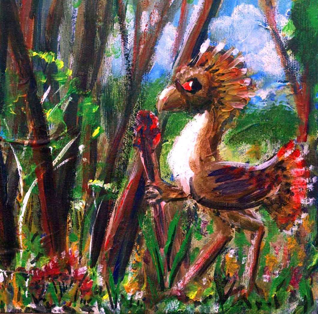
Moa with staff of master trader, San Martin Bay
|
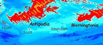
Morningtonia's shaped by the nearby East Pacific Rift and its attendant fracture zones, though it's not as blatant as in the bizarre washboard-continents of Atlantis and Azorea. Morningtonia's relief is subtle. Subtle enough, I'm afraid, that the coastline shown is one of the most uncertain on Abyssia. And low relief's not the only reason I mistrust it: the region, our southeast Pacific, is Earth's true Empty Quarter--the biggest stretch of sea without a single speck of land. As a result, it's the worst-charted region on Earth, worse than Antarctica or the Arctic Sea floor. Many world maps just slap their legends and scales on top of it and show you nothing. And what has been sounded is mostly the rift zone and the few discovered seamounts and reefs, not the abysses. I've found more contradictions between atlases in this region than any other. So while Morningtonia certainly is this size and general shape, the low relief and conflicting data make its exact coastline less reliable than for other continents.
One exception: the Tharp-Heezen-Eltanin fracture complex is a big, bold feature that nearly bisects the continent like a cinch around its waist. Such fractures give as well as take! Tharp Sound and the long Eltanin Lakes nearly cut Morningtonia in two, but Cape Heezen and the rugged green Tharp Islands, thrust up by the same fracture, link Morningtonia to the huge continent of Agassiz to the northwest, and to Pacifica beyond. Morningtonia will not be empty; if native life doesn't evolve intelligence, someone will have sailed in from Pacifica; and that settlement will be ancient. Australia, not New Zealand.
The most likely candidates, then, are both Agassizian:
- A large flightless bird we'll call a Moa, though it doesn't much resemble one except in sheer size and robust build. Tall as a human even without that feathered crest, omnivorous, with strong hands (all Abyssian vertebrates are six-limbed; for birds that means wings, feet, and forehands; usually small, but moa hands are quite stout). These moas are large and shaggy-feathered enough to stay warm and comfortable down to near-freezing, though not below. To other Abyssian species, who mostly evolved to shed heat not conserve it, moas seem positively polar, though many Terran mammals do well at much colder temperatures. But then we have vast temperate and subpolar regions, and repeated Ice Ages; Abyssia has neither. Moas have gotten more cold-tolerant over the millennia since settlement--genetic drift--but they started out predisposed that way: they came along the Tharp Islands from southeastern Agassiz, a cool and rainy region.
- A centauroid mammal, gracile, deer-sized, who we'll call the Equi. Many tribes with varying faces, builds and colors; all omnivorous tending to vegetarian, preferring prairie to woods and warm to cold. Hence eqs live mostly on the Humboldt Peninsula and the Valdivia Islands in northern Morningonia; in the middle and southlands, moas outnumber them ten to one.
Morningtonia's quite isolated to the north, south and east, where the fractures fade. It's over 600 km (nearly 400 mi) from the east coast to Shetland, first of the Scotia Archipelago, leading to Weddellia and the Atlantis continental cluster. The Ona, Hero and Sars Banks, natural stepping-stones to Scotia, are excellent fishing banks but unfortunately never quite break the surface. Morningtonia's often referred to in other tours as part of the Antarctic Ring, a circle of smallish continents around the south pole at cool-temperate latitudes; but it's a snipped, broken ring. East of Morningtonia's the biggest gap.
If the Sars Banks, nicely midway between the Scotia Isles and Cape Hero on Morningtonia, were just a little higher, making an easy link, it's likely other species would join the mix in much greater numbers--leptaurs, a catlike centauroid, and bronts, an even larger (and more aggressive) flightless bird, in particular. But as it is, it's a long chilly sea-passage and only in recent centuries has shipping become regular to the east.
Overview -
Humboldt Pen. -
Midlands -
Fractures & Bridges -
South
-
Valdivia Is. -
Amundsen
I have little to say yet about southern Morningtonia. Even though humans would find its endless SIberian evergreen woods quite habitable--cool-temperate or subarctic, not arctic--it may be virtually empty, except in summer. Perhaps as Abyssia develops and the avian species come into focus, we'll find a feathered, flightless giant big enough or shaggy enough to stay comfortably warm in these dark woods--maybe someone like New Zealand's extinct Moa. Well, moas with brains, cabins and hatchets--it takes firewood to last through the long, gray, tedious winters down there. I couldn't take it.
Yet it really isn't polar. Cape Circle (as its name suggests) is the only spot to face a couple of sunless winter weeks. Despite its name, Midnight Island's just north of the Circle and never quite sees the midnight sun or darkness at noon.
Overview -
Humboldt Pen. -
Midlands -
Fractures & Bridges -
South -
Valdivia Is.
-
Amundsen
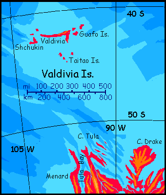
And now for something completely different! 1000 kilometers north of the Humboldt Peninsula are the lonely but pleasantly mild and fertile Valdivia Islands. Truly lonely: it's 1500 more km from Valdivia to anywhere else--west to the Foundation Islands off Agassiz, north to Sala-y-Gomez (another fertile but lonely pseudo-Hawaii), or east to Chilea in the Andean Chain (10,000 km of long mountainous slivers of land--the equivalent of our Andes Trench).
I've included Valdivia here not because it's tightly linked to Morningtonia geologically; I'm not even confident it's linked culturally, settled by brave (or clueless) mariners from Morningtonia. Just as likely to be strays from Chilea, or Sala-y-Gomez--it's a busy port. Still, the Valdivias are too small for their own page, and Morningtonia's the nearest land, so here we are.
Valdivia proper, by far the largest in its archipelago, is bigger than the whole Hawaiian chain--slender but a good 320 km long (200 mi). At 42° south its climate is mild-temperate or cool-subtropical: think Bordeaux or Portland. Or the Azores, if you like. Its shores are sheltered by a halo of lesser islands; the shallow sea around Valdivia's as bountiful as the land. Quite a pleasant little world of its own--just not an easy one to reach.
Eq pilot signals ships from Northport Jetty
|
My best guess is it'll be a quieter, more easy-going and rural version of Sala-y-Gomez--no big cities, but a diverse rural population of eccentrics who like solitude and came here to get it. The most common species will probably be equi or moas or both.
I could be wrong, though. Much of the world's trade should pass between the biggest landmasses in the world--Pacifica and Agassiz in this western hemisphere, and the long chain of Atlantean lands in the eastern. But the long Andean Islands--Andea and Chilea--lie across and block the best trade routes between these two world hubs. I've projected great ports will arise at the strait between Peruvia and Chilea, the Nazca Gap. But the Gap has coral reefs bigger than our Great Barrier Reef just west of it, requiring expert local pilots--and that means fees and tolls! Like freighters avoiding the Panama or Suez Canal by sailing round the Horn or Cape of Good Hope, some Abyssian mariners, especially those heading to and from the lands of South Atlantis, may 'round the horn' of Chilea, called Cape Chanco. It's longer than the Nazca route, but not nearly as long or risky as rounding our world's Horn; Chanco's just 35° south, with generally good weather and an uncomplicated approach, unlike the reefs around Nazca.
So the route round the Horn may be busy! And Valdivia, isolated though it is, is right on the shipping route from Pacifica and/or Agassiz to Port Chanco. If the route's used much, Valdivia may have quite a busy port of their own--restocking, entertaining, shipbuilding (or at least repairing). It'll be on the sunny north shore of the main island if it's there at all.
I think it will. Isolated isn't always lonely; consider Hawaii.
Overview -
Humboldt Pen. -
Midlands -
South -
Fractures & Bridges -
Valdivia Is. -
Amundsen
South of Morningtonia? Oh, no one (sane) goes south. A few hundred km out, the dreary Peter Islands dot the Bellingshausen Sea. Treeless on the windward shore and stunted spruce taiga on the lee, the Peters are snowed in much of the year, boggy and buggy in the brief summer.
And beyond them, the Antarctic Abyss stretches to the pole--a white plain of death in winter and spring, a groaning, ship-killing mass of bobbing pack ice in summer, whose blue veins broaden and merge briefly in fall to reveal a dark sea 5 km deep and larger than our Arctic Ocean. Not a speck of land.
Oops. I lied. Not intentionally. There's one speck of land: Amundsen Island. I didn't know about it till recently, when I found a single sounding deeper than 4900 meters in a reliable atlas. So...
The southernmost island in the world, Amundsen lies about 750 km (450 mi) southwest of Cape Circle, already the southwestern corner of Morningtonia and (as its name testifies) right on the Antarctic Circle. Amundsen is worse--a full 71° south--a windy, cold little island with grassy, rocky fells up to a kilometer high, where ice patches hang on through summer (especially on the southern shoulders) but never acquire the muscle to mantle the coasts. Stone, grass, moss. The air rings with the shrieks of a million birds, who nest during the wan, short summer. Stunted trees grow only in sheltered northern valleys.
Harsh though it is, consider this: Amundsen is just as far south as our Antarctic coast. Yet it bears more life than our Cape Horn, at 56° south, or even Kerguelen, at just 48°. Do you think trees are unlikely on Amundsen, just 19° from the pole? Our own Siberian treeline has already crept closer, within 18° in a few spots; and we're still recovering from the last Ice Age, a little climate problem Abyssia's never faced. Yes, the wind limits trees on Amundsen to sheltered hollows and slopes. The wind, not the cold.
Drowning Antarctica makes all the difference! Icecaps just ruin the whole neighborhood. Nice that we're getting rid of the nasty things.
 TOURS: this route snakes around Abyssia's major lands -
Lena Is. (brr!) -
Greek Is. -
Atlantis -
Azorea -
Cayman and Albatrosia -
Andean Is. -
Scotia Is. -
Morningtonia -
Agassiz -
South Pacifica -
East Pacifica -
Hawaiian Sea -
Pacifica Desert -
Filipinia -
Banda Is. -
Vityaz Archipelago -
Tasman Is. -
The Bight -
Whartonia -
Chagosia -
Somalia -
Mascarenia and Crozetia -
Weddellia -
Argentia -
Pernambuco -
Angolia -
Tristania -
Agulhas group
TOURS: this route snakes around Abyssia's major lands -
Lena Is. (brr!) -
Greek Is. -
Atlantis -
Azorea -
Cayman and Albatrosia -
Andean Is. -
Scotia Is. -
Morningtonia -
Agassiz -
South Pacifica -
East Pacifica -
Hawaiian Sea -
Pacifica Desert -
Filipinia -
Banda Is. -
Vityaz Archipelago -
Tasman Is. -
The Bight -
Whartonia -
Chagosia -
Somalia -
Mascarenia and Crozetia -
Weddellia -
Argentia -
Pernambuco -
Angolia -
Tristania -
Agulhas group
Abyssia's homepage - map - peoples - regional tours - names
LISTS AND LINKS: More worlds? Planetocopia! - dreams of other worlds - ecology - climate change - evolution - natural disasters - terraforming - sculptures and 3D art -
World Dream Bank homepage - Art gallery - New stuff - Introductory sampler, best dreams, best art - On dreamwork - Books
Indexes: Subject - Author - Date - Names - Places - Art media/styles
Titles: A - B - C - D - E - F - G - H - IJ - KL - M - NO - PQ - R - Sa-Sk - Sl-Sz - T - UV - WXYZ
Email: wdreamb@yahoo.com - Catalog of art, books, CDs - Behind the Curtain: FAQs, bio, site map - Kindred sites