World Dream Bank
home -
add a dream -
newest -
art gallery -
sampler -
dreams by
title,
subject,
author,
date,
places,
names
Abyssia:
the Tasman Islands
by Chris Wayan, 2010
for all the lost Tasmanians--human, thylacine, and devil
Abyssia home - down to
map -
building Abyssia -
geology & geography -
critters & cultures -
the clash of names -
more worlds? Planetocopia!
OVERVIEW
-
North -
South -
Settlers & the Tasman Gap -
Natives?
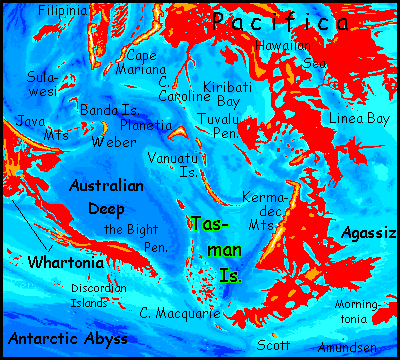
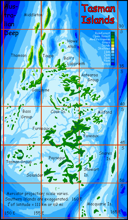
The Tasman Islands are a complex archipelago in the Australian Ocean on the back of the Tasman Rise, a great leaf-shaped continental platform of about 2 million square km (800,000 sq mi) supporting coral reefs in the north and kelp forests in the cooler south. The Tasman Rise isn't far from our Great Barrier Reef, and it's similar--but triple-sized. All it lacks is a mainland!
Instead, a labyrinth of low, narrow but long islands arise from this platform. Their total number and area are hard to determine (and change with the tides) but collectively they're perhaps comparable to our New Zealand's North Island; certainly larger than Tasmania. The largest, Foveaux, in the southeast, may be the size of Taiwan, but again it's hard to say; Foveaux, like all its sisters, is as branched and twisting as the kelp-fronds in its coves.
Intro -
North: Middleton Is.
-
South -
Settlers & the Tasman Gap -
Natives?
The "stem" of the Tasmanian leaf, in the north, from Middleton to Gascoyne, is made up of long north-south ridges (and associated trenches, some miles deep). These parallel the edge of the Australian Abyss to the west and may be a minor subduction/upthrust zone. The ridges, though generally no higher than 500 m (1640') and always under a kilometer (3280'), sprawl across the trade winds and force air up, generating clouds and some rain on the east shores, while blocking rain on the west.
This low, broken wall is downwind of the high Kermadec Mountains on the continent of Agassiz--the Abyssian inversion of our Tonga and Kermadec Trenches. This range snags storms and casts a rainshadow well to the west, though the Middleton chain is far out, at the edge of the penumbra. Still, just as the Galapagos rises 1000 km west of the Andes but still suffers unreliable rains in their shadow, the Middleton chain, twice as far out, suffers--somewhat.
The result: dense forests within a few miles of open savanna (though no true deserts). The Middletons may have less biomass overall than the southern Tasmans, but they're more diverse.
With both coral reefs and deep waters close inshore, fishing will be excellent, too.
All in all, the northern Tasmans are unspectacular to visit, but pleasant places to live, if you have the good sense to live near a creek or have a deep well, plant shade and fruit trees around your house (citrus does well) and grow a garden.
Intro -
North -
South: Undae
-
Settlers & the Tasman Gap -
Natives?
The southern Tasmans, bumps and veins on the broad face of the 'leaf', are all low--at most, 500 m (1640'). Instead of neat north-south ridges, the leaf-face is all aimlessly meandering ridges and sounds; the scientific name is undae. Examples of such terrain are well known on Venus, but they're rare on Earth--on land, that is! But our benthic abysses are richer in undae, and some are deep enough to get exposed here on Abyssia. The Tasmans are the most extreme example. Islands like drunk octopi! (Sorry. Islands resembling drunk octopi. I don't claim islands like drunk octopi. Nobody likes drunk octopi. Those sloppy sticky wet kisses, the circular hickeys...)
I'd describe the southern Tasmans as fractal, and not in a metaphoric or slang way; it's literal. You see the same tangled, writhing shapes on every scale. Compare the huge island of Foveaux to little Milford to its northeast. Eerily similar, just quarter-scale; parent squid-island, baby squid-island.
Sorry. In Tasmania, it's hard to avoid tentacularity. Tentaclism? No, too much like cataclysm, and these sprawling messes have too many legs.
The topography here, though tangled, is just too low to block trade winds or affect clouds, so the southern Tasmans don't vary much in rainfall. They're south of the belt where this matters much; winter storms just sweep over their low hills. Enough rain for all! More than enough. Too much. Drip, drip, drip. Even sea-stacks are green, and the smallest islets have springs. Forests are mossy, misty, dense and dark. Winter's a damp gray affair.
For here in the south, winter snow often falls--not a lot, and not every year, but most. The few of you who really noticed the latitude of the southern Tasmans are now probably muttering skeptically--not at the snow, but at its rarity. On Earth, this is the latitude of grim chilly wind-blasted places like Tierra del Fuego and Kerguelen, where blizzards are common; but Abyssia isn't Earth! Without Antarctica or even a Greenland, the climate here's more like our southern England or Ireland. Cool, wet, but mild.
Still, most people will live on north-facing shores; they're noticeably warmer. And most harbors will be along north coasts, sheltered from polar winds--ferries shuttle and fishing boats rove even in winter.
On the south coast, the winter sea just gets too rough. Shipping halts, and even local fishing boats get hauled out on the shingle. Heading out into that swell and churn wouldn't be flat suicide, but fisher's roulette. One day you'd slip and lose.
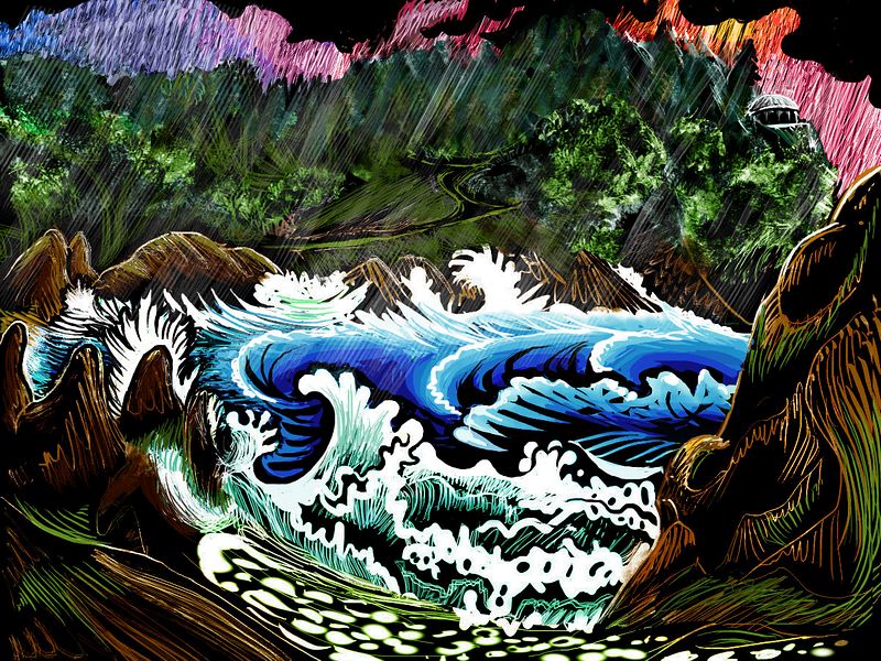
Storm, south Puysegur, Tasman Is. Wayan (2017), after Tom Killion's woodcut 'Yankee Point' (1979)
Orchards and tree crops should do well here--assuming the natives are of a species able to climb trees or fly to the tops to harvest them, of course. Kelp forests offshore will offer very different fishing from the northern coral reefs; but equally rich and varied.
Navigation through the labyrinthine southern reefs, even in good weather, will be difficult, requiring local pilots. Whoever these islanders (or reefdwellers; we can't assume these people are land-animals!) are, we can be sure they're politically and culturally independent; no outsider could thread that maze of channels! Mainlanders from Agassiz and Pacifica may well call the southern Tasmans the Unreachable Isles. As the wistful Agassizian sea-chanty goes:
Un dae I'll land upon that shore,
Eatin' lobster evermore.
Undae...
Intro -
North -
South -
Settlers & the Tasman Gap
-
Natives?
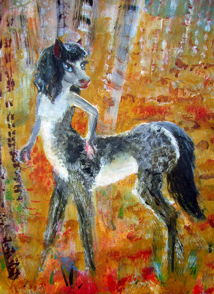
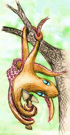
How isolated are the Tasmans? From the continent of Agassiz to the east, it's quite possible for fliers and primitive sailors to island-hop to the Tasmans without deep-sea navigation. From Cape Emerald through the Macquarie Islands you're never out of sight of land. From there or from Snares Island to the north, It's a longer gap, 100 km or more, to the Stewart Islands, the southeastern edge of the Tasmans. So the larger Tasmans will have been settled, if at all, by the dominant species of southern Agassiz: the centaurlike equi and the tall flightless moas.

Antipodian/Tasmanian subspecies of Eq, gray & longfaced.
|
|
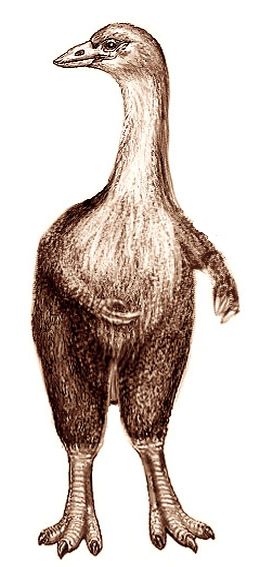
A Moa, native to Agassiz.
|
But in no other direction is there an easy route. To the west, it's a good 600 km (nearly 400 mi) to the tip of Whartonia. It's deep and featureless: the Tasman Trough, up to 7 km deep (23,000'). That deep water gives no hint of the land beyond. The Trough will be a biological barrier like Wallace's Line in our Indonesia--a moat between very different biological worlds: the Greater Pacifica and the Indian/Atlantean hemisphere. It's not a mere artifact of my reversal-game; in our world, it's the boundary between our Indian and Pacific Oceans. And it will not be easily crossed. Abyssian Tasmania, like its Terran namesake, will be isolated.
Intro -
North -
South -
Settlers & the Tasman Gap -
Natives?
Does Tasmania have any true native people--who evolved here? Well, possibly.
I mustn't indulge in hydrophobic monkey bias! These narrow islands aren't a huge land base for intelligence to evolve in, but the Tasmanian reefs are ten times bigger--richer and wider than our Great Barrier Reefs. I think there's real potential among Abyssia's equivalents of marine mammals and octopi or nautiloids. Consider all the creatures, even on poor impoverished Earth, that creep out of the sea to play on the beaches, give birth or lay eggs, climb trees and pick fruit... Unlikely though it sounds to us, given enough time and chances, some Abyssian will crawl out onto land often enough to play with fire! Enough chimps and typewriters, and you get Hamlet. Well, in this case The Tempest.
But are the Andamanese naïve Mirandas, trickster Ariels, or angry Calibans? Depends how stranded mariners and Agassizian settlers have treated them over the centuries. Terran history's discouraging... but then Terran history's always discouraging. If tree-squid read that stuff they'd never crawl out.
But must our tidepool Tasmanians crawl out at all? How far can a society advance in the sea? Remember, they're not alone. Abyssia's a world where they don't necessarily have to melt their own glass, smelt their own metal, fire their own pottery...
After all, isn't that how nearly everyone in our world acquired technology? Did you build your own phone? Intelligent people trade their unique skills for others' unique skills. And on Abyssia, the people are much more physically (and, probably, mentally) diverse than our monotonous mob. They'll swap like crazy.
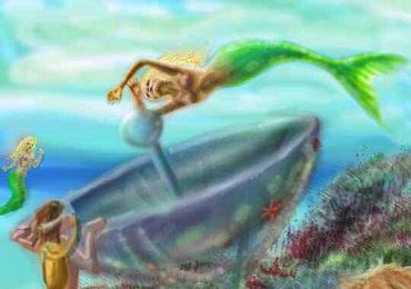 So trade with other intelligent species better adapted to land can get our tidepool natives glass, metal and ceramics in trade for their expertise in harvesting the biological treasures of the reefs--foods and extracts, medicines, inks and pigments, resins and glues, precious corals...
With trade-metal and trade-glass comes interesting possibilities. Here's an experimental solar oven capable of boiling water at the focal point, built by the merfolk of the Autearoa Group, on a sunny two-meter bank. Steam without fire.
Okay, just kidding.
Or am I? Once, I dreamed of that. Ariel the Little Mermaid's descendants, building a solar steam engine, going steampunk--without a lump of coal (or Satanic Mill) in sight.
My point? Once you know metal, pottery and glass are possible--and on Abyssia, someone will have the physical ability to handle fire--you'll devise work-arounds to achieve similar benefits even if there's no trade at all! Resins instead of glass and ceramic; solar cookery instead of fire.
As this sociological insight is quaintly phrased by the primitive monkey-folk of Earth:
How you gonna keep 'em down on the farm
After they've seen Pareeeee?
 TOURS: this route snakes around Abyssia's major lands -
Lena Is. (brr!) -
Greek Is. -
Atlantis -
Azorea -
Cayman and Albatrosia -
Andean Is. -
Scotia Is. -
Morningtonia -
Agassiz -
South Pacifica -
East Pacifica -
Hawaiian Sea -
Pacifica Desert -
Filipinia -
Banda Is. -
Vityaz Archipelago -
Tasman Is. -
The Bight -
Whartonia -
Chagosia -
Somalia -
Mascarenia and Crozetia -
Weddellia -
Argentia -
Pernambuco -
Angolia -
Tristania -
Agulhas group
TOURS: this route snakes around Abyssia's major lands -
Lena Is. (brr!) -
Greek Is. -
Atlantis -
Azorea -
Cayman and Albatrosia -
Andean Is. -
Scotia Is. -
Morningtonia -
Agassiz -
South Pacifica -
East Pacifica -
Hawaiian Sea -
Pacifica Desert -
Filipinia -
Banda Is. -
Vityaz Archipelago -
Tasman Is. -
The Bight -
Whartonia -
Chagosia -
Somalia -
Mascarenia and Crozetia -
Weddellia -
Argentia -
Pernambuco -
Angolia -
Tristania -
Agulhas group
Abyssia's homepage - map - peoples - regional tours - names
LISTS AND LINKS: More worlds? Planetocopia! - dreams of other worlds - ecology - climate change - evolution - natural disasters - terraforming - sculptures and 3D art -
World Dream Bank homepage - Art gallery - New stuff - Introductory sampler, best dreams, best art - On dreamwork - Books
Indexes: Subject - Author - Date - Names - Places - Art media/styles
Titles: A - B - C - D - E - F - G - H - IJ - KL - M - NO - PQ - R - Sa-Sk - Sl-Sz - T - UV - WXYZ
Email: wdreamb@yahoo.com - Catalog of art, books, CDs - Behind the Curtain: FAQs, bio, site map - Kindred sites