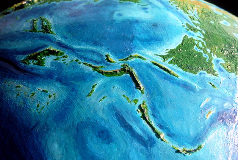
Abyssia: Vityaz Archipelago

by Chris Wayan, 2010
for John Frum
Abyssia home - down to map - building Abyssia - geology & geography - critters & cultures - the clash of names - more worlds? Planetocopia!
Abyssia: Vityaz Archipelago
by Chris Wayan, 2010
for John Frum
Abyssia home - down to map - building Abyssia - geology & geography - critters & cultures - the clash of names - more worlds? Planetocopia!
Introduction - Mtns & Deserts - Peoples - Carolinia - Meteora - Guadalcanal Is. - Vityaz Is. - Solomon - Vanuatu - Outliers
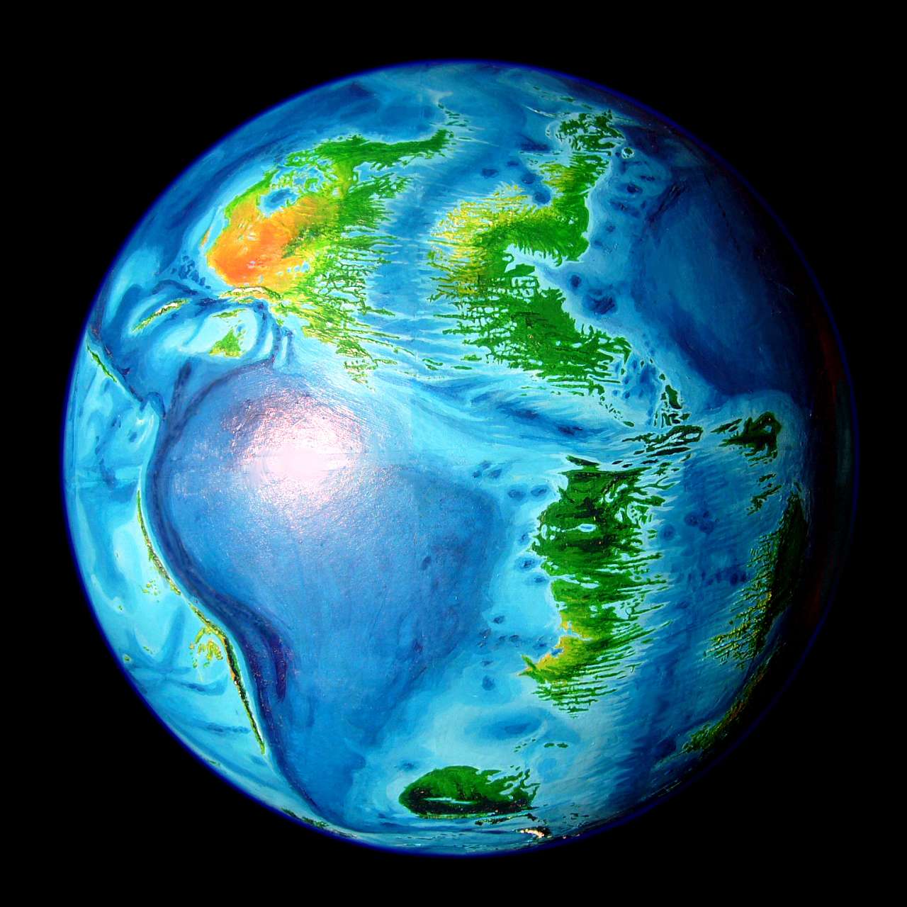
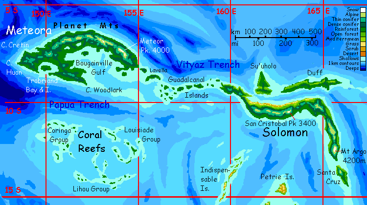
This page, now just a general survey, will eventually be a detailed tour of the complex, scattered Vityaz Archipelago, about the size of Japan, that rises southwest of Pacifica, almost spanning the northern half of the Australian Ocean. The Vityaz Archipelago is the upside-down Abyssian equivalent of our Vityaz and Vanuatu/New Hebrides Trenches. In turn, Earth's island arcs here become, on Abyssia, deep trenches, just displaced a hundred miles or so. Range-and-trench just becomes trench-and-range. It's remarkably like our Melanesia. The region nicely illustrates just how symmetrical up and down can be where tectonic plates meet and overlap!
Intro - Mountains & Deserts - Peoples - Carolinia - Meteora - Guadalcanal Is. - Vityaz Is. - Solomon - Vanuatu - Outliers

Deserts are rare on Abyssia--western Pacifica is a spectacular, but lonely, exception. Most of the sparse land elsewhere is maritime, and most mountains are too low to cast significant rainshadows. Carolinia fits the pattern; it's equatorial, and gets rain year-round. But the Vityaz islands further south have a definite monsoon, with heavy summer rains and dry, mild winters.
Some of these islands have spines so high they block most of the storms sweeping in from the east and south even during the monsoon. None are far enough from the equator for real desert--but distinct rainshadows do get cast to the north and west.
The north shore of Solomon, for example, in the rainshadow of the Cristóbal Mts (3400 m; 11,200'), is rocky, with cactus, dry brush, and twisted little trees that bloom madly in a good year and turn brown in a bad. Yet a few miles up into the hills, you'll find cloudforest; higher still, fernfields and alps, for these peaks (like Hawaii's) face winter freezes and occasional snow; and on their southern slopes you'll find rainforest, humid and fragrant.
To some extent this pattern's true of Meteora and Vityaz, too; lush south slopes, mountains piercing the clouds, drier north shores.
Surprisingly, the Vanuatu Islands, further out of the equatorial belt, are actually greener. Why? These long narrow islands are oriented so storms don't slam into their mountain-spines but blow in along the ridges, watering both sides about equally; plenty for healthy forests.
Intro - Mtns & Deserts - Peoples - Carolinia - Meteora - Guadalcanal Is. - Vityaz Is. - Solomon - Vanuatu - Outliers
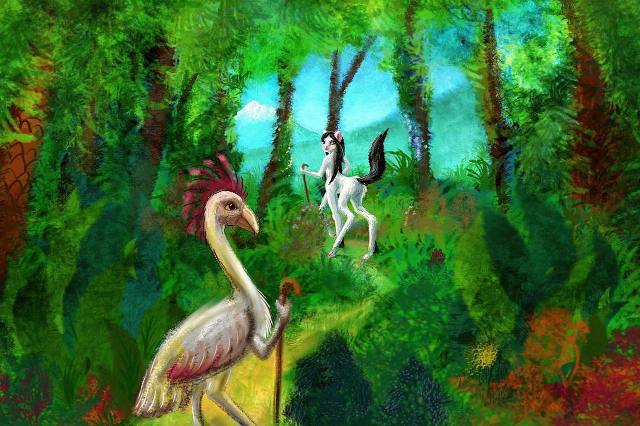
On a rare clear day (tropics, rainy, cloudy) the mountains of the Isle of Vityaz are probably visible from the Tuvalu Peninsula on Pacifica. My best guess is that natives of southern Pacifica will slowly follow the Vityaz chain west to Solomon, then fan out. The most common South Pacifican species is a large flightless avian, the kasowar, a bit more heron-like and upright than our Terran cassoway, and bigger-headed--holding a brain as smart as yours. Like most Abyssian birds, flightless or not, they have small forelimbs tucked under wings or folded over their breasts; limbs typically evolved to snatch insects, groom feathers, pick fruit... and wield tools. Kasowars can't fly the straits, and though they're decent swimmers for land-birds, they won't try to swim miles. They'll built boats. Or...
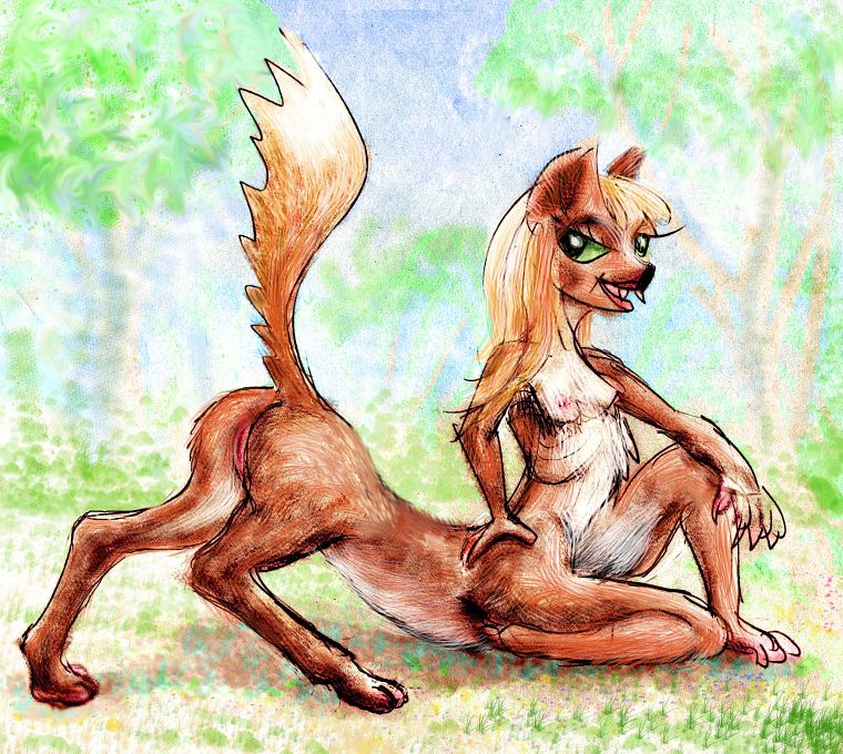
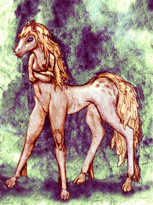
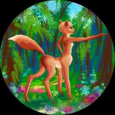
More likely they'll save up their labor-hour credits and book passage on someone else's boat. Kasowars aren't alone on Abyssia; not even on Pacifica. Dog-sized foxtaurs from the northern savannas and deserts, and deer-sized equi from the continent of Agassiz just to the south, are both fairly common in ports along Pacifica's southwest coast; they're confident sailors with long traditions of coastal trade all over the Pacific hemisphere. These species may well explore Vityaz first.
They won't quarrel over it. The two mammalian species favor drier, more open environments (they're quite human that way), while the kasowar are rainforest-adapted--one of the few Abyssian flightless birds to climb trees routinely.
Result: the Archipelago is spottily settled: drier coasts have mostly foxtaurs and equi, wetter coasts mostly kasowar, with only thin populations of eccentrics inland and at higher altitudes.
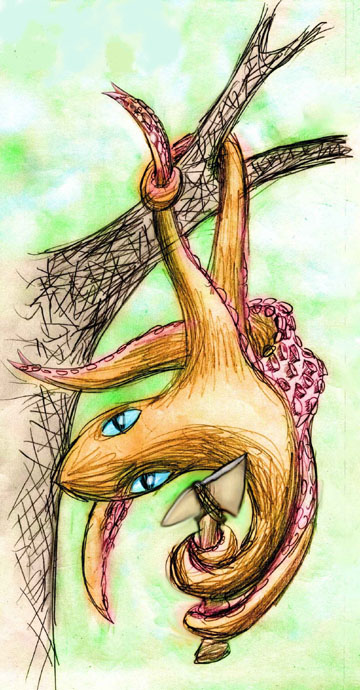
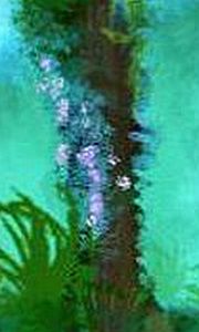
A fourth species isn't rare, just shy and little seen. Just as crabs in some parts of the Terran tropics have learned to emerge from the sea, climb trees and exploit fruits and nuts, a six-limbed Abyssian mollusc lives in mangrove swamps and on palm islets too small for the fresh water the other species need. Squid aren't strictly nocturnal, but are most active on land at night, retreating to the sea (or deep leaf-shade) in daylight, to avoid sunburn. These tree-squid can change color like terran octopi, and are hard to spot even in towns (unless they want your attention).
A tree-squid |
A foxtaur |

A kasowar |
An equa |
Unable to speak aloud (though they can all hiss, and some have taught themselves to whistle) they communicate via sign language--or, with strangers who don't know the local sign talk (sadly, it isn't standardized island to island, like the trade-tongue), treesquid can flash words on their bumpy skin. Most Abyssians of any species are literate in Trade so this is almost universally effective. But it takes hard work and concentration for the poor squid; sign is much easier.
For this reason, it's bad manners to ask strange squid to spell things out. Unless you're lost and really need it, don't! You might get inked.
You don't want that. Everyone will assume you're a rude, blundering tourist. For weeks. There's a reason sepia ink was used on Earth; the stuff is quite persistent. You won't just scrub it off...
Intro - Mtns & Deserts - Peoples - Carolinia - Meteora - Guadalcanal Is. - Vityaz Is. - Solomon - Vanuatu - Outliers
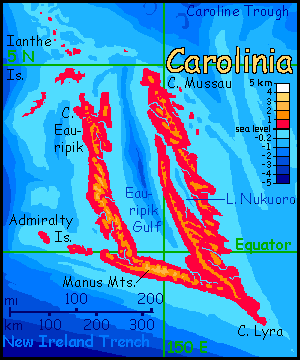
In our world, Carolinia is the East Caroline Basin, between the Caroline Islands and Papua New Guinea. That basin, inverted on Abyssia, forms a rise, but a peculiar one.
All the other big Vityaz islands are linear, paralleling clear trenches. Carolinia isn't and doesn't. I did say "clear"; there's a less-defined trough, in Eauripik Gulf, but it doesn't seem to be a branch of the trench system creating the other islands of Vityaz.
Carolinia is a stringy place, with long ridges at sixty-degree angles. This topography suggests a sort of diagonal argument between north-south and northeast-southwest drift (and probably compression); not surprising since Carolinia's on the edge of the north-moving Australian plate and the west-moving Pacific plate; and that collision is messy.
Carolinia is less mountainous than the southern Vityaz islands, but the compression-ridges rise as high as 2250 m (7400') in the southern Manus Mountains. Even this is barely high enough to rear above the tumbling sea of tropical clouds; while the summits do see some sun and are clad in grass and fern, the shoulder-ridges and foothills are smothered in cool, dripping cloudforest.
But then all Carolinia is wet and lush. The swampy lowlands on Cape Lyra and Cape Eauripik and around Lake Nukuoro are all unbroken rainforest--just hotter than the cloudforests, that's all. Sumatra reborn!
It's probable that the Ianthe Islands northwest of Carolinia will link it biologically and culturally to the southwest corner of Pacifica. And there's quite a deepwater gap between Carolinia and Meteora, its nearest Vityazian neighbor. So it might be more justified to treat Carolinia as a mere satellite of Pacifica, not Vityazian at all. But that continent is huge and its four tours already long and cumbersome. Vityaz is short. So here we are!
My guess is that since the population on the Pacifican coast north of Carolinia is heavily foxtaurean, the settlers island-hopping along the Ianthe Chain will also largely be foxtaurs. They'll settle the slopes and hills--still rainy, but at least not swampy. Kasowar are present if not numerous on the Pacifican coast, and will probably settle here along with the foxtaurs. They do well in rainforest as long as it's not totally flooded.
Tree-squid will predominate in the coastal lowlands and around Lake Nukuoro, where many places may seasonally cycle from rainforest to swamp under several yards of water then forest again.
Since the sea-passage from the rest of the Vityaz Chain north to Carolinia is so long, equi, common to the south, will (I suspect) be quite rare here.
Intro - Mtns & Deserts - Peoples - Carolinia - Meteora - Guadalcanal Is. - Vityaz Is. - Solomon - Vanuatu - Outliers
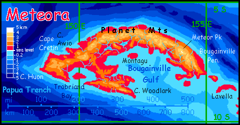
In our world, Meteora is Meteor Trench, a short but shockingly deep trench between New Guinea, New Britain, the Trobriand Islands and the Solomons. With altitudes reversed on Abyssia, those depths translate into impressive heights. Stretching some 750 km (450 mi), Meteora's a tropical twin of Sandwichia on the south end of the Atlantis Rise. It's a rugged island in a rugged region--to the northwest, past Carolinia, rise the highest mountains in the world, the Marianas; to the southeast, the second highest, the Tongas and Kermadecs.
Meteora's mountain arc rises only two-thirds as high as those great mainland ranges--over 4000 meters (around 13,500')--just tall enough for occasional winter snow, even this close to the equator. The mountains' flanks are smothered in cool, dripping cloudforest but the peaks normally rise well above the clouds. Three seasons of the year, Meteora's sky-islands seem like New Guinea's famous equatorial highlands--mild, sunny but still well-watered hills, enjoying a pleasant, near-perpetual spring--except when winter gets cranky. Those few degrees south, off the equator, make a difference!
Lowland Meteora--the coasts, the hills around Trobriand Bay, and the Woodlark Peninsula--are hot monsoon forest, as steamy as lowland Carolinia much of the year, but with several sunny dry winter months. Tourist season!
That is, if Abyssians share human pluviphobia. And aren't we hypocritical critters! Love the fertility rain brings, but grumbling whenever a few drops fall on wonderful us... Abyssian feathers or pelts may shed rain comfortably, so they may not care.
They may just love that summer heat. Their comfort zone is likely to be warmer than ours. Abyssia has tiny polar and temperate zones; its people will have evolved in tropical heat and never faced ice. It's cold they'll dislike, even fear.
So on Earth, Papuans crowd into the sunnier, cooler highlands and shun the buggy, muggy lowlands; but on Abyssia, Meteorans settle the coastal jungle. They may visit the mountains for scenery in summer, (shivering a bit in the shirtsleeve weather?) but to relax they'll head back down to their homes in the steaming sauna.
Intro - Mtns & Deserts - Peoples - Carolinia - Meteora - Guadalcanal Is. - Vityaz Is. - Solomon - Vanuatu - Outliers
This archipelago linking Meteora and Solomon is much like Meteora's Woodlark Peninsula--that is, like our lesser Hawaiian Islands, but a bit rainier, since we're a bit nearer the equator. The largest is Lavella, about the size of Maui; several others rival Oahu, and at least twenty are large enough to be habitable. All are wooded, but the lesser Guadalcanals are open woods patchy with brush, while the largest like Lavella have luxuriant monsoon forest, especially on windward (south) slopes; the higher the hills, the more clouds and rain an island snags.
Intro - Mtns & Deserts - Peoples - Carolinia - Meteora - Guadalcanal Is. - Vityaz Is. - Solomon - Vanuatu - Outliers
Su'uholo, westernmost of the Vityaz chain, is a hilly island nearly as big as Hawaii, shaped like a boat under sail. The northern 'sail' is a rainforested plain almost as wet as our lowland New Guinea; the southern 'hull' is hilly, cooler, and varies from rain- and cloud-forest to (relatively) open slopes.
East of Su'uholo lies long narrow Duff. Like Su'uholo, Duff has east-west ridges, part of the boundary between the Australian and Pacific Plates. It's surprising that none of these hills are much over a kilometer. Still, Duff is equatorial enough that spinelessness isn't a problem. Rain falls without coercion!
Vityaz and Alexa are distinctly further south, far enough to need a little help snaring rain. Fortunately they're both rugged; those hills snag (and generate) clouds. The south shores are as lush as Meteora's; the north, groves and savanna and brush.
These hot but less humid shores will definitely attract equi--a gracile, rangy, heat-adapted subspecies. What draws them isn't so much physical comfort--the forests to the north add humidity, but their shade mitigates the heat too--as emotional. Equi like a long view. Their ancient ancestors were born to run; quite unconsciously, they want to see if anything large and toothy is creeping up...
So they find these rugged, open slopes (that we might find a bit barren) serene. They breathe free--without quite knowing why.
The Eaglestone Islands are far enough from the equator to have a drier climate; and, unfortunately, they are very low. Without hills to push the drier air up and cool it, condensing clouds, the islands get few and irregular rains. Most inhabitants probably live on the coasts, exploiting the extensive reef. Fish-paradise! I'd bet they're mostly foxtaurs and kasowar, who thrive on fish. While equi wouldn't mind the climate, and aren't true herbivores like horses, they find too much fish both stinky and indigestible.
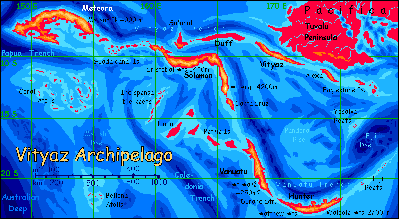
Yosalva or Yasawa Reef (spellings vary for the equivalent deep in our Pacific) is far from all other lands, but I'm mentioning it here because Yosalva's nearer Eaglestone than anything else, and is geologically related. The Vityaz and Tonga Trenches meet at a sharp angle to the northeast, pushing up coastal ranges on southern Pacifica and Agassiz; but this can't relieve all the pressure on these fast-moving plates. Yosalva, caught right in the elbow, has been squeezed up like a slippery seed. It's a short arcuate ridge rising from deep water indeed: 7 km (23,000') in the the Fiji Deep.
Like the Fiji Reefs further south, Yosalva's islets are green with palms and other salt-tolerant trees, but are mostly too small to have reliable fresh water for permanent settlement.
Human settlement, that is. Abyssians, who may be foxtaurs or equi or air-adapted octopi or huge flightless birds, may not need much fresh water; maybe none.
Intro - Mtns & Deserts - Peoples - Carolinia - Meteora - Guadalcanal Is. - Vityaz Is. - Solomon - Vanuatu - Outliers
Solomon could be considered two long islands joined by chance--or plate tectonics. Here the Vanuatu Trench, the longest in the Vityaz complex, has a sharp elbow. We call these island arcs, and generally they are--southern Vanuatu has classic curves--but Solomon represents a sort of T junction.
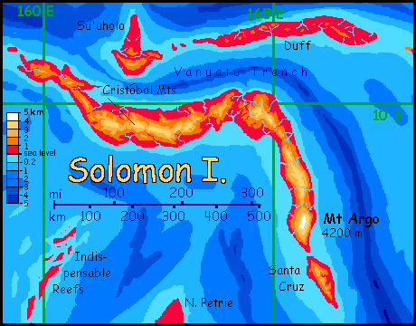
It's not alone--off Fiji (nearby, as the tsunami rolls) there's a nearly identical sharp elbow. Vityaz is where the Australian Plate is slamming into Pacifica's, and Solomon is where all these forces focus.
Not surprisingly, then, it's the ruggedest island in a rugged chain. The Cristóbal Mountains on the northwest half of the island reach over 3400 m (11,200') and Mt Argo in the south tops 4200 m (13,800'), comparable to Mauna Loa or Mt Shasta, taller than Fuji. These mountains are likely volcanic and certainly are seismically active--still growing.
The great height of the Cristóbal Mountains climatically isolates the north coast from the rest of the island. The mountains cast a rainshadow; the north shore is rocky, with cactus, dry brush, and twisted little trees that bloom madly in a good year and brown in a bad. As untrustworthy as our Galapagos--or Los Angeles. Yet again, I expect equi villages along creeks, wherever there's a long view--for them, peace of mind is well worth the effort of irrigation.
Yet if you trek just a few miles into the hills (take raingear!), you'll be floundering blind through a cloudforest; higher still, you'll emerge into sunlight again on fernfields and high alpen meadows, for these peaks (like Hawaii's) face winter freezes and occasional snow. Over the summit ridge to the south, the slopes drop quickly into rainforest, humid and fragrant (well, reeking of fermented mangoes for a month or two. Definitely the off season.)
Intro - Mtns & Deserts - Peoples - Carolinia - Meteora - Guadalcanal Is. - Vityaz Is. - Solomon - Vanuatu Is. - Outliers
South of Solomon is Santa Cruz: a modest island just 125 km long and up to 50 wide (75 by 30 mi), green throughout; an oversized Oahu where both sides have a Honolulu climate. Why? This island's dorsal ridge happens to be oriented so storms don't slam into it, creating a rainy and dry side as on north Solomon, but blow along the ridges, watering both sides about equally; plenty of water for open forests with occasional meadows. No jungle, but no deserts either.
Vanuatu, to the south, is a scaled-up version of Santa Cruz; its mountain spine is much higher, sustaining cloudforests, but it too slices through the prevailing winds rather than presenting a major barrier; storms run down both long coasts. Not too wet, not too dry: juuuust right.
My sources disagree sharply on how high these mountains get; most have Mount Maré at 25-2700 m (8-9000'), but one sounding in my newest National Geographic atlas would make it over 4200 m (13,800')--as high as Meteor Peak or Mount Argo, and possibly the highest in the whole region; certainly high enough (and far enough from the equator) for the most extensive winter snow--just a few miles above the mango and avocado groves on the coast!
To the southeast, Hunter Island is more diverse but less fortunate; the Vanuatu Trench curves slowly but relentlessly, until, on Hunter, the central Matthew Mountains stand across the winds. The south shore is rainforest, but the northwest coast is drier, opening into savanna in places; and in eastern Hunter, behind the Walpole Range, the north shore is true desert.
The Fiji Reefs, northeast of Hunter, are the last gasp of the ridge paralleling Vanuatu Trench. Fishing is rich around this atoll, but its coral islands, while large and rainy enough to have solid ground cover and extensive trees, don't have much reliable fresh water. Most years life here is pleasant, but in droughts it's coconut milk or nothing; and the islets are so low that every few years a storm-surge sweeps right over them.
Intro - Mtns & Deserts - Peoples - Carolinia - Meteora - Guadalcanal Is. - Vityaz Is. - Solomon - Vanuatu - Outliers -
The Petrie Archipelago
is a cluster of low islands straggling between two great trenches--the Vanuatu and the Caledonian. The largest, Huon, at the west end, is fully 160 km long and half as wide (100 by 50 mi; larger than Hawai'i). The lack of relief is a problem at this latitude; there's a long dry season and rains are irregular. The mountain ridges typical of the Vanuatu region snag at least modest rains year-round, but as the interiors of the Petries lack such raincatchers, they're scrubby and semi-arid.
I don't know what species the local Abyssians are yet, but I'll bet they live mostly on the coasts--unless you're a Galapagos tortoise, a lifetime diet of cactus sounds tedious. Offshore are broad coral reefs; while the Hawai'ian Isles rise from deep water and have rich but narrow reefs, the Petries ride on the back of a broad rise. People, whoever they are, will fish (or eat nori, like the Japanese, or algae, as marine iguanas do. It's naive to assume all intelligent species will be carnivores. Still... I like seaweed, but seaweed alone sounds as tedious as cactus to me.)
The Indispensable Reefs are classic Pacific atolls--a ridge uplifts between two trenches, breaking out in volcanic pimples here and there. Many of these get close enough to the surface for coral to grow. The resulting reefs stretch hundreds of kilometers, but dry land is not extensive--narrow islets ringing lagoons. Some islets are wooded but very few have fresh water. And the Indispensables are, like the Fiji Reefs they resemble, vulnerable to storm-surges and tsunamis.
The Coral Reefs: the blandest name on Abyssia, but unavoidable--it's the floor of our Coral Sea. If I went strictly by the soundings, this rise would be a vast tablemount never quite breaking the surface, with just a couple of clusters of shoals, the Lihou Reefs in the southeast and the Coringa Reefs in the west. But this is prime coral water (just east of our Great Barrier Reef, remember) so the coral will patiently build up to the surface; barrier islands will eventually develop around ring lagoons.
But the islets of Lihou and Coringa--and lesser atolls elsewhere--won't necessarily be large. Summer rains are copious, but the porous coral rock won't hold it; fresh water will be scarce. If you get stranded, it's coconut milk. A lot of it; you may be stuck a long time. If Abyssians are humanlike--land dwellers needing fresh water--they may not settle here. In most years these islets are pleasant; but communities would fail in a drought and drown in a stormsurge or tsunami.
Still, I doubt Abyssians will have our continental flaws. This is an island world. Whether Abyssians are reefdwellers or land-animals recently risen from the sea or aepyornises with hands, they may be semi-aquatic, or not need (much) fresh water to survive.
The Bellona Reefs face a double curse--isolation and latitude. The nearest land is 550 km (330 mi) to the south: Middleton Island in the Tasman Archipelago. And at 22° south, Bellona's islets are in a high pressure zone. The reefs boom with life, but above water it's harsh. Heights like those of Middleton or most of the Vityaz islands might snag rain, but the Bellonas are small and low--no more than bare rocks. True desert islands! White with nesting seabirds for a couple of months, then white with guano the rest of the year. Not even much grass survives.
And that's the optimistic picture of Bellona. Many of the atlases I've consulted would have a mere guyot here--a coral-topped mesa whose shoals never broach the surface at all.

Abyssia's homepage - map - peoples - regional tours - names
LISTS AND LINKS: More worlds? Planetocopia! - dreams of other worlds - ecology - climate change - evolution - natural disasters - terraforming - sculptures and 3D art -
World Dream Bank homepage - Art gallery - New stuff - Introductory sampler, best dreams, best art - On dreamwork - Books
Indexes: Subject - Author - Date - Names - Places - Art media/styles
Titles: A - B - C - D - E - F - G - H - IJ - KL - M - NO - PQ - R - Sa-Sk - Sl-Sz - T - UV - WXYZ
Email: wdreamb@yahoo.com - Catalog of art, books, CDs - Behind the Curtain: FAQs, bio, site map - Kindred sites