
The Amazon Ocean
for... I dunno yet
Skeleton only!
by Chris Wayan, 2006-2025
more planets: Planetocopia -
(under construction--don't click yet) Inversian geography and climate - Evolution on Inversia - Creatures and peoples - Regional tours - Gazetteer -
Introduction - Islands - North Shore - Wet Northeast - Dry East - Rio Grande Sea - Southeast - Patagonian Gulf - Southwest - Northwest

This ocean, five or six times bigger than our Mediterranean, or half again as large as our Arctic, is a nearly unbroken triangle of sea--shallow and full of coral reefs, except along the Andes Trench in the west. Dense air in the basin, nearly 1.7 atmospheres, make most of it extremely hot and humid. The tropical sea (and that's most of it) is under perpetual cloud cover, with back-to-back hurricanes. The Patagonian Gulf is subpolar, but even it is mild.
Good-sized animals here can fly. The dense air makes it easy to get aloft, whether on stubby feathered wings, skin flaps or big fins. Maximum flight weight is 25-30 kg (55-65 lbs). People here, whether they're gliderwolves or megaparrots, will have easy access to treetops; they won't clear forests but cultivate them. The coast may be one great orchard, broken only where the rains fail.
The steep, rugged west coast is consistently green, except in the far south, in the Patagonian Gulf.
The east coast is drier and more diverse. The basin's so muggy that even this coast has a lot of cloud cover. But prevailing winds will be off the highlands of Atlantis. This doesn't mean no rain; Atlantis is narrow, and has the world's biggest ocean beyond it, and has huge, high lakes--freshwater Mediterraneans, essentially--which should partially rehumidify the air passing west over it. My best guess is that the shore will be lush down to 15° south, then drier but by no means desert. Savanna, dry most of the time, but bursting briefly into life when tropical storms stray onto land--more Senegal than Atacama.
On the southeast shores, say past 30° south, a Mediterranean climate is likely--dry summers, winter rains. But hotter than Earth's: mild winters, never freezing. The air's just too dense.
Far south, past 40°, the broad low plains on the east coast of the Patagonian Gulf should be quite green, since at these latitudes prevailing winds swing round to blow from sea to shore. Dense forests and gigantic trees--possibly the tallest on the planet.
Introduction - Islands - North Shore - Wet Northeast - Dry East - Rio Grande Sea - Southeast - Patagonian Gulf - Southwest - Northwest
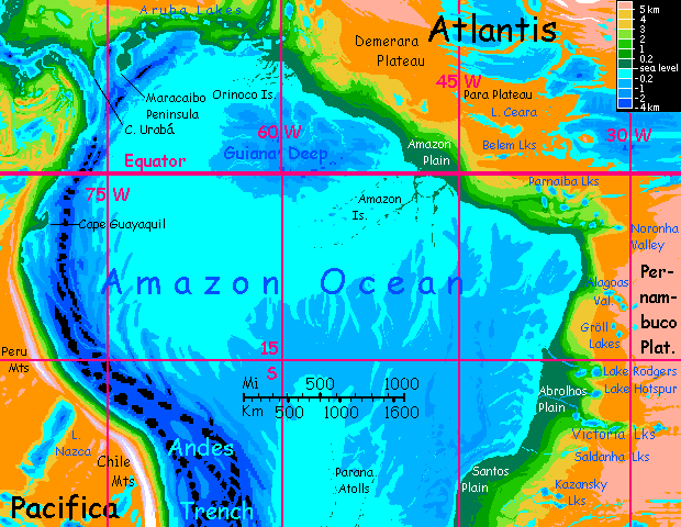
In the tropics, the only islands (or even reefs) are the Orinoco and Amazon chains. On Earth, these two great rivers have beds deep enough in their lower stretches to be under sea level; so Inversia has atolls for hundreds of km off the northeast shore; and coral reefs extend some 2000 km west (1250 mi), near the equator.
In the southeast, similar reefs and islets extend hundreds of km off Cape Plata in Argentina.
Farther west/offshore from Cape Plata, what about the salinas behind the Córdoba Range? Judging by their altitude on Earth, they'd be mere sea-rises as much as a hundred meters down.But I bet they don't stay that way. On our Earth there's a host of seamounts that deep, suggesting to the naïve eye that coral can't build to the surface from that depth--not enough light. But that's false; if you face the reality of climate change, all those seamounts were, ten or twenty thousand years back, at sea level. The Ice Age ended, the sea rose, and the coral hasn't had enough time to build back up to the light. It will eventually--if we give it time and don't change the sea level again, as we seem to be hell-bent on doing (to our own grief). The fact coral has already built up to the shallows on so many reefs is fascinating--why some, not others? But give them time, and they all will.
And here in the Amazon Ocean they did long ago. The sealevel and water temperature are fairly stable; corals will have built up to the waterline; the Córdoba Atolls.
Do the Bariloche Islands rise in the center of the Patagonian Gulf? On Earth, some of those ice-gouged mountain lakes are deep. But deep enough for islands, not just reefs or coral islets? Tentative bathymetry says no, but as with Córdoba, I've put small coral islets on the map (about 40° south).
South of Cape Plata, the low, coast-hugging Patos Islands create a sheltered inland waterway and several harbors safe in all but the worst storms (and most fade out north of Capa Plata).
In the southwest, Patagonia's western shore is an intricate tangle of islets, sounds, and fjords, just as it is in our southern Chile... except of course this region is far warmer than Earth's Patagonia, so the cause can't have been ice. And what we see aren't fjords, but anti-fjords--rugged winding ridges, like crazy masons have built branched meandering walls going everywhere and nowhere, cupping endless deep lakes instead of bergs. This maze of a land is smothered in rainforest--by definition not tropical, not at this latitude, but it never freezes--even at 50° south, the dense air keeps the temperature mild.
I can't think of any Earth equivalent to this jungle maze; curiously, there's a close parallel on Venus, in the "tesserae" on the upland of Tellus (remember, while I've terraformed my online Venus model for your touring convenience--too many charred tourists, too many lawsuits--I haven't altered the bizarre terrain). Exactly the same net of walls or raised roads around deep, regular lakebasins--not just a swiss-cheese landscape, but reticulate as lace.
This isn't the first time in the tours I've noted funny symmetries between Venus and Earth-turned-inside-out. I suspect it won't be the last. The only reason I can propose is... under their trivial climatic difference, Earth and Venus really are twins, and we forget that TWO broad factors shape surface features--internal geologic vigor, and erosion. Earth's strong winds and rains maximize erosion, erasing many features. Venus, in its dense but relatively windless air and rainless clouds, lacks erosion, so its landforms are utterly different. Or so we think. We're wrong! We're land-animals with land-bias. Undersea, erosion's minor--and Inversia bares just that uneroded face of Earth. No wonder some parts look like Venus! Earth is way more Venusian than we land animals know.
Introduction - Islands - North Shore - Wet Northeast - Dry East - Rio Grande Sea - Southeast - Patagonian Gulf - Southwest - Northwest
From the mouth of the Panama Strait we sail east along the Caribbean shore. Monsoon forest, relatively dry now in winter--storms only every third day!
Why winter? Well, in summer you'd be dead.
Low, flat Maracaibo Peninsula--one great orchard.
The Aruba Lakes--a long valley roughly parallel to the coast, lake-dotted. Not cut by a river; half the trough drains west toward Maracaibo, the rest east. Several east-west ranges of hills parallel the Lakes, suggesting geologic compression. The Caribbean Highlands to the north have huge east-west ranges and trenches; this is just an echo out at the fringe.
A day east, to the Antilles Lakes, running north along a great trench-valley, 2-3 km deep (7-10,000'). Volcanic vents deep in these lakes belch carbon dioxide. It's not dangerous; these are big, deep lakes and can absorb a good-sized eruption--bubbling and fizzing like a monster cola, but not a dense, continuous layer of CO2 stifling animal life along the shore--which has happened to a few small volcanic lakes on Earth.
Squarish Lake Trinidad, broad and shallow. Above it, to the northeast, broad lake-dotted slopes rise for hundreds of km--the Barbados Lakes.
Southeast now along the Guiana Coast. Wetter; year-round rain, not just a summer monsoon.
The Marajó Plain. Above it to the northeast, the Amazon Amphitheater, a great scallop 3-500 km across. Above lies long Lake Ceara, with a cooler, refreshing, merely Earth-equatorial climate. I long suspected Lake Ceara drained the freshwater St. Paul Sea, part of the chain of high-altitude lakes along our Mid-Atlantic Rift; the sill down to Lake Ceara is 4.3 km up. But it looks now like two sills are 1-200 meters lower: one drains Lake Sierra Leone into St. Paul Sea; the other is much like Ceara Pass but still 1200 km (over 700 mi) ahead--Parnaiba Canyon.
Belém Valley, right on the equator. Another lake-chain along a deep linear canyon--a fracture zone, one of many in this kinky stretch where the Mid-Atlantis Rift bends sharply. Slippage, cracks and tucks.
The Parnaiba Lakes, a cluster of anti-volcanoes--deep lakes occasionally belching carbon dioxide. To the east, straight, narrow, spectacular Parnaiba Canyon cuts deep into the flank of Atlantis. Waterfalls, big ones--the flow's huge, astonishing--how big's this watershed? A few days in, you reach 4.2 km (13,'800), still in the canyon--it's water-shaped but born of the same twisting and cracking that creade Belem Canyon and the pass above Lake Ceara. If you keep hiking a couple of days, the canyon floor's nearly level, the river lazy--but still huge, and with only small side streams leaping off the cliff walls in Yosemitish falls. At last the walls pull back, and the river widens, until... it's not a river any more. Huge Lake St. Paul, a freshwater high-altitude sea--Lake Titicaca times a hundred. As big a basin as our Orinoco, and with Sierra Leone Lake feeding into it like the Black Sea into the Mediterranean; Sierra Leone's nearly 4.3 km up (14,000'), about the highest of these Atlantean lakes. I think! Determining these sills from upside-down bathymetric data isn't easy--or accurate.
Noronha (pronounced Noronya) Valley, cutting even farther and deeper into the flank of Atlantis. But its river is a modest stream--it dead-ends in the Romanche Mts and Pernambuco Plateau. There's zero chance it drains a stretch of the Atlantis Rift. The lakes of South Atlantis are just as big as the northern ones, but they're well to the east--farther from Amazonia. Atlantis not only bends, in a sinuous S-curve, it bulges. By 5° south, it's twice as wide as at 5° north.
That continental bulge has consequences--south of Noronha Valley, less rain falls. Up to now it's been torrential, so at first it doesn't matter. But soon... it will.
Introduction - Islands - North Shore - Wet Northeast - Dry East - Rio Grande Sea - Southeast - Patagonian Gulf - Southwest - Northwest
"Wet" is relative. The north coast was drenched. This stretch is wooded, getting perfectly adequate monsoon rains from the Amazon Ocean. But winters can be quite dry. Inland the Pernambuco Plateau, well over 5 km high (17-18,000') blocks most rain from the Ascension Sea--unlike the north coast, which lacks such a barrier and got rains off both the high Atlantean freshwater seas and the low, steaming Amazonian. Feast and famine! But not total famine--not yet.
Alagoas Lakes. A chain of hanging lakes, like Noronha Canyon, but shorter. The lowland coastal strip is narrow here; the flanks of trhe Pernambuco crowd the Amazon Sea, rising quickly into Terran climate; indeed the highest of the Alagoas Lakes have air pressure and temperatures like Earth's tropical highlands, a mile or so up. And cliffs around them rise another km.
Recife Shelf, a sweltering lowland like Maracaibo, between two hill-spurs from Pernambuco; 160 km (100 mi) of fatally hot coast. Don't visit. Sail well offshore, sit in a tub of seawater, and pray the winds don't fail.
The Gröll Lakes--at 4.3 km (14,000') the highest on the highland's outer flanks. Again, cliffs rise round the highest, Lake Stocks and L. Gröll. There's no easy river route leading up to these; the coastal mountains are relentlessly steep, followed by a long trek inland over a thin-aired plateau. Not recommended; even for natives, it's tricky flying up a narrow canyon to lakes so high they gasp for air--and out of shock at having to (shudder) walk.
Introduction - Islands - North Shore - Wet Northeast - Dry East - Rio Grande Sea - Southeast - Patagonian Gulf - Southwest - Northwest
Ah, but how dry? That hurricane generator to the north--a warmer sea than our equatorial Atlantic--swings north in winter, leaving the coast sunny and dry--but it swings back south in summer, dumping monsoon rain.
Abrolhos Plain--as we pass 15° south, the coast widens, but grows scrubby and fireprone, as the rains get briefer and less reliable . Wretchedly hot; few shade trees. Do NOT explore this plain at ground level! Rent wings, catch a thermal (in this dense air, hang gliding's easy) and ride the updrafts inland to...
Abrolhos Scarp. Massive waterfalls as high as Angel. Above, hanging valleys with very deep lakes: Minerva, Rodgers and Hotspur. But while locals can just barely fly up there--air pressure's like Terran sealevel--it's too thin for you to manage. Next time, get born with hollow bones.
From 20-30 south, monsoons off the Amazon Ocean are rare; winds blow mostly off the land. What rain there is comes from the upland seas of South Atlantis far to the east--this is the widest and highest bulge of the Pernambuco Plateau.
This coast is hot savanna, with trees only along watercourses. Deep life has evolved to be comfortable at 50°C (122°F) and uncomfortable (but alive) at 60 (140°F). Earth life has not.
Vitoria Valley, cutting deeper into the the Pernambuco highlands than any other: nearly 1000 km east, with walls more than 2 km tall in spots (nearly 7000'). Lake-chain: Champlain and Vitoria, Montague, Lake Jaseur, lower and upper Columbia, and Vaz, cupped between ridges up over 5 km up (c.17,000'). With effort, you can get halfway up--to Lake Jaseur, about 1.8 km high (6000'); about 1.2 atmospheres. Warm to hot, but not dangerously so. They're not unlike the Peruvian coastal valleys where irrigated farming worked well. Not bone-dry--the mountains blocking rain from the east aren't much higher than the seas generating that rain, so there will be some spillover in winter. Plus, the Amazon Sea below is warmer, the air more humid... stray thunderstorms in summer. Still, the fields and orchards you see are irrigated.
Widest of these valleys are the Santos/Sao Paulo shelves/Vema shelves--a triangular region 1000 km by up to 500 (640 by 320 mi). Latitude (and climate) resemble San Diego. Annual rainfall is modest and Mediterranean, half a meter or less (15-20"), but the altitude moderates the heat to Californian warmth, and rains from both seas grow more frequent as we hit 30° south--summer thunderstorms off the Tristan Sea, winter rains off the Amazonian.
Introduction - Islands - North Shore - Wet Northeast - Dry East - Rio Grande Sea - Southeast - Patagonian Gulf - Southwest - Northwest
Off Uruguay, our world has a mountainous knot called the Rio Grande Rise. Inverted, I'm forced to call the result the Rio Grande Sea. A misnomer in every way--there's no river (grand or not), and it's not a sea but a freshwater lake big as France, hanging 4 km high on the rim of the South Atlantis highland. For years I assumed it'd be somewhat smaller and lower, draining west into the Amazon Sea around 30° south. Big river, and a highland basin just low enough for Amazonian fliers. A land between.
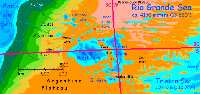
But looking closely at the complex terrain around our rise shows (when inverted) three possible sills, all of them over 4 km high, not in the high 3s as I thought:
Sigh! Just another lobe of Atlantis after all.
Introduction - Islands - North Shore - Wet Northeast - Dry East - Rio Grande Sea - Southeast - Patagonian Gulf - Southwest - Northwest
Earth has wide continental shelves off southern Brazil and Uruguay. These invert to become broad fertile coastal plains. Tropical heat by Earth standards but Mediterranean climate, with a dry summer--too hot for humans, but the heat-adapted fliers of the Basin will find it mild, pleasant country.
Cape Plata. A huge triangle of lowland--groves and meadows. Now, in winter, it's merely Terran-hot.
Off the tip of Cape Plata, in the middle of the narrowing sea, are two chains of coral islets--the Paranás and the Uruguays.
South of Cape Plata, the low, coast-hugging Patos Islands create a sheltered inland waterway and several harbors safe in all but the worst storms (and most fade out north of Capa Plata).
Azul Bay and its still-warm but rainier shore. The winds are shifting, coming most of the year from the west off the sea here. A narrow sea, but bath-warm; rainy winters; drier summers, but no totally dry months as in the Mediterranean zone we just left. We're creeping into...
Introduction - Islands - North Shore - Wet Northeast - Dry East - Rio Grande Sea - Southeast - The Patagonian Gulf - Southwest - Northwest
Our Patagonia is narrow--from Buenos Aires across to Santiago is just 800 miles, and the wedge quickly narrows to a few hundred--and it gets dry (and often salt-poisoned--it's only recently been heaved up out of the sea by the still-rising Andes). Cold, windy and dry on the east, cold windy and wet on the west. Patagonia is the only barrier to a ring of circumpolar winds blowing relentlessly. It's a harsh place and not too fertile.
In contrast, I think most Terrans will find this the most pleasant part of the Amazon Basin; the eastern shore of Inversia's Patagonian Gulf is gentle, fertile, and wide--a lowland plain as wide as our whole Patagonia, when you add in the great valley of the Falklands with its twin lakes. The west coast, while narrower, is still as wide as Chile, and island-dotted; all in all, there's more coastal lowland in Inversia, and it's warmer. More evenly distributed rains, too: the deep-sunk Amazonian Ocean, warmed by its greenhouse, is much warmer than our seas and generates quite a bit of rain even at higher latitudes; mountain walls block the subpolar winds that blight Earth's far south. Temperatures are subtropical on the plains, and mild to temperate on the extensive slopes below the Argentine Plateau, a sort of muted Tibet, with some icy ranges, but mostly rounded hills and plateaus--high, treeless alpine prairies.
The plain does narrow at last. At the southern tip a hundred km past the shores of Lake Fuego...
Major rivers flow into the head of the Patagonian Gulf, but their flow may be modest, not Amazonian as I once thought. The high-altitude, freshwater South Atlantis Sea, really two gigantic freshwater lakes, won't drain through the Scotia Valley down to the Gulf of Patagonia; there's a lower sill spilling down to Angola, on the African Ocean. Instead we'll have the more modest Taitao, Penas, Horn, Burdwood and Malvinas Rivers, draining the northern Scotia Plateau and parts of southeast Pacifica; a couple of million square kilometers, but not a continent-sized basin as I thought.
South and southeast of Lake Fuego lies the strange highland of Scotia [don't click yet!], cut off from Atlantis and Pacifica on three sides by high mountains and huge lake-dotted valleys, and mostly lower and warmer than those two chilly to icecapped uplands. While it's only a million square miles or so, this region deserves its own page; Scotia is one of Inversia's few regions with a climate much like Earth's at this latitude (rather Nordic); the heights are icy, but the valleys are warmer than sea level on Earth, creating a long, habitable U-shaped path between icecaps to the (also) rather Nordic (but mostly ice-free) Antarctic Basin.
The Scotia uplands have a jumble of mountain ranges from Alpine to Himalayan, which will glaciate at this high latitude. Megatons of glacial silt will pour down the Scotian rivers into the Patagonian Gulf. This cold fresh water first sinks to the floor of the salty but bath-warm sea--the temperature difference is greater than anything on Earth. As it warms, it becomes lighter than the surrounding brine, and rises, dragging a fraction of the silt with it. A counterclockwise surface current spreads these nutrients to the Amazonian Ocean's warmer northern waters, feeding coral growth.
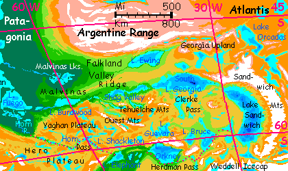
Scotia is by far the biggest gap in the ice wall between the Antarctic Basin and the rest of the planet. Still, it's not an easy sail or portage or even caravan trek. Looking closely, I've concluded that the Shackleton Valley shortcut will be a better path for travel to/from Antarctica than the long Sandwich Valley to the east. Both are arduous climbs, but ice-free. Shackleton's much, much shorter--a (fairly) straight notch from the Antarctic Basin around Lake Elephant up the Shackleton Valley, over Horn Pass, 3.6 or 3.7 km (around 12,000'), and down to Lake Fuego. However, the long route through Lake Sandwich may be navigable by boat as far as Herdman Pass, 4-500 meters lower than Horn Pass and possibly even flyable for natives of the Deeps. So unhurried travelers and non-perishable cargo may take this eastern route; flyers on deadline may be forced to flap up Horn Valley to exhaustion, trek or sail the alpine Shackleton Lakes, and glide down into sweet Antarctic air.
Of course, all this presumes that Inversians haven't mastered steam power. If so, Shackleton's certainly the easiest route linking the huge Antarctic Basin to the rest of the world. I think they'll do it.
Introduction - Islands - North Shore - Wet Northeast - Dry East - Rio Grande Sea - Southeast - Patagonian Gulf - Southwest - Northwest
The southwest coast is fractal at first: a maze of ridges, lakes and isles 1-200 km wide. Inland, though, it's simple--the Chile Mountains abruptly rise over 4 km (around 14,000'); the same range forming the west side of Shackleton Valley. The Chiles curve gradually for some 800 km (500 mi) until they're running due north.
Here they sag, forming a broad gap from 50-44° south (say 640 km / 400 mi), letting two major rivers from deep in Pacifica reach the sea.
From the southwest flows the Penas River, draining a high, cold basin, perhaps like Alaska's North Slope (but bigger) full of great turquoise milky lakes, opaqued by glacial flour from the Mornington Ice Cap.
From the northwest runs the clear Guafo River, from cool but ice-free high prairies and lonely ranges: an otherworldly Montana (with a similar deep-blue mile-high Big Sky, too).
Around 44° south, the Chile Range rises again, steadily higher, 6-8+ km (20-27,000'). The shore at the feet of the great range changes too; at 42° south, the fractal coast abruptly straightens into a narrow coastal plain, mild and rainy in the far south, warming gradually to a torrential steambath in the north. The Chile Mountains (like our Himalaya during monsoon) force this dense humid air up until they've wrung most of the rain out of them. On the back side, Pacifica resembles Tibet or the Altiplano (though far bigger)--vast, dry plateaus. The air's not quite as thin--it's like Earth around 2-2.5 km up (7-8,000'). More Taos than Lhasa. But to the winged Amazonians, it's an alien world where they're grounded--mere land animals.
Our Himalaya has frequent ice-carved passes 4-5 km up (bared by our unstable, warming climate); but the Chile Range is an unbroken wall with no passes under 6 km (20,000') for some 3000 km (18-1900 mi). Amazonians can't fly and can barely breathe in that thin air, and caravans (or railroads, even if they have that technology) are impractical: passes are choked with glacial ice. So it's a lush wooded coast, but narrow and isolated; even more Chile than Chile. Effectively, to the west the world just ends.
Introduction - Islands - North Shore - Wet Northeast - Dry East - Rio Grande Sea - Southeast - Patagonian Gulf - Southwest - Northwest -
At 15-16° south, the Chile Mountains sag to a broad, ice-free saddle, the Nazca Pass, that's barely 4.5 km (a mere 15,000'). Amazonian flyers will have still to hoof it over the pass for a day or two, but the far side drops to the Nazca Sea, an arm of Rapa Nui Ocean, the world's largest freshwater sea. Arms of it poke all around eastern Pacifica; ship-passage may seem slow to fliers, but it's the best way to get around in Pacifica... at least until a railroad crosses the pass.
North of Nazca, slopes rise quickly again to the Peru Mountains, topping out over 6 km high (20,000'). Yet the passes and peaks are ice-free, and even free of winter snows most years; the air thins to the equivalent of about 3.5 km (11,000') on Earth, and we're creeping into the tropics now. Cloud forest and fern-fells, with a little winter snow, but not Chilean ice-peaks. Unlike the higher, colder Chiles, the Perus aren't a barrier due to ice; they're just impossible to fly over. The dense-air deeps are a narrow coastal strip again.
This stretch is dangerous, for hurricanes are frequent except in winter, and there's only one safe harbor of any size on this straight, severe shore--Guayaquil on the Ecuadorian coast at about 3° south. The port will be just a mile south of ours! Exchange land for sea, and you still get a curved cape sheltering a bay about the same size.
Jung always said the reverse of something often resembles it more than we like to admit, but he only meant it psychologically--didn't he? Yet it seems true of Inversian harbors--consider San Francisco, a similar haven on the straight western shore of the Canadian Ocean.
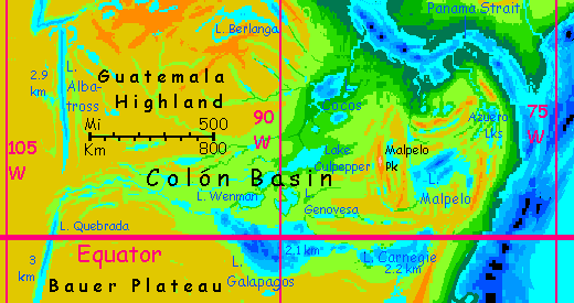
Another few days north, past the equator, the Peruvian wall breaks up for good. Slopes are more broken and both rain and dense air run hundreds of km inland. The Malpelo and Azuero basins are a jumble of twisted arcuate ranges and valleys--this is the joint between the Canadian and the Amazonian tectonic plates, and clearly the hinge has bent over eons, squeezing nearby crust; the sinuous Panama twist echoes over and over.
Rugged country, but pleasant--rainy and hot for us, but not a fatal sauna like the Colombian coast, 2-3 km deeper in the greenhouse. And yet the air's dense enough for fliers; an in-between country, not quite high- or lowland, and far more welcoming than the chilly Penas or dry Guafo basins.
These lake-dotted basins are just an eastern outlier of the gigantic Colón Basin to the west: the valley where the Rapa Nui Ocean finally spills down to the sea in a complex chain of great lakes, from one to three km high (3-10,000').
All together, this fertile, equatorial interzone is several million square km (at least 1M sq mi) where uplanders and lowlanders, fliers and runners, bird people and mammal people can comfortably meet. And do.

CLICK A REGION for local maps & illustrated tours. Many areas still lack tours, though. These are done:
Arctica -
Canadian Ocean -
Amazon Ocean -
Medimarea -
African Islands -
More worlds: see Planetocopia
World Dream Bank homepage - Art gallery - New stuff - Introductory sampler, best dreams, best art - On dreamwork - Books
Indexes: Subject - Author - Date - Names - Places - Art media/styles
Titles: A - B - C - D - E - F - G - H - IJ - KL - M - NO - PQ - R - Sa-Sk - Sl-Sz - T - UV - WXYZ
Email: wdreamb@yahoo.com - Catalog of art, books, CDs - Behind the Curtain: FAQs, bio, site map - Kindred sites