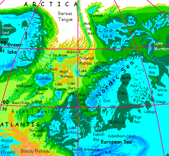
 Arctica
for... I dunno yet
by Chris Wayan, 2006-2018
more planets: Planetocopia
Inversia homepage - (not done, don't click:) geography & climate - evolution - peoples - map & tours
Arctica
for... I dunno yet
by Chris Wayan, 2006-2018
more planets: Planetocopia
Inversia homepage - (not done, don't click:) geography & climate - evolution - peoples - map & tours
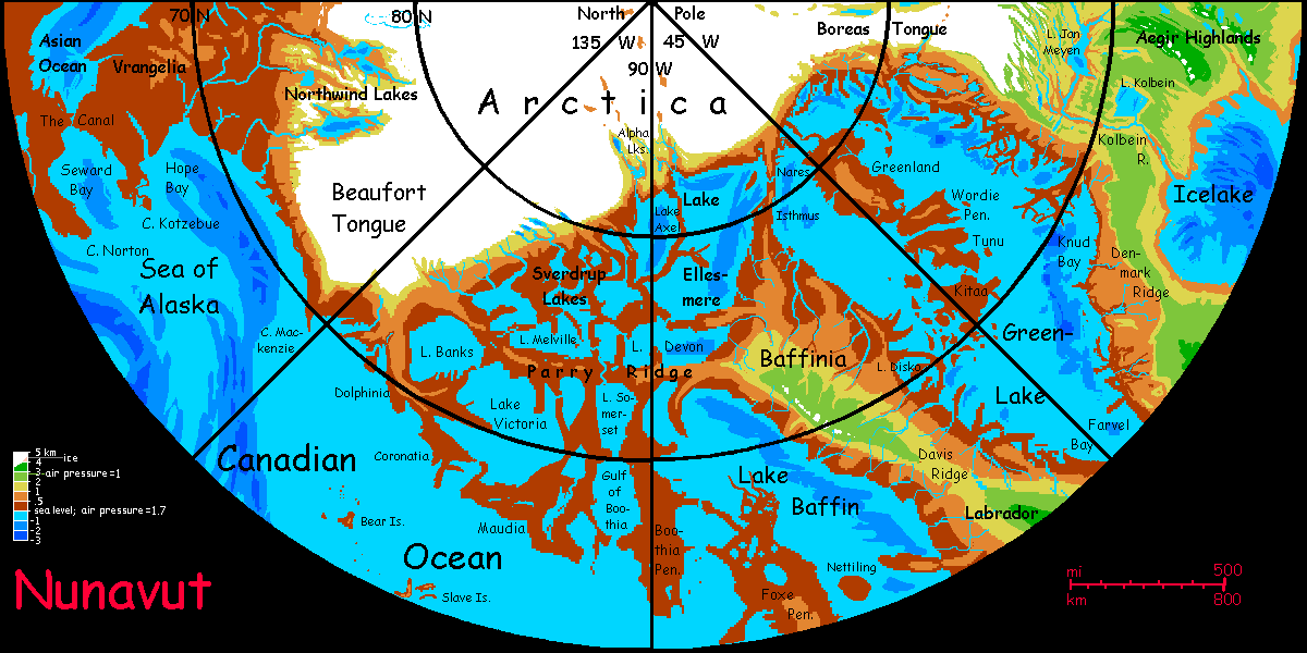
Welcome to Arctica - Biology - Norway - West Siberia - East Siberia - Beringia - Nunavut - Greenlake
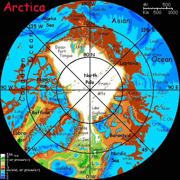
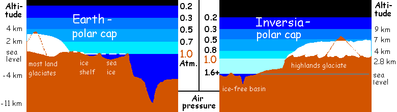
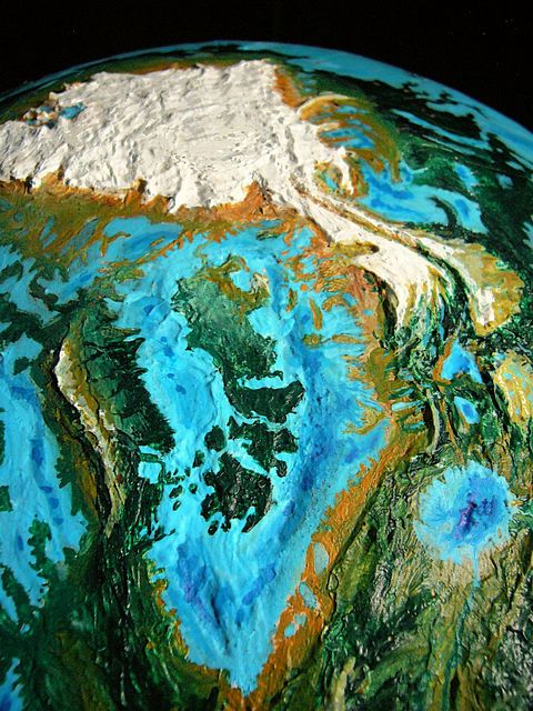
Arctica, at first glance, looks like our world's Antarctica--a big polar ice cap looming above the surrounding territory--and blighting it. But there are three differences:
The ground under our Antarctica is mostly at sea level; the ice builds up to about 3 km high (10,000' or so) and stabilizes; at that height the air's so thin, cold and dry that the little snow deposited just offsets/balances the slow glacial creep to the sea (or did, till we started burning fossil fuels). But Inversia's Arctica is a plateau already 3-4 km above sea level.
Given all that, you might expect the ice to be a mere veneer, less than a kilometer deep, even patchy, with whole mountain ranges or uplands scoured bare of ice by the cold dry Martian winds. Like Tibet in our ice ages.
But it's more complex than that. Inversia's sea basins have dense air; the pressure drops to Antarctic or Greenlandic levels only at altitudes of 5-6 km (16-20,000'). Below that height, the air transports enough moisture to deposit more ice. So the ice near the Pole has built up 1-1.5 km deep (4-5000') over most of the plateau, a bit over half Antarctica's average depth. Total ice volume: only 1/3 of Antarctica's.
And that ice isn't spreading anywhere. Warm ultradense air (1.7 atmospheres!) surrounds and contains the cap. Glacial tongues explore south, but as they drop below 2 km, both air and soil temperatures are just too warm; the ice melts out from under as well as above. Even though the icecap's triple the area of Greenland, the lowlands are a good 10°C warmer (18°F!) than comparable latitudes on Earth--basically, temperate.
So there's a wide skirt of polar grassland around the ice cap, kept treeless by the cold dry winds off the ice, just as in our Ice Age Siberia, Europe, and North America. But the parallel is superficial--literally. Dig into that dirt at your feet. Easy, isn't it? Keep going. That's because it really IS dirt. Dirt all the way down. You don't hit permafrost, you don't hit bog. This grassland isn't tundra! It thaws completely in summer, and always has. It has none of tundra's problems--drainage, upheaval, cracking. It's just a bit too dry and windy for trees. These lowlands are warm for the Arctic--and why not? They're 5 km below the ice, not just one or none. Like India below the Himalaya--another world.
Forests only 1000 km from the ice? This is quite unlike our Ice Ages--few portraits of those times sufficiently emphasize that they weren't just cold but dry. Forests shrank. But it wasn't the ice per se! Cooler climate means less evaporation from lowered, shrunken seas--two factors conspiring to lessen rain. Cold MEANS dry! But Inversian seas, deep-sunk, are warm and very rainy.
By the way, that's why my model of Earth after greenhousing, called Dubia, projects a greener world than most doomsayers; we Ice Age critters, looking at the temperature-rise and thinking of heat waves and drought, don't appreciate that since cold means dry, hot means wet--wet beyond our experience.
This is even truer on Inversia. The seas are warmer AND in deep basins with VERY dense air. More evaporation, and that air can transport more moisture. They generate MUCH more rain per square kilometer, even correcting for heat. So yes, trees along the Arctic coast, despite the ice just 1000 km inland.
Just wanted to emphasize this model isn't a naive error of scale, telescoping the thousands of kilometers between polar caps and forests on Earth. It's paradoxical. At least to us, used to our cool, flat Earth, with even air pressure. Inversia's deep ocean-basins are truly alien.

Intro - Biology - Norway - West Siberia - East Siberia - Beringia - Nunavut - Greenlake
This little stub will eventually expand a lot as I work out what the natives of the sea-basins are like. The most important thing is: they'll probably fly. The dense air makes it easier for climbers to glide and gliders to evolve to true flight. Way less wing surface is needed to lift you. On Earth, our thin air makes it difficult for large, big-brained creatures to get off the ground, though pterodactyls did manage; but my guess is that in the Inversian lowlands a dozen or more broad lineages will find ways to fly.
The other unearthly characteristic that's likely to develop comes from my laziness desire for consistency. Abyssia is identical geologically and geographically to Inversia (they're both just Earth turned inside out)--but unlike Inversia's relative drought to preserve oceanic coastlines, Abyssia has all of Earth's water. Since they're twins, I may give them similar evolutionary quirks. On Abyssia, insects developed with four limbs, and vertebrate life with six, often in a centauroid pattern. This is handy--literally handy--for large, intelligent creatures. Abyssian land animals have forepaws used to groom, and gather food, and potentially to make and carry tools. It's especially helpful for fliers--Earth birds must hold tools in either a beak, awkward for fine manipulation, or a foot, interfering with balance. An awkward dance. On Abyssia, birds have small but dedicated hands; as a result many have advanced to various degrees of civilization, where none of their Earth relatives have. It's certainly not lack of smarts; ravens and parrots are as bright as chimps. Hands matter.
Will I duplicate Abyssia exactly? No, for two reasons. Abyssia's air is Earthlike, so big-brained creatures are mostly too heavy to fly. And since it's a sea-world full of islands not continents, there are few large land-predators; many birds became flightless. In contrast, Inversia's dense air in the basins help big fliers fly, and its continuous land (allowing large land-predators to spread) gives them a need to fly.
So my best guess is that in Inversia's deep, dense-aired basins, the dominant life form will be winged, not pterodactyl-huge but considerably heavier than our condors; possibly mammalian, more likely avian; in either case, with small but cunning hands.
Outside the basins, in the thin-aired uplands, we may encounter nonflying centauroids running on four feet just as most Terran mammals do, but with small forelimbs sporting dedicated hands. No knuckle-walking in their past! The ubiquity of functional hands means I anticipate multiple lineages developing sophisticated tools, and possibly civilizations; not one as on Earth.

Avian lutist |
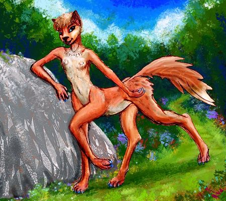
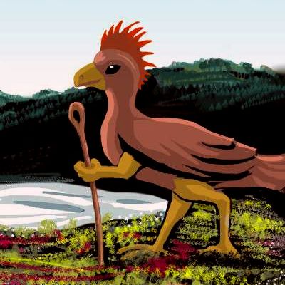
Foxtaur, stray glacial boulder, Arctica |
As I said, part of this is for consistency with Abyssia, but part's laziness. I have a hundred lovely dioramas featuring half a dozen sculptures of three six-limbed species--dogsized foxtaurs, deersize cattaurs, and equi, gracile horse-faced centaurs. I never used them to illustrate Abyssia because the land area was modest; they just weren't needed. Inversia, on the other hand, has nearly EIGHT TIMES as much land--2.2 times Earth's land area. Two or three worlds in one! That's why I've put it off so long; gonna be grueling.
So I'll need a LOT of Inversian illustrations--scenery, people, cultures--over the next few years. Waste not, want not...
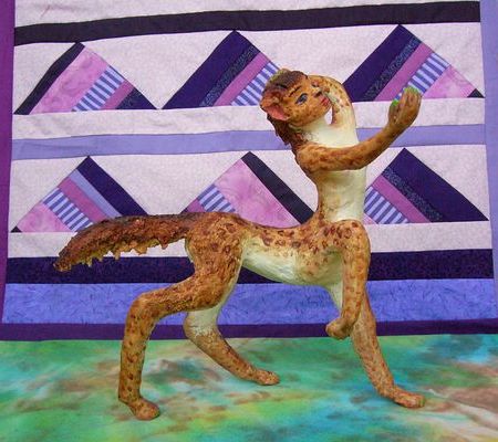
Leptaur; backdrop signifying the Mariana Mts. |
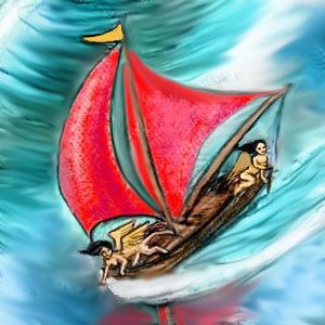
Large avian at sunset |
TOURING
In this tour, we'll circumnavigate Arctica. Why a boat, why sail round the pole? Well, the natives do; most of the fertile lands are coastal. But also... it's the only place on the planet you can. Sail around a landmass, I mean. Inversia's seas are powerful rain-generators, but they're small, just half the area of Earth's. Arctica's the only thing even resembling a continent in our sense--a big isolated chunk. Elsewhere the land's continuous, merely dotted by the modest oceans.
A few other basin-tours may be by air---ballooning, gliding and true flight in the dense air all are easier than on Earth. Most tours, though, will have to be by caravan... or railroad if the Inversians have built them. Have they? I'm still firming up the topography and climate! Can't lay rails over cartographic uncertainty--or ice. Both are bad trackbeds.
So I'm grateful for a nice safe sloop. Even if the climate's unearthly hot and the wind rather strong. Just speeds us along.
Intro - Biology - Norway (North Atlantis) - West Siberia - East Siberia - Beringia - Nunavut - Greenlake
We'll start our voyage east of Greenlake (which isn't green) and north of Icelake (not icy--how'd you guess?) on a scenic but modest fingerlake running east-west between craggy alpine fells. Cascades and falls. But dry summers--we're well inland. It's more Lake Windermere than some misty Norwegian fjord. Quite hot in summer on the north shore, where slopes face south. Black basaltic rocks soak up the sun. Pale dry grass. Streaks of pine down watercourses.
We sail east to to the lake's outlet, and down to the Kolbein River.
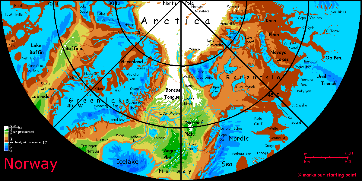
If we sailed up the Kolbein to Lake Jan Mayen, and on up the shallow braided silty Mohns River, we'd enter a deep slash between the Boreas Tongue, an icefield a bit like our Antarctic Peninsula, and the Molloy Range to the east, equally glaciated but much narrower--a single savage ridge. Mohns Canyon between them is one of the few places not actually on the icecap that feels Arctic in our sense--the lakes and river silty, freezing, roaring, the ground thawing just a month or two late in summer--stark and bare. Like Antarctica's dry valleys, it's not a friendly place for life. Bring plenty of food. You won't find any.
This narrow arctic desert is a close twin to the ice-free landbridge that opened up in our last Ice Age from Alaska down to Idaho, between the iced-over Rockies and the Coast Ranges. Looking at the barrens up the Mohns, I'm convinced humans came south in boats along New World coast instead, dining on oysters all the way. Trek inland? Insane!
But this long canyon doesn't lead to a New World--it's a road to nowhere, heading straight for the Pole, narrowing slowly until it dead-ends--buried in ice.
South down the Kolbein to Icelake. This idiotically named freshwater sea, which never ices over--thank you, Vikings!--is half again larger than any freshwater lake on Earth--about a third the size of our Caspian Sea. It's not just our Iceland, flooded, but twice as big--the glacial melt is copious and had no outlet till it filled the Icelandic basin close to an extra kilometer deep.
We sail east across Icelake, then southeast down the Faeroe River to Lake Faeroe.
Down through the Wyville and Thompson Lakes to the Aran Lakes and Lake Britain. Now just another thousand-plus kilometers south...
Down the short Dover River to the European Sea.
Northeast across the Netherbight into Danish Bay to the Kobenhavn Canal across the low point of hilly Skaggerak Isthmus, into...
...the Nordic Sea. Baltica on one coast, the Fjords on the other. Baltica is a bit geologically problematic--on Earth the Baltic Sea is the imprint of a massive icecap now melted. The land's slowly rebounding; in a few more millennia, it'd be a river plain (but since we're eager to melt Antarctica, this won't happen; sea levels will rise faster than the land does, expanding the sea until Scandinavia's an island.) Anyway, if ice created the Baltic Sea, what on Inversia caused Baltica to rise? H.G. Wells's Doctor Cavor, creator of "cavorite", that convenient substance opaque to gravity, would certainly have an explanation: antigravitic anti-ice! The rest of us may find it difficult to explain. Still, by my rules I have to postulate Baltica.
It's not a trivial matter. Baltica's bigger than Great Britain. Milder weather, too, barring the occasional stray hurricane. Dense, rich broadleaf forests--possibly farms (or orchards, if, as I suspect, our ocean-basin people are fliers in this dense air; why clear land when you can farm the treetops?) Densely settled, either way; one of the richest lands on Inversia.
Side trip! Upstream to Lofoten Valley and its dramatic crags above those deep, lushly forested lakes. Upriver to Lake Voring, surrounded by...
The alpine plateaus of Norway--Dumshaf ("doom's half") to the north, Aegir ("eye-gear") to the south and west.
Deep canyons--Voring Rift itself, heading northeast toward Lake Jan Mayen, and Aegir Canyon, leading back to Icelake. These are bigger than our Grand Canyon--nearly Martian! Not ice-carved, though of course ice-sculpted; these great cracks are spurs of the Atlantis Rift, that strange spreading zone--or is crust sucked under and recycled? Mysterious geologic processes. This IS Inversia!
Out through the ten thousand Finnish Isles, a lush and densely populated archipelago, temperate to subtropical. Round Cape Kola into...
Intro - Biology - Norway - West Siberia - East Siberia - Beringia - Nunavut - Greenlake
On east. Siberia is a complex land, but with a grand overall pattern, north to south:
East to west: the ice cap creeps farther south; the skirt of Siberia grows subtly narrower. The prairie is roughly even in width, due to those dry winds; it's the coastal forest that shrinks from Barentsia's quite Canadian sprawl to a narrower strip in Laptevia, Chukchi and Beringia, narrowing more along the Gulf of Alaska, until on the Beaufort Coast the ice-free strip is so narrow there are no trees at all, and very little grass.
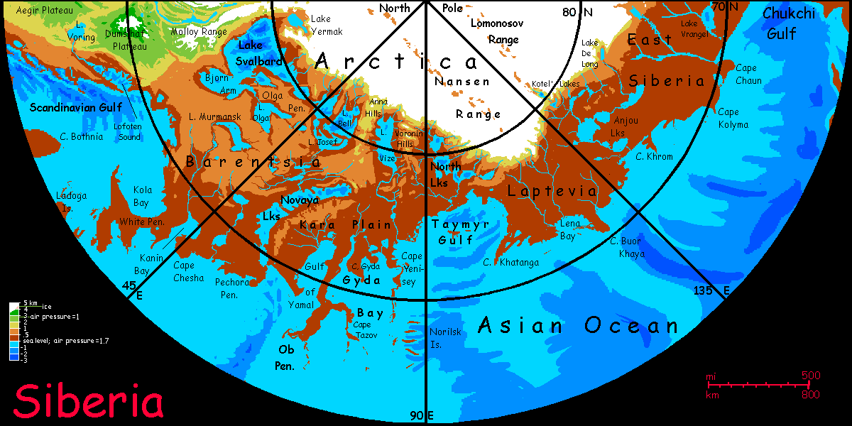
First the Barentsian coast--Kola Bay.
The White Peninsula. Warm and pleasant as Belgium or northern France... at 65° north!
Cape Chesha.
Pechora Peninsula. Again, French, or Oregonian if you like. Most winters, snow-free at sea level--and most of the land is low.
The Novaya Lakes. Shall we sail inland up to Lake Svalbard? No, it's a long, long side trip. But pause at least to explain their profound effect on the region. This line of gigantic icemelt lakes, considered together, are bigger than our Great Lakes, probably as big as our Caspian Sea! And in this warm dense air, never frozen. They mitigate the dry katabatic winds off the cap, making the great forests to the south possible.
Astute readers will notice that the various maps of Lake Svalbard don't match. The lake's certainly there and very big and roughly shaped as I've shown it--the heart of it's our Spitsbergen/Svalbard archipelago, inverted--but its outer arms are very shallow and I'm uncertain which way the lake would drain.
But the Ob Peninsula is beyond the reach of the ice--this narrow but VERY long cape winds far south into the Asian Ocean. Warm and green; indeed subtropical--occasional winter frost, but I doubt the Obbians get significant snow except in freak blizzards off the cap. Even Florida freezes after all--now and then. Occasional hurricanes in summer.
Cape Tazov and the islands. Gyda Bay. Cape Yenisey. Again, muggy and warm most of the year--Taiwan or Carolina, not Siberia. Again, summer storms we'd see as severe. Still, nothing like the frequency and intensity of storms at lower latitudes in these deep basins.
The rugged Norilsk Islands--not tropical, but quite mild, especially on the sunny south shore--the islands all run east-west. Great cliffs--very scenic. If the isles exist at all. In our world, the Norilsk Lakes are almost certainly inland fjords scoured out by glaciers descending from the hills to the east, in the Ice Age. For Inversia I "simply" invert all landforms; and often the result looks geologically plausible--until you ponder causes. What raised the equivalent ridges on Inversia? Anti-glaciers? Are these more or less scientific than a Siberian Maui with a bone fish-hook, a tectonic catfish speaking Japanese, or sloppy Yurok dancers who carelessly failed to balance the world? Odd how a simple minus sign can create a landscape that look eerily plausible in some places, nonsensical in others.
Well, as long as we don't look at their geological roots, the Norilsk Islands are dramatic--lovely scenery. Plus, those great cliffs shelter their south coasts from the Arctic winds. They're even milder than the rest of this suprisingly mild region--little subtropical oases.
Intro - Biology - Norway - West Siberia - East Siberia - Beringia - Nunavut - Greenlake
To the east, we're entering harsher, more arctic lands. From the Norilsk Islands it's a full thousand miles due north to the head of Taymyr Gulf. And it feels north. The first treeless shore you've seen. Too close to the ice here for forest! And the line of great lakes at the foot of the great ice has shrunk too, so the winds are drier here in the Wild East. The North Lakes are as big as our Great Lakes, but they're still puddles next to Lake Svalbard. Not enough to rehumidify the dry katabatic winds screaming off the ice. Chill, windy prairies, freezing hard and long in winter. As cold as... Chicago! Still, the grass is rich, the subsoil unfrozen. This isn't tundra or arctic barrens.
The loneliness of Turfan and Baikal |
Into Laptevia, a broad plain like Barentsia. As the skirt around the cap widens, the coast greens. Forest again--though a narrower belt than back in the west, with wide cool prairies inland.
South around Cape Khatanga. No lakes inland--just lots of un-tundra. But the Cape itself, well out in the mild Asian Ocean, is green and fertile, and beyond it, to the east, the coastal strip has low forest for hundreds of kilometers inland.
Fertile Lena Bay... Almost a little inland sea. Islands shelter the bay waters. A mild pleasant climate; broadleaf forests and meadows, though evergreens dominate not far inland. Northern France or Belgium, maybe?
From Lena Bay, geography demands we detour--conceptually, at least. The curving Lena Ridge leads south into the heart of the Asian Ocean, largest on Inversia. No land for a couple of thousand kilometers, but the ridge is shallow enough so coral has slowly built up rich fishing banks; your boat is not alone. In places the coral's built up shallow enough to snag a hull; a local pilot is advisable. This long ridge is the very end of the Atlantis Rift/Ridge system; it may someday rise enough to build a long green cape much like Ob or Baltica. Even after the shoals recede into deeper blue, if you sail another few days southwest you'll find proof this rift is active. You'll reach...
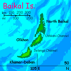
The Baikal Islands--three long, rugged, forested ridges rising sharply from deep water up to extensive plateaus 500-1200 meters high (1600-4000'). They run a good 640 km (400 mi), with just narrow channels between them. The heights see winter snow, but the coasts are subtropical (yes, at 51-56° north); the northwest slopes and coasts are wet, the southeast sunnier and drier. Baikal's a pleasant if isolated place to live. Will Inversian civilization, so intensely land-based, have even discovered the chain? It's nearly the most isolated land in the world. Still, the Lena Banks will lure fishers most of the way... consider how the Basques fished all the way to the Grand Banks on the edge of the New World (though never divulging their secret).
On the other hand, the record-holder, THE loneliest land on Inversia, lies another 1300 km (800 mi) to the west-southwest, with no such chain of rich banks to lure fishing boats on into the ocean's heart...
Turfan, a low green island just 160 km long and just 40 wide (100 by 25 mi). Baikal's the nearest land; it's over 1600 km (1000 mi) west to the next nearest, the modest Aral Islands. Either the loneliest land in the world, OR the busiest--like Hawaii, Turfan may be a busy port precisely because there are no alternatives--the only place to rest, refuel and restock on the long voyage across the Asian Ocean. Though Turfan's small, the muggy climate and copious rains guarantee it'll have fresh water, fruit and greens year-round.
My guess: all these islands will be well-known because these dense-aired lowlands make flight so easy. I'm betting the people here, whatever their lineage, are winged; someone, sometime, got blown off course in a storm and stranded. And winged castaways aren't trapped, once the storms end; odds are they'll make it back to tell of their salvation and discoveries.
Let's get back to mainland Arctica. Where were we? Oh, Lena Bay. Just east of this is Cape Buor Khaya, another cool-temperate peninsula as big and fertile as Denmark.
North and east of Buor Khaya are the Anjou Lakes, as large as our Great Lakes--that is, large enough to mitigate the dry polar winds somewhat. Also, the ice retreats a little around the Kotel' Valley and lesser canyons to the east of it. So while there's a broad skirt of barrens and cold prairie down to the north shore of the lakes, forests rise on the southern shore, and extend, growing taller, denser and more diverse, all the way to the sea. This strip is just a few hundred km wide but thousands long--all the way from Cape Khatanga to Bering Isthmus itself.
Cape Kolyma ("Pass me that cola, Ma") and Cape Chaun (rhymes with "down"). Together these form another Denmark-size peninsula of forest much richer than the thin taiga woods on the mainland to the north.
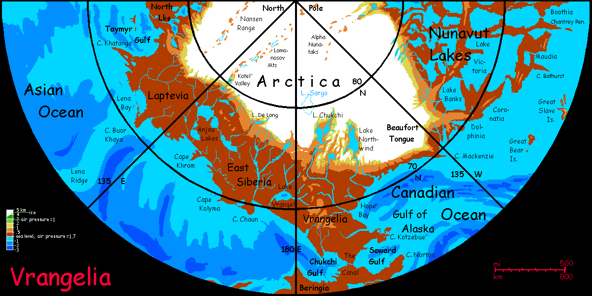
Intro - Biology - Norway - West Siberia - East Siberia - Vrangelia and Beringia - Nunavut - Greenlake
Vrangelia: in the west the wooded strip is narrow, but Lake Vrangel is close to the coast; out of all the arctic lakes we've passed, it's the only one to be wooded (if thinly) on the north shore too. Beyond the lake, the coast angles south toward Bering Isthmus and the Diomedes Canal. The woods quickly grow warmer; still mostly evergreen around the Canal, but with more broadleaf trees than we've seen since Cape Ob. Cool-temperate country, not subarctic. It's not just our southerly detour (all the way down to 65° north, not the 70 we've danced around for weeks); the land is sheltered by the Chukchi Hills to the north.
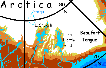
Also, the polar cap retreats here. There's a huge gap--the Northwind Lakes. This wide, mostly ice-free valley is nearly as big a bight in the cap as Antarctica's Ross Sea. Why such a big icefree area? Same reason as Ross--the land's just too low for ice to build up. In the Ross Sea it's because a tongue of sea intrudes. On Inversia, too, but a different sea: of dense warm air. Down in Inversia's deep seabasins, lowlands at even 75 or 80 north are too warm for ice to build up. So Lake Chukchi and Lake Northwind, though flanked by ice on three sides, are fairly stable--iced over most of the year, but thawing a month or two. The shores are arctic barrens; low, sparse vegetation. With cold air pouring off those icy highlands all round, and mountains shading much of the valley from the low-angled arctic sun, the ground warms late; the growing season's just too short for much.
Northwind is unusual. Other great rifts cut into or even right across the ice cap, but are ice-choked. Indeed, northwest of Lake Chukchi, and part of the same complex, is a smooth ice-plateau hiding a third deep basin, Lake Sargo; ice over two miles deep has sealed off this lake for millions of years. To the north, also ice-buried, is the Mendeleyev Valley, nearly crossing the icecap, but totally filled. What keeps the Northwind Basin ice-free is that it's open to the warm southlands; meltwater easily drains and the lakes stay low. This pattern is seen all round the Arctic cap: Mohns Canyon and the Yermak Basin are ice-free, but only the very ends of the Kotel' and Alpha Valleys are--most of the lakes in these long, quite deep rifts are ice-dammed, so their surfaces stay too high to ever thaw. As snow piles up, the air at the surface thins and cools to Earth-normal for the pole... I'm sure there are bacteria living down down in the freezing dark, as in Antarctica's Lake Vostok, but nothing bigger. Drainage matters. "Dammed is doomed."
Let's get back to living lands!
The Diomedes Canal, about 80 km (50 mi) long--about 35 km of canal (20 mi) up to the Diomedes Lakes, then a cut through the Bering Hills and down the Fairway River to Seward Bay. The Diomedes rivals the Panama and Suez Straits as the busiest shipping channel in the world. It's inevitable. For ALL shipping between Old World and New, no alternative route exists. 20 km or so (say 12 mi) in the eastern stretch involved several cuts of up to 50 meters (say 160'), but the effort was worth it--the canal's at sea level--no locks at all.
Yes, it took a lot of digging, but at least it wasn't in sweltering, fever-ridden jungle, like our Panama Canal. And the workers didn't live in squalid muddy camps. This is the Basin and the workers could fly--commuting from the seashore, from pleasant subtropical beach towns. A sea-level alternative was possible, snaking north around the Bering Hills, reducing cuts to a mere 10-20 meters (33-66'), but skirting them meant doubling the length; a poor trade-off.
South of the Diomedes Canal is Beringia. The northern half is a wide, low plain of orchards and croplands. The south humps into the Bering Plateau, mostly 2-3 km high (7-10,000'). Dark-forested flanks, then alpine meadows, broken by deep canyons--Shirshov in the northwest, curving, lake-dotted Bowers in the middle, and Aleut Valley, largest of all, in a huge arc to the south. Beyond lies the rugged, gigantic Aleutian Range, 6 to 7.5 km high (20-25,000'). South of it is the high valley of the silty, braided Aleut River, and then the icy North Pacific Plateau, some 6 km high (nearly 20,000')--climatically just half that, but at this latitude that means much of it has iced over and all of it is barren.
So the Canal mimics, in miniature, what Beringia as a whole is: a strait or bridge of warmth, dense air, rain, and life itself, between Arctica and North Pacifica--two lands in cold storage.
Intro - Biology - Norway - West Siberia - East Siberia - Beringia - Nunavut - Greenlake
We emerge from the Diomedes Canal into the Alaskan Sea, the northwest arm of the Canadian Ocean. Out of Seward Bay, north past Cape Kotzebue and Selawik Island--wooded country still, if not as rich as Beringia. Narrow spruce. Up into Hope Bay--the trees slowly dwarfing as we near the cap. Past 70 north in Barrow Bight--and the trees fail. Inland, over the cold hissing prairie, the pale gleam of ice on the horizon--well, floating above it in the haze. Here the Beaufort Tongue reaches south almost to the sea, a mere 200 km (125 mi) inland. The reason's simple; the underlying Beaufort Plateau, a good 3 km high. The floating gleam you see really is floating; not an Ice Age glacial dome at sea level, but an alpine icefield that just happens to be continental in size--because its platform is.
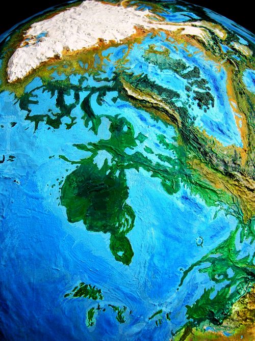
Days east along this stark Beaufort Coast. Then, at Cape Mackenzie, things start improving: the plateau and thus the ice both retreat sharply north, and the land breaks into a great maze of wood and water: Nunavut.
Dolphinia's long central swell is over a kilometer high (about 4000'). Pinewoods to the north, broadleaf forest to the south. This mild strip, tilted toward the sun, is cool-temperate; winter snows on the south shore are brief.
Coronatia. More so. Twin ridges, three parallel lake-dotted valleys, all as warm as southern Dolphinia. The Bathurst Peninsula, especially around sheltered Banks Bay, is snowfree some winters. You can't grow oranges, but...
Maudia, lake-dotted. The mild Chantrey Peninsula and Franklin Island. All these lands have piny Swedens attached, running north hundreds of km...
Ahead is Boothia, largest and warmest of all (at its south end at least.)
Each of these is a Denmark (or two) with a freshwater sea on the north side, salt sea on the south. Denmarks with climates more like Portugal or Corsica.
But we don't reach Cape Boothia; instead we have to head north into Boothia Gulf and up into Lake Somerset. We're circumnavigating Arctica; trust me, we have to. Going on around the shores of the vast Canadian Ocean is another tour [don't click yet!]
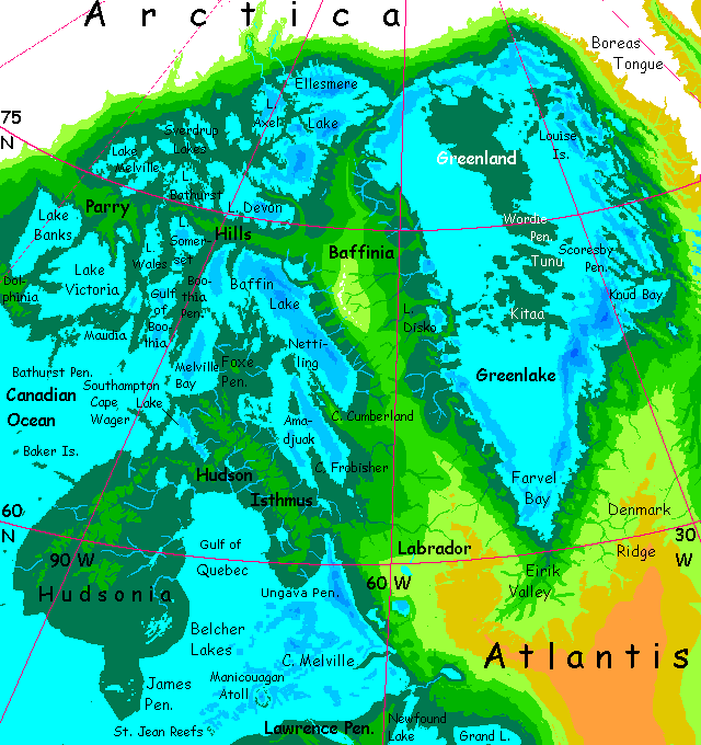
But to circumnavigate Arctica, we must head northeast, up Lake Somerset to the mouth of the Parry River; a great flow, wide and deep, for it drains a gigantic basin. No rapids even where it cuts through the Parry Hills in a canyon with palisades higher than our Hudson. Your ship slows against the current but the dense air means even a mild sea-breeze has enough horsepower to overpower the 'Big Milky'. It's obvious why the Parry's called that: opaque, turquoise and chalky. Loaded with glacial silt.
I don't know yet what species the locals are, but I am confident they have splendid teeth.
Into Lake Bathurst. Veer northeast. If we stayed due north or turned northwest, we'd be detouring into the Sverdrup Lake country... back into chilly, windy untundra. The icecap here still sprawls south of its average latitude, though the plateau is retreating steadily to the northeast. And there's a break: a lake-filled crack in the cap like Northwind, but smaller: the Alpha Valley. A chain of lakes reaches far inland, but only the edgemost is ice-free; the rest are smothered, the valley a mere miles-wide groove in the cap. Anyway, it's all cold Canadian country, the least settled part of Nunavut.
Northeast through Lake Bathurst. Spruce-forested shores still, though we're past 75° north now, well beyond the treeline anywhere on Earth. The air's so dense even an icecap three times the size of Greenland can't sour the climate here, not entirely. And the icecap is retreating as we sail east, pushed back by the great tongue of lowland around Greenlake, our goal.
East through the north arm of Lake Devon.
Northeast through long Lake Ellesmere, a huge triangular lake the size of England, very deep, over 2 km in places, with a rugged floor of long ridges, only one of which breaks the surface--long narrow Hazen Island in the northeast. Hazen, some 75 by 25 km (45x15 mi), is about the northernmost island in the world. Windy barrens on the northern shore exposed to Arctic blasts, grassland on the south shore sheltered by the central ridge... but even here, not true tundra. No permafrost. Only a few villages, all on the south shore, subsisting more on fish and herding than farming, but they have gardens, even fruit trees in the sunniest, wind-sheltered corners.
At this latitude on Earth, all land is frozen.
Through the short Kennedy River--ice floes in some bad winters, but never freezing over--into...
Intro - Biology - Norway - West Siberia - East Siberia - Beringia - Nunavut - Greenlake
This freshwater sea is more than half as big as our Mediterranean. In the north, its shores are cold grasslands; in the middle, taiga and evergreen forest; in the south, hardwood forests and meadows, and a climate perhaps comparable to France.
Greenlake has, running down its middle, an archipelago larger than the British Isles, which we can only call Greenland. This rise is, of course, in our world a depression; but a hidden one. The Greenland icecap's great weight has bowed the great island into a bowl, with a mountainous rim and a center well below sea level. On Inversia, with the region ice-free, this geologically inexplicable rise is exposed; a great whaleback stretching 2000 kilometers. Greenland! In the middle of Greenlake.
Which isn't strictly green, but it is a peculiar color. It's a milky turquoise, to be exact--a whole freshwater sea full of glacial silt so fine it's permanently suspended.
The shortest route to our starting point is around Greenland to the north, into Scoresby Sound, and upriver to the fingerlake where we began 16,000 km ago (10,000 miles. TIme flies!) But there's an isthmus blocking our way. It links Greenland to Arctica to the north. In our world, its equivalent, a deep canyon, was only recently discovered under the ice. The last time the great bowl of Greenland thawed a bit, the pent-up water in the interior broke through here to reach the sea, carving a chasm like some branch of the Mariner complex on Mars. On Inversia, this canyon, inverted, is a sinuous winding ridge, narrow, cliff-flanked, in places in rearing 100 meters above the lake like a sea-serpent, in others barely above water.
If this seems bizarre and you think I should omit this inverted scar of an... antiflood?... please consider Adam's Bridge, connecting (in my time; once connecting, if you're you're reading this after my death) India and Sri Lanka. This winding roadway through the ocean is a fine example of an inverted floodchannel, and strong evidence that Earth is some eccentric planetary artist's caprice. The world turned inside out! Go on, explain Adam's Bridge rationally. No, ignore Mr Slartibartfast and Doctor Cavor. They're not catcalling. They're not there.
Anyway, we can't just sail north around Greenland--that inexplicable isthmus, which we'll have to call Erik's Neck, is in the way, because I'm sticking to our Inverted principles. It's there because it's there. Up to you lot to explain it. So our boat must veer starboard; it's down Greenland's southwest coast for us. Several days, from cool grasslands--not tundra, just windy--the prevailings are off the icecap to the north and Boreas Tongue to the east. As we sail south, the rising central hills of Greenland start to shelter us from those desiccating winds, and low, scattered spruce appear. Within a day, tall evergreens dominate.
The southern half of Inversia's Greenland is honestly named. But don't grieve over the loss of that huge climatological lie writ so large and splendid on our maps! (The Vikings did bad, but they always did big.) Inversia still has nomenclatural irony with Viking roots--this time an honest name that's become a lie. Remember Icelake, that great lake to the southeast that never ices over.
Through the Wordie Strait, with Tunu to the south, a new Ireland... well, less boggy. Big mountains and icefields to the east, upwind; even huge Greenlake isn't enough surface water to generate Irish rains or verdancy. Or mold. Still, Tunu will be rainy--solidly wooded away from the northeast shore facing the blizzards off the ice.
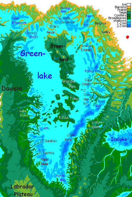
If Tunu's people were human, the island would be a quilt of fields, forests and farms, but I suspect the sea-basin people are fliers, so Tunu's a hundred-mile strip of flowering orchards.
A whole arc of similar islands, each a bit more blizzard-sheltered, a bit warmer, greener--stretches southwest. Kitaa is even bigger than Tunu, and even more fertile.
But we're circumnavigating Arctica, so instead of wandering that pleasant archipelago to the southwest, we must tack right into that cold dry wind, northeast into Scoresby Sound--broad lobed bays between jagged winding ridges with huge, raw seacliffs up to a kilometer high--the inversions of our fjords.
I certainly am glad I'm not the one who has to explain their geological origin.
Off to port, this ragged, rugged coast is quite arid--brown grasslands and even barrens. In the lee of Boreas Tongue, katabatic winds sweep off the icefields--very close here. The huge drop warms them--compression--so the coast isn't tundra, but those winds are bone-dry. A cool desert if not a high-arctic one, reminiscent of the drier bits of Patagonia or Labrador. And just as rugged.
Here in Scoresby we're south of the Tongue, though. It's why we're heading up the largest river. This stretch is the lowest route across Norway, indeed across all Atlantis. Here the winds sweep in from the Eurasian Ocean over passes barely a kilometer high. Rough uplands, with rocky, dry-grass slopes, certainly the dry side of the mountains; but the heights are pine-forested and the riverbottoms green.
Up the Scoresby River, till we can sail no more.
The final leg, you have to hike. A few days up the shrinking stream, steadily climbing. It's warm, even hot, though the pass is 12-1500 meters up (4-5000'). Basalt boulders, wildflowers, dry grass and wind.
You look down into summer haze, where, a day's hike below you, lies a certain long fingerlake, on a tributary of the Mohns River...
Full circle! And about the only part of Inversia where a voyage of circumnavigation is even possible. This was easy.
Elsewhere... our tours will get difficult.

CLICK A REGION for local maps & illustrated tours. Many areas still lack tours, though. These are done:
Arctica -
Canadian Ocean -
Amazon Ocean -
Medimarea -
African Islands -
More worlds: see Planetocopia
World Dream Bank homepage - Art gallery - New stuff - Introductory sampler, best dreams, best art - On dreamwork - Books
Indexes: Subject - Author - Date - Names - Places - Art media/styles
Titles: A - B - C - D - E - F - G - H - IJ - KL - M - NO - PQ - R - Sa-Sk - Sl-Sz - T - UV - WXYZ
Email: wdreamb@yahoo.com - Catalog of art, books, CDs - Behind the Curtain: FAQs, bio, site map - Kindred sites