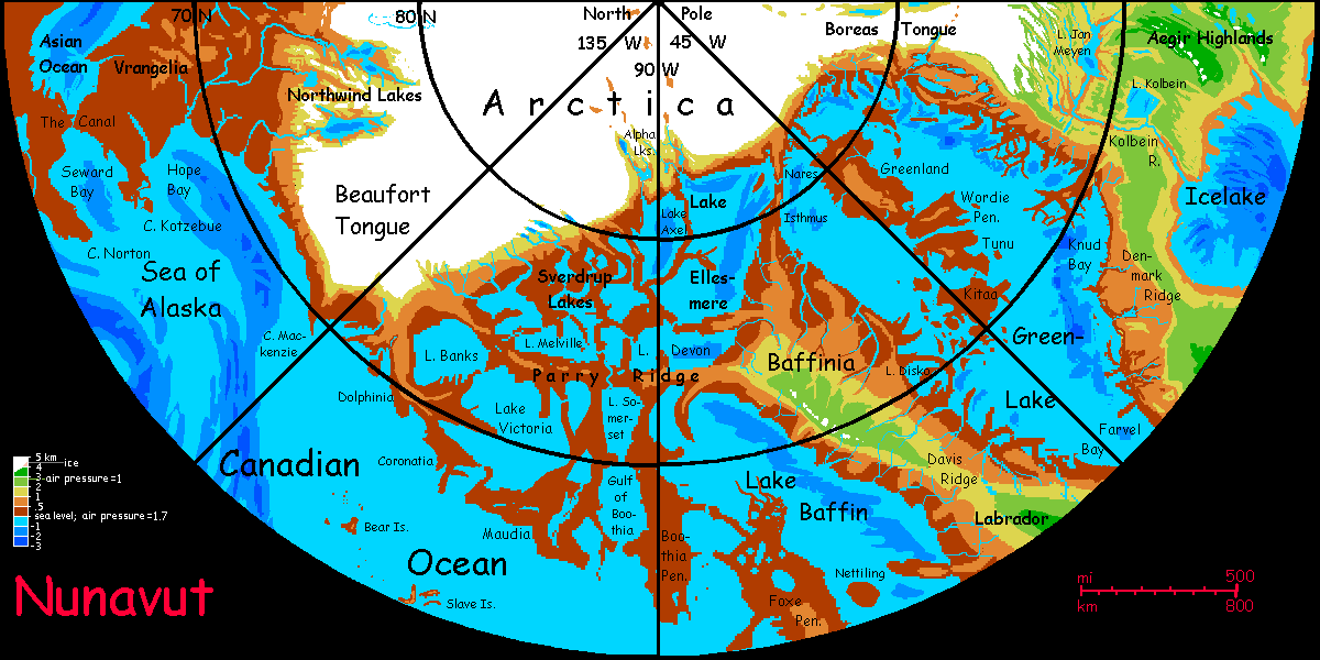
The Canadian Ocean
by Wayan, 2006-2025 (yes, I really started this 18 years ago)
for Anahareo, Jack London & Farley Mowat, chroniclers of the North
more planets: Planetocopia -
(under construction--don't click yet) Inversian geography and climate - Evolution on Inversia - Creatures and peoples - Regional tours - Gazetteer -
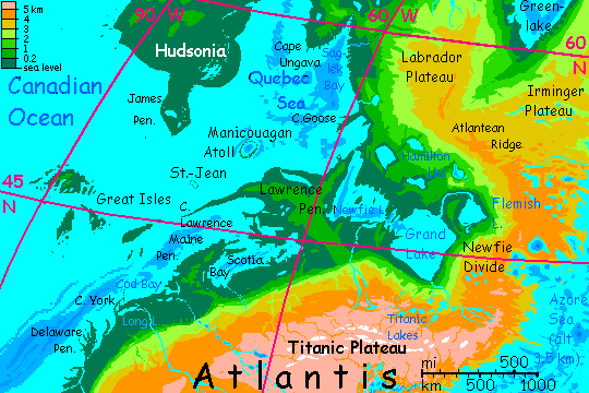
Introduction - North - Hudsonia - Great Is. - Craters - East - Mexico - South - West - Cascadia - Beringia
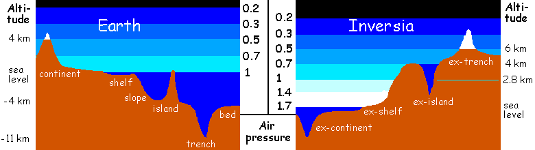
This basin has the world's third largest ocean. A strait miles wide links it to the Amazon Ocean to the south, and a low isthmus with a canal links it to the Asian Ocean to the west; these spillways or sills ensure the basin's sea level is the same as the others. Air pressure is thus the same too, nearly 1.7 atmospheres. That density traps heat. Other basins get very hot--muggier than our dinosaur eras--but much of the Canadian Basin is high-latitude, and thus temperate to merely Earth-tropical, and actually pleasant to visit. Unlike, say, the African Ocean, many Canadian shores have wide, low coastal plains, so we'll encounter several million square km of this anomalously Earthlike lowland.
Who lives here? Well, the locals aren't humanoid. Basin life tends to glide or fly; with air this dense, maximum flight weight is at least 25 kg (55 lbs). So the majority of locals will be huge ravens and parrots, gliderwolves and lebbirds. What's exotic here in Canada is how many are wingless like humans; the non-muggy climate welcomes Atlantean and Pacifican highlanders, cold-adapted and flightless in their native thin air. Not that they're human either; the basic body plan on the high plateaus is centauroid.
Introduction - North - Hudsonia - Great Is. - Craters - East - Mexico - South - West - Cascadia - Beringia
We'll enter the Canadian Basin in its far northwest corner, via The Diomedes Canal, about 80 km (50 mi) long--about 35 km of canal (20 mi) up to the Diomedes Lakes, then a cut through the Bering Hills and down the Fairway River to Seward Bay. The Diomedes rivals the Panama and Suez Straits as the busiest shipping channel in the world. It's inevitable. For ALL shipping between Old World and New, no alternative route exists. 20 km or so (say 12 mi) in the eastern stretch involved several cuts of up to 50 meters (say 160'), but the effort was worth it--the canal's at sea level--no locks at all.
Yes, it took a lot of digging, but at least it wasn't in sweltering, fever-ridden jungle, like our Panama Canal. And the workers didn't live in squalid muddy camps. This is the Basin and the workers could fly--commuting from the seashore, from pleasant subtropical beach towns. A sea-level alternative was possible, snaking north around the Bering Hills, reducing cuts to a mere 10-20 meters (33-66'), but skirting them meant doubling the length; a poor trade-off.
The Gulf of Alaska has a ragged shoreline, but there are no deepwater islands at all (since Central Alaska has no deep lakes). This pattern continues throughout the northern Canadian Ocean; complex coastline, shallow water, low coastal islands, but very few far offshore. Baker, off Cape Chesterfield, is some 300 km out from the mainland. But in the main this is a simple, unbroken sea, unlike the maze of lakes and islands to the north and east. The only deepwater islands are the Great Bears and the Slaves.
The Great Bear Islands
Largest by far is McTavish, about 60 km across, with hills rising about 300 m (1000'). Some 160 km (100 mi) to the west is low, triangular Keith, only 10-15 km across (5-10 mi). Both are densely forested, mostly with pine, aspen and maple; this could be Maine, or Seattle. The tiny Eska Islands, surrounded by extensive reefs of coral and kelp forest, stretch north and west several hundred km.
Yes, coral. Cold, slow-growing coral; but the climate is temperate despite the high latitude (65-66°N). Snow falls many winters, but this sea never freezes. Not even close! Why? The air down in this basin is very dense, about 1.7 atmospheres; that thick blanket keeps the coasts a good 10°C warmer than Earth at these latitudes (18°F!).
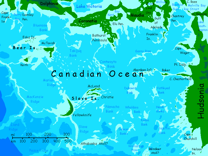
500 km (300 mi) to the south-southeast of the Bears are the Slave Islands. McLeod and Christie in the east are twins--each a narrow, curving ridge, densely wooded, some 50 km long, 10 wide and several hundred meters high (30 by 6 mi, up to 1000' high). To the west is Yellowknife, a third rugged island, probably the largest and certainly the tallest (450 m, 1500'). I have sharply contradictory data on the shape of Yellowknife so far. It's a small island, it's a big J shape, it's not there at all, it's a tall crag... I've shown its largest likely footprint--a fishook up to 100 km long. Dense forests, mild-temperate or cool-subtropical. Portland, or San Francisco?
All I'm really sure of is that coral reefs will surround the main island and stretch 200 km to the west, just as with the Great Bear rise.
A line of shallows lead south-southeast another few hundred km to one probable reef and just possibly an atoll: the Athabasca Reefs, the equivalent of our east end of Lake Athabasca. My sources are inconclusive. I'm sure coral will build up to the surface; just don't know if erosion will keep it mere reefs and bars, or if some will be sheltered enough for plants to anchor the sand. If they do, it's rainy and warm enough here for palm trees to flourish. An almost Polynesian islet--at the latitude of Sitka! That's what dense air will do, quite without high carbon dioxide levels.
Similar atoll-arguments could be made for many lesser lakes on our Canadian Shield, especially Reindeer Lake. As rises in the Canadian Ocean, few would reach the surface, but many would be shallow enough to support coral growth, so low islets are possible, even probable--but where? I don't know. I tried to find out, lake by lake, but even the big lakes in northern Canada are barely mapped yet--bathymetrically, not at all.
Southern Canada's denser settlement means the mapping's better, though the news isn't. Three big Canadian lakes, Lake Winnipeg in Saskatchewan and Lake of the Woods and Lake Nipigon in Ontario, are just too shallow to become more than sea-floor rises on Inversia.
Introduction - North - Hudsonia - Great Is. - Craters - East - Mexico - South - West - Cascadia - Beringia
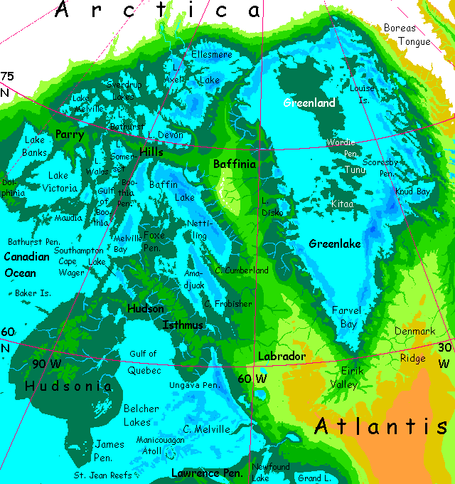
This huge complex peninsula is a subtropical to mild-temperate lowland forest, despite its high latitude. Most winters, only the northern hills near Foxe Isthmus see much snow. Ironic, since our Hudson Bay was of course created by the great weight of ice on it. Inversian geologists will have to concoct their own explanation for their great Hudsonian bulge in the Canadian Abyssal Shield. Don't wait up for a Dr. Cavor to evolve and propound her theory of Antigravitic Non-Ice. Geographically convenient, and of course correct--but I doubt Inversian physicists will buy it.
Hudsonia, the Hudson Isthmus and the Foxe and Ungava Peninsulas are all prime farmland, if Inversian lowlanders farm, and I suspect they will. But since lowlanders can fly, they won't bother clearing the primal forest, just selectively log when they need wood and replant with improved fruit and nut trees. Net result: an orchard twice the size of Texas!
It's the largest stretch of fertile lowland by far. Arctica's ice and its dry cold winds tend to dry the shores of Greenlake and the northeast Canadian lakes--pinewood and prairie, with orchards only in wind-sheltered coves. But the mountains of Baffinia and Labrador block those winds. Hudson Wood will be the heartland of the Canadian Basin--its population center and avocadobasket (no one eats bread; fliers prefer nuts and oilfruit--more concentrated calories, and more flavorful than bland old starch).
I won't spend any time on the highlands of Baffinia or Labrador; these two great featureless domes rise into thinner, colder air that gives them climates almost identical to Earth's at these high latitudes, 60-75°. Think Canada's north woods, or Alaska without the dramatic scenery. Sparsely settled, for good reason; there can't be over a million thinly scattered residents, mostly wingless Atlanteans with a cranky need for solitude. Lowlanders could live here, even fly on most of these slopes with effort, but it's just too cold and dreary for them.
Introduction - North - Hudsonia - The Great Islands - Craters - East - Mexico - South - West - Cascadia - Beringia
The Great Islands are of course the inversion of our Great Lakes. But since the lakes are at various levels and have very different depths, the resulting Inversian islands are... unexpected. We'll go down the lake-chain from headwaters to the sea, though on Inversia this is meaningless of course; they all rise (or don't, in Erie's case) from the seafloor as equals.
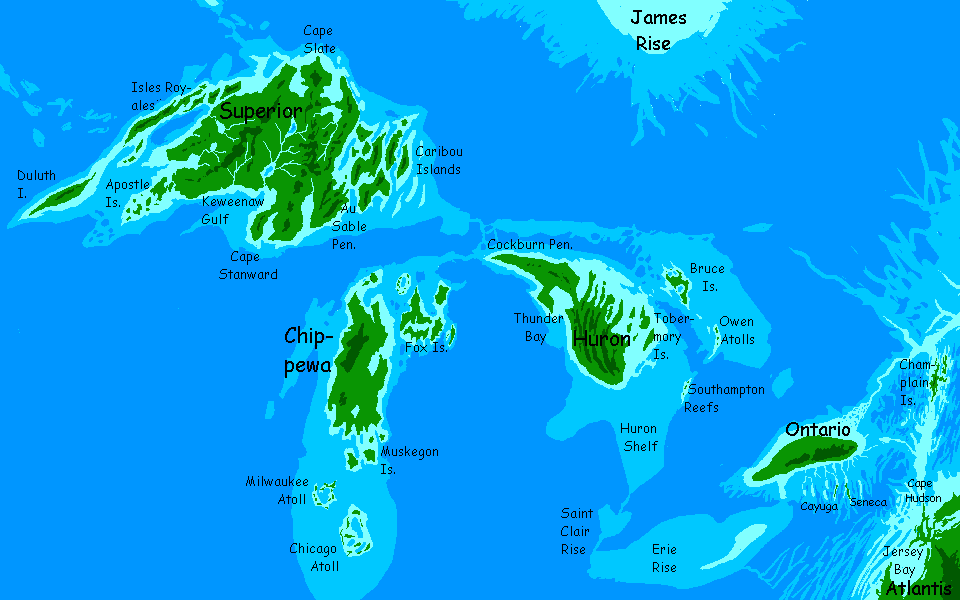
THE SUPERIOR ISLANDS
Superior, the central island, is by far the largest--bigger than Massachusetts, Connecticut and Rhode Island combined. It's still less than half of our Lake Superior's bed. Superior's glacier-gouged bed is the deepest of the Great Lakes, but it's also the highest of our lakes, limiting how much dips bleow sealevel. A halo of lesser islands surround it.
There's a small but quite deep lake near the center of Superior, Inversia's equivalent of our Superior Shoal; logically we must call it Lake Superior, all ten gallons of it. It really is upstream, which is all Lac Superieure meant; nothing to do with size or quality (yes, the islanders claim to be superior in other senses, but that's just snobbery). The Superior River is by far the longest on the island, so I guess it has a faint claim to be smug--a smug little creek by continental standards. It runs south into Lake Manitou, then to Keweenaw Gulf.
There's still an Isle Royale off Superior's northwest shore--a chain in fact, the Isles Royales, where in our world the Great Ice scoured out a deep channel. These Isles Royales have wolves on them. But in this snowfree country they won't be our shaggy arctic wolves. They'll be rangy, shorthaired critters--big coyotes. Except... I suspect they'll have skin flaps letting them glide better than flying squirrels. After all, down in these deep basins, the air's dense and oxygen-rich; very big animals can fly. If deer and rabbits can, the wolves will have to, to hunt them. Climb a tree, launch, and with luck, launch turns to lunch.
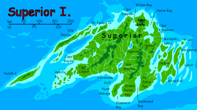
But if flying becomes the wolfish way to get around, that frees up the forepaws a bit to become more handlike. Useful for tree-grasping too. They might just do it. And this isn't our Arctic; far warmer and greener. These wolves, like our coyotes and dogs, will only nominally be carnivores. In practice they're omnivores, in a land much richer in plant foods than our North. Bad hunt? Go harvest fruit and nuts. Once you can fly, treetops become safely harvestable. No more falling out of trees--a real hazard for even creatures we see as confidently arboreal like the (other) great apes. Lifespan lengthens; culture strengthens...
Still the most likely candidate for intelligence in the archipelago (and all over Arctica) will instead be a creature already well adapted for flight: the giant raven. By giant, I mean a four-meter wingspan, a century-plus lifespan, a gravelly but fluent speaking voice and a hundred-gram brain to back it up. Since our little ravens are at least as smart as chimps already, I'd bet on the ravens over the wolves. Though they might co-evolve, extending the symbiosis seen in some parts of our world, in which ravens guide wolf packs to prey in exchange for a share of the catch. Cross-species communication fosters languistic and cognitive skills better than merely having to understand your own species.
Humans are pretty narrow-minded and deaf to others, really. Your dog understands quite a lot of human language. How much dog do you understand?
MICHIGAN ISLANDS
The equivalent of the northern half of our Lake Michigan is a large island, Chippewa. South of this are only the small Muskegon Islands and scattered coral atolls like Milwaukee and Chicago. Sadly, our Green Bay is just too shallow to become land on Inversia. The narrow, twisting Fox and Traverse Islands lie to the northeast. Rich forest and farms. Maybe not coconuts and bananas, but citrus and avocado would thrive.
Ah, the orchards! With megaravens and gliderwolves as the farmers. They don't even need ladders to pick the fruit. Green Acres are the place to be...
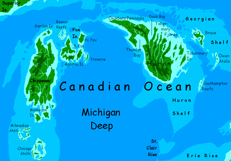
HURON ISLANDS
Huron is quite a large island near the center of our Lake Huron's bed, fraying on the northeast side into capes and bays and finger islands, the Tobermorys. To the south is only Southampton Reef. Our world's Saginaw Bay and North Channel are just too shallow to create land on Inversia; though some coral reefs do create shallows. To the east, Georgian Bay, the all-Canadian part of our lake, creates only slender little Bruce Island, and further southeast, Owen Reef. All in all, more land than the Michigan Group, but both together don't equal Superior.
ERIE ISLANDS
Sorry, there aren't any. Yes, Lake Erie's big, bigger than Ontario, but it's shallow; not a bit of its bed dips below sea level--not even close. So on Inversia, not a rock.
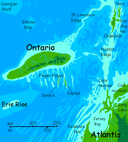
ONTARIO ISLANDS
On Earth, Ontario may be the smallest Great Lake, but Inversia's Ontario Island is fully 250 km long and over 50 wide, quite as big as the Huron or Michigan groups. Logical if you think about it--it's our only Great Lake below Niagara Falls; since it's near sea level, much of its bed dips below, to become dry land on Inversia. Well, not dry; it's a warm, rainy island more Caribbean than Borsht Belt.
To the east is Champlain, a winding north-south island some 80 km long though never much over ten wide. Off its northeast shore is a lesser parallel ridge: the Hero Islands.
South of Ontario are Seneca and Cayuga, two narrow isles each about 50 km long--in our world, the southern, deeper halves of the two largest Finger Lakes. Startling cliffwalled islands, where waterfalls drop from the jungle into the sea.
Ah, the tropical paradise of upstate New York...
Another dozen sinuous Finger Ridges rise from stretches of sea floor hundreds of meters down, wandering the submarine hills like lost bits of the Great Wall of China. Coral-encrusted, but slow-growing in the dim light; few are high enough for rich coral reefs like those off northern Seneca and Cayuga. Their origin is mysterious.
"Non-ice ungouged them"? Yes, thank you, Dr. Cavor.
Introduction - North - Hudsonia - Great Is. - Craters - East - Mexico - South - West - Cascadia - Beringia
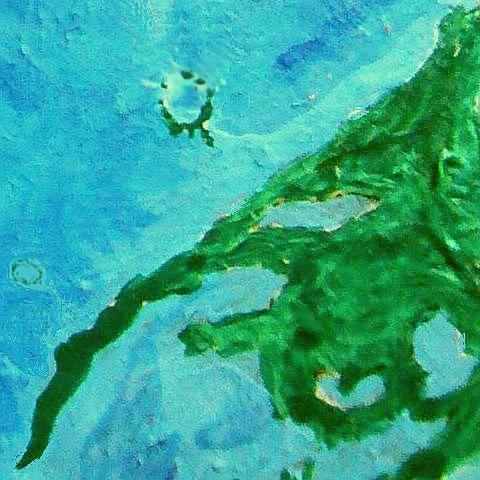
The only islands in the Quebec Sea are two fascinating atolls built atop great impact craters gouged long ago into the granitic seabed. (My apologies for the poor-quality orbital photo; on my budget it's hard to get clean readouts from landsats in alternative realities. The signal degredation's appalling.) Manicouagan Crater, the larger, is nearly a kilometer deep and a good 80 km across (50 mi); its rim rose as much as 350 m (1150') from the surrounding seabed; one southern point came within 10 m of the surface. Coral, inconceivable in the cold waters of our Quebec but common in the much warmer Quebec Sea, has built extensive reefs and sandbars atop this ring; the taller southern arc has small wooded islets. Coconut palms...
St-Jean Crater is smaller; an oval or peanut-shaped ring, 40 km or 25 mi long, either one glancing impact or two overlapping ones. The center at some point filled with sediment and hardened, creating a tablemount. The shallowest point is about 30 m (100') down; coral reefs now border the shallow central lagoon, but only shifting sandbars break the surface. Dune grass, maybe, on the largest.
Ah, well. There's plenty of good land elsewhere.The lowlands of Cape St. Lawrence and Newfoundland are fertile, rainy, and mild. Nearly as big as Hudsonia, and its main rivial as a population hub in this basin.
I meant mild for lowland Inversians, of course; we'd find these woods as muggy as the Amazon. They export mangoes, coconuts and bananas to the fruit-starved Atlanteans in winter. And of course they draw tourists tired of the snow, down to the coral-sand beaches. Aah... January in Labrador. Let that warmth soak into your bones.
Introduction - North - Hudsonia - Great Is. - NE - Craters - East - Mexico - South - West - Cascadia - Beringia
South of Cape Chesapeake, the coastal plain narrows. From Delaware Bay down through Georgia, it's increasingly dry as well as hot. Winds come mostly off the land. The ocean, at least as warm as our equatorial seas, generates plenty of storms, but they mostly head west, to rain uselessly back into the sea. Now and then perverse hurricanes stray inland, but for the most part it's a VERY hot shore watered only by creeks from the highlands of Atlantis to the east. Even that high country isn't so green--steppes, high desert and dry open forest. The south rim of the Grand Canyon, maybe?
You can get a slight respite from the heat by renting wings (remember how dense the air is here) and riding updrafts inland to the Blake Plateau, 600-1000 meters up (2-3000'). It ends abruptly in the Blake Scarp--cliffs and crags soaring to 5 km high (16,500'). This finger of the Atlantis is cut off from the main upland by a hanging valley over 4 km up (13-14,000'), a high-desert basin big as Alabama, covered in bunchgrass; with mountains north south and east, rains are scant.
While athletic Basin flyers can flap up there, with effort, you can't; the air's like Earth a mile up. The Scarp is, for you, the edge of the world.
South to long Florida Bay.Two days down the sound. Near its southern tip, at Fort St. Lucie, is the mouth of the Bahama River. Inland, cutting through the low hills of the Florida Swell (600 m /2000'), is Bahama Canyon. What fed the river enough to cut such a canyon? It drains Lake Bahama, then huge Lake Andros, big as Florida (bay OR state!) Both these monster lakes, and the many lesser Bahama Lakes to the east, have long tongues cutting deep into the Atlantis Plateau; these shores are limestone cliffs laced with waterfalls up to a kilometer high, especially coming off the winding mesa called the Tongue of Atlantis. Open woods up top, desert lakes below.
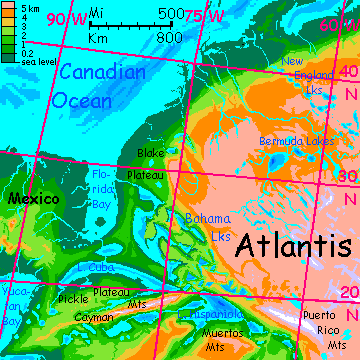
Am I sure? Evaporation's high; high enough that the lakes don't spill into the sea? Salt, alkali? But I suspect not. This isn't Earth; the high air pressure and ensuing heat stimulate constant hurricanes on the American Ocean north and west; so even rare rogue storms will be frequent enough not only to recharge the lakes, but to cause flash floods carving canyons into the soft limestone of the region.
And it isn't just local waters doing the digging. The Bahama River drains not just the Bahama Lakes but gigantic Lake Cuba further south, and Lake Hispaniola upstream of that, fed by the glaciers of Mt. Milwaukee, highest peak in Atlantis; at 8600+ meters (over 28,000') it's comparable to our Everest or K2. Lake Hispaniola is nearly as big in surface area as Cuba and even bigger in volume. Outflow, too; the south face of the Puerto Rico Range gets fierce monsoon rains off the Amazon Ocean, and that annual flood will carve an outlet even if all the lakes downstream run a net loss to evaporation year-round.
So I'm confident the Bahama reaches the sea.
Sometimes called the American Sea, this southern half of the Canadian Ocean is a dull stretch, lacking the many islands of the North. The nearest thing to land north of the Mexican Peninsula is the long sinuous Mississippi Ridge, supporting coral reefs for 1000 km north from Cape New Orleans on the Mexican shore. Marvelous diving in blood-warm seas, easily matching our Great Barrier Reefs.
But the Ridge is all there is. For nearly 2000 km north and west of this ridge, the sea is deep and unbroken. Barely Inversian--positively Earthlike! Except... warm to hot. Stormy. But most of those storms just rain right back into the sea.
Introduction - North - Hudsonia - Great Is. - Craters - East - Mexico - South - West - Cascadia - Beringia
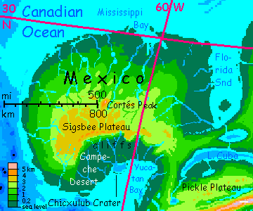
The great oval highland of Mexico, equivalent to our steamy, oily Gulf, ranges from Carboniferous lowland shores to a pleasantly Caribbean plateau 3-4 km up (10-13,000'). Even at this altitude, air pressure (and temperature) nearly match our Miami. Well, not in the central hills above Sigsbee Scarp (over 4 km; Cortés Peak hits 5200m (17,000'). They're more like the southern Appalachians; some years snow dusts the highest peaks.
The land's distinctly drier than Florida too, especially in the lowlands. Storms here are seasonal--a true monsoon resembling Northern Australia's. Short fierce summer rains and a long winter drought, though occasional off-track hurricanes lengthen the rainy season--unpredictably. The reason's simple; much of the year, prevailing winds are descending off Atlantis to the east; blowing off land, they're relatively dry. The uplands get more moderate and reliable year-round rains.
On Mexico's south shore around Yucatan Bay is the Campeche Desert, the only true desert in the region (bottom-center. Remember it's an altitude map, and the Campeche's a lowland, so its color is deceptive: deep green. Nothing green on the ground, believe me.) The Mexican Highlands to the north and the Cayman Range in Caribbea to the southeast both rainshadow this unfortunate valley. The heights send down streams feeding huge Lake Cuba, but this and Yucatan Bay itself are the only sources of evaporation to generate rain here, and big as they are, they can't compare with the oceans of Earth. And at this relatively dry latitude you need an ocean!
Horrific heat here--relentless sun and dense air to trap the heat. Routinely 45°C (113°F) and occasionally up to 60°C (140°F).
The desert hides a fascinating feature, thought--Chicxulub Crater, nearly 150 km across (90 mi); scar of the impact that killed off Inversia's dinosaurs. Erosion has broken this ring so it's hard to trace from the ground, but enough has survived in this dry climate to be traceable from the air, and since natives of the Inversian lowlands will surely be fliers, they'll have known of it from time immemorial. The question is, how quickly will they recognize it as an impact scar, and realize it caused a mass extinction? It did on Inversia, same as Earth, of course. Its target was half land and half sea, just with the halves reversed from Earth; so the impact kicked up much the same dust, and devastated Inversia too. It's one reason I'm projecting flying mammals and birds, not dinosaurs, even in the ocean basins where the climate should be dino heaven. It was--but they're gone.
My guess is that the natives, even if low-tech, will indeed be aware of the crater, since so many can fly. Given how hot the region is, the only way you can see it is to do the same. On some of Planetocopia's world with low gravity and dense air, I've encouraged travelers to tour all over using strap-on wings; but while Inversia's lowlands do have dense air making flight just possible for small, fit Terrans (kids, many women, skinny tropical guys, crazed hippie bike messengers) it's marginal and exhausting; more a sport than a way to get around. Plus, it's hot country. So I decided most of these lowlands are best toured by ship, not with strap-on wings.
But hang gliding is the only way cold-adapted Terrans can see Campeche Desert. The fierce heat and rugged country make for strong updrafts, so flight here's easy. The mile-high Campeche Scarps bordering the desert on the northwest are spectacular (and generate especially big, ridable updrafts); Chicxulub Crater, though mostly buried, may be traced by the astute glider from a mile or two up. It's cooler up there, too.
Disclaimer: I didn't say cool. Cooler.
CARIBBEAN HIGHLANDS
Eventually this will grow to a short side tour or maybe a separate Caribbean tour: a triangular trip from Miami along Lake Bahama and the shores of Hispaniola to Puerto Rico, beneath its icy peaks. Then west along the south face of the Cayman Range--the Jamaica Valley--then northeast along Lake Cuba. But for now...
The Mexican pattern is repeated to the south in the Caribbean Highlands, where the snowy Caymans (Andean in height) and the Puerto Rico Range (Himalayan) rise above some of the hottest lowlands on Inversia, around Lake Cuba. The shores of Lake Hispaniola and Lake Rico, upstream, aren't quite as hot, but almost; and more humid. These two lake basins are out of the Caymans' rainshadow, so during the summer monsoon the lakes will swell with runoff from the heights. A casual look at a Caribbean map might suggest they'd drain down the valley of the Antilles Lakes to the southeast, but there's a narrow but mile-high ridge between the Virgin Lakes and Lake St. Croix--the Anegada Divide.
Introduction - North - Hudsonia - Great Is. - Craters - East - Mexico - South - West - Cascadia - Beringia
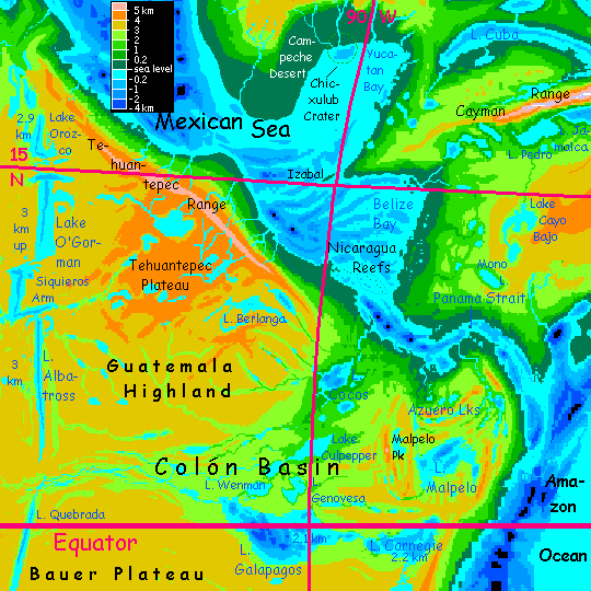
This winding, narrowing funnel of a sea lies in a gigantic valley, rivaling Mariner Canyon on Mars: 2000 km long, hundreds of km wide, and 3-6 km deep (10-20,000').
You sail southeast past the Isle of Izabal, the last gasp of the Himalayan-size Cayman Range to the east (the equivalent of our Lake Izabal in Guatemala, last gasp of the Cayman Trench).
A day later, you reach the Nicaraguan Reefs (our Lakes Managua and Nicaragua, while huge, are too shallow to become islands on Inversia).
By now the tropical rains are constant; a pattern extending all the way down through the Panama Strait into the Amazon Ocean. Nothing on Earth today is like it; maybe back in the Carboniferous. Fortunately, it's cloudier and rainier too, or you'd be dead. You rarely see the sun. But even in the warm rain, it's exhausting for Terrans to visit at sea level, and dangerous to stay long; one sunny day well above 40°C--with high humidity.
The Colón Rainforest is one of the few spots on Inversia where a rare lack of high coastal mountains allows storms off the torrid Deeps to sweep thousands of km inland. A gradual rise; most of the basin is 2-4 km high, an altitude range where air pressure (and thus temperature) are much like Earth's tropics. Rich land, and culturally more Basin than Pacifican; fliers can and do live here, especiall in the lower reaches.
Here you face a choice: south into The Amazon Ocean [under construction, don't click yet!], then the (chilly) southern highlands, or up the western shore of the Canadian Sea.
Eventually there will be a third choice, to head up the lush Colón Valley to the Galapagos Lakes and into Pacifica around high-altitude, freshwater Rapa Nui Ocean; this is one of the mildest, rainiest, fertilest stretches of Inversia's generally cold dry highlands. Unfortunately, it's not ready yet; took me all day just to rough-map the complex basin between Panama, the Galapagos, Albatross Lake and the Tehuantepecs; just a couple of million square km! A mere quarter-billion to go... sigh!)
Introduction - North - Hudsonia - Great Is. - Craters - East - Mexico - South - West - Cascadia - Beringia
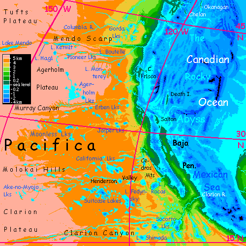
Up the southwest coast, the Canadian Ocean is opposite the huge dome of Mexico and often downwind of it, making it drier than in the Narrow Sea; but the widening water's so warm it doesn't take a broad stretch to generate significant storms; and along the Guatemalan/Mexican coast, the Tehuantepec Range rises steeply to a massive wall topping out at 5 to 6 km (16,500-19,700'), running a couple of thousand km. A wall this high wrings rain out of even the stingiest winds. So this coast is dense monsoon forest--a drier season of six months in winter, but summers more than make up for it. The mountains leave the far inland side, the Tehuantepec Plateau, some 4 km high (13,000') quite dry--not full desert, but dry grassland, sparsely populated.
Despite their great height, matching our Mexico's great volcanoes, and high precipitation from the superheated sea at their feet, these peaks are iceless--indeed, snowfree even in cold winters. Remember that the dense air of the Deep thins to Earth-normal only around 27-2900 meters (c.9000'), climatically halving the mountains' height; summits are like our tropical peaks 7-9000' high. Cloud forests up there; indeed, you'll be lucky to see the peaks at all. Plenty of white, but no ice--it's all mist.
It's a sharp contrast to the Colón Rainforest just to the south, where the absence of this wall lets storms sweep thousands of km inland. Here, enough rain to water an Amazon or Congo rainforest is squeezed into a coastal strip just 1-200 km wide.
The result: soggy.
The Baja Peninsula and the Sea of Cortez are jungle to the waterline. Given to total climatic reversal, it's funny how topographically similar the region is--the long peninsula's just rooted to the south and the long sea to the north, now. The population will be vastly higher, though; the intelligent fliers almost certain to rule the Canadian Basin will love farming the lush rainforest canopy here. Fruits, nuts, leaves, honey...
Salton, Salada and Death Islands. Funny names for such green Edens, but them's the rules. Invert topography and you invert climate; invert climate and Earth's descriptive nomenclature goes wonky. Death Island in particular shows how vigorous geologic forces are here on the western shore--in the east, we were dealing with tens or at most a few hundred meters--depths that coral can offset. But here, some 300 km offshore, our Death Valley becomes a ridge rising abruptly 3450 meters (11,330') out of deep sea. From krakens up to a coconut Eden. Death, my favorite vacation spot.
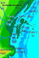
We sail northwest 700 km to the San Francisco Peninsula and the Sacramento Reefs, sheltering Marin, Mateo and Tomales Bays, three of the world's great anchorages (reversing land and sea on a great harbor often yields... a great harbor). But greener; Earth's Bay Area has famously foggy wet zones and Mediterranean dry zones, sometimes just yards apart (yes, yards; hike around the small hill called Mt Davidson). Inversia's Bay Area is all wet. And steamy. Manila? No, even warmer--and the rain won't cool you. These Franciscan rains are warm to the touch.
400 km north of these harbors, at the Mendocino Fracture, a sudden change in the coast from steep mountains rising to 3, 4 or 5 km within miles of the sea, to a much more gradual slope letting in the storms of the Deep; like the Colón / Galapagos Basin, but temperate this time. Cascadia! A few million square km of hills, basins and lakes climatically rather like Earth at this mid-latitude--neither Amazonian like the Deeps nor Tibetan like the highlands. Weird. And rare on Inversia.
Introduction - North - Hudsonia - Great Is. - Craters - East - Mexico - South - West - Cascadia - Beringia
For the first thousand km, this coast is a simple line. But past Cape Puget, it's a tangle of lakes, capes and sounds. Intricate "fjords", coral ridges and blue holes, reminiscent of Earth's Bahamas, from Lake Vancouver all the way northwest to Alaska Bay. Coastal islands just north of Cape Fraser: Pitt, Alouette, Slate, and Harrison are the biggest.
The biggest lake by far is Vancouver, more than 500 km long. A freshwater sea quite comparable to one of the larger Great Lakes (and, to the north, Lake Haida and others rival Erie and Ontario).
This stretch has the deepest part of the Canadian Ocean offshore; the upside-down reflection of our rugged American West. Thus, islands far offshore are few:
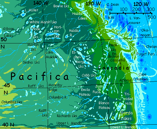
The map's green zones have air denser than Earth's at sea level, keeping winters mild (and flight easy). Dense broadleaf forests and orchards. The dark bluegreen zone, 3-4 km up, is hard for fliers to travel in. It's colder but equally dense conifer forest--substantial snow every winter here. The paler bluegreen is thinner taiga forest, like Canada's north woods--not too fertile, and essentially unflyable, with air pressure less than half normal for Inversian basins. Higher yet, thousands of km inland, the dull gold is cold prairie 5 km up--not tundra, there's no frozen subsoil, but long winters and hot dry Continental summers discourage trees. It's a bit like our Canadian High Plains, but even higher, cooler and drier. We're a long way from the sea.
I'm describing this odd mezzanine-land here, not just on the Northern Pacifica tour, because Cascadia's low enough for fliers; so culturally and biologically it's part of the American lowlands. I define highlands as "air too thin to fly comfortably in"--that is, above 3-4 km high (10-13,000'). Populations, transport, communication and economics above and below this line might as well be on alien planets--but in a few zones like Galapagos and Cascadia, the two worlds mix.
Introduction - North - Hudsonia - Great Is. - Craters - East - Mexico - South - West - Cascadia - Beringia
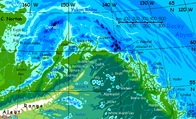
Cascadia does end--gradually. Our great mountains at the junction between Alaska, Yukon and British Columbia--Logan, St. Elias, Fairweather etc--sharply separate Alaska and the Yukon from the Panhandle and BC to the south. But on Inversia the mountains are just deeper deeps, smoothing the coast--Earth's fjords and ice-gouged lakebottoms no longer go below sea level, so no islands. But the deeps affect climate not at all.
All of this long coast is much the same--mild, lush, fractal shores, lake-dotted lowlands rising gradually to heights where the climate resembles Earth at this high latitude. Eventually, of course, that means ice. You won't miss our drowned Denali, St. Elias, Mt Fairweather or Glacier Bay. The long arc of the Aleut Range is higher yet, and glacier-mantled.
I think we'll skip Kenai Bay and the Lake Kodiak basin; there's a more scenic way to get a close-up look at the Aleut Range. Past Cape Cook, we veer southwest, up Aleut Sound. It won't take long--it's just a thousand km or so, at the feet of the glacier-mantled Kodiak and Aleutian ranges. Lake Unalaska, at the sound's head, is that weird, opaque turquoise you only get from massive amounts of glacial silt. Like a cartoon of a lake.
Here you can transfer to a lakeboat and sail another 1600 km up the Aleut River, all the way to Lake Komandorski. Then it's an easy climb east over a spur of Pacifica's great highland--only 4.5 km, (14-15,000'), then down to Kamchatka Sound on the Asian Ocean. It's a bizarre canyon, this inversion of our island arc--lake-dotted with snowmelt from above, but rather arid away from the banks. Prairie, gold and dry most of the year, for the heights on either side block most rain--the Bering and Kamchatka Plateaus rise 3-3.7 km high (10-12,000') to the north, and the Aleutian Range rises 6-7 km (20-23,000') to the south. Not quite Mariner Canyon, but almost Martian. Warm, even hot, though; air pressure's 1.5-1.7 atmospheres, holding heat on the floor. Winter snow? Rare. This could be the savanna hills of California or Morocco. Except for the scale of those monsters on the southern horizon...
You could take a side trip on this side trip--up Bowers Canyon, climbing slowly to the Aleutian Plateau, through Attu Pass, and down Shirshov Valley. This sinuous crease is an old arcuate trench a lot like Aleut Canyon that's crushed and distorted under pressure from the south--I think. But it's a reasonable guess: similar twisted features wind across our Mediterranean Sea, the former Tethys Ocean, now being slowly squeezed to death. Shirshov too will lead you down out of the Canadian Basin to the Asian Ocean; a longer trip, but Attu Pass is lower, just 3600 meters (nearly 12,000')--just flyable for deep-dwellers, where the Komandorski Spur must be climbed on foot.
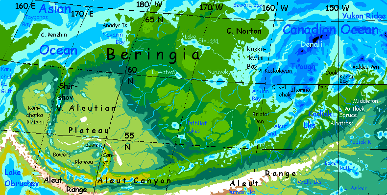
Both are too much work for me. Instead, let's take the easy way. Glide back down the river and sail on out of Aleut Sound, north through Iliamna Strait, and along the low lush coast of Beringia. Fertile, temperate coastal plains, more English/French than Alaskan, stretch hundreds of km far inland before rising suddenly to Alaskan forests on the Bering Plateau. Instead of the few thousand people this Alaskan region supports on Earth, the Inversian population will be millions. Orchards all over, with some pastures inland. It's another Hudsonia--remember Hudsonia?--but with a trade advantage: closer to the vast markets of the Asian and African Basins.
Northwest across the island-dotted mouth of Kuskokwim Gulf, round Norton Head, into Seward Bay, and west a day, back to...
...the Bering Canal.

CLICK A REGION for local maps & illustrated tours. Many areas still lack tours, though. These are done:
Arctica -
Canadian Ocean -
Amazon Ocean -
Medimarea -
African Islands -
More worlds: see Planetocopia
World Dream Bank homepage - Art gallery - New stuff - Introductory sampler, best dreams, best art - On dreamwork - Books
Indexes: Subject - Author - Date - Names - Places - Art media/styles
Titles: A - B - C - D - E - F - G - H - IJ - KL - M - NO - PQ - R - Sa-Sk - Sl-Sz - T - UV - WXYZ
Email: wdreamb@yahoo.com - Catalog of art, books, CDs - Behind the Curtain: FAQs, bio, site map - Kindred sites