
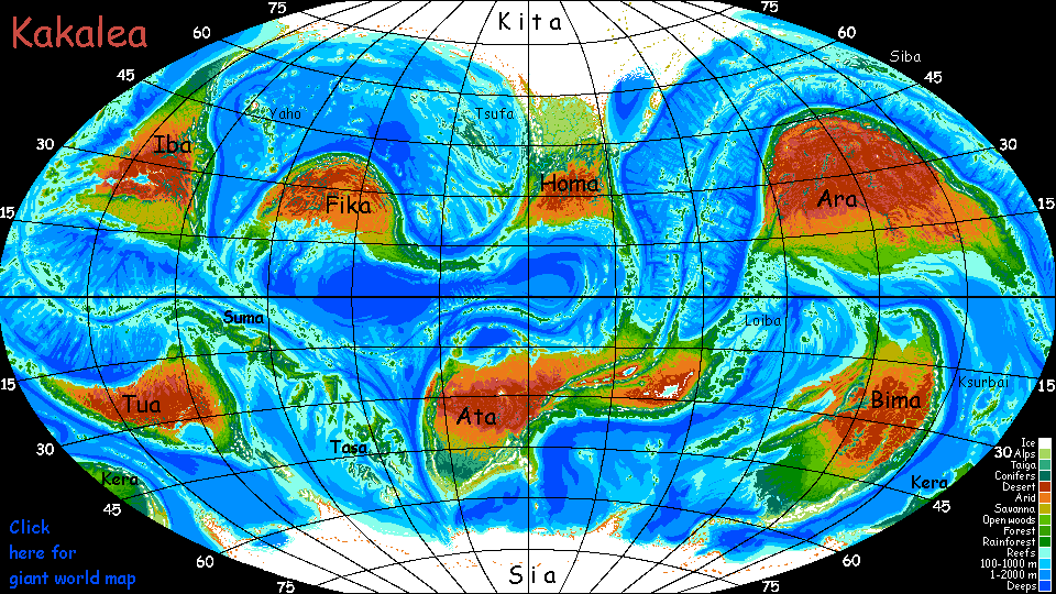
Kakalea:
ARTAHO ISLANDS
under construction--partly outline
by Chris Wayan, 2013-14
for the Taiwanese explorers who settled the Pacific
Kakalea basics--map--geology--
creatures--
Building Kakalea
More worlds? Planetocopia!
Kakalea:
ARTAHO ISLANDS
under construction--partly outline
by Chris Wayan, 2013-14
for the Taiwanese explorers who settled the Pacific
Kakalea basics--map--geology--
creatures--
Building Kakalea
More worlds? Planetocopia!
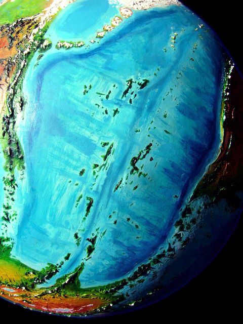
These two parallel island chains in the Artaho Sea are the tops of twin ridges flanking a long sinuous rift zone, much like our Mid-Atlantic Ridge system (or the pages of an open book--if those pages were wildly corrugated and had volcanic pimples erupting all over, not common even in the cheapest paperbacks). Our Rift is drowned so deep it went undetected for centuries, but Kakelea's seas are much shallower; deep soundings merely add details to a picture obvious to Kakaleans since deepwater seafaring began.
New crust spreads from the Rift, so all the Artaho Isles are young; most are rugged, and dotted with volcanic cones.
Since the two chains are nearly continuous, no islands are as biologically isolated as our Azores, Bermuda, St Helena or Asunción; yes, a few species here started out as storm-blown refugees from Ara to the east and Homa to the west (Kita, to the north, contributes only death: blizzards and cold dry winds), but most species on the Artahos simply island-hopped up from East Ata to the south. Gaps are never more than a few hundred kilometers, and mostly far less. For thousands of km, you generally see the next Artaho on the horizon.
Thus the fauna of the Artahos just doesn't look very 'islandy'. Few flightless birds, few oddities in general; pretty much the continental mix found on Ata, locally modified to fit the climate(s). In fact, let's start the tour on Ata's mainland...
W E S T C H A I N
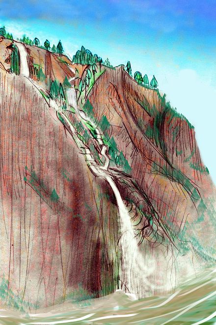
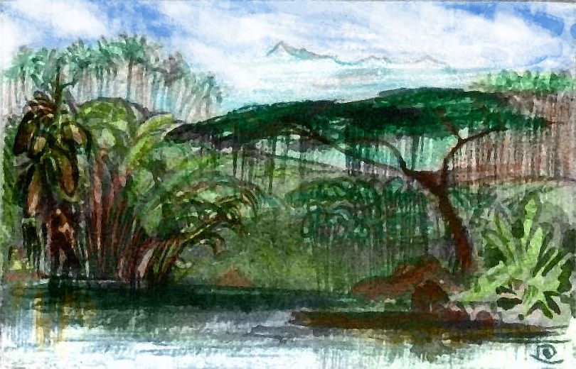
We'll embark in early summer at the tip of Cape Tsaa, the western flank of the Rift on Ata. Stretching some 500 km (300 mi), it too is land up-tilted by the Rift--rugged hills, especially on the east (the Rift) coast, where scarps rise above the sea--a waterfall a mile, though they're often hidden under lush rainforest; we're near the equator.
We'll sail on a local Kakalean vessel running north up the West Chain and back home along the East Chain. It's quite a long journey--16-20,000 km, depending on side trips. Yes, "20,000 Kilometers Over the Sea". It sounds years-long, like a Terran whaling voyage, but it's not: kilometers aren't leagues, and Kakalean catamarans are light and fast; at up to 25 kph, the loop will take only a couple of months. If the crew pushed, like a Terran clipper ship, they might even make it in one. But Kakaleans never do. No money in it, and more to the point, no fun.
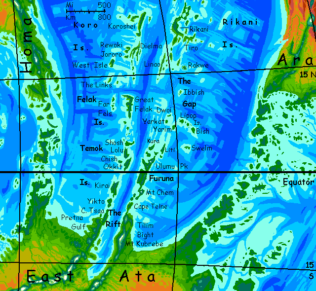
Off Cape Tsaa are the Temok Islands. These are all big--Taiwans and Jamaicas. First is Yikto, 200 km long and nearly half as wide (125 by 60 mi). Rugged rainforested hills like Cape Tsaa.
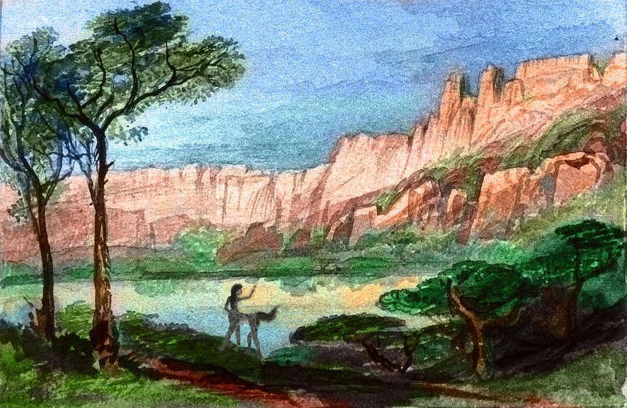
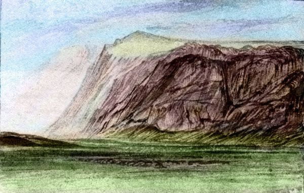
Next is Kirai, largest of the Temoks, a roughly rectangular isle 320 by 125 km (200 by 75 mi). Here too the east coast is dramatic: in the central stretch, red cliffs rise up to a kilometer from the sea. Trees cling to every ledge; white falls in every notch.
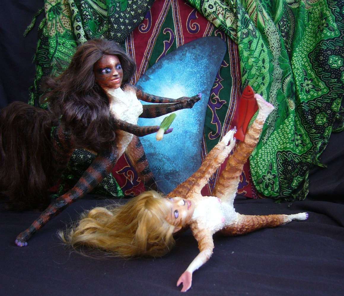
A few hours north of Kirai, you cross the equator. Terran sailors of centuries past initiated those who first crossed the Line--hemispherical virgins, so to speak--by dunking them. Kakalean catamaran crews have a similar but still rowdier ritual: everyone soaks everyone. Given the muggy heat, this is welcome as long as you're dressed to be drenched. The crew, of course, being furry little centaurs, won't be dressed at all; below the Arctic Circle, they never are.
Just north of the Line you reach Okkit, a narrow isle 270 km long (170 mi). Here your catamaran veers to port, sailing up the gentler west shore. The east is an unbroken line of cliffs with few villages and no good harbors; they're all on western Okkit and little Chish offshore ("little" as in "not much bigger than Maui").
To the northwest is Lolu, nearly as big as Okkit, and gentler; you sail up its east shore.
A few days exploring these quiet ports and you reach the last of the Temoks, Shosh. The same size as Yikto, and if anything wetter; the central hills and the eastern scarps are wrapped in cloud. We're still deep in the equatorial zone.
Next day, all day, it's a zigzagging run north from Shosh up a line of coral reefs and islets--the end of the Temoks, or the start of the...
The Felaks start unimpressively. Two days of reefs and green islets smaller than Oahu. But the fourth such narrow isle turns out to be deceptive. It's a narrow but very long island: Great Felak, 500 by 175 km (300 by 110 mi). Three days up the rugged east coast--not, like the Temoks, a straight line of cliffs, but a jagged wall punctuated by long heads at right angles. This curious coast is a common type seen in the rift zone; here, stretches of crust spread at different speeds; capes and bays often form along the faults between.
Great Felak ends abruptly at such a fracture--the coast suddenly turns west along the fault. Here, cliffs face north into the sea, even greener and mistier than the east. Storms blow south during the summer rains to slam directly into these scarps. Cloudforest clings, getting several meters of rain a year. But it's a bit deceptive--just a narrow strip. South and west Felak, over the ridge, is much drier; open forest and even savanna in some valleys. Winters are mild and nearly rainless, though summers bring typhoons.
Why dry coasts, dry seasons? Over the last week or two you've crept from 6° south to 12° north. Catamarans are fast! You're still in the tropics, but leaving the equatorial belt. From now on, seasons matter--and orientation to the winds.
Great Felak's northern scarp gradually lowers and sags at last into the sea. Your vessel, though, doesn't turn north seeking the next of the Artaho Isles, but continues west overnight to the Far Fels, a modest, merely Hawaiian chain--the tips of a second corrugation-ridge. There's a reason. Had you headed due north, you'd have found deep water--over a mile, I mean--then nothing for days but reefs, sandbars and flyspeck islets with little to trade. Only after visiting the ports of the three largest Fels (sail south to go north? Apparently!) does the crew vote to turn north again.
Vote? Yes. Kakalean catamaran crews are cooperatives, not captained hierarchies. True, the shift on duty will rush to obey the pilot and steerswoman; at up to fifteen knots, a cat sails far too fast for debate--not in a tricky reef-zone like the Artahos, at least. But strategic decisions, as opposed to urgent evasive maneuvers, are group affairs.
North a day over blue deeps--the same fracture zone that created Great Felak's northern cliffs. After a small island, East Link, the next landfall is West Isle. You're startled by Shelter Bay, the best harbor, on the southwest coast: open, rather dry coastal flats. Dry grass, a few spindly trees, bare rock outcrops. Near the latitude of Hawaii, West Isle has a similar pattern--lush windward shores and rain-snagging hills, but more arid leeward shores, as here. Next day, your cat sails east then north up the length of this 140-km island (85 mi); green again. Still, it's a wake-up call. I told you cats are swift.
Back east a day to the heart of the Koros: Dielma Sound. To the north and west, little Jororo and Rewoki; to the east, Dielma itself. This spindly giant (that wobbly, upside-down fork on map) is all coast and no interior--a branching ridge complex. Corrugations in a vigorous spreading zone. Unfortunately, these ridges lie directly across the prevailing winds, so each has a wet and a dry side. You're sailing up the dry. Not utter desert--creeks come down every few miles. A village at every little delta, with irrigated fields. Pleasant enough, and certainly lots of sun. Just be sure you trust your neighbors about water allocation! The squabbles on Dielma's water boards inspired a popular tragicomedy played on showboats all over this ocean: Talked to Death. No sick jokes about waterboarding as torture, please; they're all too appropriate.
|
Jororo and Rewoki, on the west side of the channel, catch more rain and have fertile shores; there's a vigorous local trade swapping foods and fibers from rainforest to savanna and vice versa.
The dance-play to come out of that is a comedy, We Leek Fish--at least the pun is close to that. More double entendres follow. Lots of smutty innuendo. Though the sexual allusions are open and innnocent; the dirty jokes, for Kakaleans, are about the greed revealed by the lead dancer, Lotora, whose seeming kindness hides a self-centered rationalization (illicit, even obscene to a Kakalean! A good bargain here means everyone's happy.) This production underscores it by dusting her coat till she resembles a mukira, a raccoonlike little mammal of thievish appetites.
The plot? Lotora, a gardener on the rainy coast of Rewoki, schemes to convince a naïve young Dielman called Filia that leeks are a cure-all for parasites, so Lotora can swap her stinky stalks for delicious salmon jerky, which Filia dries and smokes on Dielma's rainless west coast.
Such trade is common. This may seem odd to Terrans. Why go overseas, why not trade with the dry side of her own island? It's much closer after all. But this never occurs to anyone--not in the play, not in reality. It's just easier to ship across the channel--just a few hours' easy sail--than to lug the stuff over the nearby mountains, a hot, buggy two-day hike.
And despite the farce, the play's portrait of trade is realistic. Most trade is maritime, and shipping networks define your community more than the name of your island. The dirty joke is seeing Lotora's appetite seduce her into cheating family.
We've seen something similar in the continental tours--folk consider themselves natives of this or that coast, not of a continent. But it's true even on small islands. Kakalea's land transport is backward--poor roads and few wheels. But Polynesian-level shipbuilding skills are common, and mariners have woven travel nets worldwide. And identity follows.
In European languages 'island', 'isolated' and 'insulated' are close cognates. Not on Kakalea! Here the land's a barrier--inland is "outback" in every tongue. The sea's their highway. And news channel! A worldwide web.
North to huge Koroshei (an easy name for English-speaking punsters to remember: think Crochet--appropriate given the hook). One of the biggest in the Artahos, 450 km long and 125 wide (280 by 75 mi), Koroshei is like a fattened-up Dielma: forested uplands but semi-arid leeward coasts and inland valleys--scattered trees and grassy hills dry half the year. We're at a relatively dry latitude, and downwind of the huge desert continent of Ara, so winter rains sometimes fail. Still, such droughts are balanced by occasional hurricanes...
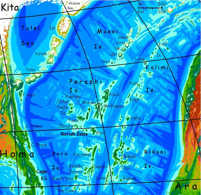
The Perazhis are a huge, mild-temperate archipelago, the largest cluster in the north--triple the Azores in every dimension and you have it.
The southern Perazhis are called the Rorish Isles. They run east-west, a rarity in the Artaho archipelagoes. This converse strip is a fracture zone in the great rift; the segments north and south of Ror spread at different rates and slightly different angles.
Ror, the first and largest, is 240 km across (145 mi), a complicated mass of ridges round a central volcano. Rugged capes shelter bays all round the island--good harbors, varying from lush forests to open woods to bare, rocky savanna. A continent in miniature! Two days circling Ror, sampling its sights and wares. Be sure to try the wines (not very Terran, more like raspberry liqueur, but interestingly complex) and the pickled sicha buds (spicy-sour-salty and hilarity-inducing, rather like Terran laughing gas) if your religion permits a mild, quick-dispersing recreational drug reputated to be a health-tonic.
If not, consider changing religions.
The Rorish themselves worship--well, appease--a rather grumpy earthquake-god. They're indifferent to volcanoes and typhoons; those are business as usual. But fracture zones are especially earthquake-plagued, even for Kakalea, where most people live on quakeprone coastal strips between Andean mountains and deep trenches. You notice all the houses, even theaters and music-inns (the Kakalean public buildings) are light, thatched affairs. No brick walls or slate roofs here!
West through the Rorish Isles. Mostly small, though Chirura at the west end is nearly 150 km (90 mi) long. But all low and narrow; scrubby woods. Villages only on the creeks; harbors only at their deltas. Silty little streams, each building a muddy bar and a small lagoon. Another reason for such a light catamaran! Most Terran sailing ships would snag on the bar. Not a deepwater port in the whole chain, after Ror.
North to the western Perazhis. We'll skip the Outer Yaolas--much like the Rorish Isles, just a bit smaller. The Outers are rather isolated and backward--too many ships vote to skip this dead end, so they only get trade from vessels stopping on their way to and from the continent of Homa.
The Inner Yaolas are big enough to spend some time on. Yaola proper, an irregular mass the size (and somewhat the shape) of Ror, has the highest peak you've seen yet, a volcanic cone punching through the clouds; its shoulders are dark-forested, but the paler summit is fern-clad. Snowfree now, but not most winters. From the peak's shoulders, twisting ridges--lava flows atop Rift corrugation, all high enough to be cloud-shrouded and overgrown. Capes, bays, satellite islets, some clearly volcanic.
East to the tip of Yaola and north through the Inners. Rupitea is nearly as big as Yaola itself. Its east shore seems as lush as any to the south, but the mix has changed: a temperate-looking deciduous forest dotted with conifers, especially on the heights.
East a few hours. At first it seems we're striking out into deep ocean, but ridges soon crinkle the horizon. The core of the archipelago: Winsho and Rizizi, third and fourth largest islands in the Artahos.
Winsho: rugged, green, 500 km long (300 mi). The south seems like the Yaolas--more wooded ridges above opener coastal plains. But Winsho's north end is different--dominated by Mt Psopse, a massive volcano 4.75 km high (15,600'), with a summit as broad as Kilimanjaro's. It's heavily ice-mantled, the first ice you've seen since we set sail.
Rizizi: nearly as long, 400 km (250 mi), with tall but less massive peaks, also snowy. The coasts are still pleasant enough, but we're clearly in the temperate zone now. Mild weather now in late summer, but your ship timed this visit with that in mind. The somber forests, more evergreen than broadleaf, tell you how far north we've come... Latitude 37°!
No, that's right. No further north than Athens or San Francisco. But with the huge ice tongue of Homa not far to the northwest, winter blizzards aren't rare. Nor are they on Earth at this latitude, after all--consider Tokyo or Washington, DC.
Location, location, location...
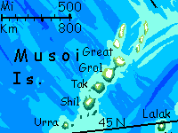
In the northern sea, the twin island chains bend east, and the "western" chain thus becomes a northern one. Too far north! Well, it's not all latitude; the Musoi Islands are just 45-50° north, no more Arctic than London or Paris; but the proximity of Homa's huge ice-tongue, far bigger than our Greenland, fouls the weather here. And of course there's always Kakalean bad luck. The Musois are more volcanic than most of the Artahos; peaks up to 3 km high. These form altitudinal seeds for glaciation; half the islands are iced over. They're mostly treeless and sparsely inhabited.
Oh, well!
Still, Musoi's a land on the edge; livable, but not much to trade. Your crew votes to skip Musoi's delights--a long detour, and still more furs and dried fish just aren't much of a lure.
So the catamaran swings south, toward the "eastern" chain... across the Great Rift. Deep water!
All of a mile.
E A S T C H A I N
Pleasanter islands here. We're really not far south of Musoi, but much further from the ice-tongue covering northern Homa and the harsh winds it generates. London's not much south of Labrador, either, but the weather's a lot milder. Ask Greenland why.
The Kalimis are small islands, but the chain is long, running south fully 2500 km (1500 mi). Climates run from almost Nordic in the Filif Islands to Portuguese on Fatta in the south. These northern isles are low, fertile, dark-wooded. They do get winter snow, but not the long freezes of Musoi.
Our goal is the one exception: the high snowy cone of Lalak, an island that's essentially a single volcano 3.8 km high (12,000'), like a runaway Aleutian island. Lalak is no freak or giant, no Hawai'i; quite ordinary in scale, both for Earth and Kakalea. It's just rare in this stretch of the rift. Hundreds of volcanoes this big rise from on the slopes of our mid-sea rifts, too; but most rise in much deeper water and remain hidden. Or they broke the surface only to get beheaded during our Ice Ages--lower seas let their exposed summits weather, and when sea levels rise again, they end as reefs and guyots, about 100 meters down. Not on Kakalea!
Lalak has, paradoxically, both the coldest and warmest weather here in the north; the high peak generates its own foul weather, but also shelters the south shore from arctic blizzards and tilts the land toward the sun. Broadleaf forests and farm towns sunbathe along this favored little strip just ten miles long. It's as if you'd stumbled into Middle Earth, and after days in the cold northern wastes, you suddenly reach the borders of the Shire--or, better, Bree. A country in miniature. It's why we came. Best market for restocking in the North.
The central Kalimis, south of Lalak, aren't a single chain but long parallel ridges--here the spreading crust corrugates again, crumpling under pressure. Small, rugged but fertile islands. The coasts verge on subtropical now--snow is brief most years, and sometimes absent.
V-shaped Yosh is 145 km long but only 25 wide (90 by 15 mi). Forested ridges, but gardens and farms in the valleys.
Irlem and its sisters to the south are equally long and narrow. Small villages, all with that salt tang in the air. But fertile little worlds--subtropical trees flourish here that struggle on southern Lalak; though the locals can only grow ones that are salt-tolerant. There is no inland inland, so the salt spray from winter gales gets everywhere.
Next: a full day's sail with no land in sight! A rare thing on this trip so far.
Next day: the southern Kalimis: first the surprisingly gentle hills of Fatta, 125 km across (75 mi). There are landlubbers here who've never been to the beach, let alone sailed overseas. Rich farmland.
But you're not concerned with hayseeds. Your boat heads for the huge natural harbor on the north shore, Ottika. It's become a hub for east-west shipping to and from Homa and Ara, not just island traffic like your little cat. Some of the cargo and passenger ships you see are 30 meters long--still catamarans, still lightly built, but running transoceanic routes just as fast as Terran luxury liners in their heyday. True, no ballrooms or pianos... but no snobbery or steerage-class either. If you're on the boat you're part of the herd, for the duration. A lot of intercontinental travelers get good-for-a-month tickets; they get off here, roughly midway, and decompress from the first fiveday of cramped accomodations, and gallop around town (or the whole island) for a few days, dance in the music-inns and see the shows in the town's extensive theater district, then board the next shuttle heading their way and either finish in one stretch or take a second break in the West Chain. It's not so different from what you're doing, really; just more sailing and fewer ports.
STEAMPUNK... NOT!
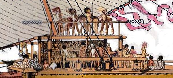
Kakalean captains will be glad to take up radio, but I'm not sure these seas will ever see an Age of Steam. Centaurs hate being cooped up, their fur keeps them comfortable in all but really cold hard rains, and as herd creatures they expect to help out; passengers are basically interns for the crew. So the paid crew is not huge, and mostly involved with navigation and sailing itself, not maintenance or cooking. So these fast catamarans are rather economical; I'm not sure steamers could compete.
A sailor's life is hazardous, but for different reasons than on a Terran clipper ship. Scurvy or other diseases of malnutrition are unknown--catamarans are fast and islands are everywhere; a Kakalean Magellan could restock every week. Even untrained centaurs are decent swimmers--they can dogpaddle with four or even six limbs and keep their nose above water even in cold seas for several hours, so unless their ship sinks away from traffic lanes, they rarely drown. They can die of hypothermia, but their coats slow it down; hours or days, not minutes. Rigging is much simpler so fewer limbs are lost from stray loops, snags and coils. With just one sail, fewer crew need to climb the mast--usually just one lookout--a surprising number of Terran sailors in the golden age of sail died of falls. Most injuries on these cats are on deck, from tacking. Here's why:
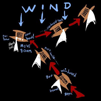
Kakalean catamarans have a Polynesian lateen rig--the way you come about into the wind is strange. You luff the sail and while the pressure's off you unstep the boom which isn't affixed to the the mast but to a socket in the deck. You slide it back along its slot to the rear socket (using loops as handles--NEVER put paws in the slot!) and suddenly the stem of your ship is the stern--when you grab the wind, you're running in reverse. Both bow-sterns are sharp, so no matter--she's just as fast in reverse. Off you charge in a new direction!
All this means the windward side is always the windward side; so the two hulls can specialize, be asymmetrical. The smaller lighter one, staff-only and packed with supplies, is used as a windward outrigger or weight, not always even in the water--it bucks pretty fiercely, so you don't want to be over there. Passengers stick to the decking near the leeward hull (still a rather wild ride, but at least not a Vomit Comet). The windward hull, basically a huge counterweight on a long lever, lets you raise a single, simple, huge lateen-rig sail snagging incredible force even in moderate winds--a single-hull vessel under that topheavy rig would capsize. A non-cat is faster to come about in tacking, and safer--slip while moving the boom and you can crush a leg or lose a hand--but Kakalean cats reach and run MUCH faster.
BACK TO OUR VOYAGE
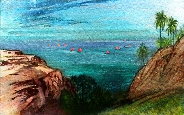
Leaving Fatta, round the island's shores a few hours, always with at least a dozen red yellow and white sails in sight--and then back to just a handful. The inter-island run is minor.
South. Two days of lesser islands. Definitely subtropical now. Chill rains in winter, but snow is rare even on the heights. All the harbor markets offer dark green sugarleaf, lemongrass, mangoes and citrus (well, equivalents).
The Rikani Group. If the Canary and Cabo Verde Islands had a horde of grandchildren who all stuck close to the nest, you'd have something like this region. Warm, pleasant islands. About the driest and grassiest in the Artaho Sea--we're off Ara, the huge desert continent, and it casts a weak rainshadow even this far out. Still, winter storms come pretty reliably after the long dry summer. Like most of the Artahos, the Rikanis are quite rugged, a chaos of ridges and volcanic cones; and those heights snag rain. Even the coasts get enough for scattered pseudoaks dotting golden hills. Surface water gets scarce in summer but pools, wells and shaded canyon-creeks remain.
Rikani proper is the second largest island in all the Artahos: spidery, but 800 km long (500 mi). Nor is it alone; Linao, in the southern subgroup, is 370 km long (230 mi). Rikani's strange shape--almost a grid of ridges, forming capes and bays but also trapping lakes--is the best above-water example of the Rift's flank-structure; the sea bed for thousands of kilometers resembles Rikani. Corrugation from compression as more crust is forced out of the Rift; but at right angles to these, faults and ridges where zones spread at different speeds. The result is almost fractal. Undersea, such ridges are long-lived; not up on land! In mere millions of years, erosion gnaws them down, filling in bays and lakes with the sediment. So young isles like Rikani, right next to the Rift, show this fractality best.
The southern satellites are greener, a bit less naked, but equally rugged. Linao is a narrow sliver of an island, 360 km long but just 40 km at its widest point (225 by 25 miles). Impressive cliffs on its long western face--fresh crust rising from the Rift. Your ship does you a great courtesy here--most of the villages and all the good harbors are on the gentler east shore, but the ship wastes a day reaching down the west coast and back, to see the cliffs. No money in it, but Kakalean catamarans are fast, and the crews are locals (Artahoans I mean, from all over these isles, not Linaoans) full of local pride.
As you explore Kakalea, remember that in our Age of Sail, most traders were built and crewed in Europe and the Mideast, but here, all cultures are maritime. Inward-looking lands like China and empires like England don't exist--sailing technology is universal.
The result? Rather than navy-like hierarchies and tightly focused trading voyages lasting years, these fast little ships run circuits of a few months at most--a mixture of trade, mail delivery, ferrying, and simple sightseeing. Kakalean centaurs' easygoing character certainly adds to the informality, but a level economic and technological playing field makes Terran ambitions impractical. So these trade-voyages seem, to human eyes, almost holiday cruises.
And you thought it was just my personal bias toward anarchism, didn't you? Naaaaah.
Oh. As long as you're sightseeing... Linao's little sister Rakwe, a day to the east, has equally beautiful cliffs--but with quite a different origin. Rakwe is a rugged volcanic plug eroded by heavy tropical rains into a starfish-shape, all fluted cliffs. Earth's nearest analogy might be Moorea, though Venus has way more such features--ticks, they're called. A wild place, but hazardous to approach, as a barrier reef rings Rakwe. If the wind's from the north, forget it. Listen to your pilots!
South of the Rikani Group lies The Gap. This stretch has some small tropical islands (small as in "no bigger than Hawaii"), but none of the giants we've seen--and will soon see again. And your ship is facing the widest true gap within the Gap--a full day or more south-southeast, with no land in sight.
But even this wide passage was never much of a barrier to life spreading up the Artahos from the south. The western chains have islets all the way.
Your ship zigzags through this non-archipelago. First landfall: Ibbish, about 80 km long and nearly as wide (50 by 40 mi). Low, hilly, irregular--more a mass of linked islets or low hilltops rising from a shallow sea.
Next day is a second landless gap southeast from Ibbish. You reach land only near sunset: Dwoi. Little Dwoi, and Yarkat to the south, are each barely larger than Oahu.
From Yarkat, you turn southeast to Yarim, then a day northeast to the Lipop Islands. Lipop itself is 125 km long (75 mi), with a ragged coast and numerous villages in its many coves. The hills are a lush green, not the olives and golds of the isles north of the Gap. We're well into the tropics now, and summer rains are heavy.
Southeast along the Lipops to Bish (largest island in the Gap, some 175 km long and half as wide (110 by 55 mi).
South to lonely Swelm.
And now the true gap. West two islandless days, over deep water, to the halo of isles around...
The last isle on the tour is also the largest. Furuna is nearly 1000 km long (over 600 mi), Furuna is rugged and rainforested--no surprise since it straddles the equator. Picture Java turned north-south.
The north end: twisting ridges watched over by Mt Ulumu, a snowcapped dormant stratovolcano 4.3 km high (14,100'). On Earth an equatorial peak this high might see intermittent snow at most, but on Kakalea, high gravity clutches its already-thin air tight to the lowlands; pressure at Ulumu's summit crater is Himalayan and thaws are rare. Small glaciers gleam in the sun above the equatorial clouds.
Central Furuna is broader but lower, with parallel north-south ridges of tilting, cracked strata. Here the ever-spreading crust has apparently corrugated severely under pressure. Muggy Amazonian valleys, sunless cloudforested heights.
Southern Furuna narrows again, resembling the north: sinuous forking ridges punctuated by tall Javan volcanoes. By far the largest is Mt Chem, a near-twin to Ulumu in the north: 4400 meters high (14,500').
Over Furuna Strait is Cape Telne on East Ata again, just a few hundred km across the Rift from Cape Tsaa where we began--rugged tropical mountains, emerald green--what little you can see of them, through that sea of clouds.
Congratulations. Over the last couple of months you looped some 16,000 km (10,000 mi)--as far as four transatlantic passages.
LISTS AND LINKS: More worlds? Planetocopia! - dreams of other worlds - ecology - climate change - evolution - natural disasters - terraforming - sculptures and 3D art -
World Dream Bank homepage - Art gallery - New stuff - Introductory sampler, best dreams, best art - On dreamwork - Books
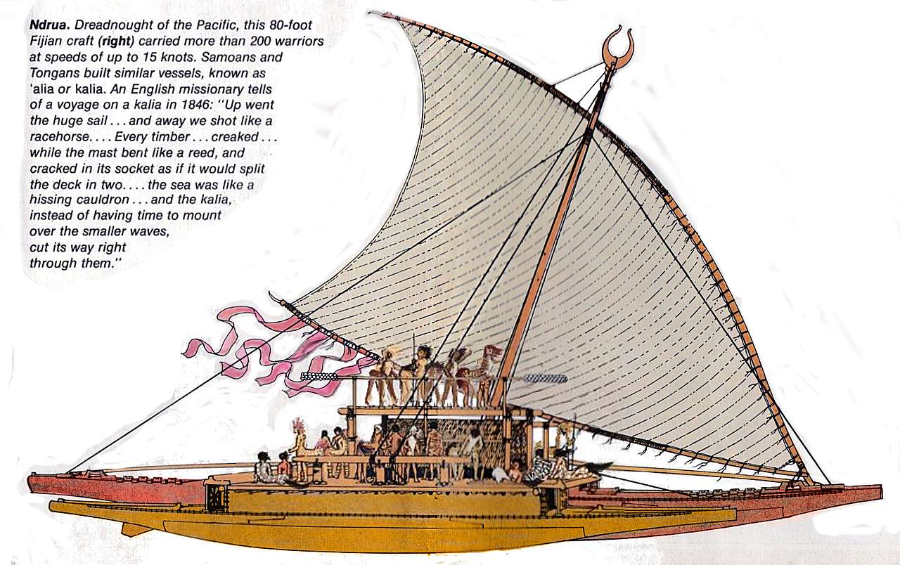
The transoceanic catamaran Pride of Choi, based on a drawing of a Fijian ndrua by Herb Kawainui Kane.
Indexes: Subject - Author - Date - Names - Places - Art media/styles
Titles: A - B - C - D - E - F - G - H - IJ - KL - M - NO - PQ - R - Sa-Sk - Sl-Sz - T - UV - WXYZ
Email: wdreamb@yahoo.com - Catalog of art, books, CDs - Behind the Curtain: FAQs, bio, site map - Kindred sites