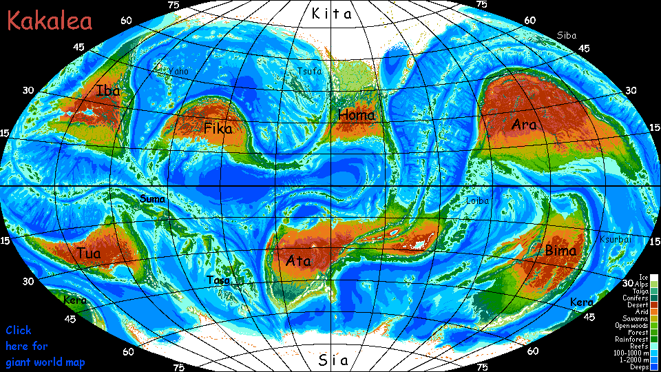
Kakalea:
West Ata
by Chris Wayan, 2012-2015
for the Atacamans, all twelve of you
Kakalea basics--map--geology--
creatures--
Building Kakalea
More worlds? Planetocopia!
Kakalea:
West Ata
by Chris Wayan, 2012-2015
for the Atacamans, all twelve of you
Kakalea basics--map--geology--
creatures--
Building Kakalea
More worlds? Planetocopia!
INTRODUCTION
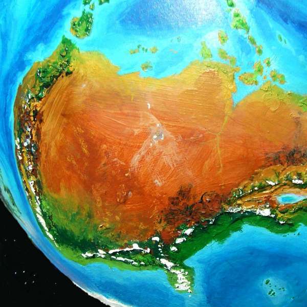
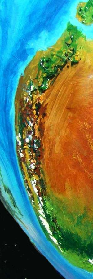
Ata is big. At 35 million square kilometers (14M sq mi), it's almost as big as our Asia. It's the biggest continent on Kakalea--probably. Kita-Homa, the north polar continent with a huge unfrozen lobe, may be as big as Ata--certainly it comes close--but it's hard to tell under all that ice.
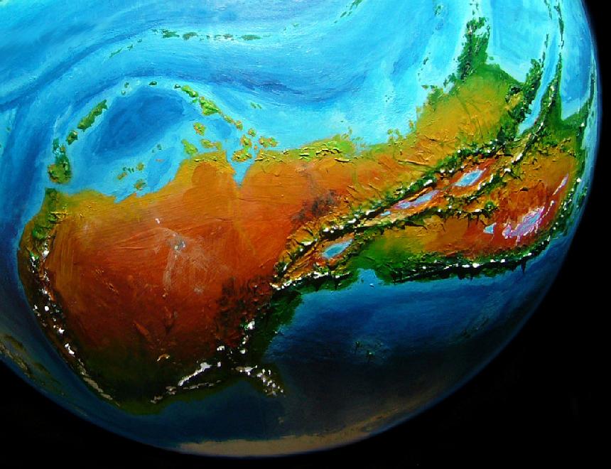
Ata's two-lobed, East and West; because each is continental in scale, I'll treat them separately here.
East Ata is mostly fertile, though it has one of the nastiest deserts in the world, a salt- and alkali-poisoned basin below sea level with salt lakes full of halobacteria; their pink is visible from space. But the most prominent feature in the East is a huge rift zone that comes ashore much like our East African rift--like ours, the East Atan Rift raises wide fertile highlands around it, breaking up what otherwise would be another hot dry Kakalean outback.
West Ata is bigger but less fertile overall. Atypically for Kakalean continents, most of its biomass is in the temperate zone, some of it subpolar--quite Nordic. Almost an antipodean Europe! But the bulk of West Ata is desert. No surprise there; it's true of every large continent but Bima. But West Ata, if it were a separate continent, would be the desertiest of all: over 70%.
We'll start in the northeast on the assumption that most readers came here from East Ata. If so, the shore's the only sensible route.
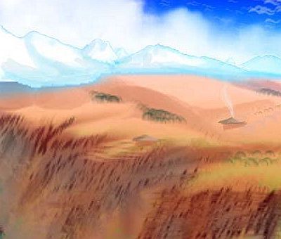
NORTH SHORE AND DESERT
As you leave East Ata, sailing west along the shore, you find few creekmouths. If you land to trek inland here, the coastal savanna thins quickly to desert--dreary flats like a southern-hemisphere version of our Sahel or the monsoon zone of northern Australia as it fades into Outback. Northern ports are small and poor, since they only serve the coast itself. Rivers are few, short, shallow and seasonal. West Ata's interior, though not cut off by high mountains here, is still hard to reach--Kakalean land travel just isn't sophisticated. With no reliable rivers, mines inland can't barge their ore out. Could they send down finished metals during the brief summer floods, or year-round via caravan? No refineries inland! Smelting takes charcoal, and the desert lacks enough wood.
It only feels hot enough to melt iron.

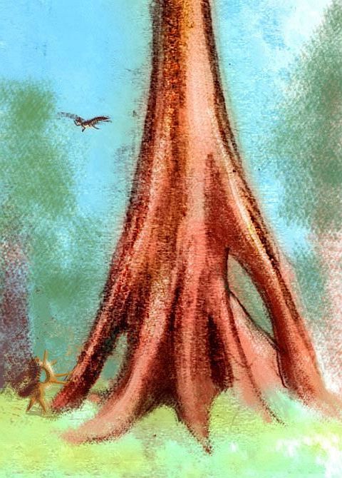
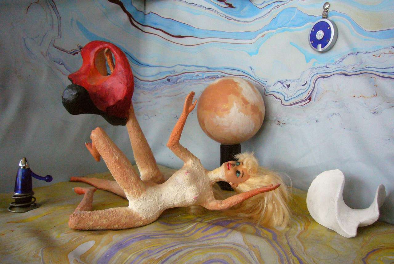
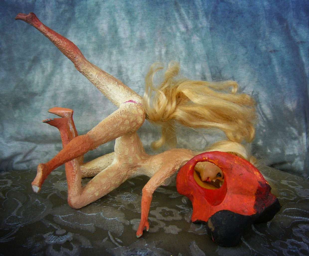
Most portraits of native Kakaleans here are female, because I'm building Kakalea in San Francisco; our thrift stores are full of Barbies but not Kens--he's all snapped up by gay/fetish doll sculptors, I guess. And it takes two dolls per centauroid, you know! I've only found two and built one--Kentaur. Now, don't jump to the conclusion that Kentaur has a huge erection and figure Kakalea's (only) furry porn. In fact, Kentaur's not horny here. Believe me, you'd know. Not big as a horse, but big. What's going on is that Kakalean males have a spur of cartilage supporting the penis so it doesn't dangle and flop when galloping (lots of Earth mammals have such structures in bone or cartilage); in its normal state, it looks a bit like a human erection. Of course he is still showing off, though unerect; Kakaleans have as much imagination as Terrans.
By the way, galloping has also affected Kakalean breasts: while extremely variable in size, position and even number, on average they're modest-sized; and a small support muscle limits bounce and flop on the run--sort of an internal sport bra. Now if a human ballerina twisted into the odd positions some of these Kakaleans get into, she'd have flattened or dangling or downright migratory breasts, but you'll note the Kakaleans look pretty much the same. If you're skeptical such support-muscles would evolve, you can blame Ruth Handler, inventor of Barbie's unnaturally rigid plastic breasts, which of course my Kakalean centauroids inherit; but this would be unkind, given her basically feminist intent (see the very funny film Barbie Nation) and, worse, postmodern. We don't go there. Kakalea is the planet of misfit toys, but there's inept and inept.
Hmm, back to the real Atan outback, not Kentaur's fabric backdrop onstage in nice cool Port Bin, offshore. Well, warm Port Bin. But at least not scorching Port Bin...
What lifestyle is most viable in the West Atan desert? Gem mining! You want to dig nice cool caves to live in anyway, so why not keep an eye open for pretty rocks?
But by the numbers, most outbackers are subsistence farmers and herders; trade means far less to them than rain. Here's a local girl celebrating the rains. No, she's not dancing to summon the rain--that would be primitive; everyone knows incubated prayer-dreams are the only thing affecting weather! She's just thanking the sky because the rains showed up at all this year, without flooding folks out. Much.
How do I know she's local? Her coloration; such longitudinal spot-stripes, reminiscent of some African antelopes, are typical of this savanna. In West Ata you can easily tell the old families from the prospecting parvenus--or rather, from the palominos, leopardspots, tigerstripes, tortoiseshells, appalloosas...
Midway, you reach the triangular gulf and delta of that scrawny desert river, the Muddy. I think you can figure out how it got the name. A couple of its arms are fed by snows from the temperate mountains of the south coast, but winter precipitation on the inland slopes of those mountains is sparse and drought-prone. And much that does collect in the south evaporates on that journey north through the lava beds and across the desert flats. Nearly drying up in some summers, it's no more reliable or navigable than it is healthy to drink. A poor excuse for a Nile!
One modest stretch is relatively habitable: the foot of Oasis Scarp. A south-facing cliff running over 400 km (250 mi) east to west--probably a fault--blocks tributaries of the Muddy from flowing north; they collect in the West Muddy. Groundwater wells up in a line of oases persisting even when the Muddy dries up. A line of village hugs the shaded base of the scarp, dug into the soft stone--shade, water and even scenic views! Edenic by central Atan standards. Just ignore the heat and flies.
Between the mountains and the Muddy is a huge, hot plain some 3200 km (2000 mi) across. Just flat red nothing. Salt pans dot this dreary basin. These sumps, not much below sea level but draining internally--when there's anything to drain--keep other intermittent rivers from crossing the desert and forming linear oases. Once a generation, these lakebeds do fill--and spill over to the east, draining into the West Muddy, salt-poisoning its lower course for a season.
West Ata manages to make even rain in the desert bad.
Beyond the Muddy, to the west, the desert stretches to the sea, broken only briefly by the coast range, high enough to snag some rain; grassy slopes and open forest on the heights. Beyond, the western shore is arid too--scrub at most, not even dry savanna. A few green veins--snowfed creeks--but mostly it's brown nothing.
Ah, but wait! In the southeast, lava fields! Black nothing. And hotter still. That dense dark basalt really traps solar energy, and the coastal mountains block winds that might mitigate the heat. It's almost the hottest place on Kakalea, matching Earth's record of 58°C (136°F)--though the similar but more extensive lava fields of western Fika are a hair worse--one reading reached 60°C (140°F).
Huge rock domes and ribs in the south-center. At least some shaded watercourses; even sparse trees in these riverine strips. Much more wildlife, and a higher desert population; villages and small towns, not just the nomads elsewhere. Too sparse to show from orbit, but just livable.
In the north and west, huge dunes. Yet another Empty Quarter! Because Kakalea really needed one more.
For variety.
A refrain that's becoming routine as I write these tours. So many might-have-beens!
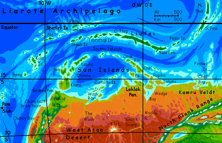
LIAROTE ISLANDS
This is another climatic world. The Liarote Archipelago has three extensive, roughly parallel island arcs or chains running 6000 km from the Psais in the east to Reng in the west... and north right to the equator. Much pleasanter than the mainland, and far more fertile. Two chains, the Suns close offshore and the Rainies near the equator, are bigger than the Antilles (Cuba, Hispaniola etc) though not quite Indonesian (or maybe they are: the biggest island, Liufai, is fully twice the size of Java).
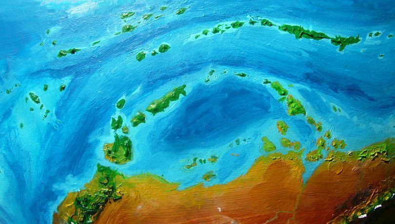
The Liarotes have more biomass--and inhabitants--than all the north shore and desert; nearly as many as all west Ata's mainland. Diverse, too--from raw, cliffy, arid giants like Lulumu and Rupika through the grassy bluffs of Ksaru to the pleasant groves and savanna of gentle Kosira to the monsoon woods of Liufai or the Kulas, to the rainforest of the Shetiris. Lovely beaches everywhere...
I'm almost convincing me to pack up and move, before the land rush. After all, now (at long last) it's possible to go there--I finally wrote a full tour for the Liarote Archipelago. Mere years after the others!
NORTHWEST
The west coast is diverse. Like Chile or America's left coast...
In the far northwest: the Grakse Peninsula is an isolated Oz, relatively green, cut off by the western desert. Monsoon woods and savanna. Like far Northern Australia, but twice as big. More akin ecologically (and culturally, I bet) to the Liarote Isles to the north than to the rest of Ata.
The north-central coast: as we head south into Chura Gulf, the shore grows scrubby, then arid--an Angeleno strip with trees only in the hills and along streamcourses.
At least the creeks here rarely fail entirely--they're snowfed. Without high mountains, the inland desert would run right to the sea. As it is, the rainier highlands form a north-south bridge for life between the tropics and the habitable temperate strip to the south.
Brick Point is a rarity: named for its color. One of the few Kakalean names new enough to still have a translatable meaning; most such are found in the deserts or arctic, where names were bestowed by mariners or relatively recent settlers; elsewhere, deep-rooted locals have worn the names down to euphonious meaninglessness, like wind-smoothed desert hoodoos. Brick Point's translatability tells you how many people live here: none.
Beyond the Point lies a thousand km or more of straight desert coast, livable only at creekmouths. Like Baja California with the mountains way inland and no coastal hills... just dry dreary plains.
After that, the central coast is a surprise: still with a long dry season, but getting mild winter rains--North Africa? Coastal hills and impressive bluffs; open woods and meadows.

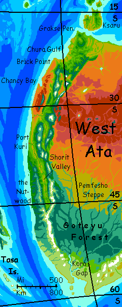
SHORIT and PORT KURI
There's even a quite Californian central valley, Shorit Valley, over a thousand kilometers long--savanna and riverine woods below densely forested mountains. At least the lower, hotter half of Shorit Valley looks Californian; but its upper stretch is further south as well as higher elevation, so is notably cooler and more wooded: like Oregon's Willamette Valley. Or slipping from Spain into France...
Upper or lower, Shorit's climate is friendlier to animal life than either the dry north or the misty treeish far south--hot dry summers, but perennial snowmelt streams for drinking water, irrigation and cooling off in. I'd expect fairly dense populations, food surpluses (storage is easy in the dry climate), and lots of leisure time. High culture? Oh, and trade...
At the mouth of the Shorit River is a great city, Port Kuri. From its ninety docks, deepwater tradeships sail west over the passage to the fertile Tasa Isles (on the curving horizon in orbital photo), blessed by being... not in Ata! A rare desertless region of Kakalea. It's only a two- or three-day run on a fast catamaran across to Great Tasa; more London to Paris than London to New York.
So these two population centers are increasingly linked culturally. Shoritians don't think of themselves at Atan at all. And why should they? Their region's an ecological island. They'll look west--to Tasa, yes, but on to Suma, Tua and Kera... Shorit's the east end of a long band of fertile shore-strips extending most of the way round the world--indeed, it'd be a ring if southern Ata weren't in the way! Two of the three worst ship-passages of the southern hemisphere are here--Cape Koro, due south of us, and The Tongue 2500 km east of it, each as rough as Cape Horn and even closer to the Pole, and with a long cold coast between--nearly Siberian, and unbearably harsh to heat-adapted Kakaleans.
This long arc or interrupted ring is by far the largest integrated trading zone on Kakalea. So it's logical Shoritians look, sail and identify west not east. My insistence on touring "continents", as if this Terran concept was objective and applicable, is getting me into trouble here! The Kakalean world is made of coasts--and the tradelinks between.
The mountains around Shorit Valley are, like California's, good places for observatories. The largest telescope on the planet--a one-meter reflector--is here. It's no fluke; the second largest is here too. Science in general is culturally valued here; Port Kuri's university is perhaps the world leader in math and science.
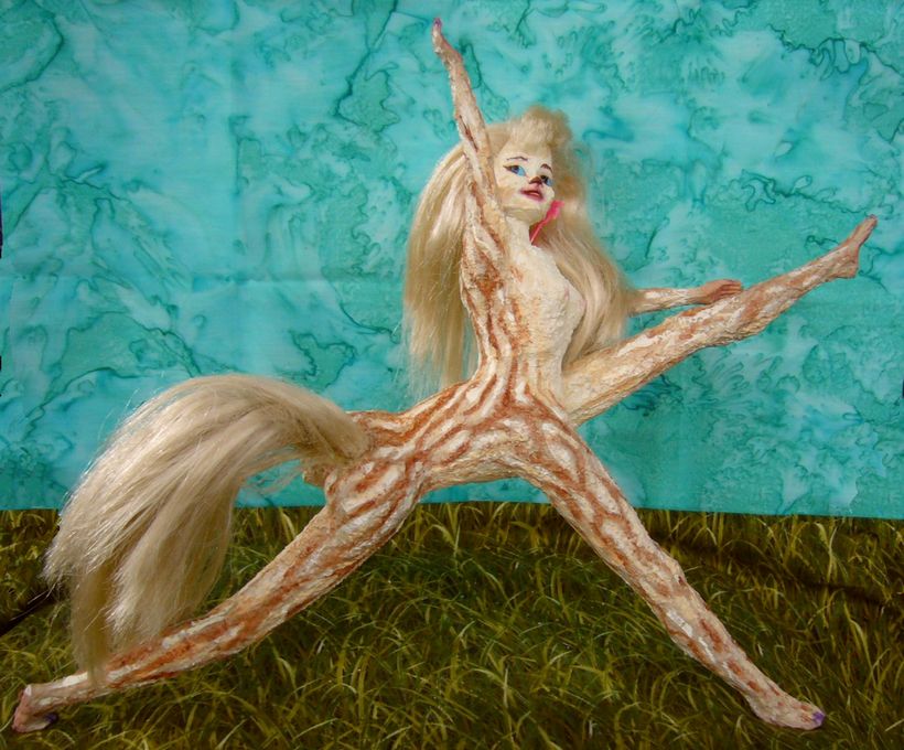
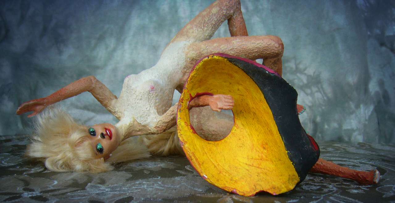
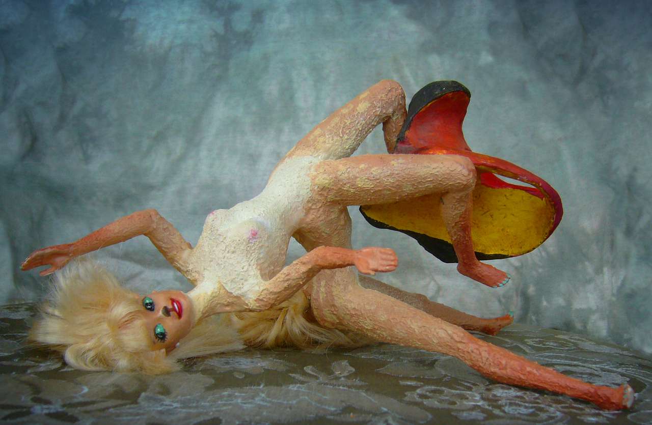
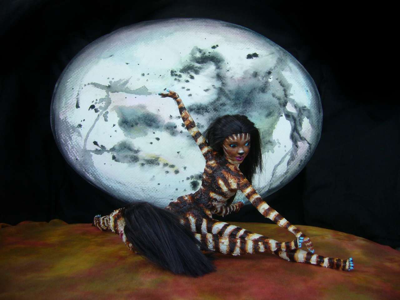
It's visible even in the arts. Here's Storia dancing the tale of her mathematical passion:

|
|
|
| ||

|

|
|
| Storia dances her composition The Manifold: a Matherotical Ballet in Port Kuri | ||
As you can see, Kakaleans entirely lack the silly human bias "girls can't do math and science"; but then, they entirely lack the idea there's any opposition between reason and emotion, or even, as here, between abstract mathematical elegance and lust. Storia finds her newly-discovered mathematical manifold so hot she just has to mate with it, but that's not the ballet's plot. It's all about the nuances, not the mere fact that math turns you on... that's a given. On Kakalea, girls (and boys) really do science...
Sad about that rainy planet with those bald bipeds. Curious coincidence, their simultaneous sexual and scientific repressions. Oh, wait, they rise from the same patriarchal dogmas...
NUTS
Let's sail on south. A mountainous shore, cloudier than Port Kuri; fog but little rain in summer. Soon it's a forest of giant trees, topping 60 meters (around 200')--impressive in Kakalea's higher gravity. Like Antipodean redwoods! Though these have small berries and edible if strong-tasting nuts. Why not? Yews have berries; plenty of pines have tasty seeds. So this nutwood (called, logically, the Nutwood) feeds a whole ecosystem up in the canopy.
For a while I had hopes the natives could get up there--and more importantly, get back down slowly, not quickly and painfully. If they could feed themselves on that productive canopy, the population here would be high and the civilization interesting. But these huge vertical trees, with few limbs below the waist, aren't easy to climb. Exploiting them safely takes flight; and Kakalean air is thin and the gravity high. Birds here are smaller than their Terran counterparts.
I could, and have, managed to evolve Goat Barbie and Sea-Serpent Barbie, but not Giant Raven Barbie or Parrot Barbie. The air's just too thin to get them off the ground. Parakeet or Crow or Flying-Squirrel Barbie, sure... but nothing big and brainy enough to build a civilization. The dominant centauroids are great runners and decent acrobats, but only a little better than humans at climbing trees--and these trees are formidable.
So I fear this rich forest canopy will be wasted on cat- or crow-sized beasties who can scamper around up there and survive the occasional long fall--or glide away. The cube/square law just won't allow bigger ones to flourish.
Looks like this long, fertile shore will be a mere cool hinterland to Shorit and Port Kuri in the north--just a string of modest port towns milling and exporting pest-resistant lumber.
Well, maybe a minor sideline in nuts--harvested by suicidal centaurs using long rope ladders, nets, hooks and poles. Nuts who pick nuts.
Oh, well.
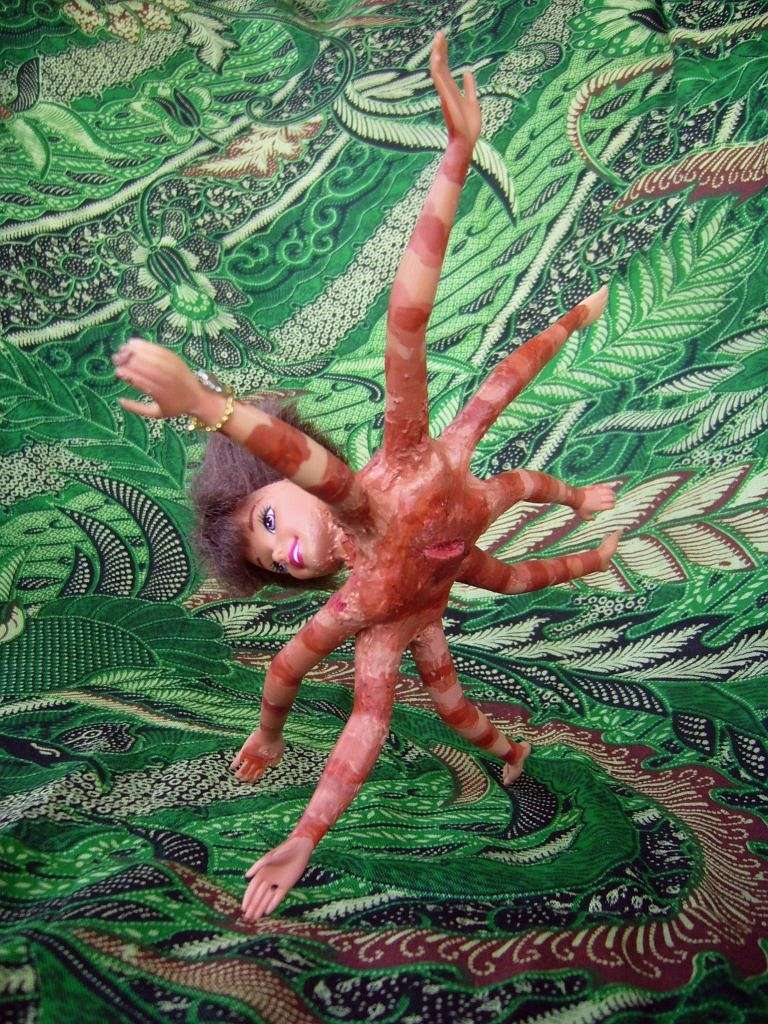
But maybe there is hope. On the far side of the world, on a tropical archipelago called Biariti, a place as isolated and strange as our Galapagos, weird little Octopians swing in the trees. Think "Octopus-Spidermonkey Barbie" (better, don't think it. Oh. Too late). They look pretty dysfunctional to me, but looks are deceiving. Eventually, some catamaran crews will have the insight to hire some of these funny-looking little folks for rigging work. They're not big or strong, but they can survive falls that'd kill a centaur or a human. And they don't fall. Eventually, octopoid sailors will be routine all over the tropics.
Later still--millennia perhaps, but at some point in deep time it will happen--Darwin has spoken!--an Octopian sailor, stuck on a cold, miserable voyage (the temperate zone, of all forsaken places. Who lives in the temperate zone?), will jump ship and get stuck in a gloomy port town in the shadow of the Nutwood. Out of sheer boredom our sailor will climb a giant just to get some sun. She notices the crowns bear nuts, and symbiotic berry bushes grow all over (their debris creates a moist sponge saving the big trees the trouble of pulling all their water up from that gloomy floor--this happens with redwoods too). Food orgy! Warm and well-fed, she'll shout "Eureka!" and come down to write home--spreading the gospel about the true Octopia.
The Nutwood may end up a gigantic Octopian orchard, its trees seen not as lumber but aerial farms. This says something about nuts, or vision, or nuts with vision, but I'm not sure what. Patience, maybe.
So "Oh, well", for now--the long now--but not forever.
Past the Nutwood, in the far south, are dense misty woods below glacier-mantled volcanoes. These mountains form not a rainshadow but a droughtshadow: the desiccating blast of katabatic winds off Sia's icecap can't reach this coastal strip. Storms blow instead from the northwest, off the ocean, from a latitude bringing constant precipitation. Winters are sunless and gray--rain, sleet and fog. Summers are mild but still wet and cloudy (if they happen at all). A bearded, mossy, boggy strip friendlier to plants than animals.
Still, it's fertile; on Kakalea, that's a lot. And no one needs or tries to fight the woods back and farm; they live on the shore or along rivers, eating salmon-equivalents, psuedoclams, sea vegs, and berries by the hectare. An easy life--just don't lose your way in the woods. Or forget your bark rainhat. By the time you remember and return, it'll have mossed over and turned into the dreaded Moldhat.
Tales of what this sinister creature does to your your brain (hint: slurp!) are how Kakalean babysitters scare colts who've asked for it.
THE SOUTH: STEPPES AND TAIGA
At the far southern tip of the continent is the Koro Gap, between the western and southern coastal ranges. Here the polar wind-blast penetrates well inland, keeping the coast treeless. A rare inversion of the usual Kakalean wooded coastal strip; in the Gap, the lower reaches of the Koro and lesser rivers are treeless "tundra", yet inland is a thin Siberian forest. For once, being on the back side of the mountains is a virtue!
Antarctic winds hammer the far southern coast too, east of the Gap. Relentless. Over 2000 km of cold boggy grassland--no permafrost so we can't call it tundra, but a harsh treeless country, frozen half the year. Caribou/reindeer and their attendant predators, very like Terran wolves.
Well, they're reintaurs or caritaurs, with a short thorax (foretorso) leaning forward and long arms so their hands--opposable thumbs, can't call them mere forepaws--can grub around under snow, foraging for dead grass and lichen, leaving their heads free to keep an eye out for wolftaurs.
Wolftaurs who are, just like Terran wolves, as smart as chimps--brains as big as a human child's. But fortunately for their prey, the wolftaurs got caught, several million years back, in an evolutionary cul-de-sac: their small forehands overspecialized, grew slashing claws. Deadly to a deer, but you have to catch it first. Scissorhands, Wolverine... or more to the point, sabertooth cat. Hard to back out of a genetic commitment...
I should have named this country the Sabertooth Taiga.
Had their hands stayed general-purpose, grooming and carrying, they might some day have graduated to throwing rocks, then boleros or spears, and started a spiral of tool-use and further brain growth... and by now this would be Wolf World.
Oh, well.
I'm glad it didn't happen. Brr, imagine a planet of touchy, bloody-minded predators all jostling to be alpha... oh wait. We live there.
Okay, I'm glad it didn't happen because then I'd have to make wolftaurs, and if you think it's hard finding Ken dolls in San Francisco, try finding Werewolf Barbie. Ski-Bunny Barbie, yes, and she'd be better adapted for this wretched snowy coast than my poor centauroids, but Wolf Barbie... no.
Behind these mountains, to the north, is... NOT DESERT! One of the few places on Kakalea that's true. Goteyu Wood is low and sparse, but still a forest belt some 1600 km long (1000 mi) and half as wide. The northern hem of this Siberian wedge frays into mixed woods and prairie, with harsh winters and hot summers. That Goteyu Wood eventually fails is no news; its mere existence is the Atan miracle.
North of this is an even wider wedge of dry grassy steppe, Pemfesho Steppe... cold in winter, hot in summer. Mongolia? Trekking north across Pemfesho (perfectly feasible; any local yurt will welcome you. People here are hungry for news.) the prairie slowly dries and fades into the inevitable inland desert, one of Kakalea's largest, nearly as big as our Sahara.
Oh, well. But a delayed oh, well.
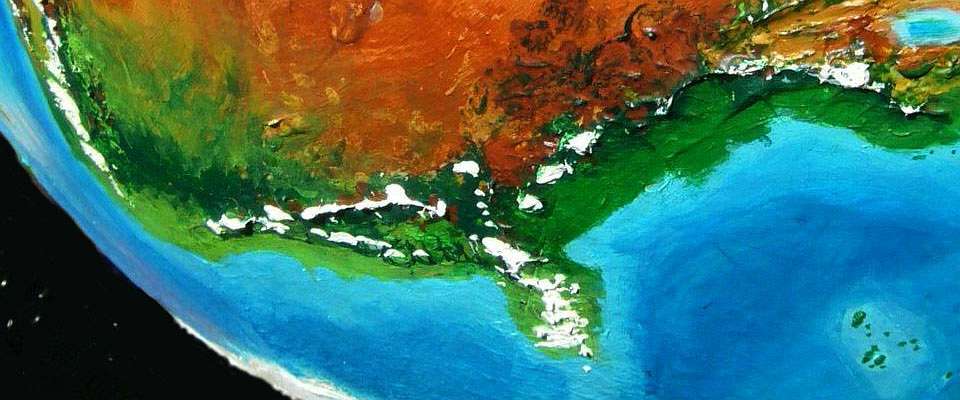
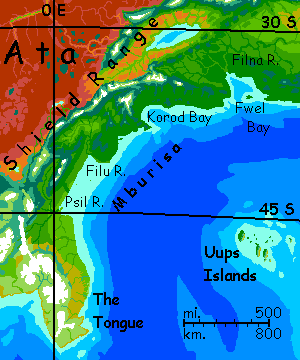
Back on the windblasted coast: the Tongue! A peninsula bigger than Korea. Dramatic, with glaciated mountains rising sharply from the sea. But the climate is harsh. In the south, blizzards from Sia's icecap batter the exposed, treeless shores. Not Korea or Norway--more like Alaska's North Slope. Pale greens, rusts, leopard-dappled in silver spots.
Or would be, if you can see it. Ships that MUST pass this dangerous cape stay well offshore, praying for a mere fairweather gale--as good as it gets--not a black storm whose winds force you straight onto the rocks.
Further north, round the tip of the Tongue, winters are still cold and the land's still treeless, but here the problem's that the winds shift round; they blow mostly from the local icefields--cold and (more important) dry. As in Patagonia, it's not the cold, it's the aridity. Your ship pulls in close--but there's little to see. A drygrass plain with ice-peaks on the distant horizon.
Two or three days farther east and north, as we finally escape the Tongue, the land greens. Cool prairie, with low trees along streams; fishing and herding villages at creekmouths. Blizzards in winter, but much milder winds, and real summers again.
A day later, wooded hills and a wide rivermouth--the Psil. With a real port. This is just the start of a long green coastal strip, called Mburisa, running 2000 km (1250 mi) northeast all the way to Fwel Bay. Busy little ports at each rivermouth, exporting lumber. And, most of the year, importing fruits and vegs from the subtropical north. Spring comes late here--summer gets hot and muggy, but the growing season's short, especially here in the south, up the Psil and in the Filu Valley.
Snowy sawtooth peaks hover on the north and west horizons, little reminders of winter.
The wooded hills turn golden then red early in fall, then drop their leaves, unlike most of Kakalea's forests. No surprise why. Leaves staying on trees get trashed in blizzards. Bad climate creates color...
Just as on Earth, this autumn display's seen as mysterious, magical and a little spooky. Mburisans lack a close equivalent of our Día de lost Muertos or Halloween, but everyone does celebrate the Harvest Moon. A little anxiously. As dark closes in...
This fertile shore between mountains and sea looks Edenic, but like so many Kakalean coasts Mburisa's narrow--just 240-400 km (150-250 mi). The back side of the Shield Range drops to desert--a maze of black barren lava fields and sinks. Summer temperatures can match Death Valley. The few people here live in old lava tubes and farm small gardens along the rare creeks. Spartan. Back to the Kakalean outback norm.
Oh, well.
Will Mburisa, the Shield Range and southeastern Ata eventually splinter off from Ata, forming a new mini-continent? I think it's likely. Once it happens and the mountains creep far enough offshore, the new south coast of Western Ata may be lower and opener to storm tracks, greening one of Kakalea's worst deserts! But not for sure, and not tomorrow. Check back in thirty million years.
Geographically, Mburisa is unquestionably West Atan, but like the Shorit Valley it's an ecological island; culturally it looks east, to the south coast of East Ata. But the East's another tour.
Eventually, this final paragraph will elegantly summarize your West Atan tour. A summation full of irony. Or least irony oxide. All that red dust! The stuff gets everywhere.
LISTS AND LINKS: More worlds? Planetocopia! - dreams of other worlds - ecology - climate change - evolution - natural disasters - terraforming - sculptures and 3D art -
World Dream Bank homepage - Art gallery - New stuff - Introductory sampler, best dreams, best art - On dreamwork - Books
Indexes: Subject - Author - Date - Names - Places - Art media/styles
Titles: A - B - C - D - E - F - G - H - IJ - KL - M - NO - PQ - R - Sa-Sk - Sl-Sz - T - UV - WXYZ
Email: wdreamb@yahoo.com - Catalog of art, books, CDs - Behind the Curtain: FAQs, bio, site map - Kindred sites