
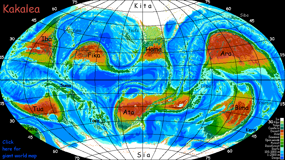
Kakalea:
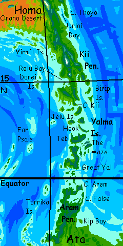
HOMA
under construction--west sketchy
by Chris Wayan, 2012-2014
for the forgotten Ice Age settlers of North America
Kakalea basics--map--geology--
creatures--
Building Kakalea
More worlds? Planetocopia!
Kakalea:
HOMA
under construction--west sketchy
by Chris Wayan, 2012-2014
for the forgotten Ice Age settlers of North America
Kakalea basics--map--geology--
creatures--
Building Kakalea
More worlds? Planetocopia!
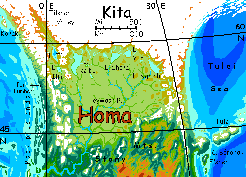
KITA VERSUS HOMA
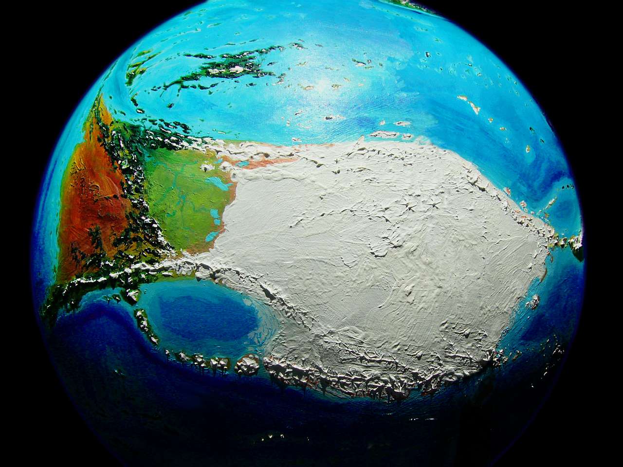
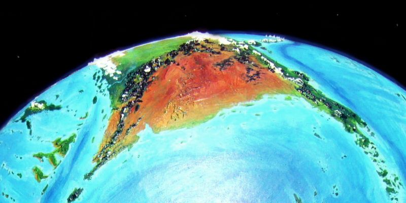
Kita-Homa is the biggest continent in the world--maybe. It's hard to tell. Kita, the northern half, is completely iced over, and the seas around it have weather nearly as bad as our Antarctic: not easy to explore. Not even easy to photograph from space--the polar high-orbital shot above had to be taken near midsummer, as Homa's deserts roast at high noon, and still parts of Kita are lit only by a low midnight sun. Some things are just too big to see clearly--and light properly. Siberians know what I'm talking about. How many time zones up there?
Kita's ice may exaggerate its size. The seas around Kita are much shallower than Earth's Arctic Ocean, so much of Kita's ice may lie on shallow seafloor, not land. When (not if) Kita drifts off the pole and thaws, it may turn out to be a mere Australia, not the Antarctica-on-steroids it seems now. But the ice, ephemeral as it is, is all we can measure, and by that standard Kita-Homa is huge: 35 million km2 (14M sq mi)--the same size as the sprawling desert continent of Ata, its only possible rival. More Asia-sized than African.
But only 15M km2 (6M sq mi) of Kita-Homa is ice-free. This southern subcontinent, Homa, is what we'll explore here.
Homa alone is nearly as big as South America, though far less fertile. It divides neatly into northern and southern halves. Take your pick--tundra, or desert? (That's Kakalea. Oh, well.)
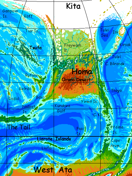
NORTH HOMA
We'll start in Shelter Bay, a small fishing port in the northeast, some days north of Cape Bóronak. This coast, the Tulei, is grassy, cold, windy, with stunted trees. But appreciate them; they're the last you'll be seeing for a while. We're going to trek across the continent below the ice.
Your road lies inland, over the Coast Range. Well, path; it's barely wide enough for a single wagon, and you don't see a single one. All the travelers passing you are on foot. They're passing you because Kakaleans are lightly built centauroids; their natural gait is faster than human hiking.
It's spring and you'll have to trudge through snow in the pass, but it's a safe, well-managed road for Kakalea. Cold isn't the main danger for you--it's altitude sickness. The pass is all of 1200 meters (4000'). Doesn't sound so high, but Kakalea's air is thin and a bit oxygen-poor to start with, and thins faster with altitude--high gravity holds the atmosphere tight. Oxygen in the pass is like Earth around 5500 m (18,000'). Expect exhaustion, headaches, insomnia and (most important) bad judgment. Listen to the locals. Their brains work.
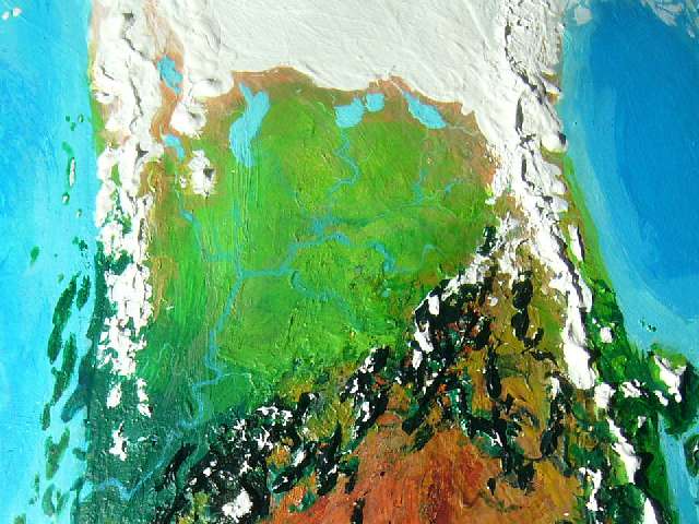
The pass doesn't just have you in a mental haze; you seem to be walking through time. From a New England fishing village in the time of Thoreau and Dickinson (okay, with centaurs, but still clearly civilized) back to the Pleistocene! Looking west from Last Pass, all you see is endless pale prairie with hulking creatures grazing in stiff, relentless wind, cold even now in spring. Dry cold air off the ice! Though it lies in our cool-temperate zone, from 40-58° north, the proximity of the ice makes this tundra seem Siberian most of the year.
Well, one word of that was false: this prairie is not true tundra, that is, permanently frozen ground with just a surface layer thawing out in summer. Such permafrost (hundreds of meters, in parts of Siberia) is a relic of our last Ice Ages; but Kakalea hasn't thawed out from a colder time. This is it--about as cold as Kakalea ever gets, and that's little colder than Earth today. Kita's ice has spread this far south only because it's a big, confident polar cap (ice breeds ice!) with broad lands to build up on. An opportunistic tongue!
In contrast, our seas pen in Antarctica and Greenland. Sea ice stays shallow! It's only an accident of geography that Earth lacks such ice-tongues today, reaching far from the poles down into temperate lands. If the Antarctic Cap had a landbridge to follow, it'd probably swallow Patagonia. While the Siberian and Canadian icesheets were huge, and had land to the south to spread to, their centers weren't far enough north to survive the interglacial warming; Greenland's, though much smaller, persisted because the north end of the island is truly polar. (Well, as I write this, it still is. Maybe not next week.)
So Homa's northern prairie isn't true tundra--just cold, wind-blasted and miserable by Terran standards. But to the megafauna that graze it (emphasis on mega; size helps keep you warm) it's not so bad. Plenty of food (if monotonous); predation and blizzards are their main worries. The year's cycle: a white plain, then a brown one, then green, then briefly gold, then white again. Mate a few times if you're lucky, then go back to eating. Grow a warm coat and dig up hay and lichen in the white; fatten up but get bug-bit in the green and gold. Repeat until death.
Not my idea of excitement, but it takes all kinds.
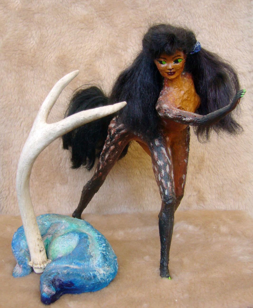
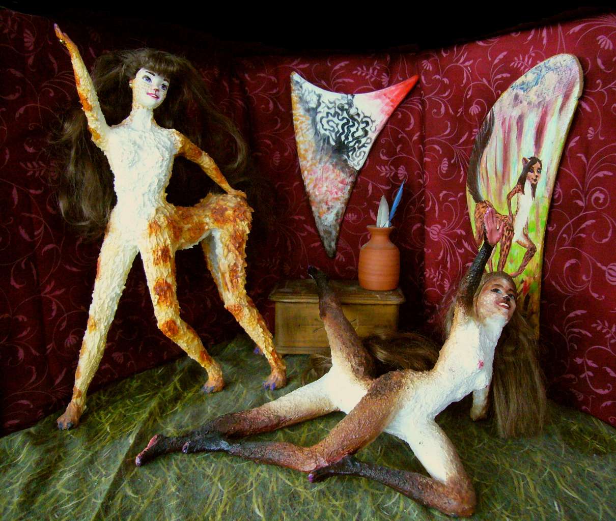
Frizia in her travelog-dance Tundra: Hornier than you Think |
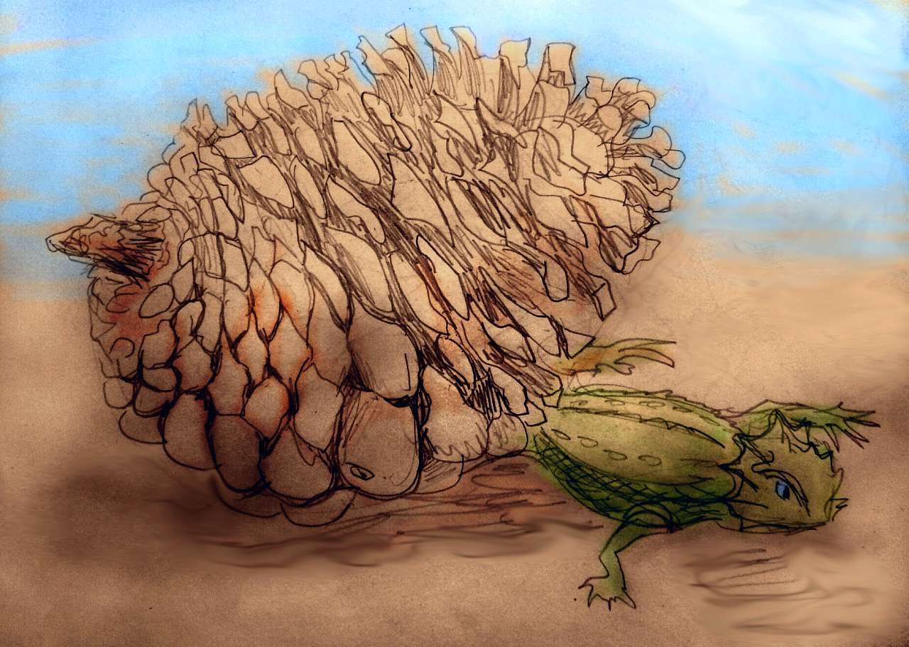
I don't have any sketches yet of the wildlife, but here's a Kakalean showing off a couple of finds that give you an idea how big the critters can get, up near Lake Yut at the foot of the ice. This girl, Frizia, is quite human-scale, about 160 cm tall (5'4"); so that antler off an oont is a good 1.4 m (4'8").
The twisted meter-long blue thing... well, that's a charming example of a local craft--an abstract sculpture made by molding a blue claylike substance ubiquitous on the tundra: mammoth poop. Well, grenla poop, but though a grenla is a centauroid too, like most Kakalean megafauna, one look and you'd say mammoth. Big, hairy, big, tusky, and big.
This isn't really the tundra, of course, as the furry backdrop shows, but a dramatic performance I saw months later, back in Port Bóronak on Homa's east coast where we started, after the whole trip was over. Frizia was touring the coast with a popular show-and-tell (well, dance-and-sing) of her travels around the North. Travel tales are more common than tragedies on the Kakalean stage; though romance and comedy are still more popular--Kakaleans aren't THAT alien. But you'll be seeing a disproportionate number of travel scenes in these pages, since geography and ecology are our proper focus here. I'd never stoop to cheap laughs or use nudity and sex to lure in audiences. No.
You spend the next few weeks steadily trekking (at Kakalean half-speed) across this steppe at the foot of the Kitan ice-tongue. You skirt the shores of a string of great lakes--Lake Ngalch, Lake Yut, Lake Chora, Lake Reibu...
Everywhere you go, you find campsites, but not many people. Folks here are nomadic, traveling in loops--north in summer, sheltering in canyons of the Stony Mountains in winter.
Funny, all the camps are up in the low hills, not down by the lakeshore. Inconvenient for fetching water, but prudent. Even when the far shore is over the horizon, the glaciers calving into them can kill you. When a truly huge berg falls, the whole lake can suffer a freshwater tsunami.
And now and then, up on the cap itself, an ice-dam bursts and a whole subglacial lake drains torrentially into the lake you see. Such floods can be catastrophic--on the scale of Old Mars! The lake can rise 50-100 meters, then pour downriver, scouring canyons bare for two thousand miles to the sea.
All the streams you cross are shallow, braided and shifting, for they're full of glacial silt and often clog their own channels and shift. They're all arms of one great river, the Freywash. Yep, all the catastrophes funnel down a single channel to the sea. Is that a good thing or a bad thing? Bad if you live in Port Freywash; good for everyone else, I guess.
NORTHWEST HOMA--or is it SOUTHWEST KITA?
Past Lake Reibu, we veer south to skirt the icemantled volcanoes on its western shore--the Tilnit Range--then north again to Lake Ilin, last of the Great Lakes--except for Lake Til, upstream, frozen most of the year, surrounded by icy heights. Save yourself the trouble--you face those right ahead. You have the West Coast Range to cross. Same hazard as crossing the mountains from Cape Tulei to the inland steppes--oxygen shortage. Go slower than the natives--one-third their speed is good--and keep your head.
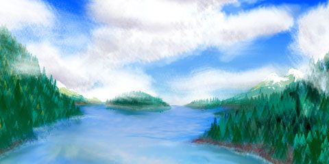
On the western slope, the winds off the ice cap are blocked. Another world! As you descend, forest grows dense, the trees huge--a true cool-temperate rainforest like our Alaska Panhandle.
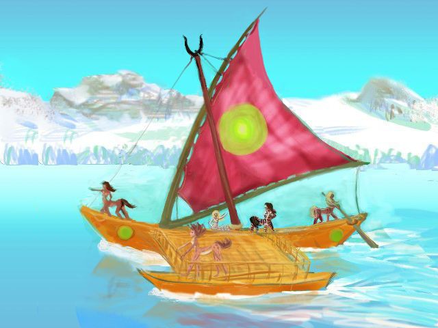
In Port Lumber (well, Port Lumiaberaha, but some wit shortened it long ago; and it is appropriate given the main export and all the carved... well, everything, including a fair number of the faces; lumberjacks live rough) you arrange passage on a trade catamaran heading northwest along the coast. Cats are the commonest rigs on Kakalea, even for cargo vessels; Kakalean cargoes other than wood or (rare) dressed stone are rarely heavy, and the centauroid crews are more comfortable out in the sun, wind and even rain than cooped up below decks--on these vessels, that's strictly cargo territory. Except in howling blizzards, you stay on deck. Bundle up or snuggle up. Kakaleans, evolved from herd animals, aren't as fussy about body contact as humans can be.
Here's a quick, crude sketch of your ship. Yes, you're sailing thousands of km on a boat this small. Kakaleans do this casually. It's not recklessness or primitive technology; they could build big Terran-style ships, and do for specialized purposes (like I said, lumber and stone); but Kakalean geography makes most voyages safe for rather small boats. The planet has less water; the oceans, though extensive, are rather shallow. Islands everywhere! Restocking and repairs are always near. If you're becalmed, at worst you'll have to paddle a few days to the nearest port--and that's easier if your boat is small. Since the sailing's safer--a whole world's essentially a big Mediterranean buzzing with coastal and island shipping, and has been since the stone age--the seas are all well-charted (well, except the poles). Even out of sight of land, you always know where it is--and it's near.
In short: my sketch is crude (I'm no mariner; damn ropes running everywhere!) but the boat's light catamaran build and small size are accurate. Outrigger, wishbone mast, steering oar. And a bone in her teeth! Even in a modest breeze this little boat can do ten knots--fifteen with a good wind. Not just easier than overland travel, faster, too--as fast as an Olympic runner on Earth. There's a reason Kakalean civilization (I heard you mutter "such as it is"!) is coastal.
So it only takes a few days' swift sailing north for the glaciers on the heights to grow and merge until they're a long narrow icefield. They're still a cut-off arm of the great sheet, just as in Ice Age America--the West Coast ice sheet often separated from the main one centered on Hudson Bay, leaving an ice-free corridor all the way from Montana to Alaska. Here, a similar long dry valley exists, the Tilkach Valley. But eventually, far north of Lake Til, Tilkach dead-ends and the coastal ice sheet merges with the main polar cap.
But even this partial separation has consequences: icy winds scream south down Tilkach to blast the steppes, but the winds rarely cross the coast range. It's milder here, as it was along the Pacific Coast during our Ice Age.
So, nourished by damp sea-winds, forests hug this shore, at least at first. To the south it's like Puget Sound or the Inland Passage--the Psokip Islands shelter the coast and widen this maritime forest. Two of the Psokips are bigger than Vancouver Island. Fishing towns all over. But north of Port Lumber, the coast is straight and exposed. Within days (but that's over a thousand km north; 15-20 km an hour adds up fast), the trees dwindle and so do the villages. Though they do have the distinction of being nearly the only people on Kakalea to call themselves Kitans--a further sign, if you needed one beside their bare gray stone huts (after the grand longhouses to the south, intricately carved and painted) or the relentless raw wind, that it's time to go south again.
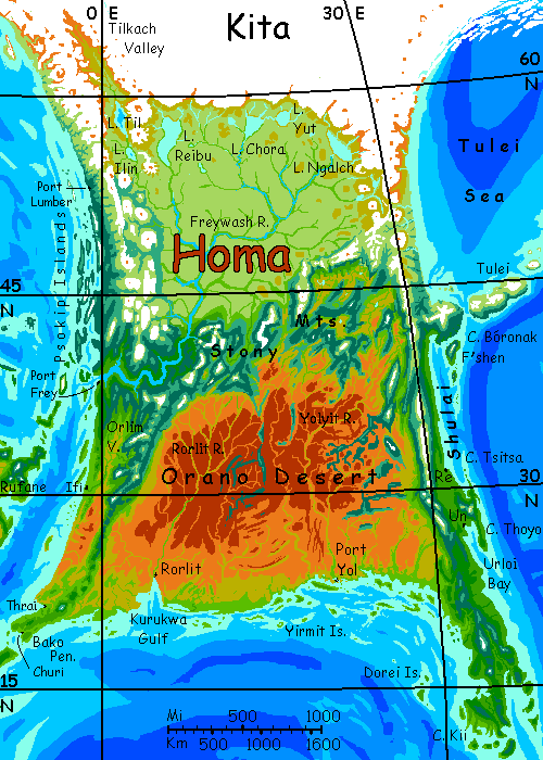
CENTRAL HOMA
The central Stony Mountains block those cold dry winds from Kita. Unfortunately, the eastern Coast Range is 2-3 times the height of North America's Appalachians--it blocks the warmer, wetter winds that would make the plains south of the Stonies something like the American Prairies. And central Homa extends further south, into a dry belt--instead of the rain-generating Gulf of Mexico, the dry flats of the Orano Desert.
The southern shore does get some rain in summer--inconsistently--but storms just don't roll far inland. While air masses from north and south, cold and hot, do clash in central Homa, the Stony Mountains get the brunt of this, unlike Prairie weather, where fronts wander hundreds or thousands of miles, spreading chaos and destruction but also life-giving rain. But in central Homa, the border is fixed and relatively narrow: the mountains.
What's the range like? Harsh winds and avalanches stunt or clear forests on many north slopes--they're not idly called the Stony Mountains. But wind-sheltered valleys have the only real woods between the east and west coasts. The southern slopes, facing the sun, have more woods, and some valleys here, especially to the west, are quite pleasant--true oases between tundra and desert. Well-settled and farmed, if isolated. The mountains of Central Asia, not the Rockies, are perhaps our best analogy. Culturally, too. These valley villages are little-known, unchanging, forgotten by the Kakalean mainstream.
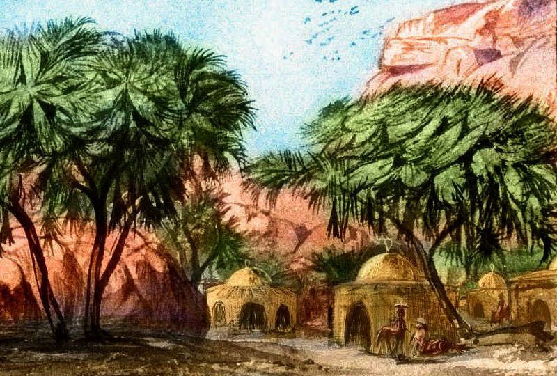
Why "especially to the west"? There, all the valleys drain south into the Rorlit River. Wooded streams, clean water, small towns with irrigated gardens and orchards. But the east end of the Stonies, north of the Yolyit River, fray into basin-and-range country with internal drainage and small lakes--brackish or alkaline. Their shores are mostly bare; winds kick up toxic dust. Same climate, same soils, yet relatively barren--and sparsely populated. Just a few canyons shelter small towns. Geography matters.
Still, even the eastern spurs of the Stonies, above the alkali flats, hold plenty of life. Forests may be sparse, but these aren't the barren crags of, say, central Ara or West Ata. Homa's outback is gentle compared to many on Kakalea; its sweep east to west is small (no room for a Sahara), the cold winds from the northern ice may be dry but they do generate storms, and the Stonies are about the highest of all the outback ranges. Bima's Tsenla and K'sei Ranges are their only real rivals, and they too have open forest on their shoulders, and high up, even alpine meadows and streams.

EAST COAST
Here we're on more fertile ground!
In the far northeast is a small sea, sheltered, if you can call it that, by the Tulei Islands, an arc of volcanoes quite like the Kurils on Earth--though Tulei proper, the southernmost, is as big as the lesser isles of Japan. Earth has a close analog: the Sea of Okhotsk. The Tuleis are windy, with harsh winters--that wind often comes off the ice sheet to the northwest. The Tulei Sea's northern shore is a small ice sheet and its surrounding mountains are glacier-mantled--except of course when they erupt and send catastrophic floods of steaming mud in alluvial fans to the sea. The central coasts and islands have much more open ground and some grass, bogs and even low trees. But overall, it's sparse country--more coastal Greenland than Iceland.
The southern lowlands, on the Isle of Tulei proper, are still too windy for more than low trees in sheltered watercourses, but they're grassy, supporting great herds of grazers--and herders protecting and milking them. Snowcheese is a thing. A strong-flavored thing. As the slogan says, "You can taste the silt." Kakaleans like food that bites back.
From Cape Bóronak (a Taiwan-size peninsula) on south, great forests rise. Humans would find this strip, called Shulai, quite habitable--tough humans at least. New England? Korea? Long cold winters, late springs, muggy summers, gorgeous falls as the leaves turn gold and red.

Shya walking through The Blush of Time as staged in the City of Re |
Yes, fall colors are an interplanetary phenomenon--wherever seasons are very strong. It's ergonomically cheaper to grow new leaves annually than grow ones tough enough to survive winter storms like these, roaring off Kita's ice cap. Though the northern Shulai coast is partly sheltered by Tulei, F'shen and lesser islands.
Here's Shya of Shirafia, getting prompted by reds and yellow that the season's changing and time waits for no one. A cultural message applied, in the play, about love and risk; but it could well be applied generally to the industrious people of this region. Like the Yankees, they're highly aware of time and mortality. How much of that is climate? A big red flag says "Winter's coming."
So Shulai/New England is green, or at least green then yellow, red, and white. But this fertile, colorful strip is quite narrow--just 50-100 km--and those aren't the Appalachians inland! The snowmantled Coast Range has horns up 4500 meters high (14,800'); this wall cuts off rain to the prairies.
Oh, well.
On the other hand, these mountains are why the coast is habitable at all. In our Antarctic, with an ice sheet smaller than Kita's, this latitude is cold and windblasted year-round. But that's because our Antarctic winds (and sea currents) swirl round the pole unimpeded--a barrier keeping Antarctica in a deep-freeze. But the high mountains of Homa (and to a lesser extent Iba, on the far side of the hemisphere) run right across these winds and currents, forcing winds, like currents, into great loops distributing the heat (and cold), moderating extremes. Especially here at the mountains' sheltering feet, the winds abate much of the year, and a warm current like our Gulf Stream runs north up Homa's east coast and along the islands. Without Homa's mountainous barriers, trees could never grow just 1000 km from the great ice.
Central Shulai is more exposed to storms, but by now the latitude is in the thirties; yes, Homa's colder than North America, but that's still a long, LONG way from the pole. The coast could almost be Virginia or the Carolinas. Along this stretch the big worry is summer hurricanes not winter blizzards--except in the mountains of course; they continue to be Alpine not Appalachian. But that's not latitude, but sheer altitude!
Still further south, from Cape Tsitsa to Cape Thoyo, an 800-kilometer stretch, a wide plain, the Thei Valley, lies sheltered between the Thoyo Mountains and the lower Coast Range. This plain is wide, warm and extremely fertile--eastern Homa's heartland.
It's densely populated. Re and Un (rhyming with noon, not nun) are two of the continent's largest cities, deserving paragraphs, at least. And sketches.
Eventually you may get some indoor theater scenes here too, for a change. Well, they're all indoors really of course, but they depict, in that inimitable Kakalean blend of poetic and dorky, outdoor scenes. Gives you the impression Kakalean culture's all rural geekiness and nature-dance. Not at all! But staging takes time. And of course my thesis is that geography and climate come first--the strata that culture builds on. Build the land before the house. Or house falls down.
SOUTHEAST HOMA
Southeast Homa is more mountainous and thus less populated than Thei Plain, but it's equally lush--a great peninsula getting rains from both east and west. Cape Kii is no more Floridian than the mountains were Appalachian--not unless Florida were inflated ten times and pimpled with tropical volcanoes, which trail 2000 km south to the continent of Ata as a chain of large islands, the Yalmas.
This peninsula is quite Malaysian. Dense, dark rainforests cover these mountainflanks and short rivervalleys. Trees grow 60-70 m high (over 200'). Huge leaves--not just because the jungle is wind-sheltered. Kakalea's thinner air allows larger leaves in general--less risk of wind-damage.
Such rainforest is a rare thing on Kakalea, where little land happens to lie in the equatorial rainbelt. At the moment, of course; chance will create an Amazonia (here or elsewhere) within 100 million years. Or rather, re-create it! Such rainforests have grown before and they will again. Kakalea's just having a bad eon.
Here nearly all transport is by boat; roads get overgrown, and the country's full of navigable streams. The people have a reputation for being languid and sensual. I'd say sensible! In the humid heat, you want to move slowly, steadily. Sweat won't cool you. Ride the current.
After we round Cape Kii, it's still jungle and islands for days, almost due north across the mouth of Rolu Bay, along the shore of Kii Peninsula. By the time you start threading between the mainland and the Yirmit Islands, though, the rich forests of Kii slowly break up as the monsoon rains grow shorter and less reliable. It's gradual over a couple of days, as you veer northwest, but relentless: the woods open up (a relief at first), then break into groves and meadows, then brush and tree-dotted grasslands, then treeless dry grass plains, then red desert.
The North American analogy breaks down here, as we're far south of, say, Alabama, and these "Appalachians" are so high they block rain. India's west coast, from lush Kerala up to the Thar Desert, may be a better analogy.
Except the scrub and desert aren't as unbroken; the high Coast Range still tempers all! Snowfed streams still seek the sea--linear oases. Too small to scour deep harbors--little ports at most. But these sunny creek-valleys, with gardens irrigated by reliable snowmelt, aren't bad places to live.
Don't worry. This is Kakalea. Have faith. Bad places will come.
SOUTH COAST AND THE ORANO DESERT
The less said about Homa's south coastline the better. Sneaky land. For years, regular summer rains lure you into farming or herding well inland, in the dry grasslands, and then floods alternate with droughts until the land reverts to desert for a generation. The only large towns huddle at the mouths of the (very few) rivers crossing the Orano Desert from the Stony Mountains--snowfed, they don't rely on these fickle monsoon rains.
The same goes for navigation--treacherous. Offshore, shallows extend for hundreds of km, and those floods and droughts make the rivers--such as they are--silty and muddy. New bars and banks appear every rainy season. Wise mariners stand well off, sailing straight from Cape Kii in the southeast to the Bako Peninsula in the southwest, not landing at the muddy little delta ports between unless they must.
Even most local traders island-hop through the Dorei and Yirmit and Kurukwa Isles, skipping the mainland.
The exception: dealers in gems and metals. Port Yol is an outlet for the mines of the eastern Orano Desert and Stony Mountains; the snowfed Yolyit River is navigable by flatboats year-round--if the pilots are good. Easier than carting heavy ore over land routes. Why not smelt it at the mines? They can't; not enough wood inland for furnaces.
So Yol gets the job. An unpleasant town--smoky, stripped of trees, with an arc of barren tailing-hills like sloppy Pyramids looming over town--a legacy of garbage not of gods.
Oh, well.
Rorlit, at the head of Kurukwa Gulf and the mouth of the Rorlit River, isn't as bad. Less mining, more farming. The Rorlit Valley is like a lesser Nile; a narrow strip of irrigated farmland. The town's famous for basketry and beadwork--lots of fiber, if not timber. Hot-weather crops do well. Peppers, melons.
Nice melons still don't justify a side trip. Notice that even Storia played this role on Dorei, not on the mainland. She couldn't be convinced to visit. Too hot.
WEST HOMA
Not all as fertile as the east--but with very diverse climates. And cultures.
The southwest Bako Peninsula, like the southeast, extends back down into the tropical rainbelt, though not as greenly, not as far as Cape Kii. It's monsoon country, with mild dry winters and generous if somewhat inconsistent summer rains. Oh, well. But not a big "oh, well." It's green, at least, unlike the south coast. Well populated--ports like Churi and Thrai, while not huge cities like Re or Un, are surprisingly cosmopolitan.
The Naliset Islands off Bako's tip are greener--quite Caribbean. The Nalisets run not south across the equator like the Yalmas but more or less east-west, like a string of Cubas, to the huge, rainforested Ayma Peninsula of eastern Fika--Kakalea's version of Central America. But with half a dozen broad straits, not a man-made canal. Unlike the mudbanks and siltbars off South Homa, the Nalisets are coral waters. Tricky, but at least clear, and not changing by the season. It's a busy shipping lane between the two continents. The interchange isn't just economic but cultural; that's why Thrai and Churi have flourished despite their modest hinterlands and limited resources. Bako Peninsula is small, but in the know. Hence that old Southern greeting, "So what's the news from Bako?"
As we sail north from Cape Bako up Homa's west coast, the rains fail even on the shore--except in summer. Sometimes. However, the mountains wall off the true desert and wring rain from what storms there are; though the shore is dry, these heights are wooded. This bridge of green, like the Sierra Madre Occidental and the Sierra Nevada, form a fertile north-south bridge across the western deserts for life of all kinds. Without the mountains we'd see unbroken desert to the western shore, as in Australia or the Sahara at the same latitude.
As we sail north, the coast starts to green a bit. Oak woodlands and grassy hills. Light winter rains, warm dry summers with fog on the coast. A Californian strip! The highest mountains are some 200 km inland here, and between the mild coast and the mountains is Orlim Valley, semi-arid but winding with snowmelt streams. Hot summers, but ideal for irrigation. A wealthy region! At the mouth of the Orlim River rises the port city of Ifi, the largest on the continent.
Orlim's a California with a proper Ecotopia to back it up, too. As we sail on up the coast, the woods grow dense, the trees huge. This great forest, a true temperate rainforest, is still only a couple of hundred km wide; mountains, steppes and deserts lie inland. But it is here. And exports huge, straight, decay-resistant lumber to southern Homa and even northern Ata (where large trees are rare).
You'll notice Port Frey, at the mouth of the great silty river draining the steppe and the foot of the icesheet, is surprisingly small. You'd expect more of a river that drains half a continent, but no one wants to live here. In the delta, huge lenticular islands betray a history of catastrophic floods. The edge of the ice sheet is stable in geological terms--a little retreat, a little advance--but the moraines and great lakes along its foot are not--a big enough avalanche at the edge of the ice, or if an icedam inside the sheet breaks, draining a lake no one can even see, then Lake Tilkach or Reibu or Chora or Ngalch could splash over a moraine and chew it to nothing in hours, fanning out over the tundra... then coiling and boiling through the coastal hills along the lower Freywash--the only possible outlet.
We haven't seen floods on this scale for eight thousand years or so, yet Indo-European languages and cultures still recall that time--the Great Flood, Noah's Flood, when the Black Sea finally connected to the Mediterranean and permanently drowned an area bigger than California.
Homa's floods, on average one a century, are briefer, scouring and drowning arms of the Freywash Basin only temporarily, but catastrophic nonetheless. Especially if you're downstream--rather than a tsunami's single great wave, this silty flood keeps on coming. Even the hills above the port proper aren't really safe. Marks 50, even 100 meters up slope attest to the scale of some of these floods.
So Port Frey's no London--not even a Portland--more of a dwarfed Ankh-Morpork. A town selecting for reckless, fatalistic people limits not only its size but its livability. Why clean up when it'll all be drowned anyway? Pulp mills, phew... you can smell Frey miles out.
Oh, well.
North of the Freywash delta, cool forests--a sort of Alaska Panhandle. Icy mountains not far inland, but green lowlands. A long stretch--the icefields grow more continuous but they're still a cut-off arm of the great sheet, just as in Ice Age America--the coastal ice sheet often separated from the main one centered on Hudson Bay, leaving an ice-free corridor all the way from Montana to Alaska. Here, a long dry valley does exist, the Tilkach Valley, but eventually it dead-ends in the massive icecap of Kita. The separation still has consequences: the dry winds scream south down the dry valley to blast the steppes, but they can't easily cross the high coast range.
So, nourished by damp sea-winds, tall, dense, dark forests smother the coastal hills and the long Psokip Islands offshore--two of them bigger than Vancouver Island. Small towns, sober fishers and foresters. This Inland Passage stretches some 2000 km.
And even once the coast grows grassy, then barren, then frozen, life clings to the long rugged islands further out--grass and even low trees. Seems unlikely, these forests near a great icecap! But even Ice Age Earth had a few. Location, location, location...
But the real interest in these seas is further out: to the southwest. Remember how shallow Kakalea's oceans are? Even modest seamounts can break the surface. Well, these aren't modest. The largest island, Tsufa, is bigger than New Guinea--more like Greenland stripped of its ice. And unlike that misnamed island, it really is green: one of the richest ecosystems on Kakalea. And its five hundred sisters range from Arctic to Caribbean, wet to dry--and from mere mountaintops to one giant the size of France.
Tired of Kakalean tundra and desert and "Oh, well"? Explore The Tsufa Isles.
LISTS AND LINKS: More worlds? Planetocopia! - dreams of other worlds - ecology - climate change - evolution - natural disasters - terraforming - sculptures and 3D art -
World Dream Bank homepage - Art gallery - New stuff - Introductory sampler, best dreams, best art - On dreamwork - Books
Indexes: Subject - Author - Date - Names - Places - Art media/styles
Titles: A - B - C - D - E - F - G - H - IJ - KL - M - NO - PQ - R - Sa-Sk - Sl-Sz - T - UV - WXYZ
Email: wdreamb@yahoo.com - Catalog of art, books, CDs - Behind the Curtain: FAQs, bio, site map - Kindred sites