
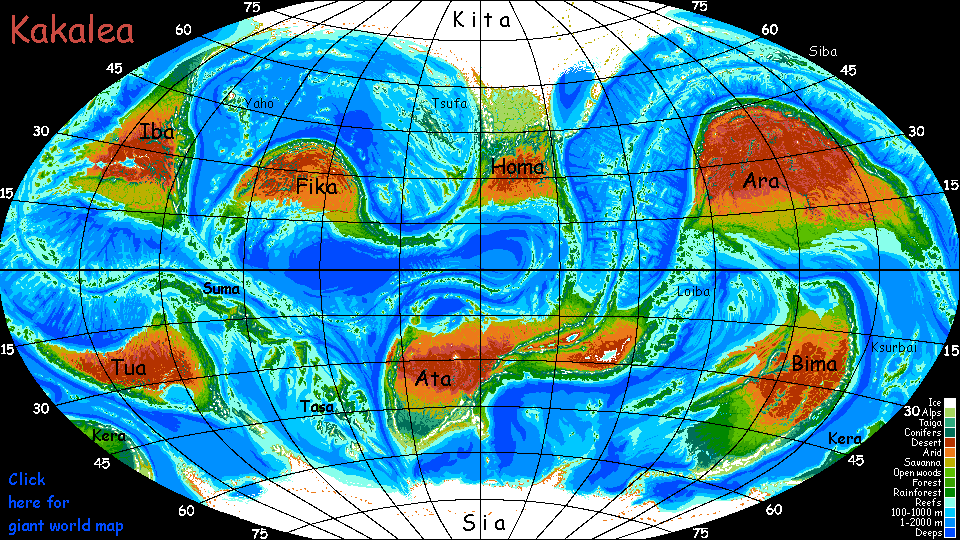
Kakalea:
IBARI ISLANDS
by Chris Wayan, 2015
Kakalea basics--map--geology--
creatures--
Building Kakalea
More worlds? Planetocopia!
Kakalea:
IBARI ISLANDS
by Chris Wayan, 2015
Kakalea basics--map--geology--
creatures--
Building Kakalea
More worlds? Planetocopia!
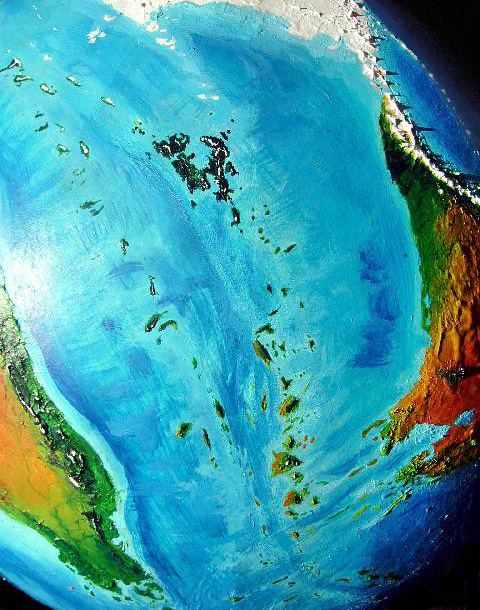
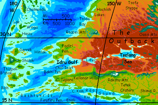
Off southwest Iba, Cape Teporo trails off into a maze of islands and sounds call the Reshtuki Archipelago. It runs a good 1600 km (1000 mi) southwest to an even larger mid-ocean archipelago, the Ibari Islands. In the south they're subtropical and semi-arid, influenced by Iba's desert upwind, like our Canary or Cabo Verde Islands. An outer or western chain parallels these; just as warm but greener. These are huge islands--Shalok alone is bigger than Ireland.
The Ibari Archipelago is both rugged and scenic. Its twin island chains are the flanking ridges of a mid-oceanic rift, where new crust rises. This spreading crust meets plenty of resistance from the stubborn continent of Iba to the east, pushing up jagged ridges punctuated by occasional volcanoes.
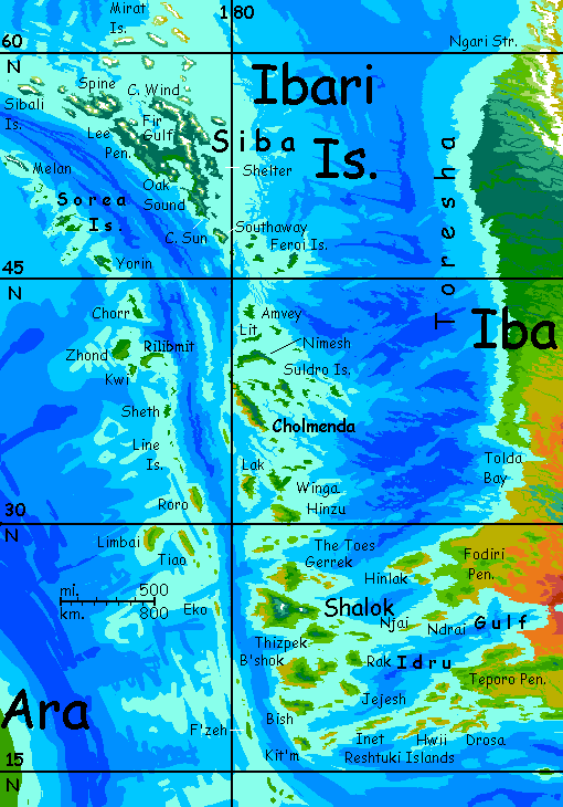
In the north, both the East and West Ibari chains run up through Mediterranean then European zones. The eastern chain culminates in a huge Nordic island I've described elsewhere: Siba, half as big as all Scandinavia (and as chilly).
South of the Ibaris, the mid-oceanic rift curves east but continues, roughly following the equator; its flanking ridges create twin island chains, the Ibatu and Twibba Islands. Warm, rainy, fertile but smaller than the Ibaris.
I plan to write a full tour here, but for now it's still brief in some stretches. If you want a fuller sense of what deepwater island chains of this sort are like, try the Artaho Islands--that tour's fleshed out. And the regions are somewhat similar.
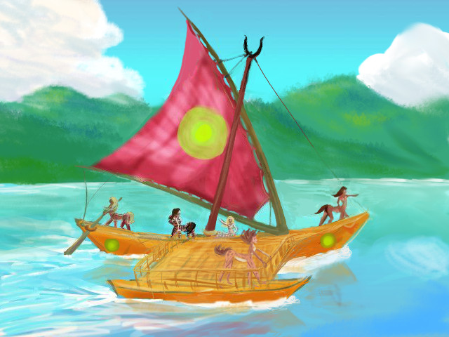
We start near the southwest tip of Iba: a peninsula called Firufiru. Like other Kakalean tours, we'll be riding a catamaran--the Pride of Cheirin is a traveling theater-boat, actually, performing a repertory of half a dozen new plays in small ports all over the archipelago. This is a common institution on Kakalea; a good way to disseminate news and ideas in general, since printing is costly.
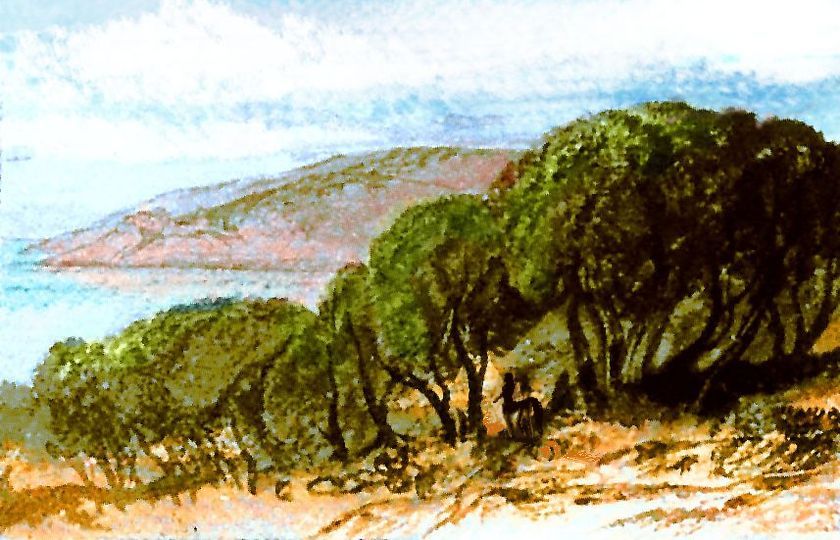
Our course veers west away from the rather dry Iban coast, along a chain of more pleasant islands, the Reshtukis. Rocky coves, grassy heads. Groves of oaklike trees and snakes of greener, aromatic broadwoods where small streams descend from long stony ridges with pasture between outcrops. A few patches of dark pinelike woods in hanging valleys. Downwind of a dry shore like southwest Iba's, most rains fall on the highlands. Gardens usually need irrigation.
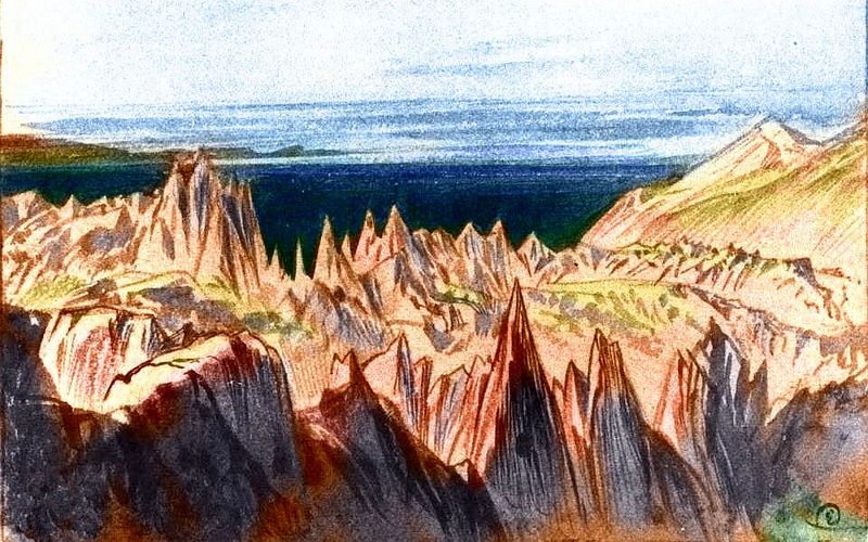
You'll notice that local houses are low and flimsy even by Kakalean standards; the climate's Mediterranean but the architecture isn't. Not even Polynesian. All this thatch isn't laziness, nor Subtropical Racist Subtext (how long must equatorial Barbies suffer?) but common sense. Quake-safety! You don't want stone arches or even heavy roofbeams over your head, not on these islands. The Reshtukis are notorious even for Kakalea--they're a fracture zone where the mid-oceanic rift curves; the segments north and south of the Reshtukis aren't just spreading at different rates, but colliding at an angle, inside the elbow. Each isle is its own splinter, jostling, heaping, corrugating. The zone is just too shattered to generate monster quakes, but constant midsize ones weaken and bring down stone and timbered structures--not on the first quake, but the twenty-seventh.
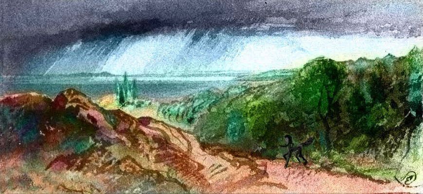
The locals also don't build homes down on the beach, tempting though that is in a zone of such gentle weather. No Southern California beach shacks! Shops, cafes, warehouses, yes; but not homes. Quake-generated tsunamis scour the coastal flats every generation or so, though waves over five meters are rare--the zone's too fractured.
Now you know what those modest stone pyramids are, with the boatlike prows toward the sea: not religious altars or military guard stations, but tsunami shelters. If you hear a conch shell hooting repeatedly, gallop like the locals.
Most of the Reshtuki population is on the inmost islands like Drosa; their mountains rise higher, supplying more reliable water. Many of the central islands (like Hwii, nearly as big as Drosa) are just too low to push air up high enough to generate rainclouds. Dry-grass hills, brush, scattered trees at most. Craggy seacliffs, but also rawboned rocks bursting out of the bare hills. Seasonal creeks; villages must rely on wells much of the year.
The southern Ibaris are much like the Reshtukis. Warm and sunny--in places, too sunny. West coasts of the more mountainous islands (and that's most of them) tend to be in rainshadows, and are dry to parched. The eastern, windward shore of each island gets enough rain for scrub and rocky meadows, with trees along watercourses. Irrigated fields do fine, and streams, while small, are generally reliable.
But not navigable. Most of the towns are along the coast; just scattered farms, pastures and mines inland.
On the larger islands, the highlands are high enough to be quite rainy and supply wood as well as tree-fruit.
Kit'm is geologically the last of the Reshtukis--it's in line with them, and clearly part of the fracture zone--but the first of the Ibaris culturally, since it rises after a gap with only low islands with little water. Kit'm is, in contrast, mountainous--ridges up to 1500 m (5000') and thus relatively green.
I suppose you could also say Kit'm is the last island in the Ibat Archipelago to the south, though no one here thinks so--that chain is equatorial, with a very different culture and biology--two intelligent species live there, ordinary Kakalean centauroids and an amphibious people called reefmaids. But that's another tour!
We head north instead. One day over shallow sea is our first unambiguously Ibaran island, Bish.
Next day, B'shok--and for the next week. For your theatrical troupe insists on circling nearly the entire island--east along the south coast, back west along the north. It's a huge two-lobed island, some 500 km long (300 mi); in area, as big as all the Reshtukis put together. Both lobes, east and west, have forested central mountains snagging plenty of rain. Reliable streams, well-off towns. Great Bay, on the north side, sandwiched between the highlands, is notably drier and (tellingly) the crew votes to skip it. They also ignore the west coast, also dry--the mountains of West B'shok rise to 2250 m (7400'), casting a rainshadow downwind. Not a desert shore, but dry savanna just a day's sail from gardens, orchards, pinewoods on the heights.
Around Shalok. We'll spend some time here. Two volcanoes rise so high they have near-perpetual snow: Cheirin to the east, a mere 3500 meters high (11,500'), a near-twin of Earth's Mt Etna, currently dormant but historically more active. Your boat is named for it; the core of your troupe is from this region. To the west rises the massive, greener, many-headed Soltin Knot, its highest peak over 4400 m (14,500') and glaciated on the north side; dormant some centuries but in some ways more hazardous. If any of the Soltin cones do wake up, huge mudflows may result. On the other hand, the steady release of snowmelt in summer and early fall makes Shalok's rivers navigable year-round; the interior's settled more densely than the other Ibaris. This, plus Shalok's sheer size, let the big island dominate the archipelago culturally and commercially.
While circling Shalok, your catamaran makes a two-day side trip around Thizpek to play on both sides of the island. It's a rather green island, without a dry coast; its central ridge is narrow and runs east-west, roughly in line with prevailing winds, so there are no rainshadows. The sunny south side is hotter and drier than the north, but still wooded for the most part.
Back to Shalok. Around East Point and along the fertile north shore to Gerrek Strait. Here your cat abandons Shalok--the west side is dry and less lucrative, like western B'shok. North to Gerrek!
Gerrek's bigger than Bish or Thizpek, a rough diamond some 200 km on a side (125 mi), but because its mountains are lower, less diverse ecologically and more prone to summer droughts. Here too your theatrical troupe sails up the southeast coast, then the northeast, skipping the dry west.
The Toes are next--a chain of islands lying across our course--probably marking a fracture zone like the Reshtukis. Small by Ibaran standards--the inhabited islands are 50-100 km across (30-60 mi), though long narrow Big Toe in the west is 160 km long (100 mi). All the Toes are low and fairly dry. But not as dry the lower Reshtukis! As we've sailed north, the shore of Iba has receded; winds here have crossed not hundreds but over a thousand kilometers of sea, rehumidifying the air. It takes less rise here to generate rain. So each isle's port may be small, but with good water. Coastside orchards and gardens rise to oak-wooded hills.
Hinzu is a geographic twin to Bish--a ragged wedge of green hills rainshadowing a dry west coast. But subtly greener all round--the highland woods descend closer to the shore, and even the dry western plain is a tree-dotted savanna with winding creeks.
North away! Distinctly greener. We're farther from the Iban mainland and its desert-influence, and we're heading into rainier latitudes. From Southern to Northern California, from Morocco to France...
The next isle really shows the difference. Winga is a rough V shape, and your ship sails slowly up the indented north side, stopping in several ports to play. Billowing clouds over the central ridges; forest right to the shore in spots. Orchards all over. Gardens look like clearings...
Lak, due west of Winga, looks more southern again. It's slightly rainshadowed by Winga's ridges, so it's back to the familiar pattern of Mediterranean lowlands, forested highlands, dry west coast--though your crew votes to run up it and do a performance because it makes better sense than retracing your course.
Cholmenda, 550 km long though generally just 90-100 wide (330 by 60 mi). It's as if Portugal or coastal California were cut off from the mainland and placed far out to sea. Cholmenda's west coast has pseudo-oaks and grasslands in the valleys, piny highlands above that see snow each winter. The snowmelt guarantees year-round streams, often navigable by flatboats, even in the driest valleys; so every valley has its port and prosperous farms run deep inland. The rainier eastern shore has broadleaf woods--almost Virginian. The climatic diversity allows both temperate and tropical agriculture, often in fields just a few miles apart. Topography isn't always destiny; but Cholmenda was dealt a strong hand. Wealthy towns.
Your ship runs up Cholmenda's west coast, down the (north)east about two-thirds of the way, then sets out to sea, northeast, tacking into the wind, to...
The Suldro Islands. Well, the western half--the four largest. Around South Isle, up the lee side of Suldro itself, then the north shore of Mid Isle, and the northern tip of West.
North of the Suldros, you bundle up. We're getting into the temperate zone now, and out of the shelter of the long island's mountain spine, the wind's a steady blast. Fast sailing, mild temperatures by the numbers, but a real wind-chill... though your crew's still all naked. Kakaleans rely on their fur unless it's freezing and even then only wear a sort of cloak or horse-blanket; fitted clothes confine them, make them itchy and nervous.
Nimesh, the other northern giant. Two climates, two cultures, but here it's not east and west but north and south. East along the sunny south shore. Warmer, opener valleys. Frost-free winters here, despite the latitude: the slopes face the sun, and the central ridges block storms from the north.
North away!
Lit, like a miniature Nimesh, 160 km long but only 25-40 wide (100 by 15-25 mi). On Lit you're never out of sight of the pale gray sea.
Amvey... Brr. Wind.
If we kept going north past Amvey, we'd end up in nordic Siba. But that's another tour...
Instead, here we sail west across the Rift, over deep water (a kilometer or two! Shallows, on Earth--but unusual for Kakalea) to the isles that form its other lip.
Literary anticlimax! What can be said that's new about the lesser chain? We've seen all this before on a larger scale! Oh woe!
THE NORTHERN CLUSTER
Amvey to Chorr... we'll ignore the Sorea Islands to the north--Yorin, Sorea, Melon... Chorr's cool enough. I don't want to go all Nordic. Brr. Pine-green, rugged. Fishing hamlets with cleared gardens, but otherwise the woods rise unbroken and somber to the ridgetops.
Around Zhond, largest in the Northwest--a couple of days. Cloudy skies, cool winds even now in summer. Habitable--the people are even wealthy--but they do look different--big and shaggy. You need to be. These people even occasionally wear clothes--only during blizzards, only out of doors, and only cloaks of course, but... still a bizarre habit to southerners, quite as startling to a Kakalean as nudity is to a human.
East along the northern shore of little Kwi...
Long Rilibmit... cool green woods. Heavy winter snow on those long ridges.
South to Sheth. Notably warmer. Low hills, half wildwood, but many orchards and vineyards.
Three days south along the tiny Line Islands to...
THE TRISLANDS
The next three islands are lower, with gentler ridges; they snag less rain, but there's more rain to snag out here--we're farther from the Iban deserts. The differences roughly cancel; so the Trislands, as the locals call them, aren't too different from the larger isles over the Rift to the east. They look vaguely Spanish or Portuguese. Subtropical lowlands, varying from moderate rains to rather dry, and temperate highland forests. Snowmelt keeps creeks running even through the dry season. Again, mountains generate prosperity!
Roro is a big wedge of Mediterranean hills, over 200 km long and nearly half as wide at the north end (125 by 60 mi). Nothing dramatic, just prosperous coastal farms below wooded heights.
Limbai is a long, long day to the west. Indeed your cat doesn't make it by dark; you anchor off the northern tip of Tiao. You only reach Limbai in mid-morning: green hills to the southwest, puffy clouds jostling round their summits like fat sheep. Your cat sails round the broad north end of the island and down the west side--the dry side. Still, dry doesn't mean poor in the Trislands; it's only an hour or two between prosperous towns at each rivermouth.
So your troupe takes its time. Anchor at the floating-theater dock, set up, play in the afternoon, and a second show in the evening if it seems justified, sleep, and on in the morning to the next town. At this pace you take a over week to circle this one island. Well, it would have taken several days even if racing; Limbai's the biggest isle in the western chain, bigger even than Zhond.
From the northeastern tip of Limbai, it's just a couple of hours back to Tiao, a narrow sliver even longer than Roro but slimmer--the smallest Trisland by area. And lowest; for a Rift island, Tiao's not rugged.
The crew votes to head down its east coast, for a change. A little greener on this side--some open meadows and cleared gardens, but mostly oak groves and orchards. Rich bottomlands, low hills. Boats and barges dot the rivers--unlike the stony shallow streams of Roro's and Limbai's western shores, full of rapids and navigable only one-way for logging rafts, Tiao's lazy rivers are easy, meandering highways. The Trislands are the richest isles in the Western Ibaris.
Archa of Cheirin in Dyeing for Freedom as staged on Tiao |
Your crew dawdles, playing nightly, spending part of each morning in shops. All told, your ship spends over two weeks here; the sailing takes less time than striking sets and unpacking again. The Trislands are so close they're almost one big island, culturally and economically.
ON DYEING
You notice people here in the Trislands have bold geometric fur-patterns, clearly artificial. Turns out this isn't a historic Ibaran trait, but a recent fashion or fad in pelt-dyeing that swept the Trislands last year. The low technology may have convinced you Kakalea's changeless, but that's not so; the shipping network may be slow compared to our communication webs, but change happens--and spreads. An island's fad, over decades, can sweep the world. And why not? It happened on Earth, pre-Web. Consider such wacky memes as reggae, or bananas, or the British Empire.
The scriptmistress of the Pride of Cheirin, intrigued by the fad, digs out an ancient script--a historical ballet-sex-comedy about a similar fashion, centuries old and half the world away.
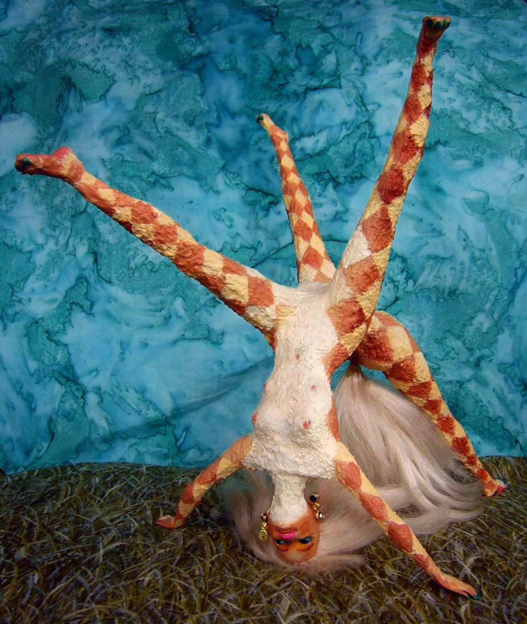
In Dyeing for Freedom, a shy girl paints on a bold harlequin pattern--curiously, the Kakalean meaning is quite like the Terran: a jester, trickster, troublemaker--and finds it such a license for outrageous behavior--the expression of her shadow self--that she just can't bear to wash it off! Not until she can own her talent for farce, promiscuity and rowdiness.She does, of course, in the end; Kakalean dramatic conflict is mostly emotional or sexual, and mostly comic, not violent or tragic as in so much Terran theatre. Maybe it's the result of evolving from herds of rather co-operative herbivores; or maybe it's an evolutionary legacy of Barbie.
HOMECOMING
A long day southeast to the Trislets, the lesser isles of this cluster. I didn't mean to imply there were only three islands total. The edge of a Rift is rarely so simple. The Trislets are a secondary chain to the east and south of the big three; from little Manhattans on up to four Oahus. You land only on the southernmost.
South a full day to little Eko... ironic name, given that culturally it is something of an echo, or at least a satellite, of the Trislands; the geometric fad has just begun here. A year behind. Audiences in the Trislands were large and of all ages; here, it's smaller and notably narrower, mostly the young who've adopted geometrics, or are considering it. They're enthusiastic but not big spenders, they haven't got disposable clan-credits to spend. You only play one night.
South for three full, dull days along a chain of islets, some uninhabited, some homesteaded, but with no ports to play in... until you reach the very last of the West Ibaris, F'zeh.
Small, low and rather arid for a western isle (we're nearing Iba again, and its presence upwind reduces rain), F'zeh still seems a giant after the last half-week. At least Eastport is a real town, where you can properly restock--and perform, to earn back what restocking cost. And after a final show (though only one, to a modest-sized audience, none of them geometric; your troupe skips Dyeing for Freedom and reverts to domestic sex-farce), your cat beats patiently back into the rather fickle winds for a long, long day...
Full circle! Or at least an L-shaped loop, some 9-10,000 km long, sailed in a couple of months. Not a bad theatre-season, by the crew's reckoning. And this is how thousands of ships like the Cheirin sail, shuttling mainland to isle, and isle to isle, weaving the slow Kakalean net.
LISTS AND LINKS: More worlds? Planetocopia! - dreams of other worlds - ecology - climate change - evolution - natural disasters - terraforming - sculptures and 3D art -
World Dream Bank homepage - Art gallery - New stuff - Introductory sampler, best dreams, best art - On dreamwork - Books
Indexes: Subject - Author - Date - Names - Places - Art media/styles
Titles: A - B - C - D - E - F - G - H - IJ - KL - M - NO - PQ - R - Sa-Sk - Sl-Sz - T - UV - WXYZ
Email: wdreamb@yahoo.com - Catalog of art, books, CDs - Behind the Curtain: FAQs, bio, site map - Kindred sites