
Kakalea:
PEM SISH ISLANDS
Outline only!
by Chris Wayan, 2015
Kakalea basics--map--geology--
creatures--
Building Kakalea
More worlds? Planetocopia!
Kakalea:
PEM SISH ISLANDS
Outline only!
by Chris Wayan, 2015
Kakalea basics--map--geology--
creatures--
Building Kakalea
More worlds? Planetocopia!
This page will eventually expand a good bit--the Pem Sish chain runs nearly 7000 km (over 4000 mi). But for now, this outline will have to do.
If you want a real sense of Kakalea's mid-ocean island chains like Pem Sish, for now your best bet is the Artaho Islands--at least that tour's written.
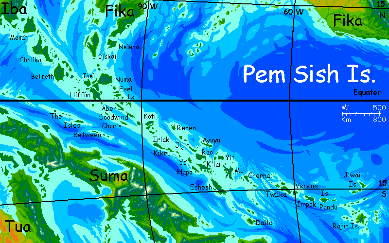
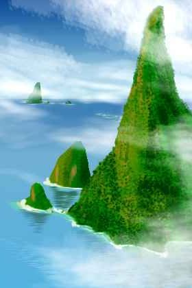
The lush Pem Sish Islands are rather like the islands off Southeast Asia. A sprawling, rugged tangle of reefs and islands--some volcanic and cloudcapped like Daito, Rao and Koti, some long lower ridges where it seems fracture zones have pushed or tilted fault blocks, like Eshesh, Irlak and K'lai.
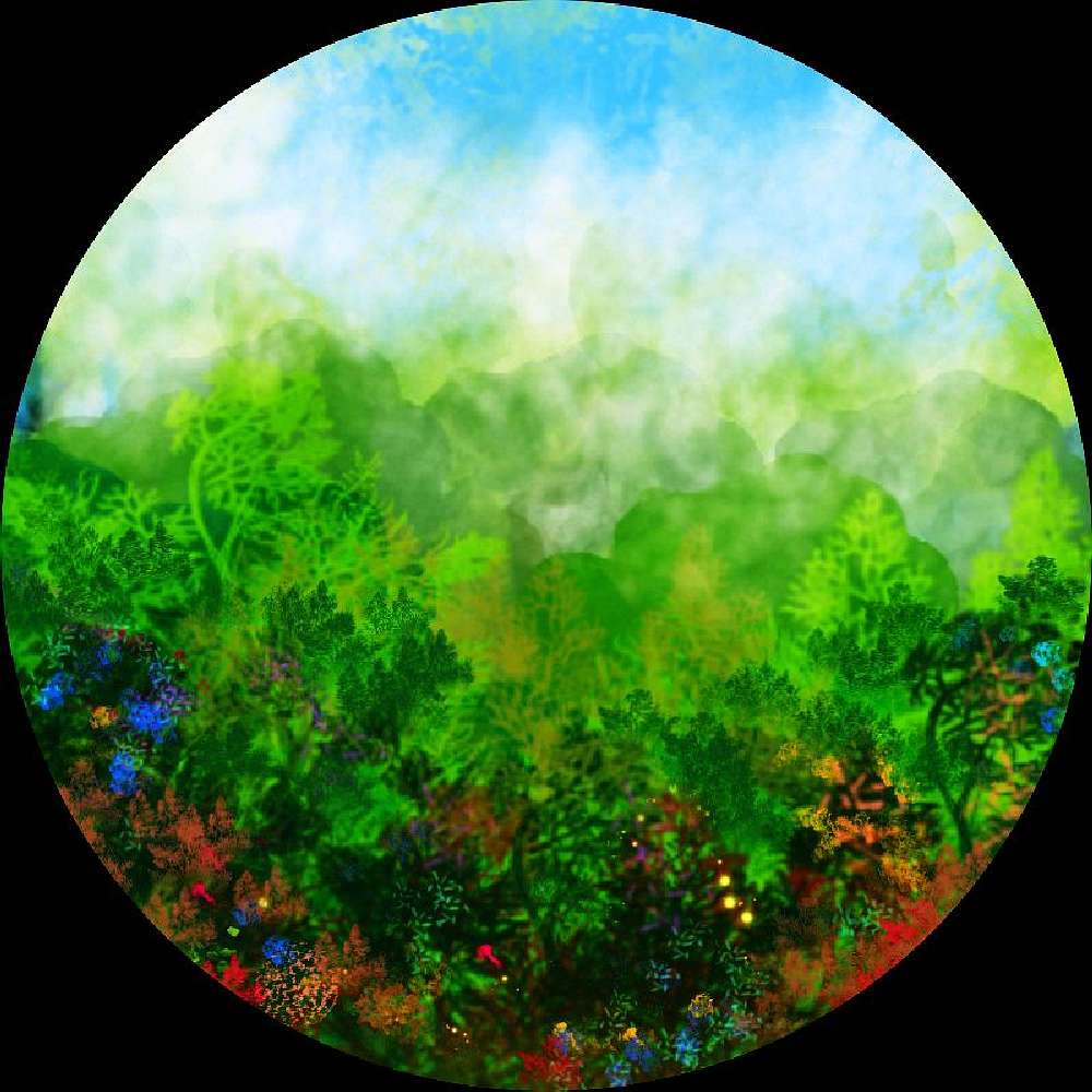
Nearly all the Pem Sish are rainforested--only the southernmost (least tropical) like Eshesh and Daito have "dry" sides, and they're not really dry--just open woods instead of jungle. No stretches of savanna or brush or pocket deserts here as in Hawai'i; these isles are lower and mostly more equatorial than our Hawai'ian chain, and both factors weaken rainshadows. Most places, it's wall-to-wall trees; any clearing means people are actively maintaining it.
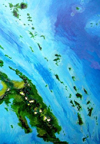
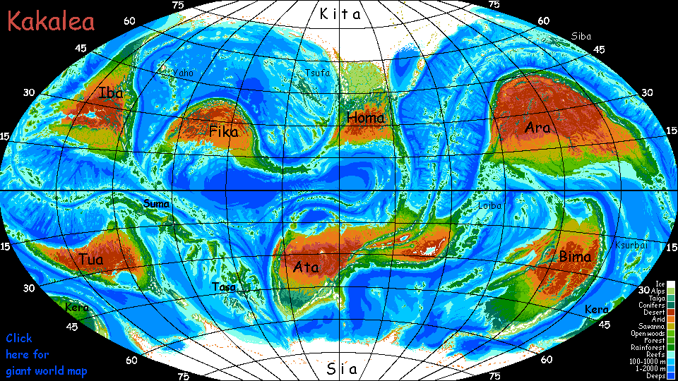
Here's the only cloudless orbital photo I've got; north is in the upper right. The big land mass is Suma, of course--a double-sized New Guinea. It too is the crest of the same mid-sea rift complex; but why the two rims are so far apart isn't clear. Is it forking as in the Red Sea, or running as parallel riftlets, as in parts of East Africa? Certainly such chains as The Isles Between are evidence of at least partial forking in the northwest, and the rift certainly splits in the far southeast.
Also unclear: why the Suma side rises so much higher--nearly continental next to the Pem Sish.
But in some ways, neither altitude nor land area are what matter to Kakaleans--linear miles of coastline are what matter. The interior's dense forest, often steep, mostly with streams too short and steep to be navigable. Ports, coastal plains and fishable reefs are what support a population. Even on Suma, most settlements are on or near the shore. And measured this way, the islands of the Pem Sish are respectable--nearly half the length of Suma's coast; with as much fertile shore as some continents.
The west is big--the biggest section of the Pem Sish chain. Forked, and both forks Indonesian in size.
Climate: warm and rainy, then hot and rainy, then rainy.
Did I mention rainy?
Because of those rains, most of the Pem Sish are smothered in jungle. Interiors are rugged too. Access is difficult. Most Pem Sishans live on shore and look to the sea. So the sheer size of the western islands does not mean more people live here; in fact the population center's well to the southeast, in central Pem Sish, where long narrow islands provide more coast per square kilometer.
I suspect for this tour you're going to be booking passage on a trader in art--taking the term art broadly. Small portable pretty things. Coral, for one. Pearls of course.
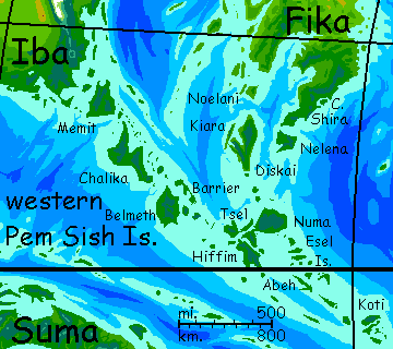
You start on mainland Fika, on the tip of the Shira Peninsula. Lush tropical forest.
Over the narrow strait to the isle of Nelena.
West to huge Diskai--up and around, down the west coast. This takes days--the lesser Isle of Kiara (still as big as Crete) shelters this shore, creating an inland sea full of coral bays. Rich trading here, and your crew can't be hurried.
From Diskai your cat heads west, round the southern tip of Kiara, and sails two days across the Rift--deep water--to equally huge Chalika.
Down the northeast shore, zigzagging between mainland Chalika and the hundreds of inhabited islets around it on this side. Like Diskai, a world of its own.
Southeast a few hours to Belmeth. More of the same--zigzags between the major ports of Barrier Island and Belmeth itself. But note that the population and prosperity are skin-deep. Villages form a simple ring round the coast. Inland Belmeth is steep, overgrown, wet, and nearly unsettled.
East a day or or two, stopping in the bays of northern Tsel, to equally huge Numa. Equally maritime Numa. No one lives inland. Kakaleans like it hot, but not this wet!
Three days through the Inland Passage winding between Numa, Tsel and Hiffim. A zigzag, more challenging than the seaward coasts, but twice as many villages and ports to trade in. First west, then south.
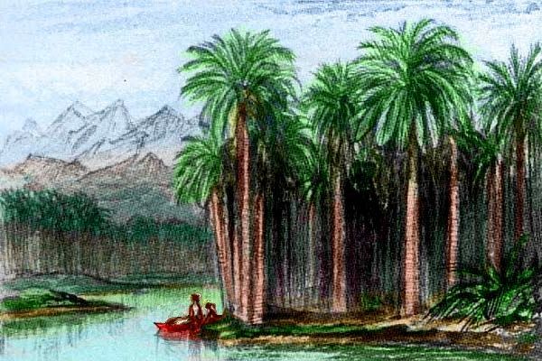
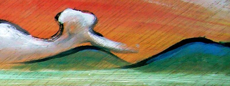
Here's a paint-sketch on some driftwood (all I had) of sunset in the Inland Passage on the second evening.
Days in this complex little group, only a fraction of the area of Diskai, Chalika, Belmeth or Numa, yet with nearly as much coastline, and sustaining nearly as large a population. Your cat zigzags south...
The last isle is different. Long, narrow, steep Abeh has impressive palisades and only tiny coves rather exposed to heavy surf, churning up the bottom. In places, the water's surf's a muddy green, not the crystalline water you've seen in the coral seas so far.
Abeh's actually more complex; it's a great V or Y shape where two such ridges meet at an acute angle; not so common. The bay inside the angle has sheltered water and most luxuriant reefs--and larger, more prosperous ports too.
But coming from the Esel group, the sheltered side of Abeh would require backtracking. It's a common problem here in the Pem Sish--a maritime version of the Salesmen's Problem. How to hit the best ports and minimize travel between? There's no easy answer and we'll inevitably miss a lot.
Southeast to Goodwind. This time your crew chooses the southwest shore, though there's little ecological difference: Goodwind is a simple, straight sliver, mountainous but with no dry side: storms blow lengthwise down the central ridge and both shores are equally emerald-green, with no towns (no large harbors, no navigable streams) but fishing villages every few miles.
On to the Koti Islands, portal to the Central Pem Sish. Your crew takes their time here, wandering its inland passages. Koti's a little world of its own, a cluster of volcanic islets nothing like the simple ridges of Abeh, Goodwind or Charis.
The central Pem Sish Islands are rather like the Lesser Sundas in Indonesia. No giants, but a steady sprawling tangle of reefs and islands. They're nearly all rainforested--only the southernmost like Eshesh and Daito have "dry" sides, and they're just open woods instead of jungle. No surprise: these central isles are lower and more equatorial than the Hawai'ian chain, both factors weakening rainshadows.
A third un-Hawai'ian trait: the scale. Kakalean seas are shallow, remember? Riffim and Eshesh are each over 400 km long (250 mi), and dozens of the Pem Sishes are larger than Hawai'is Big Island. More like our Caribbean, or an Indonesia with no giants, just endless county-sized islands...
These lands are close enough, and mountainous enough, so even primitive sailors could always see the next isle on the horizon. Trade was constant from the beginning. Still is. Socially, culturally and politically, Pem Sish is just as unified as any continent.
Your course runs from the Koti cluster due south a day or two to Irlak. Days down its long northeast coast.
Kikru and Little Kikru. Long steep ridges, all coast and no interior.
Due east a long day to Jijit. Down its southwest shore. Villages under cliffs. Small waterfalls. Like Kikru, a Jijit's an uplifted, tilted fault block paralleling the rift.
South an hour or two to big, volcanic Rao. You can't see the central peak: cloud-mantled as usual. Rao's north shore is a straight run, hills dropping into deep water; but the south is ragged, complex. Despite the navigational risks, your crew steers south. More villages, better trade around the sheltered inland sea between Rao and K'lai. Cross to the north shore of K'lai... east along it.
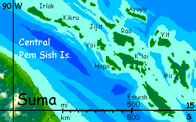
Up a flowering tree on Mu |
South down K'lai's more exposed west coast. At South Point, cross to long Hapo--one more ridge-isle. Up one long side, down the other, back to South Point...
Nearly a week wandering the peninsulas and bays of southern K'lai. Difficult navigation, but sheltered water, rich coral reefs, and prosperous villages.
South to Eshesh, largest of the group. Nearly a week here, too. While its shape is simple and its coast proportionally shorter than K'lai or Mu, sheer size counts for something. Down the west coast of Eshesh first. Hookport, in the southwest, sheltered by the only large cape on this shore, is the biggest city you've seen in the Pem Sish.
Back up the northeast coast of Eshesh. Small harbors, but nothing like Hookport.
East-northeast a full day to Mu. A wildly irregular cluster of ridges, Mu takes four days to explore even cursorily. North Cape, Southwest Cape, up the sluggish Nong to Lake Nimashi. Here it's not coral but hardwood carvers and herbalists your crew trades with. The rainforest is full of medicines and tonics valued all over Kakalea. It's just that getting up to the canopy where most of them grow is hard and hazardous. So much so that folks prefer fishing, hardly a safe occupation.
One result: Kakaleans never throw away unneeded medicine. You take it back to your herbalist who redistributes it. Way too costly to waste!
Down South Cape... Mu seems to last forever.
Notice that you could easily have designed a completely different route through the central Pem Sish that explored none of these coasts--hopping from Renen and the Colts to the north shore of Jijit, along the north shore of Rao, north to Ayuyu, south to Yit and through its Inland Sea, along the north shore of Mu, then the east, then south to the Daito Islands. Not a coast or port or person in common!
Yes, your experience would be similar--same ecology, topography, culture--but that's tourist thinking. Your crew are traders. Different boats each have favored routes with dealers, artists and suppliers they know and like. For them, the Pem Sish is a sequence of friendships not isles--each boat sails a different Pem Sish. The region's too complex a maze to have one optimal trade route. It's a judgment call, and dozens, perhaps hundreds of boats ply different, and not really rival, courses.
My point? Sometimes convolution and ambiguity aren't hindrances but elbow room. Just as a convoluted island supports more coral, a tangled archipelago supports a richer culture and economy. If the Pem Sish were a straight chain, a simple shipping lane, you'd see far fewer sails. Geographic complexity alone...
As the Pem Sish are the top of a mid-oceanic ridge, their waters are clean of continental silt and mud--the products of large rivers--so the high tropical sun penetrates deep. But the water's still fairly rich in nutrients forced up from the abyss, as deep currents strike the ridge. Nutrients plus sun equal coral! Some of the most luxuriant reefs in the world--and that's a high standard. Earth may be richer than Kakalea in most biomes, but NOT coral--these shallow seas and island chains are ideal for it.
But even for Kakalea, Pem Sish stands out. There's a large export trade in sustainably harvested corals--not for utility, but sheer beauty. Some end up as jewelry or semiprecious gems for inlay, but most is unaltered. Kakaleans like artifice and metaphor as much as the Japanese, but like them, they also prefer the casual asymmetry and innocence of natural forms. You'd think coral fishing would be a lot more reliable than fish fishing--they don't swim away, for one thing--but in fact the elusive quarry coral-fishers seek is not undersea but across it: the art-buying public. As fickle as any fish.
The result? Coral fishers have to be part farmers--tending their village's district, justifying each large cull to the village Coral Board--and part artists. Very patient artists! Corals can be not just chosen but shaped, slowly, carefully, as long-term as bonsai...
Plays like the classic I Dreamed I Sailed with Coral, in which the corals, wanting to become beautiful, give guidance to their sculptor through her dreams, are not really much of a poetic exaggeration.
The Wild East is different. Surreal. Dozens of volcanic plugs--the hard throats of old volcanoes--rise from the sea like fangs hundreds of meters tall. Since each is all that remains of an old cone kilometers high and wide, each crag is isolated; just a single tusk rising from an otherwise empty sea. At most, the next's a tooth on the horizon.
Earth has one such--Ball's Pyramid, between Australia and New Zealand. Truly a weird sight.
Lots of coral atolls are the eroded top of a volcano, and many do leave a crag or castle where the throat was; but it's usually modest in size. These aren't. 500-1000 meters tall, narrow, twisted, such crags look like old Roger Dean fantasy art. Nothing real.
Such monster sea-stacks are jaw-dropping, beautiful, but generally uninhabitable. Many can't even be landed on--sheer cliffs all round
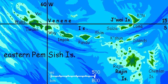
I'm exaggerating of course. The Venene Islands, the mid-eastern stretch of the Pem Sish, is much like the central cluster--the crest of the mid-oceanic ridge. Fijian islands, good-sized, mountainous. Some volcanic cones, but long ridges too. Coastal villages. And the northeastern J'Lai Archipelago is similar. Even the low K'shun Islands paralleling them aren't too different. Lonelier, as the ridge trails off and founders in the very middle of the ocean. But the K'shuns are just half-drowned versions of the central Pem Sish. It's really only the far southeast, the Rajin cluster, that turns strange and wild--spectacular and unpopulated.
Even some of the Rajin islets vary. Some have coral rings; as their central castles are better protected from surf, they often haven't eroded as starkly. Beaches, trees, non-verticality. But they are small, and populations are small. Not zero, but small.
The one great exception's in the heart of this cluster. Here on Rajin proper, a great central peak sends out long, branching, radial, fluted ridges, nappy green and waterfall-steep. The island's habitable land is thus sliced into wedge-valleys, each its own little world; much easier to float downriver, sail around the point, and back upriver than to climb those thousand-meter walls. Valleys vary from rainy (indeed, drenched) on the east and south sides, through savanna on the north and west, to near-desert in the northwest, in the lee of the central peak. Ecologically and culturally, it's many islands in one, much as the central Pem Sish was essentially one island in many.
The Chemlan Islands, east of Rajin, are odd, not fitting either pattern. It's a pattern of washboard ridges, most of them running roughly parallel with storm-tracks; so although the latitude's similar to Rajin, few islands have much of a dry side. Erosion has sculpted them into steep knifebacked walls not so different from Rajin's, but the origin's different--not volcanic but uplift.
Such ridge-fields are common near Terran rift zones; what's odd is how isolated this field is; in general the Pem Sish is roughly linear, with few isles too far off the ridgecrest; a pattern suggesting relatively fast spreading against low resistance. But such lonely ridge-patches occur even on smooth, fast-growing rifts, such as near our Pascua/Easter Island; if Earth's sea level dropped a mile or so, something quite like the Chemlan Isles would rise to the northwest. Why here? It's not chance. The rift forks in this area; from the Chemlans, a branch runs south all the way to the Antarctic. Seafloor is spreading in two directions at once, interfering with itself. Compression and corrugation result. It's like a choppy sea with waves reflected off a breakwater, at an angle--but this interference pattern is written in stone.
From the Chemlans you have several choices, though you may have a long wait if you don't stick with your current boat:
LISTS AND LINKS: More worlds? Planetocopia! - dreams of other worlds - ecology - climate change - evolution - natural disasters - terraforming - sculptures and 3D art -
World Dream Bank homepage - Art gallery - New stuff - Introductory sampler, best dreams, best art - On dreamwork - Books
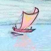
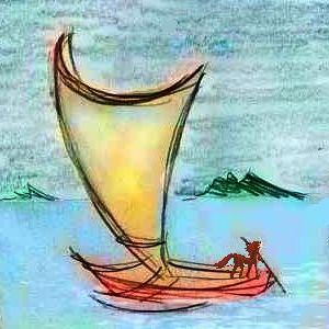
Ariel of K'lai dances I Dreamed I Sailed with Coral
Indexes: Subject - Author - Date - Names - Places - Art media/styles
Titles: A - B - C - D - E - F - G - H - IJ - KL - M - NO - PQ - R - Sa-Sk - Sl-Sz - T - UV - WXYZ
Email: wdreamb@yahoo.com - Catalog of art, books, CDs - Behind the Curtain: FAQs, bio, site map - Kindred sites