World Dream Bank
home -
add a dream -
newest -
art gallery -
sampler -
dreams by
title,
subject,
author,
date,
places,
names
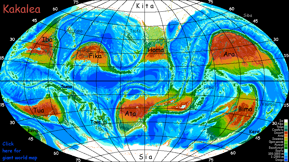
Kakalea:
SUMA
under construction! W end & SE (except Chark) just outlined
by Chris Wayan, 2012-2015
for the peoples of New Guinea and their thousand languages
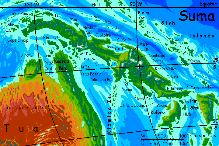
Kakalea basics--map--geology--
creatures--
Building Kakalea
More worlds? Planetocopia!
INTRODUCTION
Suma is a bit over half the size of Australia. Is it a huge island or a tiny continent? Geologically, Suma's not continental--just an Andean mountain range rising from a shallow sea, with wide alluvial fans and floodplains, but no real continental platform. Only Kakalea's shallow seas make it a continental contender. Such a chain rising from Earth's seabeds would be a mere island chain.
But ecologically, Suma's a shoo-in: it probably has more biomass than its continental neighbors Tua or Fika. No mystery why! Suma is equatorial, and most of it is dense rainforest, the largest on Kakalea; even its driest patches are grove-and-meadow patchworks or tree-dotted savanna in a land where (miraculous on Kakalea!) the rains never fail. No desert at all.

Well, except high up. Although Kakalean life evolved to cope with thin air, life still thins out sooner than on Earth; it gets sparse above 3 km (10,000') even at the equator. At that height, oxygen levels are like Earth's at 7600 m (25,000'). It's dry up there, too: above most clouds. The snow's mostly from thunderheads mounting almost into the stratosphere. Suma's spine, especially in the southeast, is so high that the snowpacks accumulate into small glaciers--more extensive than New Guinea's as the peaks are higher and the air thinner.
Such comparisons are obvious--Suma, especially its northwestern, equatorial half, is much like an overgrown New Guinea applying for continental membership. The main difference? More diverse climate. Suma's southeast runs much further from the equator and is drier and more open. But overall, color it green.
Further, Suma's rainforests (like all on Kakalea) have a resilience Earth's rainforests don't. Heavy rains leach soils; our rainforests are nutrient-starved, by savanna or temperate standards. The rain creating all that luxuriance also limits it! In a jungle, life feeds on life; the soil is a mere matrix with little left to contribute. What sustains our rainforests is a second, subtler rain: of fine wind-blown dust from our deserts, injecting minerals into the system, replacing the nutrients lost in the megatons of mud slipping down those swollen rivers.
You can see where this is going! On Kakalea, cursed with huge deserts, the skies are sometimes tinged pink with dust. Here, rainforest soils are steadily replenished, at a rate perhaps twenty times that of Earth's; cut or burn these woods, and the soil won't crust into barrens needing generations to heal; regrowth is swift. Indeed these tropical forests are just as resilient as Earth's temperate woods.
That said, this rich and highly productive land may be a cultural backwater. Kakaleans are more likely to evolve from savanna and be comfortable in it. Why? Simply that there's so damn much of it. I don't think there's anything magical about savanna just because intelligence arose there on Earth. Too many other environments, from reefs to forests and subpolar to equatorial, have evolved brainy creatures; I suspect it's largely chance that a savanna ape happened to start our local tool-use singularity! But on Kakalea, the overwhelming majority of large land animals live on savanna; forests (tropical, temperate or subpolar) are scattered and small. So Kakaleans may simply be maladapted for rainforest and not settle here--except for the savannas around Thenga Bay and Sasa Plain, they may find it unbearably humid and closed-in. Who knows?
Suma has a temperate twin on the far side of Tua: Kera. It too is densely forested, with a biomass bigger than many full-sized Kakalean continents. Including these two, um, lands, Kakalea has nine large land habitats, seven of them dry. No jokes about Seven of Nine, please! Besides, it should be Six of Nine: Bima, though it looks Australian enough with its huge central desert, is still more than half nondesert.
My point? Suma's not unique. Nothing but their chance locations and orientations keep the dry continents barren. And as they drift, they'll green!
TOURING
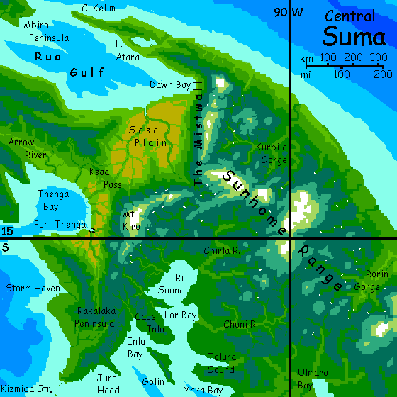
The winds off Suma favor a counterclockwise voyage: we'll start at Cape Fash, Suma's eastern tip, run west along the northern shore to Cape Irikip, then slowly southeast (against the wind, much of the time, but it's unavoidable one way or the other), past the tip of the Australian-like continent of Tua, back along the southern coast to Cape Fash; then we'll circle the big satellite islands of Koloro and Hin Shoi. From here, travelers can take ship deeper into the Tasa Archipelago, smaller than Suma, but just as fertile.
Or you can run with the wind down the Pem Sish Islands, the big tropical chain north of Suma. We'll end where the chain forks, one branch leading to the continent of Iba, one to Fika.
You can venture inland to see the sights, but not far; you simply can't climb far into the mountains, let alone cross them. Only Ksaa Pass at Suma's narrow waist is low enough to be safe for Terrans. The danger's not snow (though a few of these equatorial mountains are high enough) but oxygen shortage. Since sea-level air is already thinner than Earth's and drops off faster with altitude in Kakalea's higher gravity, passes even 2 km high (6600') are quite dangerous for Terrans, and 3 km (under 10,000') are slow death.
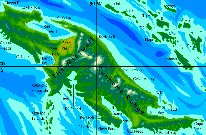
NORTH SHORE
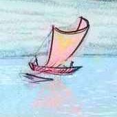
You start in Cape Fash, bartering for a deck-pad aboard a midsize catamaran, the Lorim, circling Suma. We sail west along a lee shore at what seems a fierce pace, 12 knots (20-25 kph). But this is slow by Kakalean standards--these are shipbuilders on a par with the Polynesians. Their cats, running with the wind, routinely cruise at 15 knots and can easily sail many hundreds of km a day. Your ship is a slow tub because it serves a double purpose: it's a floating theater. Usually, props and sets are unloaded and set up in the local music-inn or the town plaza, but if needed the Lorim can stage stripped-down shows on deck.
My sketch isn't terribly accurate--she's too stubby, with heavy masts and too-small sail. I omitted some ropes I didn't understand, and a removable shelter on the deck because it hid too much else. But the basics are right. Asymmetrical hulls, one big one small; lateen sail, wishbone boom, less rigging than on a European oceanic vessel from the Age of Sail.
This troupe stages original plays and dance performances up and down the Suman coast, with a secondary line in books and pamphlets (printing is costly, though, so the market's limited; few individuals own books. Most villages share a lending library, and the fines for loss or damage are serious. So the crew expects to sell just one copy per town; but at Kakalean book-prices, that's enough.)
Such theater-boats aren't rare; they act as news disseminators and mail service all over Kakalea.
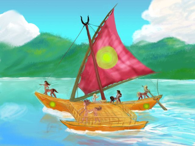
Anyway, this is a clan of chatty, informative, sophisticated artists. You're not sailing with Ahab's scary crew, nor with Captain Bligh; more like sailing with Shakespeare and his players. Except of course they're centaurs. Small centaurs, but they do take up space...
On the other hand, women aren't forbidden as they were on Shakespeare's stage. Girls roam as free as boys, and occupations aren't strongly gendered--women are lumberjacks, astronomers, shipbuilders... and traveling actors. The crew includes males, females, young, old...
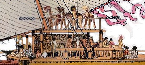
The Kisharo, a floating theater, after an on-deck show; crowd lingers, discussing play
Just a couple of days, and we enter Rilin Bay. At noon on the third day, we dock in Port Rilin. Which I'll eventually have something so say about. At the moment I can't even visualize the town--too hidden under lush trees and vines.
The next day, reaching east then north round Ril Head, we skirt rugged, cloud-topped Cape Kep. Along the north coast...
Orlei Valley, and a couple of days further up the coast, Rorin Gorge, along the steep northeast face of the Sunhome Range: lush green, like the wet side of Hawaii. Crags and waterfalls, a few rivaling Angel Fall. On the next map I've marked known falls over 50 m in white. A hundred or more!
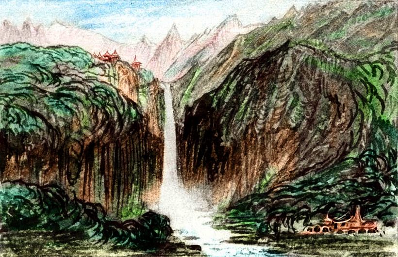
Given how rainy the mountains seem, why are they called the Sunhomes? They rise as high as 5 km (16,500') along the divide--well above the cloud cover. Their icy peaks are in near-perpetual sun. In Kakalea's thin air and stronger gravity, tropical clouds thin out only waist-high on these giants. Rainforested feet, dripping foggy cloudforest on their knees, pleasant springlike country on their flanks (tea, anyone?)... but their shoulders are dry alpine meadows thinning into barrens, then snow.
Round Cape Kelim, into Rua Gulf to the Mistwall; hanging canyons and crags reminiscent of Machu Picchu. I haven't bothered marking falls along the Mistwall; basically every creek is a cascade. This great scarp averages 45-60° slopes.
The Mistwall (and the Kiro Mts further southwest) are a fracture zone where the great rift/ridge complex creating Suma apparently kinks. The two segments, as they spread, collide at an angle--and one's ridden up above the other.
We're used to thinking of high mountains as rising only where plates hit head-on, as with the Andes or Himalayas. But a rift and its fracture zones can create big, rugged ranges and huge volcanoes--the mountains of East Africa are a good example.
All of Suma's basically one raised lip of a midsea rift (the Pem Sish Islands are the other), much like the rift creating our Red Sea. These Suman waterfalls and rugged mountains aren't just scenic decoration I added arbitrarily. This is young crust under multiple pressures--and responding vigorously.
You'll notice I've highlighted Suman scenery more than architecture, and what you've seen looks like basketry. It is. Sumans build light, small and in organic shapes that can sway with the wind--or earthquakes. Sumans are sophisticated culturally, but they've learned the hard way not to build large monuments in stone, or halls with heavy roof-beams. Fortunately the climate's so warm that mere thatch is quite adequate for a roof.
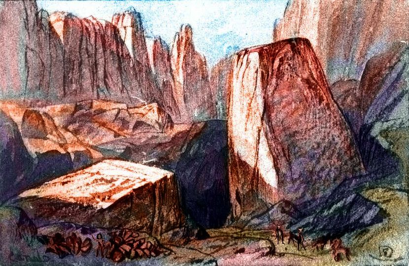
Below is a sketch (based on one by Edward Lear the nonsense-poet--he was a gifted landscapist and I've based many of these scenic sketches on his compositions) of the Mistwall from Dawn Bay.
The Sasa Plains at the Mistwall's foot: the nearest thing to an Outback on Suma. Desert it's not! But this tree-dotted golden savanna a few hundred km wide is as dry as it gets anywhere on Suma--unless you're atop the Mistwall or Sunhomes. And if you're human and you're fool enough to try climbing up there, you're dead.
Out of Rua Gulf, west along Cape Mbiro. Green, green. Not quite as misty and lush, nor quite as rugged as the Sunhomes.
Nesha Bay: the coastal plains here are opener again, almost Mediterranean. The mountains cupping the bay cast a strictly local rainshadow. The winds our ship is riding, port to port, blow consistently northwest.
Cape Zam, Zim Island: green. But Zum Bay (yes, Zim, Zam, Zum--you can't accuse the locals of fickleness--once they find consonants they like, they stick with 'em. Though they do pronounce it Zoom, if that's a consolation)... Zum Bay, like Nesha Bay, has Mediterranean groves and meadows. Local rainshadow again.
The long green coast leading to the Chorto Islands and wide Chorten Bay. All emerald, all lush. We're so close to the equator now that there is no dry side. Or dry season, really. Rain, sun, rain, sun. You get used to it. You notice a rattan chart pegged up for the steerswoman to consult instantly, and the lookout hoots frequent warnings down. Chorten Bay's full of coral reefs. But then much of the north is. Anywhere shallow enough...
The maze of islets and sounds of the Lelek Peninsula. Like coastal Vietnam? Limestone crags mushrooming with greenery in the regular rains. Again, spectacular reefs.
Through Shr Strait on Cape Irikip. Muggy and green.
IBAT OR NOT?
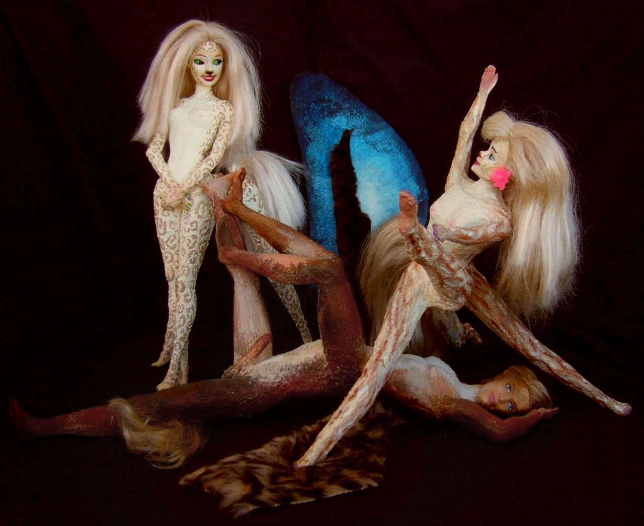
Here at the western tip of Suma, a choice. You could continue running swiftly with the winds westward, along the Ibat and Twibba Islands--twin chains of volcanic and fault-block islands flanking the mid-sea rift (spreading zone) that created Suma. At least you could if I'd written that (de)tour yet. So far, all you'll get is a map, an orbital photo, and an outline... wait, now there are some portraits of the strange form intelligent life has taken in these lonely islands: reefmaids.
 Rainforested, these small chips off the Suma block wind for at least 8000 km (5000 mi!) until the rift veers north into a dry zone. Not that the islands stop rising after that bend--the sea's too shallow for that!--but ecologically and culturally the Ibara Islands are quite different. North of them, the same rift/ridge creates the Nordic isle of Siba, different yet; then a long, temperate, twin chain, the Artaho Islands East Ata, on the far side of the world--directly antipodal to the eastern Ibats and Twibbas.
No surprise there! Earth's rift zones are all connected too; our high seas just hide the links between the few islands that break the surface. Iceland and Easter Island aren't obvious partners, but they really are bumps on the back of the same sea serpent. On Kakalea, the connections are easier to trace, that's all. Not just the Midgard Serpent but the Worm Ouroboros, biting its own tail...
SOUTH SHORE
From Shr Strait, we reach south round Cape Irikip then east along the Cloudy Bight. Green, green. A slow journey; the winds are slack and we're tacking into them.
At last Ot rises offshore, an emerald seen through mist. Through Ot Strait and into Lirip Bay to Port Ill, which, to your surprise, is quite sunny--a local gap in the clouds. The plains upriver are open forest--the first natural meadows and glades you've seen in weeks. Though the trip southeast has been slow, we have been creeping away from the equator; we're far enough away now that rainshadows are possible again--given high enough mountains upwind. The Ka Range qualifies--as high as the Sunhomes, though less extensive--the climactic range above the clouds is a tangled knot just a couple of hundred km wide.
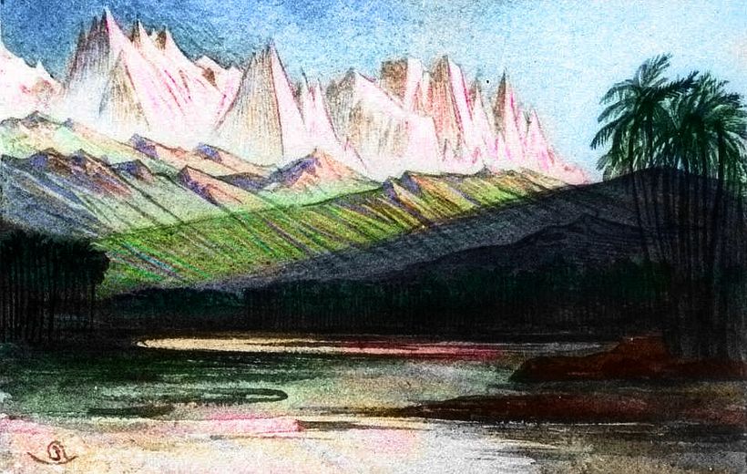
Threading the Chish Islands... On the mainland, we pass Mt Ka itself, getting a rare glimpse through the Amazonian cloudlayer, 5500 m above us (over 18,000'). Tropical ice! A little more common on Kakalea than Earth, since peaks don't have to reach quite as high, but still... Head to toe, Ka is as tall as Denali, taller than Kilimanjaro. And some of its flanking peaks rise right straight from the water. Little fishing ports; the coast road here is poor and washes out many winters.
Reaching into the Ka Bight. Ka Town has an unusual character; you recognize some North Coast items and accents. Nesha Bay is just north of us, over a 2500-meter pass, the lowest in northern Suma. Though you can't safely climb it (oxygen levels like at 6800m/22,400' on Earth), the locals can--with difficulty. And profit. Because of the difficulty.
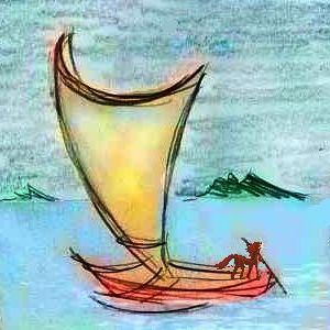
Kanesh Pass, western Suma. For scale, note caravan guide in lower left.
What's that bumper sticker? "Convenience breeds apathy"? In Kanesh Pass, a skewed reverse is proven true: inconvenience breeds prosperity.
Out of Ka Bight, south. The Chuun Heads--four small capes like fingers of a hand. Rugged little fjords between, each with a small port at the head. Sunny, sheltered--the heads lie across the prevailing windes. Lovely, snug, feeling small-scale after the Andean scenery of the last week.
The long straight shore of Cape Dzura. Green, monotonous... and distant. Days of tacking, well out to sea. Our ship, like most Kakalean vessels, is a rather Polynesian catamaran; it sails faster and closer to the wind than a European vessel, but coming about is slower and more complicated--basically, the ship reverses course, the stern becoming the bow. The ship's asymmetrical side to side, not fore and aft! The (permanently) windward side has a smaller hull meant to lift partly from the water in high winds--its weight makes it impossible to capsize. The large leeward hull carries most of the supplies. What this all means is, to tack we must reverse course and restep a sort of boom-mast; slower and more work than letting a boom swing overhead. So our zigzag course east is, um, coarse: fewer and larger tacks, reaching miles out to sea. And we avoid tacking too close to shore.
Not that it's deadly; small rocky heads, but mostly it's sandy beaches. But mud bars lurk near-shore, and no greater humiliation exists for a Kakalean crew than to run aground from a laggard reversal. The locals aren't pirates or wreckers--they'll tow you off the bar, all right. But they tow and tell! In two months, every sailor in every inn from here to Tua will be snickering.
THENGA
So at first you miss the mouth of Thenga Bay--we're so far out you don't even know we're in it till we head due east, not a tack but a steady reach across the wind into the passage, 100 km wide. Just dim humps and attendant clouds northwest and southeast. And ahead, just deep water where Suma should be! Though you know it's not open sea; sheltered, with low swells. Still, it smells like sea and looks like sea: this oval bay is 3-400 km across. The ship nears the southern coast and runs east a full day, to sunny Port Thenga.
Why sunny? Port Thenga usually is. It's built in another local rainshadow. Here a narrow savanna meets the sea at the foot of Mt Kiro, a cloud-skirted white-headed monster over 5200 m high (17,200'), rising straight from the coastal plain. A wall of such giants marches north and a bit east toward Ksaa Pass. If this huge transverse scarp right across Suma looks familiar, it is: this is the south end of the Mistwall, looming above Sasa Plain and Rua Gulf.
Ksaa Pass, a few days' trek northeast, is a mere wrinkle below the Mistwall--just 1500 m high (5000'). It's the easiest pass across Suma's spine for the locals, and the only one human tourists can use at all.
I did not say "safely"; the oxygen equivalent on Earth would be 5900 m or 19,400' up, worse than the summit of Kilimanjaro.
THE LENS
We reach back out of Thenga Bay and turn almost due south. Gentle winds along a lee coast that zigzags for days. We sail closer to shore here as we needn't tack between most of these harbors; generally south not east. We're creeping out onto the Rakalaka Peninsula, Suma's largest deviation from its generally straight slash along the rift zone to the northeast.
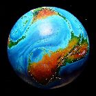
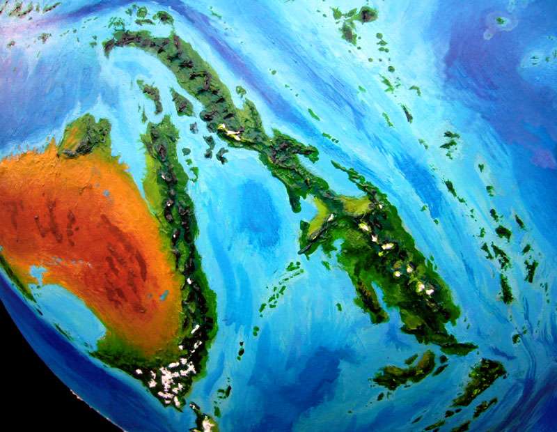
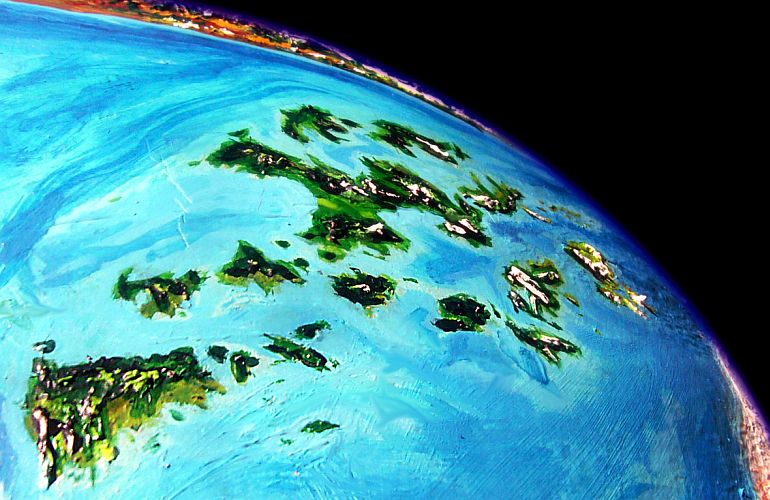
A few days later we reach Kizmida Strait at Rakalaka's tip. Unimpressive from sea level--just a few guano-stained islets hint at the Kizmida Islands to the south. Yet this chain includes islands hundreds of km long and runs some 2000 km, cutting across three climate zones--tropic, subtropic, temperate. Volcanic, with wet and dry sides like the Hawaiian Islands... except that many are active, not just the one presently above a hot spot as in Hawai'i. The Kizmidas may be, instead, a fracture zone whose slippage is so active it's becoming a plate boundary. The vigor's undeniable: after the Kizmidas come the huge Isle of Koren, and equally large (if less fertile) Orath Peninsula, on the antarctic continent of Sia. The southern Orath Mountains are buried under Sia's ice mantle, and the Kakaleans haven't traced them very far--they're generally not polar explorers. But this high-orbital shot from over the south pole hints that the range crosses the continent to re-merge with Suma's riftzone south of the Tasa Archipelago (top center).
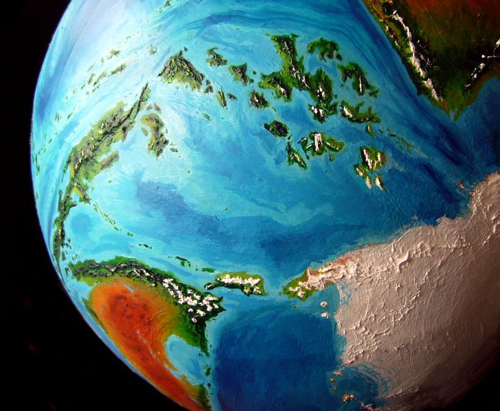
This great lens-shape (left-to-right in center) suggests Suma and Tasa ride atop their own tectonic plate, reminiscent of our leaf-shaped Philippine Plate, though larger.
Sorry. That God complex again. We're just on a boat in the tropics looking at a few sea-stacks. Don't mean a thing.
To a tourist's eye!
RI SOUND
Ri Sound is a large, complex region, densely populated, very green. Many side valleys run deep into the Mistwall and Sunhome Ranges. Visiting these ports will take a couple of weeks. This outline will expand a lot...
Juro Head, Port Juro
Inlu Bay
The lee side of Golin. The windward side resembles our Big Sur--steep grassy hills and cliffs plummet into the sea. Scenic, but not one decent harbor.
Port Lor.
Ri Sound proper. Clockwise round the bay, just to be unnatural. Port Ri itself, in West Inlet. Port Kiro. Port Chirla, the largest and wealthiest. Some would say snobbiest too.
Back out the east shore of Lor Bay. The Choni Valley Cooperative.
Tolura Sound. Traders generally skip this narrow bay but as your vessel is a floating theater, there's money to be made and free meals to be gained in neglected ports. The only critter to rival naked apes in their neophilia (no, not necrophilia. You want another planet) and capacity for boredom is the Kakalean centaur.
Yaka Bay... and it's back to open water!
A long stretch where we'r'e forced to tack well offshore of the Plesh Peninsula. Overall, a dull week.
CHARK
Near the southeasternmost tip of Plesh Peninsula, to avoid the hullripping rocks off the Hook, we tack so far out that the Isle of Chark swims into view. A long rocky spine with scrawny gardens and orchards between stark ribs. Fishing hamlets. Wind. Most theater-boats don't stop here--"Like a Charkan" is the Suman idiom for "rustic".
But on impulse, the crew votes to dock at Great Chark (so-called. A small town. But the town!) and try a gamble of sorts. The few troupes that visit play broad comedies or sad sea-tales of lovers lost. Playing down to their audience--as perceived.
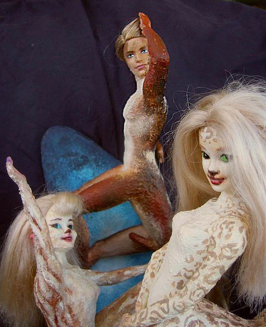
Bergia, Kentaur and Shya in The Triangle
|
But your troupe tries an experiment: a substantial romance whose conflict is ethical (is Bibari honest with her two lovers? Do they mind sharing?) and the action emotional not physical--though no Kakalean theater has anything like Shakespearean swordplay. But then Shakespeare wasn't allowed erotic dances, either.
Oh, well.
Pub-lanterns stay lit deep into the night, as the Charkans argue over rootbeer (alcoholic, made from roots; I can't help how it translates).
Curiously, they don't split along gender lines (and you just know they would in an insular human community); on Chark, the faultline is sociability--the extraverts feel whatever works, works, while introverts argue there are hidden costs to Bibari and her mates because they overlook each others' unacknowledged feelings--a possessive passion in Rusu the nut-farmer, a taste for freedom and romance in Bibari the singer, a maternal colt-hunger in Dzoa the goldsmith...
An analogy could be made with the unacknowledged (until now, but just confirmed) Charkan hunger for intellectual substance in its theatre. Rustic, yes; but serious.
Absent, of course, is a position you'd hear in a human bar: "Triangles always blow up". Kakaleans are sexually more promiscuous than humans (centauroid pregnancy and birth aren't as onerous or hazardous; also, Kakaleans may eat fish today, but they evolved as nomadic herbivores, and aren't too territorial; jealousy about one's genetic investment is less urgent if food's not the worst bottleneck and playmates for one's colts are advantageous; and sex bonds the band). Couples are most common but trios and quartets are not rare. More help raising colts!
So even back-of-beyond Charkans don't question the number of spouses--just how each of them sees the marriage. Sorry, didn't I mention it's a marriage? Right, that's illegal most places on Earth.
Oh, well. But not about Kakalea this time, for once. Poor old Earth. Buried in jealous gods like most of Kakalea is in sand...
By the way--these Charkans look quite scruffy and piratical. It's all those eye patches and hooks. Who have these folks been fighting, you ask?
Just the sea. No matter what planet you're on, sailors get lopped. Beams swing, ropes tangle, bones snap...
Oh, well.
But their misfortunes make for a startling scene. Pirate centaurs, unselfconsciously arguing over your spiritual responsibility to voice your dreams to your husband and wife.

Shya, Kentaur and Bergia in The Triangle
ULMARA AND THE WIND
Next morning it's a steady (if hung-over) reach across the wind due east, toward the mouth of Ulmara Sound. A huge, productive region--Suma's biggest single farmable lowland. This will be a side trip of a week at least. Only two days to reach Port Ulmara--running with the wind--but to leave again means sailing right into the wind up the long narrow sound. Dozens of hundred-km tacks.
As a result, though Port Ulmara serves one of the most prosperous regions on all Kakalea, culturally it lags behind more easily accessible ports. Chicago, not New York. And always a bit sensitive about it. Can whole cities have an inferiority complex?
The long fast reach, with no tacking, along Suma's southeast coast to Cape Fash again. A windward coast, so the crew will be watching the weather closely; in storms this shore can be dangerous. Luckily there's an excellent harbor halfway, Gullet Sound, between two long heads--still a bit exposed windward, but far safer in a blow than the long straight coast to the west.
OUTLIERS
KOLORO
From Gullet I think we'll take a side trip south, round the great Isle of Koloro, nearly as big as Madagascar, and ecologically a bit similar--narrow wet east, drier west.
We reach along Koloro's sheltered northwest shore. Open savanna. Almost African. So unlike most of Suma!
That's Orem off the starboard bow--what's serving for a bow at the moment, at least. Through the Straits of Orem.
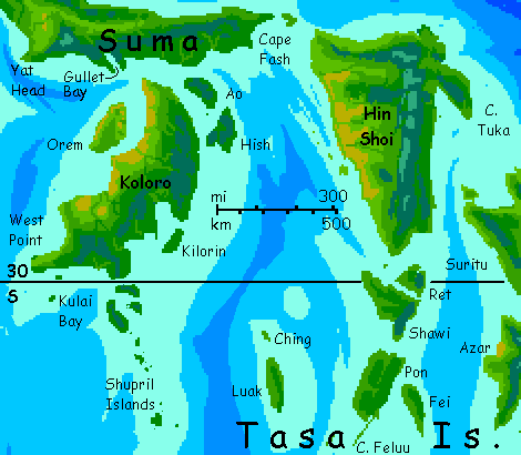
Tacking up through the sea stacks and islets around West Point, across Kulai Bay to Cape Shup (rhymes with soup) and its attendant Shupril Islands.
The windward capes and (luckily) island-sheltered bays of southern Koloro. Green rising to cloudy mountains--this is the wet side. Rainbows.
A fast run north, either along the coast or out to Ao and Hish offshore. Either way, we'll end up off Cape Fash where we began--unless of course you came here from one the neighboring continents or archipelagos, in which case you may have missed the sail up the north coast we started with! Hypertexts and webmazes by nature can't tell linear stories; what I'm writing (slowly; sorry!) are cycles, following Kakalean shipping routes. On Earth, only Australia could be circled this way, at least pre-Canal. But on a world whose lands are scattered, with living coasts and dead hearts, Kakalean ships ply the coasts, riding wind and current round.
And "Who am I to blow against the wind?"
HIN SHOI
From here we can sail down the west coast of Hin Shoi, an island even larger than Koloro, but similar: a sunny, open (but not desert) west, a mountainous spine, a cloudy, drenched south and east.
Three days later, at the southern tip of Hin Shoi, we face a choice. Hin Shoi's arguably not an outlier of Suma but the first of the Tasa Islands, a huge temperate archipelago. All of Tasa's fertile--hard to have an inland desert without an inland! It's perhaps more suited to farming Kakalean style than Suma's rainforest; in any case Tasa's biomass and population are basically continent-sized, like Suma's.
Anyway, a day's sail further south or east gets us indisputably onto another tour entirely.
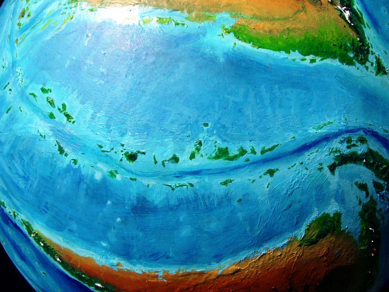
Below: Hin Shoi, foreground; Great Tasa, center; West Ata, horizon; icy Sia, right.
PEM SISH ISLANDS
The alternative to Tasa is a quick run up the east coast of Hin Shoi and back into the tropics along the lush Pem Sish Islands--rather like the Lesser Sundas in Indonesia, but the chain runs nearly 7000 km (over 4000 mi). Remember, it doesn't take much in these shallow seas to create a large island, and Pen Sish is the opposite, slighly lower rim of the same rift creating Suma--much like our Red Sea, with the highlands of Yemen and Eritrea a few hundred miles apart. Pem Sish is a sprawling, rugged tangle of reefs and islands--some volcanic and cloudcapped like Daito, Rao and Koti, some long lower ridges where it seems fracture zones have pushed or tilted fault blocks, like Eshesh, Irlak and K'lai. They're all rainforested--only the southernmost like Daito have "dry" sides, and they're not dry--just open woods instead of jungle. No savanna or desert here; these isles are lower and mostly more equatorial than the Hawai'ian chain, both factors weakening rainshadows.
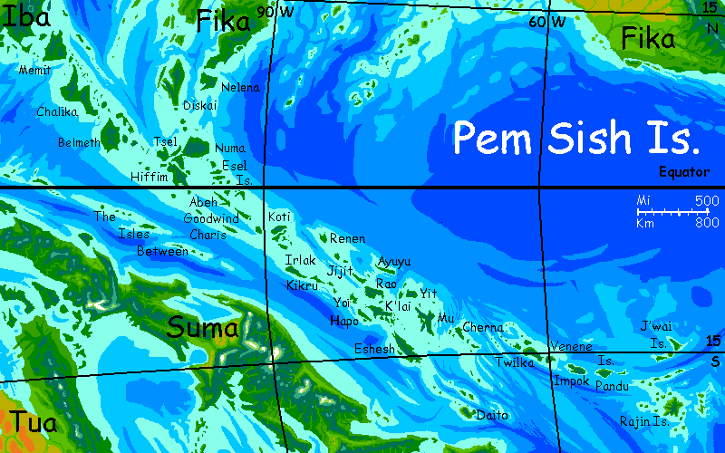 A third un-Hawai'ian trait: the scale. Kakalean seas are shallow, remember? Riffim and Eshesh are each over 400 km long (250 mi), and dozens of the Pem Sishes are larger than Hawai'is Big Island. More like our eastern Indonesia--no giants, just Timors and Sumbas... on to infinity. But that's another tour...
 Kakalea basics--map--geology--
creatures--
Building Kakalea
Kakalea basics--map--geology--
creatures--
Building Kakalea
LISTS AND LINKS: More worlds? Planetocopia! - dreams of other worlds - ecology - climate change - evolution - natural disasters - terraforming - sculptures and 3D art -
World Dream Bank homepage - Art gallery - New stuff - Introductory sampler, best dreams, best art - On dreamwork - Books
Indexes: Subject - Author - Date - Names - Places - Art media/styles
Titles: A - B - C - D - E - F - G - H - IJ - KL - M - NO - PQ - R - Sa-Sk - Sl-Sz - T - UV - WXYZ
Email: wdreamb@yahoo.com - Catalog of art, books, CDs - Behind the Curtain: FAQs, bio, site map - Kindred sites