
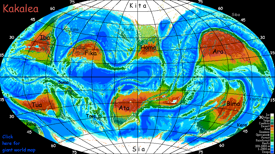
Kakalea:
TUA
by Chris Wayan, 2012-2015
for the Aborigines
Kakalea basics--map--geology--
creatures--
Building Kakalea
More worlds? Planetocopia!
Kakalea:
TUA
by Chris Wayan, 2012-2015
for the Aborigines
Kakalea basics--map--geology--
creatures--
Building Kakalea
More worlds? Planetocopia!
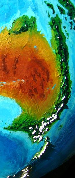
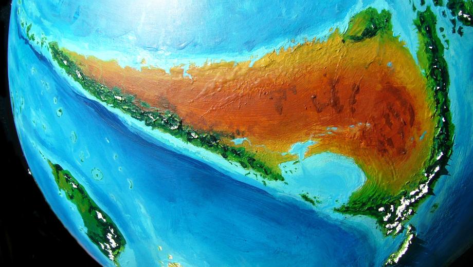
Tua is a small southern continent, only 16 million square kilometers (about 6.5M sq mi)--just smaller than South America. But that's the wrong continent to compare it to. Aussies will recognize it instantly.
Tua started this whole planet. I was staring at a thrift-store Earth globe, feeling bothered by Australia's red eye glaring out from all that blue. Water, water everywhere, but none of it getting inland!
So I got out my paints and started laying on ochre and iron oxide, enlarging Australia, and then building another Oz in the same latitude. And another. And another. The shapes varied, but they were always rainshadowed and dry-hearted.
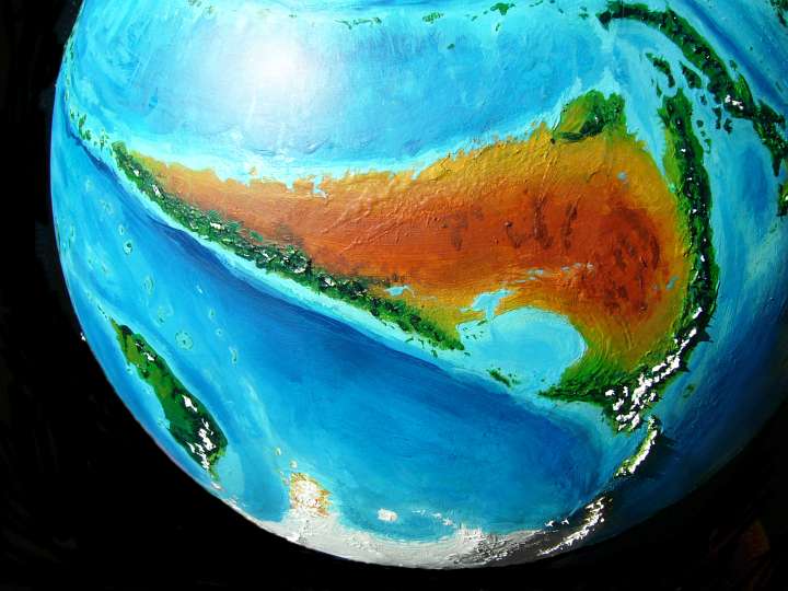
I didn't disguise Australia much. On Tua:
But despite all these cosmetic changes Tua's still basically Australia with a Groucho Marx mask on. Well, and a large erection.
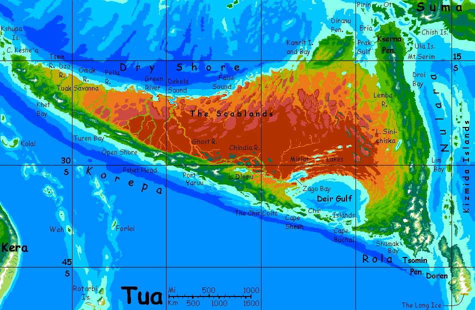
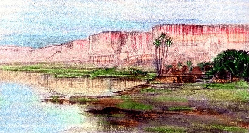
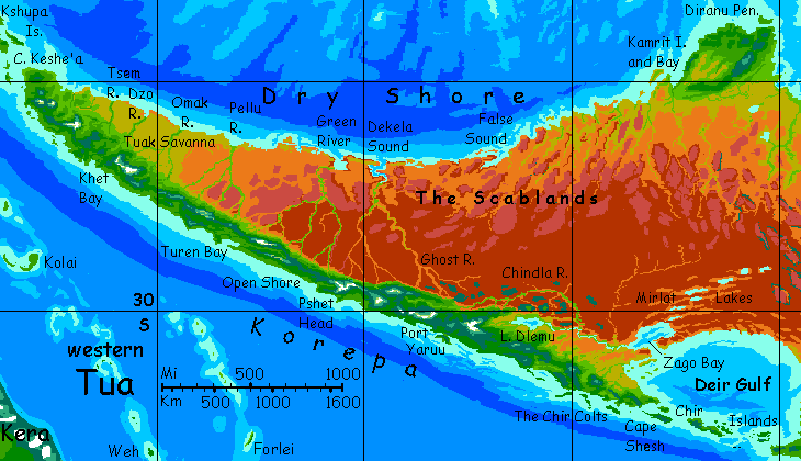
We'll start our tour round the (relatively) fertile Tuan coasts on the Kserna Peninsula in the tropical north. We set out from the port of Kserna Head, on the strait between Kserna and the Isle of Pirin, and sail east round Ot Point, then south.
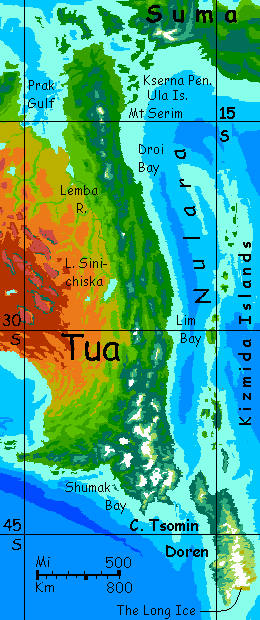
For a couple of days we thread out way cautiously between the rugged mainland shore and the Ula Islands. Between green and green. Well, reef and reef, really; we skirt the land warily. This turquoise sea is shallow and coral-crusted.
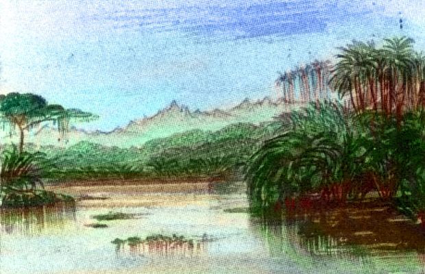
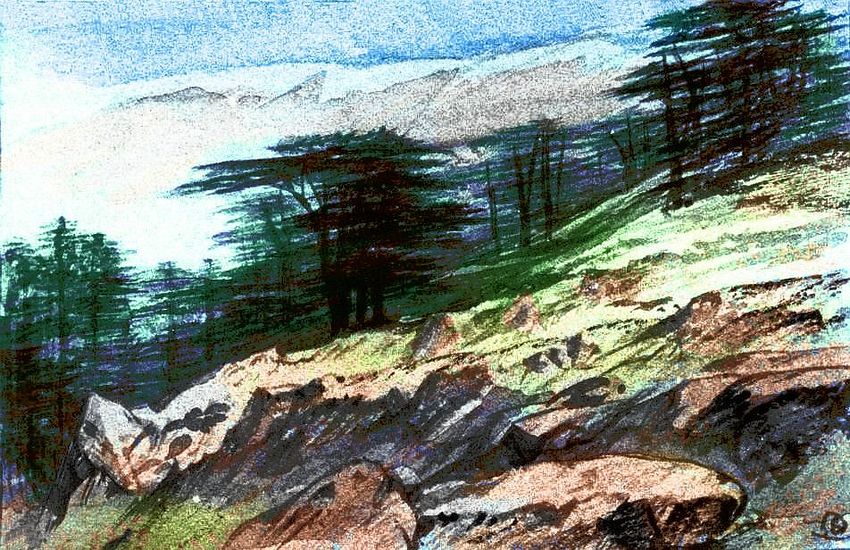
But we'll stop in Port Ula so you can get a look at the local forests. About ten feet of it, anyway. An overgrown green wall! This is true rainforest--the only such region on Tua.
From the Ulas on down, the east coast is called Nulara. The people here think of themselves as Nularans, not Tuans; the idea of a continent is abstract on Kakalea. The inland deserts don't unite, they divide; trade is easier by sea. So what matters is your coastal strip.
Northern Nulara is very fertile. Mild winters, hot muggy summers--punctuated with typhoons some years. Oh, well--into every life a little typhoon must fall. Beats drought, and that's all you'd get inland over the mountains. If you could get over the mountains! Icecapped Mt Serim tops 5500 meters (18,000'); even the lowest passes are 2500-3000 meters (8-10,000'); Kakalea's thinner air and higher gravity make pressure drop off to Himalayan levels in those passes. The locals are better adapted, of course, but even for them it's no fun; few caravans cross the Dividing Range.
This coast, like Australia's, looks seaward, to the rich isles of Suma and Tasa, not inland. Outback indeed!
Central Nulara, from Droi Port south: fewer tropical storms, but nearly as rainy and warm. The snowy spine of the Dividing Range recedes inland, a faint line of white teeth on the horizon. Green, green, green.
A week later we reach Lim Bay. The climate is much like Sidney--subtropical now, not tropical. But it's less prone to typhoons or drought, and these snowfed rivers don't fail even when the rains do. In warm country like this, snow is a reservoir needing no dam.
Droi Port and Lim Bay are huge cities by Kakalean standards--perhaps 100,000 people each, with several printing presses and of course many rival theaters. Pieces originating here tend to be urban, domestic, with less of the nature-worship you've no doubt noticed elsewhere. Vegetation is so exuberant and dense here that people sitick to cleared roads and paths, and can make do with a small yard for greens and fruit, allowing densities inconceivable in drier climates.
About cities: Kakaleans take up more space than humans--they're more horizontal, after all--but they also require more fruits & vegetables, so citydwellers generally insist on at least a small garden for favorites. But in Lim Bay this ecological footprint is smaller and the city more compact than most.
It's visible even in drama. Notice the dense feather/plant motifs on the floor and walls. Patterns laid on patterns. Fevered, claustrophobia. And nature's a backdrop here--the Green Wall around one's garden--of plants, projects, friends, lovers, contacts...
There's also a crazy energy along this coast that's not so Australian. Not just a Green Wall, but... an itch to go bouncing off the Green Wall... whatever walls you got.

South to Cape Tsomin: after the first couple of days, we're not in Oz any more! The mountains march back to the coast. The land looks Tasmanian at first, but then a stretch of New England woods--deciduous, with bright golds and reds in season. The icy peaks are far taller than anything in either New England or Tasmania.
Land appears out to sea. More wooded sloped below icecapped peaks . Doren Island, east and south of Cape Tsomin. Dark forests, snowy winters--often severe, especially the southern half of the island, where the Long Ice looms, a white beast on the horizon. A predatory beast; this icefield is big enough to generate foul weather of its own. Not that it's alone...
Orath is not Antarctic, but Greenlandic: grass and even a few low trees in sheltered valleys, though with icefields along the high jagged spine. Dry winds howl down from these much of the year. A harsh country--but not dead! Sia has several peninsulas like Orath reaching far enough north for life. Sians--and there are native Sians, or at least colonists going back generations--would look at Earth's Antarctica, whose lone, eponymous peninsula is too short to be a refuge for large land animals and plants, and utter that quintessentially Kakalean phrase, "Oh, well." For once it's Earth that had bad luck. Orath, and Sia as a whole, is, in a perverse, chilly way, blessed--irregular enough so at least some of its megafauna and flora have survived.
We round Cape Tsomin. Not "Oh, well" this time! Good luck for once. Reasonable weather for this region--the mountains of Doren shelter us a bit from the harsh winds off Sia, but among mariners, Cape Tsomin's still known for trouble.
We sail northwest. At first, dark forests climbing to pale meadows, windy scree and ice. Tall horns.
But after two days we've crept hundreds of km back toward light and warmth--and the mountains recede, too. By Shumak Bay, they seem mere hills along the shore compared to the rawboned giants looming over Doren Strait. Dark-forested, but snow only on the highest. Misty; summers mild but rainy. An Antipodean Scotland or southern Norway? Tasmania? Washington?
Due west now for several days along this milder shore: Rola, it's called. England? But a primeval England, with huge trees. Little ports behind barrier islands, sheltered from the relentless winds and surf rolling in from the Pole. The hills grow gentler, lower. In the valleys, the dark pines give way to greener broadleaves. Houses with roses.
By now you've notice how much Kakaleans vary in size, build, and especially fur. But the many patterns you see are by no means all natural. Dye is less painful and permanent than tattooing; nearly all Kakaleans indulge, at least at festivals, and many dye-jobs make no attempt to be naturalistic. Tuans, particularly those along this cooler, rainier south shore, where folks have time on their hands during the winter rains, get whimsical and sometimes baroque in decoration. Am I claiming climate shapes art? Yes, absolutely. Compare the gnarly intricacy of, say, Albrecht Dürer and British Columbian totempoles and Maori tattooing--all from climates rather like Rola.
Here's a very modest, minimal example--Archa, from Shumak Bay:

Archa in Diamonds are a Girl's Best Fur |

Archa in Diamonds; the pattern is dye |
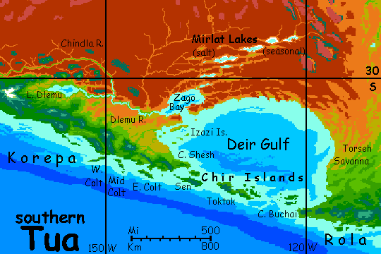
Two days along the Rola coast--little sounds, but generally west and a little north. But on the third day, suddenly a deep bay opens up. No... a strait. To the west, mere islands, the Chirrs. To the north, where you expect the heart of the Tuan continent, there's only sea! We've reached Cape Buchai, where Rola abruptly ends. As if rounding Land's End and heading north into the Irish Sea, we sail into Deir Gulf.
Deir could just as well be called a sea; it's bigger than our Black Sea, though shallower.
In the next four days, Deir's curving shore goes slowly from lush forest...
...to broadleaf groves and meadows, quite Mediterranean...
... to rolling grassland. Torseh Savanna's treeless ridges and marshy valleys run hundreds of km inland...
... to red scrubby desert.
Four more days west along this dry shore--mere villages, and few of those. No streams at all. Wells.
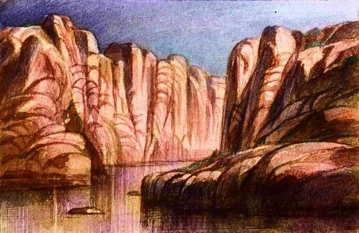
Into Zago Bay. Desert coast, the hottest you've felt yet. We anchor at the head, under red cliffs, where the Mirlat Lakes drain during rainy years (and don't, most years). A maze of canyons, brackish lakes and salt pans stretches at least 1000 km northeast.
Due north, it's different: orange monoliths stud plains of red dust; pale dunefields wander slowly over the waste.
In the afternoon, the sky turns a bruise-purple. And then disappears. Dust storm! Surrounds us even out here on the water. Irritating to the eyes, nose and lungs--but also, a dangerous red-out with visibility near zero. We anchor and wait.
Next day the stuff's settled and we can move on. Late that evening--very red sunset--we reach Port Dlemu. An actual town on an actual river! Haven't seen that in a thousand kilometers or two.
Let's take a side trip inland--no, not trekking, it's too hot. Our catamaran has shallow draft; we can sail up the Dlemu River to the lake. Admittedly, it's slow after the open sea.. At this time of year the winds are consistently off the mountains, blowing into the desert, whose heat makes the air rise. So we reach and run up the river, though some bends require tacking. But there are villages every few miles. Reeds and marshes and birds.
Mind the hexapodal hippos--as irritable as Earth's. Much the most dangerous thing on the river.
Lake Dlemu's existence looks miraculous here on the desert's edge, but it has a price: the Dlemu River and its tributary, the Chindla, collect all the back-side streams from the eastern Coast Range, so none of them head north across the desert. The Scablands hide no Niles.
Back down the river, an easier journey; slow but steady current and no rapids; the sail's just for headway.
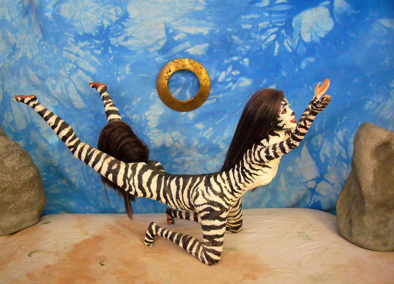
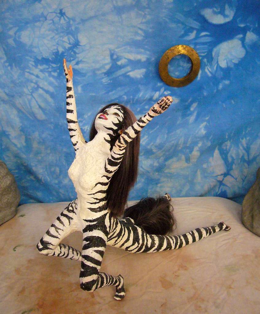
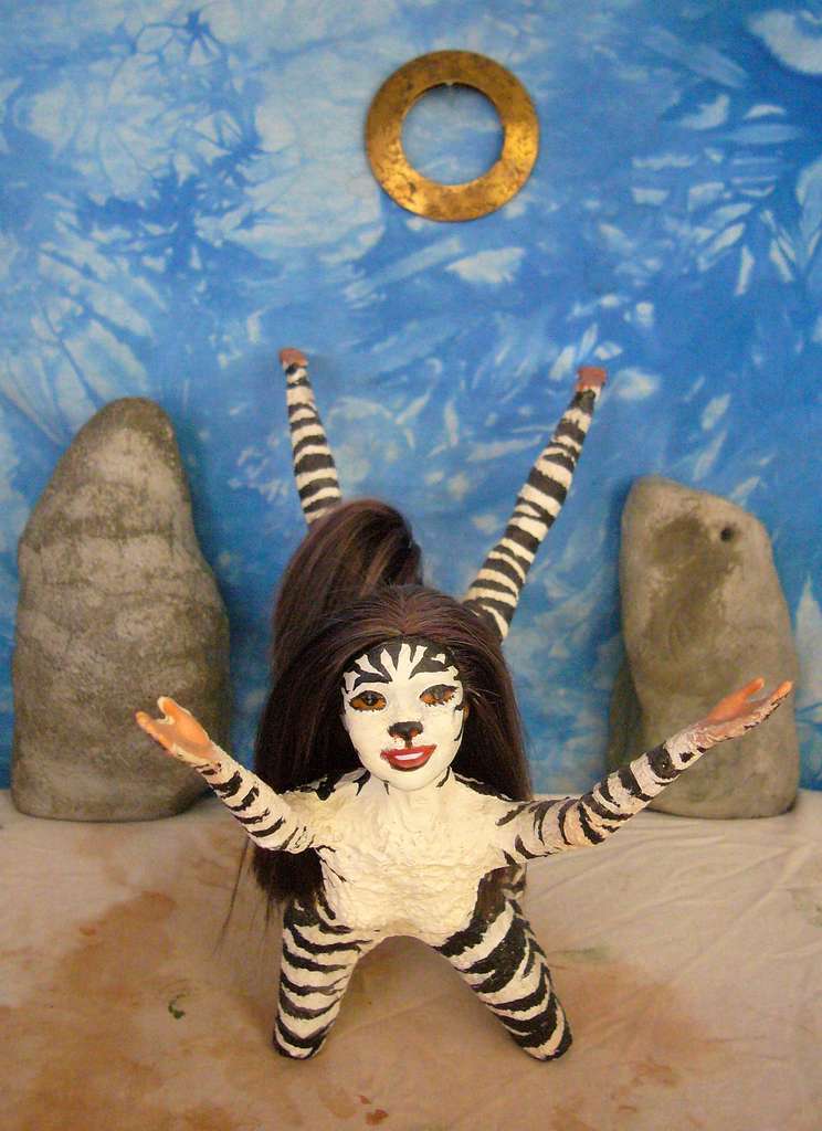
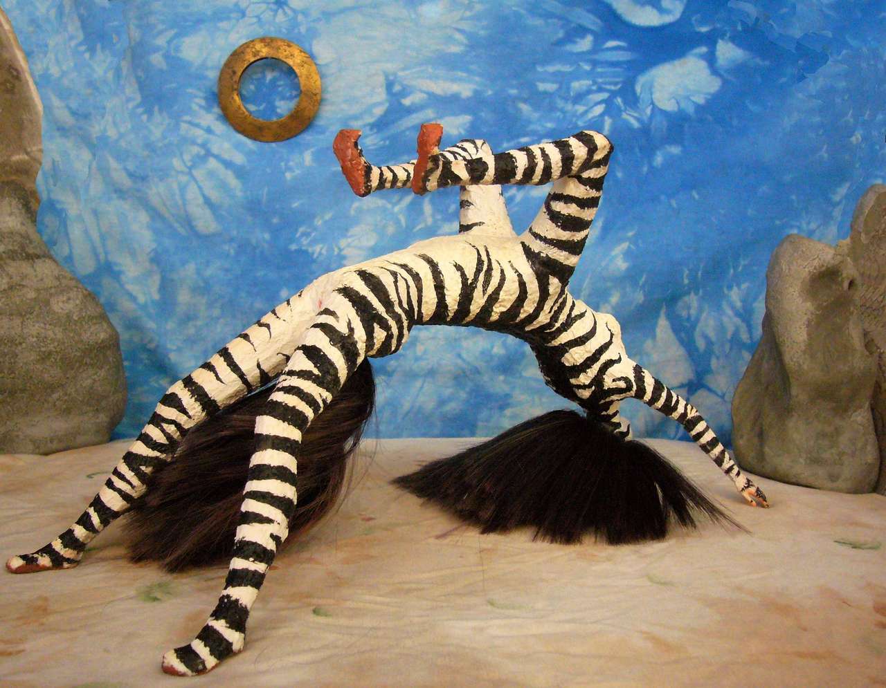
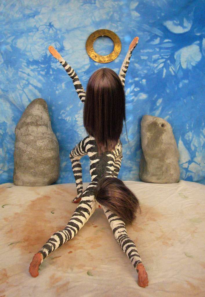
While here, in the only city of any size actually situated in Tua's desert, you follow your catamaran's crew to a cabaret and see a one-act musical starring a zebra. You've noticed them up and down the river--zebrataurs, I mean, not musicals, which are everywhere on Kakalea, of course. But zebroid coats are common only in Kakalea's hottest zones. The stripes have a purpose. On Terra, it was long believed they were camouflage--not so much for hiding in grass, the pattern's too bold, but it turns a herd into a confusing, undifferentiated mass to a charging lion. Not their chief purpose, it turns out. Zebra stripes do confuse predators--it's just that the lions are a bit smaller than we thought. Flies. The stripes are chemical-free bug repellent.
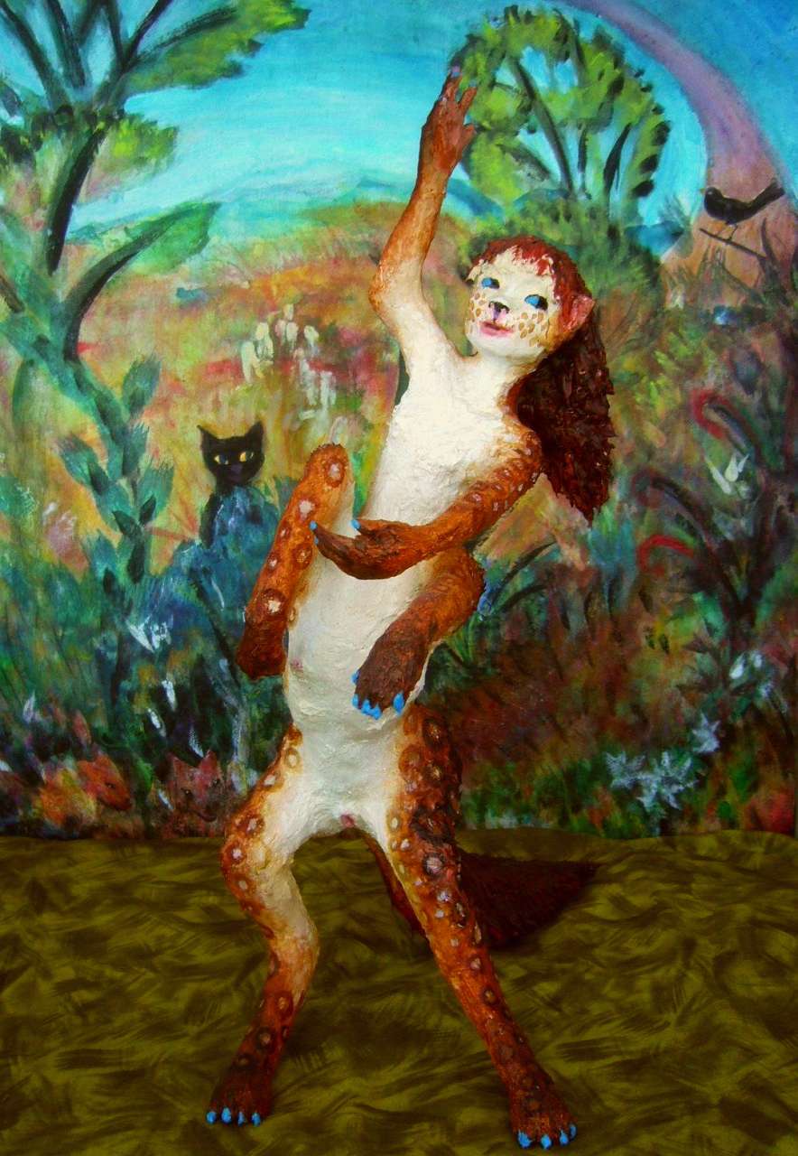
Anyway, here's Suplica in "The Brass Sun"...
| |||
|
|
|
|
| Suplica dances The Brass Sun in Port Dlemu, Tua | |||
Leaving Port Dlemu, you sail slowly south (not for the alliteration; here on the back side of the mountains winds are usually mild; a good thing, too. Remember that dust storm?) along Deir Gulf's west shore. Within a day, dry grass and brush anchor the red desert soil. Near sunset, scattered, wizened trees appear. By the next day, no longer wizened; the grass turns green.
Cape Shesh. Odd climate! Winter storms aren't fierce, but bring enough rain to tide trees over the summer drought. With sea in three directions, summer fogs sustain trees on seaward slopes even in the rare year when the winter rains fail. A hundred yards away it can be warm dry grassland. Hmm, hills and microclimates and fog.... No suspension bridges or cable cars though. But the latter are goofy enough for Kakalea--steampunk transit! Give them a few centuries...
But Port Shesh does have steam beer, cafes on every corner, and kooky performance art. Clearly these are climate-driven.
We sail west from Cape Shesh, along the mountainous southwest coast--Korepa, it's called. It's as narrow as Chile, but unlike that north-south strip from fierce desert to semiarid to Mediterranean to temperate to Nordic and then subarctic, Korepa runs only from cool green forests in the southeast--like Northern California, rising to icy peaks inland--to mild Mediterranean land of pseudoaks and meadows in the northwest. Just as on the east coast, the desert's cut off culturally, not just climatically--the mountain passes are so high the air's uncomfortably thin, even for the big-lunged natives; dangerous for you. Stick to the coast! Towns dot the shore at rivermouths; everyone looks to the sea. Korepans, like Nularans, don't think of themselves as Tuan. As far as they're concerned they're an island nation surrounded by seas--one of them just happens to be sand.
Eventually this section will expand--Korepa is, after all, home to half the biomass on Tua, and more than half the population (its mild climate is friendlier to intelligent life than the typhoons of Cape Diranu and Kserna or the blizzards of Cape Tsomin. The muggy Nulara Coast is its only real rival; and Korepa's twice as long). For now, just an outline:
The Chir Colts, long diagonal islands west of Cape Shesh, sheltering fair-sized ports on the inland side, though no great cities. Inland, farms below pine ridges and volcanic cones. Oregonian?
After a week we're just a third of the way along the Korepa Coast, navigating by the ice-capped volcanoes, each as distinct as a lighthouse, and a lot taller...
We'll halt and restock at the major port of Yaruu, with its twin harbors sheltered by a forked peninsula. Beautiful town. Eventually I'll sketch it for you.
Riraa of Khet in Spring Up!, a celebratory dance. Riraa DOES have spots, but what you see is mostly dye. |
A week later we pass Pshet Head and its sheltered bay--the last for some time. This is the Open Shore, a fertile strip but with only small, fairweather ports--the only safe anchorages in winter storms are in coves. As a result the Open Shore is culturally backward.
As we enter northwestern Korepa, it warms and dries a bit, becoming a classic Mediterranean strip. Pleasant country. Reminiscent of Perth and the Swan River, though more scenic--always that mountain backdrop.
Another week to the next big port--two-thirds of the way along the Coast. Turen Bay sneaks up on you--it's hidden behind a long peninsula. The sudden strait, the long oval sound whose hills are a patchwork of meadow and groves, all reminds you of San Francisco Bay--before industry and bridges, that is. No one's planning to bridge the Turen Gate; it's 8 km of deep water. Besides, Kakaleans aren't in a hurry, and they like to sail. The ferry's fast enough.
Another week. Small ports every evening--we have our pick. We'll stay a day or two in Khet Port, though, to sample the nightlife. Its sheltered bay means every ship pulls in for news and supplies. Khet is all the Open Coast is not.
Things are especially cheerful because the winter rains filled all the reservoirs and now spring is here; lots of celebratory and fertility dances, some of which would be illegal in most Earth jurisdictions.
Past Khet Bay, we're skirting the Keshe'a Peninsula, the west end of Korepa--and of Tua, that continent the Tuans deny.
Port Keshe'a, near the tip, is the jumping-off point for ships heading west along the Kshupa Islands, a chain leading to the Africa-sized continent of Ara.
Well, halfway. There's a 320-km gap halfway out (that's 200 mi wide); beyond it, the Arans call the chain the Dachei Islands. That gap isn't just cultural or political; biological too. On either side, the gaps are short, shallow and the next island always visible; primitives with rafts, and even vigorous swimmers could manage them (consider the feats of polar bears and elephants). But the Dachei Gap ensured that land animals on the two continents would be sharply different, just as Wallace's Line biologically divides east and west Indonesia.
Not all straits are equal.
Before you click on that link heading out to a non-pipsqueak continent, there's one more Tuan coast to see--the hardest, though also the wildest...
We book passage east, along Tua's north coast--the Dry Shore.
The first few days, it's not too bad; the decay is subtle. Slowly the hills recede to the horizon, and then beyond it, though rivers still wind down from their relatively rainy slopes--the Tsem, the Dzo, the Omak, the Pellu. The trees of Keshe'a grow sparse except along the rivers. Tuak Savanna continues, the grass tall and green to Port Omak; but nearing Pellu Town, it turns short and golden. The raw red cliffs of Wedge Island are a taste of what's to come. After Green River, the last major stream, the shore's nearly barren behind low cliffs. You climb the mast and can't see a thing inland--a brown plain fading to haze...
They're guardians who failed. Oh, there's still a town, still a river--the first in quite a while, and the last; the town's here for drinking water and because the canyon's a trade route, not just for the beauty of its site. But the Ghost River's small--drinkable, but not navigable by keeled craft.
There's a reason it's called the Ghost. Once it was the Dekela River. Its great canyon suggests a Nile; and the ruins on the bluffs, and for two miles upstream, show that until 7000 years ago Port Dekela was the great city of the north coast, unloading riverbarges laden with produce from a sunny, irrigated valley and the minerals from a great desert basin, much as the Egyptians used the Nile. But this Nile died--that's just its melancholy, muddy little ghost you're drinking.
What can kill a whole nation? The southern mountains still catch rain--they're tall and vigorous. Even if they tilted or thrust up new ridges, the river should just cut through them, maintaining its drainage basin. Erosion trumps uplift--the Grand Canyon proves that. So why did the Dekela die?
The great geologist Louis Agassiz emphasized gradualism--slow change over millions of years. He was correcting the catastrophism taught by the Bible; and he was right to. Geologic change generally happens in deep time, not human time.
But not always. The southern mountains flank an active trench--and volcanoes (like meteors and humans) now and then defy Agassism. Catastrophe queens! Eight thousand years ago, nearly due south of us, a line of young cones grew violently, further into the desert than was common for that stretch of the coastal range.
Lava flows blocked a dozen feeder streams and grew too quickly to be cut through. The new ridge, diverting the runoff from a broad fertile upland in Korepa, today feeds the Dlemu River heading east. The adjacent peaks in the southern range (not coincidentally; their youth is why they're still so tall) wall off storms from the desert; the Dekela depended on that snowmelt. In a single generation the river shrank to an eighth of its former flow.
The great canyon remains, and scattered villages still irrigate and farm its flat bottom; but today only small canoes and rafts can ride the Ghost's shallow rapids down, and must portage back upstream. Farewell, barges of jade and melons and myrrh...
So Port Dekela shrank, and gnawed on the bones of its past. Nice while it lasted!
Oh, well.
No lessons here for Vegas or Cairo or Karachi, of course.
The next day, having filled our watercasks (though they taste distinctly of Prehistoric Regret) we thread the sound back out to its broad mouth and anchor for the night.
At dawn we sail east. The desert coast! No mountains walling off the drylands here. Not even hills. No trees, not even much brush. Bare red plains for a week!
Then, along the north-central coast, monster sandstone monoliths rise. Bays, but not rivermouths; just gaps between Ulurus and Olgas. The strange scablands run inland beyond the horizon. Paradoxically, this bare-looking land is a little more habitable; the slot canyons between these huge rocks shelter sparse trees and intermittent creeks--dry now.
Tap another cask and hope the breeze holds. If we're becalmed long enough we'll have to trek upstream seeking a water hole. And it won't be the healthiest stuff.
Slowly, this desert coast curves north a bit. The red turns brown, orange, gold: dry savanna.
Miners roam these canyons and plains, chipping at canyon walls and searching streambeds for gems, crystals and nuggets of precious metals. Nothing large-scale--no navigable streams so it's hard to export ore, and insufficient fuel to refine ores on the spot and carry out only finished ingots. Still, a loner can make a good living here, sleeping off the heat of the day in caves or shady canyons, working dawn and dusk and by moonlight. And these canyons and monoliths, moonlit, acquire a certain battered beauty...
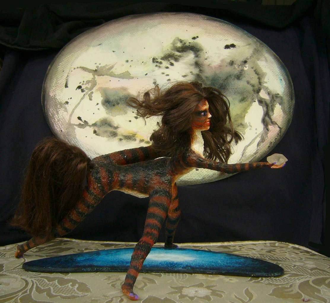
| |||

|

|
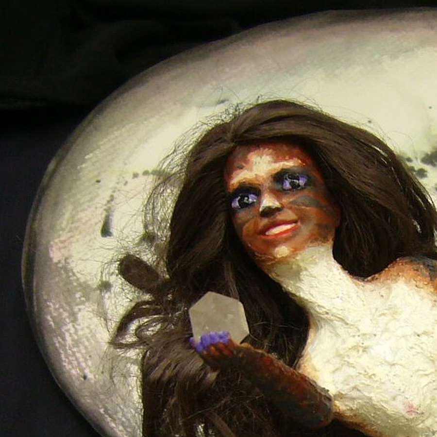
| |
| Lotora dances Snatch the Moon! in Port Kamrit, northern Tua | |||
As we sail northeast, over the next two days, the grassland greens a little. A scalloped coast. Head, crescent bay, head, bay...
At first these capes have little more than brush, but by the second day, scrubby trees cling to the rocks, feeding on fogs and sparse rains. Little marshes at creekmouths--small, sometimes brackish and always muddy, but the first freshwater reaching the sea since Dekela.
Across the mouth of one more bay, a big one this time--Kamrit Bay. Green grass along the shore, and the hills of its eastern side have groves of honest trees, right out in the open. A real port, too. You know it's a real port because it has two rival theaters.
It's a sign. We've left the desert. We're in civilization again...
...of a sort. The next day is long and dull, sailing off the shore of the Diranu Peninsula--monsoon forests and mangrove swamps. Some fishing villages, or so you're told. But the crew's reluctant to thread these sloughs--snags are common if you're not local. And not much to trade.
What's the region like? Dry winters, drenched summers. Bugs. That's the other reason the crew's happier to keep well out at sea. Not happy. Happier. Still plenty of biting flies even miles offshore. What do they live on when they can't get tourist?
The Prak Gulf--its south shore has lighter less reliable summer rains; swampy coastal woods full of bugs, rising to rocky scablands, wooded canyons, and savanna inland. Did I mention bugs?
Our pilots sensibly cut across Prak's mouth to Eria Island instead. Sea breezes drive evil bugs away! You stop getting swatted by centaur tails--as painful as being slapped with a towel. You thought those big showy tails were decorative or a sex-signaling thing like humans with Big Hair. Often, yes, but those are secondary uses. In pre-maritime days, walking Kakalea's endless deserts and savannas, a flyswatter was useful. For the owner. You've been slapped silly. Well, think of it as healthy exfoliation. You'd pay for it at a Terran spa. Maybe that'll take some of the sting out.
Through Eria Strait to Kserna Port, almost hidden in the green, green, green. Flowering vines. Butterflies not horseflies. True rainforest. After the Dry Coast it looks like paradise.
Well, full triangle. This is Tua.
LISTS AND LINKS: More worlds? Planetocopia! - dreams of other worlds - ecology - climate change - evolution - natural disasters - terraforming - sculptures and 3D art -
World Dream Bank homepage - Art gallery - New stuff - Introductory sampler, best dreams, best art - On dreamwork - Books
Indexes: Subject - Author - Date - Names - Places - Art media/styles
Titles: A - B - C - D - E - F - G - H - IJ - KL - M - NO - PQ - R - Sa-Sk - Sl-Sz - T - UV - WXYZ
Email: wdreamb@yahoo.com - Catalog of art, books, CDs - Behind the Curtain: FAQs, bio, site map - Kindred sites