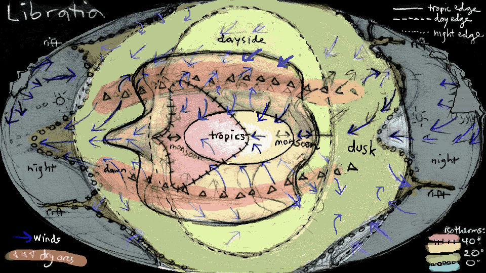
Libratia:
The Nightside
by Chris Wayan, 2011-12
for all you winged migrators
Libratia basics--map--
--solar system--tour the night--
More worlds? Planetocopia!
Libratia:
The Nightside
by Chris Wayan, 2011-12
for all you winged migrators
Libratia basics--map--
--solar system--tour the night--
More worlds? Planetocopia!
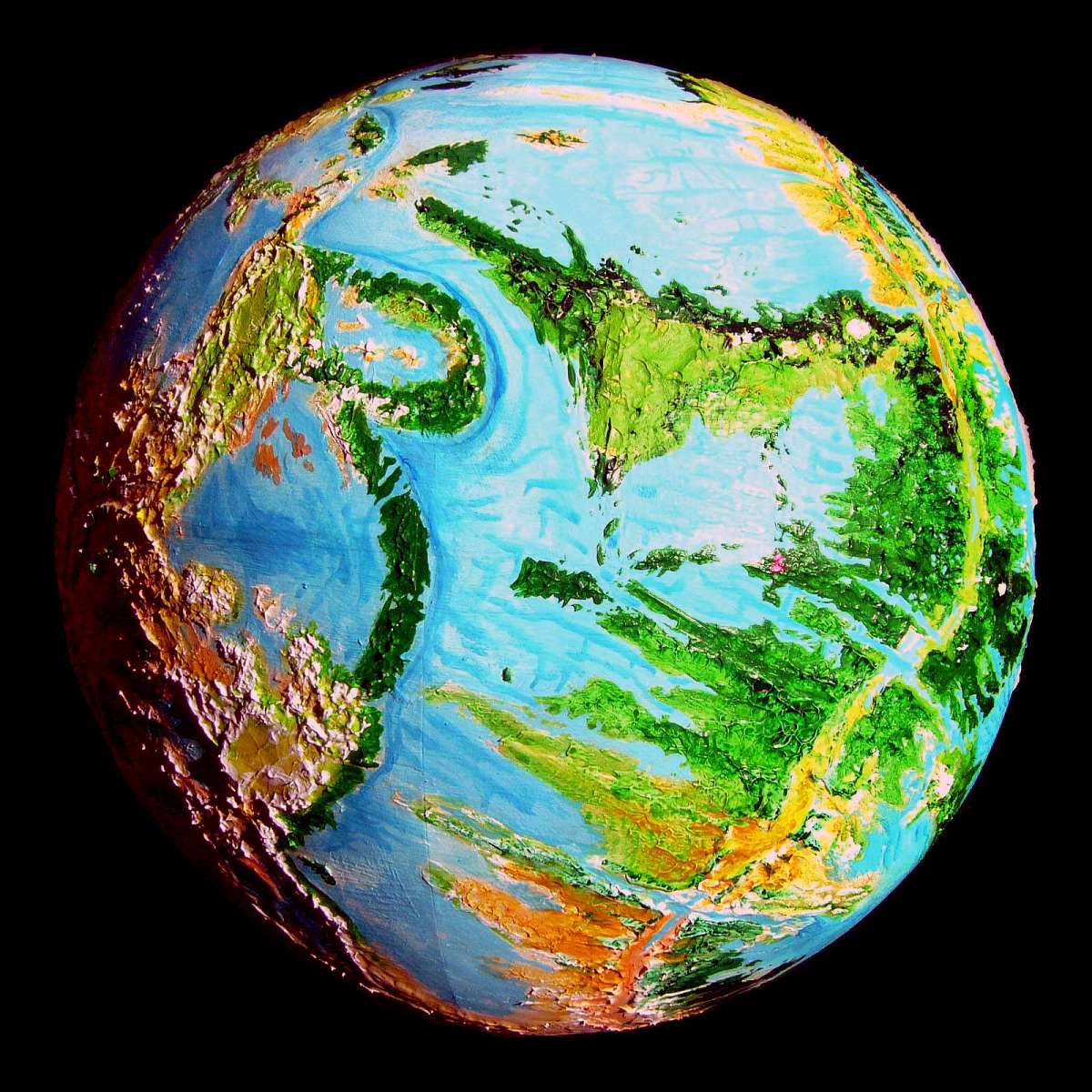
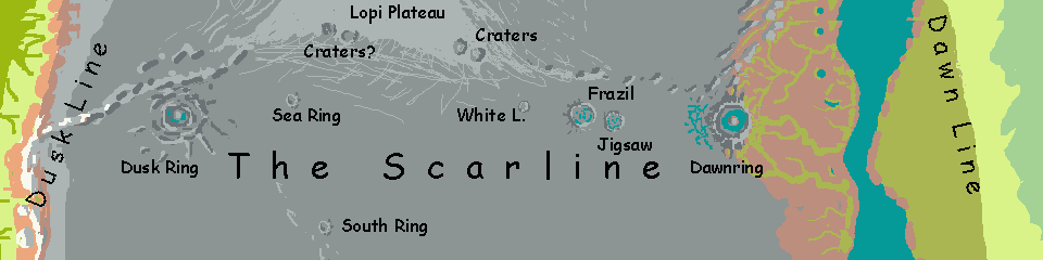
A track of huge impact craters crosses Libratia's nightside: the local name translates nicely as "the Scarline". Between the two largest rings--one in some of the pleasantest land the nightside can offer, the other among the deadliest places on the planet--stretches a chain of lesser impact craters over 10,000 km long (6250 mi).
I hope you're used to your strap-on wings; this won't be an easy flight. Most places on Libratia, you can find a sun-warmed updraft to carry you. Not here--it's relentless muscle work, and under harsh conditions. You'll be lucky to manage a few hours' flight between sleeps. Oh well, the exercise will keep you warm.
I hope.
DAWNRING
Let's begin around 20° north, on the eastern edge of night, called the Dawnline. Here the sun rises just as on Earth--just slower--then hovers an hour or two, changes its mind, and slowly sets again. This region's at the left edge of the orbital photo at right.
At this low latitude on the east side, it's quite warm--the prevailing winds blow in from daylit lands. So this low plain is grassy and dotted with pale flowers, even if the grass grows only intermittently. Small herds of grazers, though you'd never mistake them for Terran hayburners--lightly built, winged, with big eyes.
All "day"--several lors, the long local hours--you flap patiently over this pale green plain in the warm dusk-light. Slowly it dims to true night falls; the sun's swung away. We camp on the plain.
You sleep in, tired and sore from so much exertion, but "morning" never comes. We fly on under planetlight and a dim green glow behind us. After another hard day's night, a low shore hisses and murmurs below us. Land and camp.
The next "morning" almost is: the sun's swinging toward us again. We set out through a slowly brightening dawn, over islands wreathed in low fog, tattered by our tailwinds. Through the rents loom rocks and tussocks and vivid lime-green moss.
The strait's not wide. Another low shore, this one stonier, with sparser grass. Hills to the northeast--snowy hills. But the flats are still snow-free, with a little life.
Why? The atmosphere's so dense and humid it takes a good thousand kilometers for that day-air to cool enough for snow to march down from the shady side of the highest peaks to low hills like these; it still hasn't quite reached the plains and seas. A few days' flight south of us, along the equator, this sparse but living biozone stretches at least two thousand kilometers into the dusk--the Lifetongue.
Still, on our fourth day, a bright one, the sun as close to dawning as it ever gets here, it's merely cold, not freezing; as we near our first crater, the dawnward slopes still have sparse plantlife adapted to the dim light.
Before us is a ruddy mountain range--the east rim of Dawnring, second biggest crater on the planet, 480 km wide (nearly 300 mi) with ragged rays trailing off into the surrounding shallow seas. While direct sun never quite hits the lofty crater walls, it comes within a few degrees, so dawnlight here on the east face is bright. You can see full color, and there is color to see--low flowering plants at least, and in places small trees! Bonsai. Slow-growing, thousands of Earth years old.
Time to show me you really have mastered those strap-on wings: power up the slope! The tailwinds will help. Take your time--these are high mountains--but keep at it...
At last you crest a pass--not that it's much below the peaks around you. Snow on the ground, icy winds. Even this pass is 4 km up (over 13,000'). Before you is another world--a midnight-blue sea of shadow. Here, the planet's terminator is only a few feet wide: day behind you, night ahead. The firelit ridge curves off left and right. There's one great peak directly ahead, over the horizon, but you can't possibly be seeing the far rim, not even from this high up. Far below, patches of mist half-hide... a pewter plain of ice with black veins, then lanes of... open water!
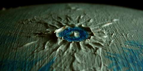
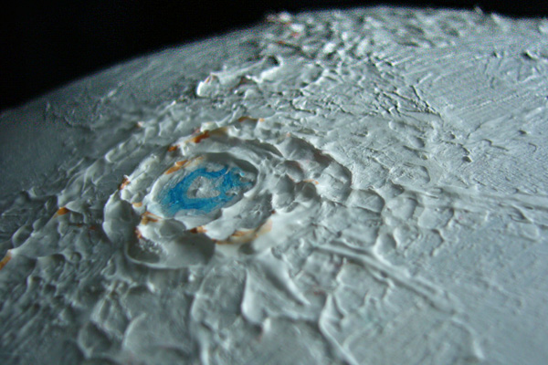
For Dawnring cups a deep circular lake nearly 400 km wide (250 mi). That peak over the horizon, 6 km high (20,000') is a central island, presumably the impact point. Only halfway across!
Here in the crater's shadow, still cold air pools; it's generally below freezing down there in the dark. Yet the lake is mostly ice-free. Why? Lake Dawn is so deep that, like Siberia's Lake Baikal, its bed is quite warm at the bottom; convection melts any surface ice that forms.
The warm winds from the dayside blow the lake-generated fogs west, deeper into the nightside, so the east shore of the lake can often be reached in relative safety. Elsewhere, it's not so patchy. Shorebirds nest here and feed on the lake's creatures--and whether these top out at brine shrimp or belugas, I'm not sure yet. Plenty of nutrients here, from guano if nothing else. Photosynthesis of algae in the lake is slow in the dim light, but it's a big, big lake... Let's just say you shouldn't stick your toes in the water.
In fact, let's stay up here in the light, and follow the rim round, right or left. You choose. For the first third of the journey it's an effortless break--the winds rise against the rim, and you ride the updrafts like a condor for a couple of hours. Then the winds run parallel to the ridge, giving you a tailwind, but less lift. You're exhausted by the time we camp--our first snow camp. Not "in the morning"--there is no morning here, nor ever will be--just whenever you wake, you set out around the final third of the way. You swing out over the lake-facing inner slope now, to catch what updrafts you can; the outer wall now has treacherous downdrafts. You float in ember-light, color slowly fading, over a sea of dark fog on a chill, clammy breeze. Not pleasant.
At last the rim's curved near enough to north-south to be worthless for our westward journey; time to say goodbye to Dawnring. Down the slope you dive, into deep blue night. Paler humps of cloud crowd round you like buffalo in a blizzard. Through clear gaps you dimly see that snow now reaches to the mountains' feet, and out beyond. There's sea out there, but pale floes crowd it; mere black lanes. Frost at sea level! End of the life zone.
You camp on the shore, amid rocks. The last you'll see in a while. In the morning you set out over the ice-choked sea. Soon it's a cracked ice plain, then a smooth one... Ice camping from here on in.
CRATERS OF THE ICE SEA
How dark is the true nightside, past dawn or dusk? Brighter than you'd think for a world lacking a moon. Libratia's sister planets are very close, almost at lunar distances; four of them have visible disks and shine much brighter than Venus; usually comparable to a crescent moon, not mere starlight. Here's a sketch with all of them up at once (unlikely!). When several do share the sky on a clear night, it's dimmer than full moonlight on Earth (the sky stays black not midnight-blue), but there are fewer deep shadows, since the lights are multiple.
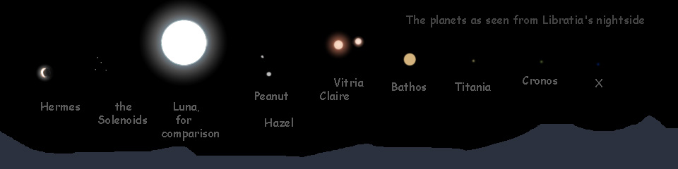
Well, greenward. On Earth, after the red sunset comes a brief green twilight, then a long blue. Libratia's red sun and ruddy planets extend the green and mute the blue.
So it's a fitful journey over the ice plain for three or four sleeps. Fly till exhausted, threading between cloud-banners, land on the ice (the most hazardous moment of the day, er, night), make camp, eat, sleep, pack up, fly till exhausted...
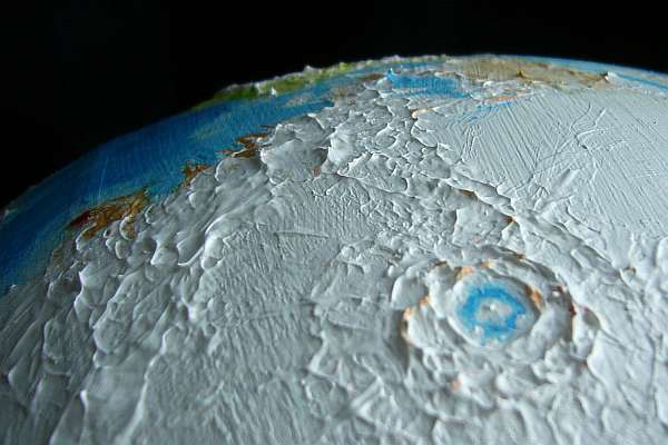
For the next crater lies fully 1000 km west of Lake Dawn. At last, arcuate islands rise from the ice-covered sea in a wall horizon to horizon--the leading edge of a ring 125 km wide (75 mi). After Dawnring, its easily visible curvature makes it seem almost small.
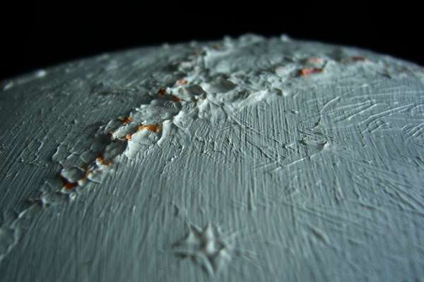
While this crater's also deep enough to warm the lake so the ice is thin and fractured, only fissures of open water vein the lakeface. Hence its name, Oro Shisha-kik; in translation, Lake Jigsaw.
From Jigsaw Crater's western ridges, on a clear day (still a sometime thing, downwind of Lake Dawnring. Banners and tongues of low cloud writhe across the ice plain, greenish in the twilight) you can see a range of hills walling off the western horizon. This is a third crater, Jigsaw's big brother, Frazil, 200 km across (125 mi). Though larger overall, Frazil's ridges are lower and somewhat broken--rather than an iced-over lake it's an iced-over bay. In the dim light, its few deep blue veins of open water seem black.
For 1200 km west of Frazil, the ice plain is unbroken. Slowly the green turns blue and dims to true night. Yet the air is still around -5°C. Even 3000 km inside the night, a coat and steady exercise is all you need to stay warm. This is the tropical nightside!
You feel like you're dreaming. You won a free pass to Godzilla's ice rink and now you can't find the exit...
At last low ridges rise from the ice. They seem parallel, meeting at infinity straight ahead. But they're really concentric rays; they do meet on the horizon, on a low ridge--the rim of the smallest crater yet, only 40 km across (still respectable by Earth standards: 25 mi). This one's small enough so the bottom's barely a kilometer down; not enough convection-heat for open water. The ice is thin but unbroken. Oro Kiru: Lake White.
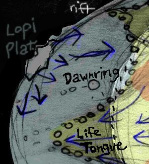
LOPI PLATEAU
West of White Crater, the rays never settle back into a smooth sea. Low ice-ridges pile up, and the wind, up till now mild, and at your back, shifts to a steady dry blast in your face. You're nearing Lopi, the triangular highland at the heart of the darkside. Like Antarctica, it sheds cold winds off its glaciers.
To see the next crater-cluster, you have to climb Lopi's frozen coastal mountains to the glacial cap beyond. Here, twin rings of rock rise as nunataks, bare ice-gnawed spires, islands in an ice sea miles thick. Perhaps 200 km wide each, little is known about these continental monsters.
There are definitely more, strung along the south coast of Lopi--two likelies to the west, nestled amid high peaks, are nearly as big as the twin giants, though this country's so deadly and dark it's hard to be sure they're impact features.
It's not chance that Lopi, the largest icecap on the nightside (perhaps half the total volume), is so close to the midnight pole. It's here because the land under it moved here. On the dayside, too, there's a concentration of land around the noon pole. As Libratia slowed and eventually swung to a (near) halt, billions of years ago, concentrations of mass gravitated toward these poles for tidal reasons (the long axis or the heaviest bits like to line up with the sun); this configuration is close to the best fit, at least for now. Libratian "continents" are heavier than Earth's--double-thick stacks of basaltic sea-bottom strata, not rafts of lighter rock floating on the heavy stuff. They're true 'mascons', and act as magnets gravitating toward noon and midnight. As plates move and continents drift, the poles may too; Libratia turns under its sheet of sunlight and blanket of ice like an uneasy sleeper.
A smaller but clear and unmistakable ring, Sea Crater, rises from this fissured ice plain. You're tired now, and the light's so dim it's just another obstacle to get over.
South Ring isn't exactly next. It's well off the Scarline--some 2400 km (1500 mi) due south of Sea Crater, in low, glaciated hills. It's controversial--a definite impact ring a good 200 km (125 mi) across, but way out of place. Is it just a stray mountain from the comet creating the Scarline, or an unrelated impact eons earlier or later than the chain?
It could be. Libratia's nightside seas, ice-sealed but largely glacierless--starved for snow, in fact--preserve ancient features better than the dayside, with its constant erosive rains.
But I wouldn't generalize from Libratia. Deeper seas wouldn't form visible craters at all. And a nightside with more land might support a hemispheric Antarctica--the classic fire-and-ice cliché for tidelocked worlds. Deep ice, (especially moving glaciers) would gnaw craters fast! But on Libratia's nightside, for now, change is slow... except on the ice-domes over land, like Lopi, and right at the waterline.
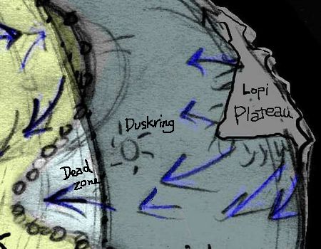
DUSKRING
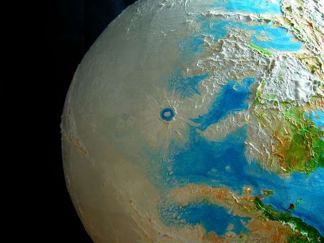
From Sea Crater it's still 1800 km of sea ice and ray-ridges west to the last and largest crater in the chain: Duskring. The journey is cold and dull at first, but a slow blue glow ahead brightens to that unique dim Libratian green: you're nearing the duskside at last.
The orbital photo to the left looks back from Duskring over the beat-up ice toward Sea Crater and the Lopi Plateau. It'd be a nightmare crossing this wingless. Be glad you're a temporary bird.
Duskring Crater is the biggest in the world--a rayed, double-walled structure nearly 1000 km (600 mi) across. Better yet, you get to see the spectacle--black jagged fangs silhouetted against the dull glow in the west--bronze now, brightening to gold. It's a hard climb up the wall, but you've toughened up by now--and lost, I suspect, a lot of weight.
Topping the outer ringwall at last, you're disappointed. Just a great valley of shadow. But you make camp on the sheltered western side of the ridge, and try to sleep in that sullen light--the first real color in a month!
When you wake, it takes hours to cross that dark valley to the inner wall. By the time you crest that one and stand in ruddy light (not direct sun; we're still days away from that!) you're exhausted again. You set up camp, then sightsee. Below, a pool of shadow--the last outlier of the night you're leaving behind--gleams fitfully. Sunset reflected on open water! The inner crater cups a lake 250 km across (150 mi). It has a broad lane or ring of open water between ice shelves on its shores and the central island. Those streaks of light are the first break in the ice you've seen in weeks.
Unlike Dawnring's broad stretches of open water, these bands of light are narrow. Yet Duskring is bigger, its lakefloor gouged deeper--and hotter. Why's the lake mostly frozen? The prevailing winds here are off the night plains, and much colder.
What open water there is, steams into dry frigid air. From that fuming ring, a plume of dense, cold fog blows west all the way into the eveside ahead of us. Reaching Duskring at all from the west is dangerous--and of course most explorers came from there, it's by far the shortest route. The inner crater, especially the sunward, downwind shore, is often fogged in. Thick, black, blind and starless, unsurveyable, unnavigable. Fatally so: since the crater was first spotted centuries ago, the Libratian expression for suicidal recklessness is "s/he wants to plumb Lake Duskring."
We'll skirt the death fog--follow the south side of the rim until the fog starts to spill out ahead of us like a boiling pot, forced by the westbound wind. Ahead the ridge, our highway, vanishes into fuming dark. Time for us to to leave! Turn southwest, zooming down the great slope, then parallel the fog-streamers from a safe distance.
A DEAD TONGUE
It's still 1600 km west, over a fractured, still frozen sea, through slowly brightening sunset light, gold orange and red, to the edge of day. Tattered black mists from Lake Duskring follow you on the northern horizon, unwelcome companions on your journey; riding the same winds you do.
At least that chill wind's at your back, not in your face. Speeds us along. But they're also why you're so close to sunrise and still crossing a snowy plain; prevailing winds keep this limb much colder. For several lors a day, the plain below already has enough light for plants--it's just too cold. Patchy snow and bare ground, mostly; grass only in sheltered, west-facing spots, right up to the verge of the sunlands. Here, the wind isn't that strong--they seldom are at Latitude 15-20, and we're thousands of km now away from Lopi, that katabatic wind-generator. Not far south of us, along the equator, the winds are steadier; there, a tongue of wind-chilled frozen land actually pokes into the sun--a second dead zone, less dangerous for fliers than the black fogs north of us, but still virtually uninhabited, for it's essentially foodless.
My point? As always, it's that the dark side isn't a vast undifferentiated waste. Light, temperature and humidity all vary--and all matter. Not all darkness, not all cold, is unendurable. But north and south of us right now are bad for life--though for two quite different reasons. The strip we're following, sterile though it looks, wasn't an idle choice. It leads quickest to back into life, not just light. Easy to equate them, but they're not the same--not quite.
THAT WESTERN SUNRISE
At last the sun rises--in the west. A sight you don't often see! Directions are, after all, conventions; exocartographers routinely assign north, south, east and west so as to make the sun rise in the east and set in the west. Venus is the only exception I know--next door to Earth, and slowly spinning retrograde. But at least it spins. On Libratia, no cartographic convention can normalize the sun's behavior.
You'll probably find that first red flash of sun blinding, though it's no fiercer than a campfire; you've been in the dark far too long. Native explorers, being better fliers, cross the night faster than you do, of course, but even they take a few weeks; it's 14,000 km (9,000 mi)! If you tried it Earth style, on foot or by dogsled, you'd starve like Scott; the trip would take a year or more. No one could carry enough food. Or sanity. You'd run out of one or the other.
All in all, not an easy way to spend a vacation!
So congratulations. You've done what Scott died trying to do, and more--crossed not a mere continent but a whole dark hemisphere, and come out alive. If gaunt. Of course, you had an advantage: dense air let you fly over obstacles and move fast, keeping your trip-time short and your supplies light.
Two paths shorter and safer than the Scarline cross the nightside too:
SOUTH RIFT
South Rift crosses the nightside east-west, around 35° south. This crustal spreading zone is long, sinuous and broken, as you can see from the orbital photo below (a time-exposure, obviously; even at its best, it isn't nearly this light.) You'll find volcanoes, hot springs, long narrow ice-free mineral lakes and bare earth down much of the rift floor. Deep ice does mantle the outer ridge-slopes, but glaciers flowing into the rift are melted short. This southern route has a great advantage: farther from the icecap of Lopi, yet still deep into the nightside, its weather is predictable: either cold-but-clear or icy fogs from the lake. No blizzards after the first couple of sleeps.
Its great disadvantage is that it's not smooth sea-ice, like most of the Scarline. The Rift is quite rugged. You'll cross icy ridges and tongues. Even by air it's got some tiring climbs, limiting the size of trade items carried. Even if Libratians have the technology, no highway or railroad could be laid down, for the nightside glaciers, though slow, would shatter them in months. Ice never stops. So it's a route fit only for fliers--and what little they can carry.
Some of these lakes are warm; a few are hot. Many are mineral-rich stews. The result? Vent colonies including quite large, complex life based on chemical energy, not photosynthesis, quite like those in Earth's deep seas... only these are often at the surface! The fishing isn't dull, though it's hard to see what you've caught. And you need to be sure before you consider eating it. As with mushrooms, quite a few are toxic. Not just to alien tourists--ancient native explorers quickly learned that the adaptations to high temperatures and the weird mineral salts made some of these lake colonies poisonous and many of the rest awful-tasting.
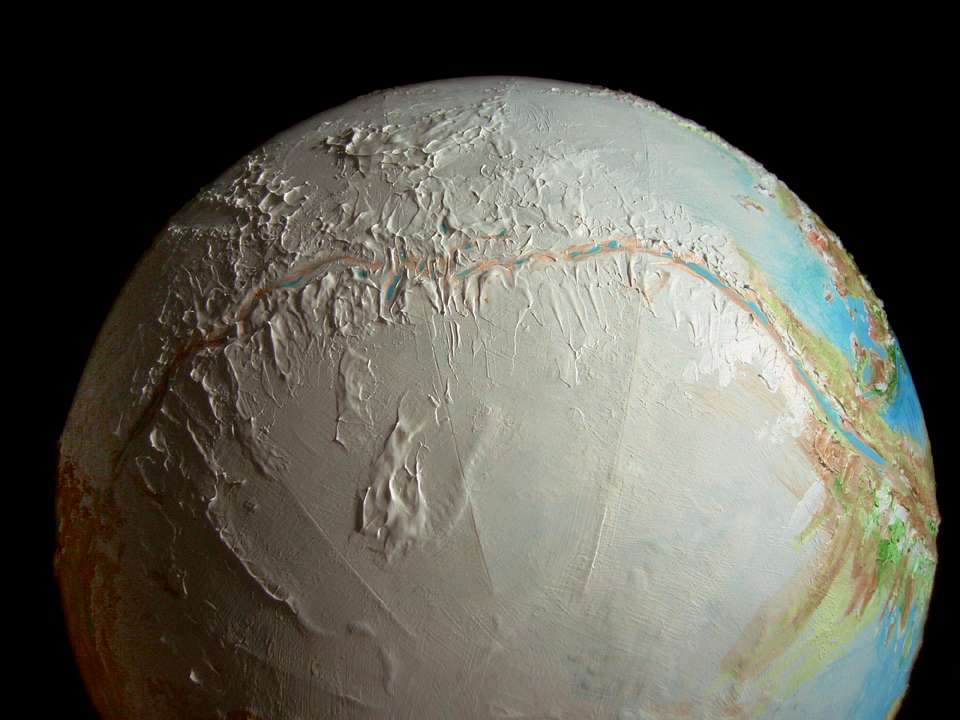
Because South Rift cuts across the night well past the storms of the border into the central zone of cold, clear skies, it has Libratia's best combination of excellent seeing and feasible supply lines--if only just feasible. So one of the way-shelters in the middle of the route is much more elaborate than usual: a small observatory! Three modest scopes and a few shivering astronomers. But scholars all over Libratia vie for the chance to shiver, in exchange for scope-time. Travelers drop off food and supplies, and carry out data.
NORTH RIFT
The North Rift crosses east-west at about 60° north. It looks much like the southern rift, but it's much shorter and continuously ice-free, allowing surface travel and trade in heavy goods. You could build a railroad if you were that sort of 19th Century person.
So you'd think the North Rift would be much traveled, yes? But in fact it's lonelier than the longer southern route! At that high latitude, and nearer to Lopi, North Rift's both colder and prone to blizzards. Paradoxically, though it's nearer the edge of the nightside, which only reaches to 78° north, that borderzone sees fouler weather than South Rift or the Scarline, both routes plunging through the heart of the dark.
Plus, the northern route's just less useful. Why thread your way through an Antarctic dry valley (well, wet stinky valley) for weeks, with all its hardships, when it roughly parallels the edge of the ice? Stay on the dayside! Warmer, lighter, and just plain easier (if a bit longer) to just go round.
Which may have been the wise thing to do with the whole nightside: skip it. But since it's one of the least Terran sides of Libratia, I did want to give you a sense of it. Cold toes or not.
Libratia basics--map--solar system--tour the night--
LISTS AND LINKS: More worlds? Planetocopia! - dreams of other worlds - ecology - climate change - evolution - natural disasters - terraforming - sculptures and 3D art -
World Dream Bank homepage - Art gallery - New stuff - Introductory sampler, best dreams, best art - On dreamwork - Books
Indexes: Subject - Author - Date - Names - Places - Art media/styles
Titles: A - B - C - D - E - F - G - H - IJ - KL - M - NO - PQ - R - Sa-Sk - Sl-Sz - T - UV - WXYZ
Email: wdreamb@yahoo.com - Catalog of art, books, CDs - Behind the Curtain: FAQs, bio, site map - Kindred sites