
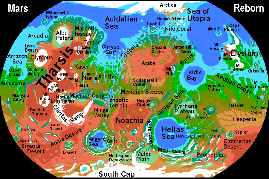
MARINER DELTA and CHRYSE GULF
by Chris Wayan, 2003
Mars Reborn: homepage -- Index: Martian place names -- Planetocopia: more world-models
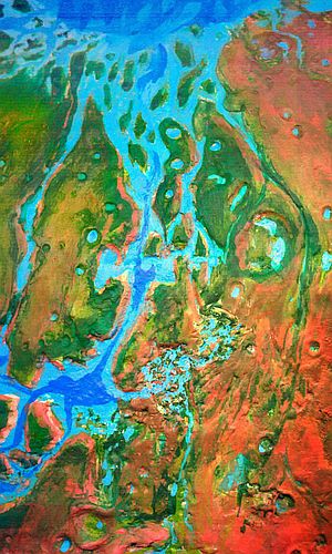
The lower reaches of the Mariner complex are, well, complex. Heading north against the current (due to evaporation, water flows south into Mariner Canyon, not north as a naive Terran might expect), we still have a thousand miles of canyons, islands and gulfs before we reach open sea. The main channel is Simud Sound, but it's intricately braided with the winding Tiu Sound to the east.
Kim Stanley Robinson describes this region as the most Earthlike part of Mars--green and mild. I've depicted it a bit drier--yes, Chryse Gulf will send storms over these lands, but to the east is 6000 km of desert, and to the west is Tharsis, whose heights wring all moisture from the winds that make it over the great wall.
On the other hand, maybe I'm wrong: the mesas and cliffs lining the sounds cause powerful updrafts, so thunderstorms are likely year-round. In any case these isles will be spectacular, with warm sun, blue gulfs and immense red cliffs, still over a mile high in many places.
Gradually the islands shrink and streamline, looking like tadpoles, broad-headed and slim-tailed. The channels broaden and the cliffs lower to a mere thousand feet or two, then become mere slopes, where the ancient floods swept right over them. At last the islands become sea-level lozenges, then reefs... and we're in the open sea of Chryse Gulf.
This round blue eye is probably an old impact basin. Kim Stanley Robinson and most other writers and cartographers show it even rounder, with a great cape jutting west from the desert coast of Cydonia, nearly making Chryse Gulf a separate sea.
But based on the more recent topo maps I've seen and the slightly higher sea level I've chosen, the cape would be a mere stretch of shallows and reefs, and Chryse would be as I've shown it--just a great tongue of the North Sea.
Endless lens-shaped islands, reefs and seamounts fill the southern half--the ghosts of mesas worn into mere grave-mounds by the floods that cut Mariner Canyon. They continue, deeper and deeper, much of the way to the Acidalian abyssal plain.
|
|
World Dream Bank homepage - Art gallery - New stuff - Introductory sampler, best dreams, best art - On dreamwork - Books
Indexes: Subject - Author - Date - Names - Places - Art media/styles
Titles: A - B - C - D - E - F - G - H - IJ - KL - M - NO - PQ - R - Sa-Sk - Sl-Sz - T - UV - WXYZ
Email: wdreamb@yahoo.com - Catalog of art, books, CDs - Behind the Curtain: FAQs, bio, site map - Kindred sites