
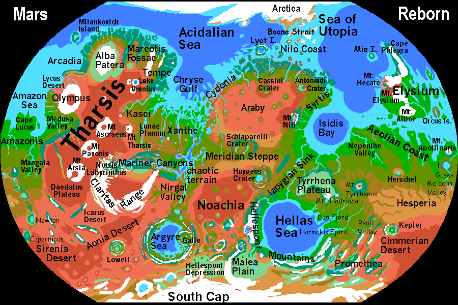
ISIDIS GULF REGION
by Chris Wayan, 2003
Mars Reborn: homepage -- Index: Martian place names -- Planetocopia: more world-models
Syrtis, the great dark hope of the telescopic astronomers, was a bust when we got a closer look--the seasonal darkness was wind-scoured, dust-free soil, not vegetation blooming and dying in a rainy season.
But now, after terraforming, Syrtis is finally as fertile as they dreamed--at least along the coast, where storms off Isidis Bay and the North Sea feed quite Terran-looking subtropical forests. Unfortunately, not far inland, a broad shoulders of a shield volcano called the Nili Patera traps much of the rain in a narrow coastal strip. Nili's a mere speedbump by Martian standards, just two or three kilometers high (8-9000'), but hundreds of kilometers across. Inland, sparse pine forests semi-cover the dark lava plateau dropping slowly into the Arabian desert.
That desert has good-sized oases--Antoniadi and its sister craters--but most of inland Syrtis is dry and hot--on the black lava, the heat can actually become uncomfortable. Surely a first for Mars! I've marked Nili's summit (well, crater-edge) with seasonal snow, more for visibility than plausibility--rain is much more likely, for we're not far from the equator, and Nili is just not that high. Let's call it a freak blizzard off the Utopian Sea to the north. If you're cold, you can always drop into Nili's caldera itself, where a warm lake sprawls in the subtropical sun. So do thousands of vacationers who find it a pleasant resort.
In the north, away from Nili Patera, the Syrtis coast resembles the Nilo Mesas to the west--a jagged coast with cliffy islands topped in broadleaf forests turning red and gold in fall, and inland, short rivers between similar mesas, rising to an escarpment, and then pine-forest plateaus stretching hundreds of miles inland, to the Antoniadi Lakes in their overlapping craters. This is temperate country, snowy and sometimes stormy in winter, warm and even a bit muggy in summer--think New England with redrock mesas.
This gulf, an old impact basin like Hellas and Chryse, has some of the most fertile coasts on Mars. This sheltered equatorial basin generates heavy rains all round. Narrow ribbons of coral reef hug the shore. They're spreading further offshore, since the slopes are shallow. Given a few more thousand years, they may rival Australia's Barrier Reef. But coral takes time.
The islets at the south end of Isidis, the Burroughs Reefs, may not be topographically justified--I've kept them there as a monument to the flooded first capital of Robinson's "Red Mars." At the sea level I've set, they may be no more than coral banks. In any case, Edgar Rice Burroughs has another monument now--a crater in the southern highlands (in Promethea, southeast of Hellas) a good 160 km across (100 mi).
From the east end of Isidis Bay, a wide, flat river plain cuts deep into the Southern Highlands. Nepenthe Valley is a warm rainforest bounded by great cliffs. Along the coast to the east, too, the land is absolutely lush. Unlike most of the Great Escarpment girdling Mars, the cliffs here can't fully block the dense tropical rains, which come from west and northeast (and occasionally even from Hellas, 1000 miles south). So this plateau, geologically part of the Southern Highlands, sustains open forest and savanna for hundreds of kilometers south. Substantial rivers flow north to leap off the Escarpment in spectacular falls higher than Angel. Guyana writ large!
Iapygia, the green strip at lower left, is a trough between two highlands--the Tyrrhena Plateau to the east, and the high Noachian Desert to the west. If you can't pronounce Iapygia, rejoice--a recent National Geographic map has banished its embarrassing hint of piggery and renamed it Oenotria. (Blending 'oenophilia' and 'nutria', it means, to translate from the Greek, Land of Wine-Drunk Hamsters. Much more dignified. Gotta love nomenclature committees!)
The Iapygian Trough (sorry, I'm sticking with Kim Stanley Robinson. "I, a pigeon"--now, was that any harder than "I, Claudius"?) links Isidis Bay and the Hellas Sea to the south. Isidis, especially, sends storms down through Iapygia each summer--a weak monsoon. Add to this the runoff from the Tyrrhena Highlands to the east, and you get an unusually wet non-coastal region. Not surprising, with sea both north and south of it.
In the north, coastal hills (the Libya Montes) limit drainage into Isidis Bay; so I'm pretty sure most of Iapygia's rainfall drains south. But does it collect and dead-end in marshes or
craterlakes, or drain down rivers (few ancient channels to suggest this) or make its way underground to the much lower Hellas basin? I expect Iapygia to have forest in the north and south, near the coasts, and more open terrain inland--but depending on rainfall and drainage, it could be marsh, savanna, or prairie with lakes and groves.
Stay tuned for about 200 years and I'll let you know.
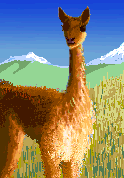
Tyrrhena is the highest plateau on Mars after Tharsis and central Elysium--four kilometers above North Sea Level (over 13,000'), and nearly ten above the Hellas Sea to the south (c. 32,000'!) Since Martian air is thin but oxygen-rich and drops off more slowly in the low gravity, Earth tourists in good shape will breathe just fine--it's Aspen or Nairobi, not Tibet. Still, Tyrrhena's sheer height will force much of the rain off Isidis Bay and Hellas to fall on the rims, feeding dense forests, but leaving the top of the plateau relatively open--snowy heights with just wind-scoured licheny rocks above alpine meadows. A few trees may survive in sheltered spots. I could be wrong--Mexico's northwest highlands are at a similar air-altitude and latitude--but Mars gets less sun. Terraforming can't work magic.
Tibetan antelope or, better yet, llamas and their kin (already highly intelligent, and after genetic tweaking, probably sentient) may be the dominant life-form here.
Southeast Tyrrhena is dotted with volcanoes--Hadriaca, Ausonia. Mt Tyrrhenus, which you'd expect to crown this highland, stands free of it a few hundred km to the east--its own little highland. The valley between, not nearly as low, distinct or rainy as the Iapygian Trough (more deserts upwind) doesn't seem to have a name. We'll dub it Kamativi Trough after its only prominent feature--a wide but shallow crater cupping extensive marshes.
South-central Tyrrhena is much lower, a sort of bay in the plateau wall. Storms drop their rain-burden on the heights and outer slopes, so this valley is drier than the rest of the plateau--a warm, treeless savanna something like our Ngorongoro Crater, but two hundred kilometers across.
Further south, scattered trees clump into open subtropical forests as the land drops steadily toward Hellas. And drops. And keeps dropping... to the Hellas Sea..
|
|
World Dream Bank homepage - Art gallery - New stuff - Introductory sampler, best dreams, best art - On dreamwork - Books
Indexes: Subject - Author - Date - Names - Places - Art media/styles
Titles: A - B - C - D - E - F - G - H - IJ - KL - M - NO - PQ - R - Sa-Sk - Sl-Sz - T - UV - WXYZ
Email: wdreamb@yahoo.com - Catalog of art, books, CDs - Behind the Curtain: FAQs, bio, site map - Kindred sites