World Dream Bank home - add a dream - newest - art gallery - sampler - dreams by title, subject, author, date, places, names

PEGASIA
GAZETTEER

by Chris Wayan, 2006-9

Pegasia's homepage - Map - Geography & climate - Evolution - Critters - Gazetteer - Sketches - More worlds? Planetocopia!

Map of Pegasia, a world-building experiment. Click a feature to go there.

MOONS AND PLANETS IN PEGASIA'S SYSTEM

NAMES ON PEGASIA

The gazetteer is still embryonic! Over the next year, I'll take these hundreds of place names and firmly assign them to surface features. They're words in the languages of at least ten different species. If you're thinking of designing a species, there's a variant of this page specifically for you, sorting the placenames into language groups. One may fit your species. One may even inspire a species. They're not required, though. Make up your own if you like.

A -- jump to A - B - C - D - E - F - G - H - I - J - K - L - M - N - O - P - Q - R - S - T - U - V - W - X -Y - Z
  • Achilla, Cape, 0 N, 45 E---An equatorial, densely rainforested cape 400 km across and long, thrusting north from Continent 3 into 32 Gulf. To the west is Jenjen Bay; to the east, Yaklip Island. (Source: a wekshek name)
  • Cape Admak, 65-77? S, 131-240 E---The long polar peninsula on southwest Continent 9, nearly linking it to Continent 3 via Pran Shilo Strait and Cape Loratiss. The icecapped volcanoes down Admak's spine partly shelter the long northeast shore from polar blizzards; treeless, but grassy in spots. A chain of tiny harbors serve intercontinental shipping. The southwest shore is ice-choked and uninhabited. (Source: a drimrol name)
  • Affatol, 0 N, 0 E--- (Source: an ohallet name)
  • Aforlu, 0 N, 0 E--- (Source: a lanthura name)
  • Aghuri, 0 N, 0 E--- (Source: a dilocha name)
  • Aheekun, Lake, 10-12 S, 49 E---A scenic, twisting mountain lake 200 km long in eastern Shkoom Wood in northern Continent 3. The largest of a cluster of lakes between the volcanic cones of the Lirrashu Mts, Lake Aheekun's bed is probably a chain of old calderas., though the region's blanket of dense rainforest makes geological study difficult. (Source: a wekshek name)
  • Ajei, 0 N, 0 E--- (Source: a reamoa name)
  • Ajornit, 0 N, 0 E--- (Source: a lanthura name)
  • Aki, Lake, 0 N, 0 E--- (Source: an arra name)
  • Alikwa, 0 N, 0 E--- (Source: a huhe name)
  • Altibbo, 0 N, 0 E--- (Source: a nkore name)
  • Amlorr Bay, 0 N, 0 E--- (Source: a drimrol name)
  • Amoor, 0 N, 0 E--- (Source: a dilocha name)
  • Mt Anjirak, 18 N, 63 E---A complex of volcanic peaks 100 km east of Holkitta Rift in eastern Continent 2. The cluster rises from rainforest to glaciers on the highest peaks, which top 5 km (16,400'). (Source: a wekshek name)
  • Arbemm, 0 N, 0 E--- (Source: an arra name)
  • Arkomi, 0 N, 0 E--- (Source: a dilocha name)
  • Arrateem, 0 N, 0 E--- (Source: an ohallet name)
  • Arzuka, 0 N, 0 E--- (Source: a lanthura name)
  • Atnori, Lake, 0 N, 0 E--- (Source: a drimrol name)
  • Atochi, 0 N, 0 E--- (Source: a dilocha name)
  • Atoor, 0 N, 0 E--- (Source: a lanthura name)
  • Ayru , 0 N, 0 E--- (Source: a reamoa name)
    B -- jump to A - B - C - D - E - F - G - H - I - J - K - L - M - N - O - P - Q - R - S - T - U - V - W - X -Y - Z
  • Bakli Bak, 5-20 N, 38-47 E---A hilly triangular peninsula, about 1600 km long and half as wide (1000 by 500 mi) between the Gulf of Goklo Mo and the 32 Gulf, in southeast Continent 2. Bakli Bak's south shore is rainforest, opening to patchy monsoon woods in the center and savanna in the far north. The land has an African feel. (Source: a wekshek name)
  • Barkolsha, 0 N, 0 E--- (Source: a dilocha name)
  • Betch, Lake , 0 N, 0 E--- (Source: a dwan name)
  • Bidzak Desert, 0 N, 0 E--- (Source: a drimrol name)
  • Lake Bildak, 51-53 S, 82-87 E--- A lake 400 km long (250 mi) in the Imesholl Mts in southeast Continent 3. Bildak resembles Siberia's Lake Baikal in more than name: its shores are cold evergreen forest, yet despite the harsh winters, the lake never freezes due to hot springs in its depths (over a kilometer). (Source: an ohallet name)
  • Bingrulo, 0 N, 0 E--- (Source: a dilocha name)
  • Biranka, 0 N, 0 E--- (Source: a dilocha name)
  • Bnnshl, Lake, 0 N, 0 E--- (Source: a tss name)
  • Bok a Zinn, 0 N, 0 E--- (Source: a dwan name)
  • Bolka'o, 0 N, 0 E--- (Source: a dilocha name)
  • Bombo, 0 N, 0 E--- (Source: a nkore name)
  • Bujali, 0 N, 0 E--- (Source: a drimrol name)
  • Bwaaom Gulf, 28-32 N, 196-202 E--- A bight or gulf 600 km wide at the mouth and only half as deep, splitting into East and West Bwaaom Bays, two winding sounds another 200 km long, off northern Continent 6 in the Emwemfeek Sea. The shores are Mediterranean in climate. West and East Bwaaom Bays each have several Pwokwe cities at rivermouths. (Source: a pwokwe name)
  • Cape Bwendip, 6-8 N, 37-43 E---A rainforested equatorial cape 500 km long and about 100 wide (300 by 60 mi). Bwendip runs east, paralleling the south coast of the Bakli Bak region in SE Continent 2; the tip is only about 50 km offshore (30 mi), sheltering coral reefs in Bwendip Sound. (Source: a wekshek name)
  • Bzh Fzh River, 0 N, 0 E--- (Source: a tss name)
    C -- jump to A - B - C - D - E - F - G - H - I - J - K - L - M - N - O - P - Q - R - S - T - U - V - W - X -Y - Z
  • Capetown, 32 S, 327 E---alternate name of Jumpoff, the largest port on Continent 8; so called because the city lies at its southern tip. Capetown anchors the transhemispheric flyway to Continent 3 to the east. It's rapidly becoming the hemisphere's scientific and cultural capital too as a result of trade. (Source: Trade slang translating an Aviatric name.)
  • Chayetso, 0 N, 0 E--- (Source: a dilocha name)
  • Chaz Island, 0 N, 0 E--- (Source: a dwan name)
  • Chee, 0 N, 0 E--- (Source: a tsipeet name)
  • Cheenip, 0 N, 0 E--- (Source: a tsipeet name)
  • Cheentsit, 0 N, 0 E--- (Source: a tsipeet name)
  • Cheet, 0 N, 0 E--- (Source: an ohallet name)
  • Chelion , 0 N, 0 E--- (Source: a lanthura name)
  • Chenkoom River, 27-35 S, 53-67 E---A major river of eastern Continent 3, the Chenkoom drains nearly a million sq km, including most of Onjaleet Forest; it's the main shipping route for lumber from the region. The Chenkoom debouches on Chukalapp Bay. (Source: an ohallet name)
  • Cherpida, 0 N, 0 E--- (Source: an arra name)
  • Chicheet, 0 N, 0 E--- (Source: a tsipeet name)
  • Cape Chiloom; Chiloom Is, 66-71 S, 240-340 E---An icy polar peninsula of southern Continent 9, and the island chain off its tip; together, nearly 2500 km long (1500 mi). Barren and uninhabited, except for a few sheltered valleys on Cape Chiloom's north shore, where small clan-burrows of Drimrol have settled. (Source: a drimrol name)
  • Chimlo Valley, River, Lakes, 60-67 S, 240-270 E---A cold, grassy, largely treeless river valley on the south shore of Continent 9. The silty, shallow, braided Chimlo River is 750 km long (450 mi); Upper Lake Chimlo is a pale milky-turquoise lake 160 km (100 mi) across, frozen half the year. Lower Chimlo Lake is nearly as large. Despite the long winters, this is settled country: the Drimrol, a race of hopping, cold-tolerant burrowers from Continent 3, colonized Chimlo centuries ago. (Source: a drimrol name)
  • Chinchin, 0 N, 0 E--- (Source: a tsipeet name)
  • Chineen, 0 N, 0 E--- (Source: a tsipeet name)
  • Chireembit, 0 N, 0 E--- (Source: a dilocha name)
  • Chiss, Cape, 0 N, 0 E--- (Source: a dwan name)
  • Chmba Zhf, Mt, 0 N, 0 E--- (Source: a tss name)
  • Chortn Bay, 0 N, 0 E--- (Source: a dwan name)
  • Chtoktok Bay and River, 21-26 N, 212-224 E--- A river in Umbewak (northeast Continent 6) flowing east 500 km through rolling Mediterranean hills to Port Chtoktok on Chtoktok Bay on the Eebok Sea. The bay is the flooded lower rivervalley: only 50-150 km wide but another 700 km long, with a halo of islands and reefs around its mouth. Unspectacular but fertile country settled by the Pwokwe. (Source: a pwokwe name)
  • Chukalapp Bay, 28-35 S, 67-76 E---A kidney-shaped bay nearly 1000 km long and half as wide (600 by 300 mi) on the east coast of Continent 3, sheltered by the arc of Cape Dalips and the Dalips Islands. It's warmer than Korea and the Yellow Sea, but a similar geological structure. The shores are lush subtropical forest. Half the bay is shallow enough for coral reefs. (Source: an ohallet name)
  • Chunna Bay, 5-9 N, 25 E---A triangular bay about 300 km on a side, between Cape Tiendik and the Jik-Jakoor Peninsula in northwest Continent 3. Chunna's shores are dense rainforest. (Source: a wekshek name)
  • Churee, Lake, 13-15 S, 31 E---A lake 200 km long and 70 wide in northern Continent 3, at the foot of the Lirrashu Range on Onjelli Plain. Churee's shores are open forest and savanna. (Source: an ohallet or wekshek name)
  • Churnadrai, 33-36 S, 31-32 E---An L-shaped lake 290 km long and 70 wide (170 by 45 mi) in northern Torlei, in western Continent 3. For centuries the city of Fizrat, just over the Nemlin Mts to the west, has debated ways to build an aqueduct tapping Churnadrai's water. But the passes are just too high; Pegasian technology isn't up to a tunnel through the Nemlins. The Churnadrai Valley is mostly grass and brush: semi-arid Mediterranean climate. It drains southeast to Churnip Gulf. And despite all the talk, it probably always will. (Source: an ohallet name)
  • Churnip Gulf, 32-50 S, 30-50 E---A triangular gulf on the west coast of Continent 3, around 1600 km on a side (1000 mi). The Torlei Peninsula blocks most storms off the sea, so Churnip Gulf's shores are dry, especially in the north; inland lies Oomla Desert. But the south shore, a region called Thookwap, is quite Oregonian. (Source: an ohallet name)
  • CigokiCigoki Plain, 5-10 N, 115-120 E---A rainforested lowland along the northeast coast of the Isle of Busre some 500 km across. Densely settled by Busrehi. The C is pronounced like a more gutteral G. (Source: a busrehi name: "low-northeast".)
  • Cisuu, 7-8 N, 95-98 E---an equatorial, densely rainforested island 250 km long off the southeast tip of Continent 1 and west of the Isle of Busre. Pronounced: gutteral "gisuu". (Source: a busrehi name: "big low".)
  • Claphoot Strait, 7 N, 227 E---between Ripplefoot Island and Frolconia, east of Continent 6. The name is just a rough description of a frolcon gestural phrase: after clapping the mid-paws, a falling arpeggio of hoots emitted from the spiracles. Few frolcon names have a sonic component like this. (Source: frolcon name)
    D -- jump to A - B - C - D - E - F - G - H - I - J - K - L - M - N - O - P - Q - R - S - T - U - V - W - X -Y - Z
  • Dalips Islands, Cape Dalips, 24-33 S, 65-75 E---A cape and island arc, both covered in subtropical forest, sheltering Chukalapp Bay on the east coast of Continent 3. The cape to the north is a curving wedge whose base is hard to demarcate; but the Dalips Hills extend 1800 km inland. The unquestionably maritime tip runs 300 km southeast; off its tip, the Dalips chain (four main islands) runs another 600 km, arcing back to the mainland near the base of Cape Iz Bits, a second plate-boundary arc. (Source: an ohallet name)
  • Delicha, 0 N, 0 E--- (Source: a dilocha name)
  • Dnndn Bay, 0 N, 0 E--- (Source: a tss name)
  • Do Strait, Do Narrows, 7-10 N, 100-105 E---the Strait is a long shallow sound between Continent 1 and the Isle of Busre to the east. Coral reefs; rainforested shores. Do Narrows is 65 km wide (c.40 mi). (Source: a busrehi name: "west".)
  • Doi-ziiruu, 8 N, 111 E---Main port and capital of Busre (between Continent 1 and Continent 4) at the mouth of the Istog River. Population about 100,000. (Source: a busrehi name.)
  • Dolakri, 0 N, 0 E--- (Source: a lanthura name)
  • Dool, 0 N, 0 E--- (Source: a dwan name)
  • Dosii Is., 1-7 N, 98-111 E---A rainforested archipelago 1600 km long (1000 mi), off the northwest coast of Busre. The largest, at the east end off Cape Hoh, is 250 km long and 125 wide (150 x 75 mi). A Busrehi colony. (Source: a busrehi name: "west-many".)
  • Drez Island, 0 N, 0 E--- (Source: a dwan name)
  • Drimrol (continent?), 0 N, 0 E--- (Source: a drimrol name)
  • Drjo, 0 N, 0 E--- (Source: a lanthura name)
  • Droo, 0 N, 0 E--- (Source: a dwan name)
  • Drvm Falls, 0 N, 0 E--- (Source: a tss name)
  • Dukduk Bay, 40-46 S, 80-92 E---Dukduk is the central of three bays sheltered by island arcs on the southeast shore of Continent 3. The shallow bay, 1100 km long and 300 wide (700 by 200 mi), is a rich fishery--mussel beds and kelp forests. Cape Iz Bits and the Iz Bits Islands shelter its mouth. The shores are temperate woods; inland is the huge Klambek Basin. (Source: an ohallet name)
  • Dwan, 0 N, 0 E--- (Source: a dwan name)
  • Dzaki, 0 N, 0 E--- (Source: a nkore name)
  • Dzifalimba, 0 N, 0 E--- (Source: a nkore name)
  • Dzmmfa River, 0 N, 0 E--- (Source: a tss name)
  • Dzol, 0 N, 0 E--- (Source: a dwan name)
  • Dzurit Bay, 55-62 S, 44-52 E---A sound in far southern Continent 3 some 800 km long and averaging 160 wide (500 by 100 mi). Dzurit's shores are cold, windy prairies resembling tundra but without permafrost. This lets the local Drimrol burrow into loose banks; the north at least is more densely settled than it looks. (Source: a drimrol name)
    E -- jump to A - B - C - D - E - F - G - H - I - J - K - L - M - N - O - P - Q - R - S - T - U - V - W - X -Y - Z
  • East Rim Ranges, 0-36 N, 33-70 E---the eastern wall of Holkitta Rift, a zone of spreading crust like Earth's East African Rift. The central part of the East Rim is studded with volcanoes up to 6 km high (20,000'); the southern third forms Cape Nikinik and the Jiborla Islands; the north, Cape Fippit. (Source: translation of a wekshek name)
  • EBCHOKT-CHAK, 21-31 N, 267-280 E--- A semiarid island 1000 km across, between Continent 7 and Continent 8. The north coast is Mediterranean; the central hills are stony but have reliable creeks and scattered "oak" and "pine". The Pwokwe have small ports in coves on the barren, red-cliffed south coast. (Source: a pwokwe name)
  • Ebwektokchwee Gulf, 14-21 N, 204-222 E--- A narrow gulf snaking 1900 km (1200 mi) west from the Eebok Sea into the heart of Continent 6. Its marshy shores are the heartland of the Pwokwe people. Three great rivers feed the gulf: the Fweemtikchok, Ekwokwok and the Kwai-Fwoom, at whose mouth is Emfweeowak-Tok, the largest city on the continent. (Source: a pwokwe name)
  • EEBOK SEA, 7-22 N, 220-250 E--- A tropical oval sea bigger than the Mediterranean at the heart of the Inner Hemisphere, east of Continent 6, south of Continent 7, west of Continent 8. (Source: a pwokwe name)
  • Eechin, 0 N, 0 E--- (Source: a tsipeet name)
  • Een, 0 N, 0 E--- (Source: a tsipeet name)
  • Eepin, 0 N, 0 E--- (Source: a tsipeet name)
  • Eesineet, 0 N, 0 E--- (Source: a tsipeet name)
  • Eetsipip, 0 N, 0 E--- (Source: a tsipeet name)
  • Ekloom Mts. and Pen., 59-63 S, 45-58 E---A peninsula in far southern Continent 3 some 750 km long (450 mi). Windy, mountainous and largely glaciated, Ekloom is uninhabited except a few Drimrol burrows on the sunnier north shore; the growing season here is just too short. (Source: a drimrol name)
  • Ekwifi River, 30-33 N, 183-195 E--- A river in northern Continent 6 flowing 1100 km east and a bit north from the central hills through Mediterranean plains to the Emwemfeek Sea. A mid-size Pwokwe city, Port Ekwifi, straddles its delta. (Source: a pwokwe name)
  • Ekwokwok R., 12-18 N, 185-203 E--- A river nearly 1800 km long (1100 mi) in central Continent 6. The Ekwokwok flows east to narrow Ebwektokchwee Gulf, a flooded river valley opening on the Eebok Sea. The river flows through arid hills and plains with a continental climate; the last few hundred km are rainier, at least in summer. A large port has grown up around its delta, dominated by the Pwokwe people. (Source: a pwokwe name)
  • Elku Bay, 0 N, 0 E--- (Source: an arra name)
  • Elmazz, 0 N, 0 E--- (Source: a lanthura name)
  • Elpo, 0 N, 0 E--- (Source: a huhe name)
  • Emfweeowak-Tok, 14 N, 207 E--- A great port in southeast Continent 6 at the mouth of the Kwai-Fwoom River on the Ebwektokchwee Gulf. Most of the year it's a businesslike place, but during the Pwokwe mating season it's nonstop festivals full of music and art. (Source: a pwokwe name)
  • EMWEMFEEK SEA, 27-42 N, 192-235 E--- A sea much like the Mediterranean: same climate, size, and even rough shape (many lobes and bays). It separates Continent 6 to the south from Continent 7 to the north. Its sheltered waters are a major trade route. (Source: a pwokwe name)
  • Eombalei, 0 N, 0 E--- (Source: a reamoa name)
  • Eroopomok, 0 N, 0 E--- (Source: a dilocha name)
  • Eshati, 0 N, 0 E--- (Source: a nkore name)
    F -- jump to A - B - C - D - E - F - G - H - I - J - K - L - M - N - O - P - Q - R - S - T - U - V - W - X -Y - Z
  • Faff, 0 N, 0 E--- (Source: a dwan name)
  • Fehho, 0 N, 0 E--- (Source: a huhe name)
  • Felada, 0 N, 0 E--- (Source: a lanthura name)
  • Fembiri, 0 N, 0 E--- (Source: a dilocha name)
  • Fien, 0 N, 0 E--- (Source: a dwan name)
  • Filoor, 0 N, 0 E--- (Source: a lanthura name)
  • Fippit, Cape, 33-38 N, 33-40 E---A cape 800 km long and 160 wide (500 by 100 mi) off NE Continent 2; the easiest flyway north to Pseudo-France. Cape Fippit is the northern end of the East Rim Range, part of the Holkitta Rift. Fippit's climate is Mediterranean. (Source: a dwan name)
  • Fizrat, 34 S, 29 E---A small cape off northwestern Torlei Peninsula (western Continent 3). Cape Fizrat is the east end of the hemispheric flyway; at its foot is a great port city, also called Fizrat. The region is Mediterranean in climate. (Source: an ohallet name)
  • Foozla Range, 0 N, 0 E--- (Source: a dwan name)
  • Fordall, 0 N, 0 E--- (Source: a lanthura name)
  • Frfist, Mt, North and South, 5 N, 230 E---The Frfists are two snowy volcanoes about 5 km high, on the western shore of Lmcurl Bay (western Frolconia Island). The name encodes the most distinctive gesture in the frolcon name: forearm-pair, right hand, make a fist. Obviously this is only a crude mnemonic, not the full gestural phrase! (Source: frolcon name)
  • Frolconia, 3-10 N, 227-245 E---an island as big as Sumatra, southwest of Continent 8; a flyway to Continent 6. Frolconia is dense tropical forest with a volcanic spine and coral reefs off its indented coast. The name translates a gestural phrase meaning "new homeland" in frolcon speech. (Source: frolcon name)
  • Frsha Island, 0 N, 0 E--- (Source: a tss name)
  • Frzhnk, Lake, 0 N, 0 E--- (Source: a tss name)
  • Frz Knka, 0 N, 0 E--- (Source: a tss name)
  • Fsaa, 0 N, 0 E--- (Source: a tss name)
  • Fubbub, 0 N, 0 E--- (Source: a dwan name)
  • Fweemtikchok R., 18-25 N, 185-206 E--- A river 2100 km long (1300 mi) in north-central Continent 6. The Fweemtikchok flows east to narrow Ebwektokchwee Gulf, a flooded river valley opening on the Eebok Sea. The river flows through arid hills and plains with a continental climate; the last few hundred km are rainier, at least in summer. A large port has grown up around its delta, dominated by the Pwokwe people. (Source: a pwokwe name)
  • Fzhbn Plateau, 0 N, 0 E--- (Source: a tss name)
    G -- jump to A - B - C - D - E - F - G - H - I - J - K - L - M - N - O - P - Q - R - S - T - U - V - W - X -Y - Z
  • Ganiva, 0 N, 0 E--- (Source: a nkore name)
  • Garalei, 0 N, 0 E--- (Source: a reamoa name)
  • Ghambatu, 0 N, 0 E--- (Source: a dilocha name)
  • Giithe I., 8-22 S, 127-143 E---Also called "45 Island" for its position, wedged between Continent 4 and Continent 5, this huge irregular pi- or t-shaped island is at least 1600 km across (1000 mi). Qhiwos, on its northwest shore, is a major port and city of at least 100,000, dominated the techologically sophisticated busrehi, who have colonized all the north shore, though the south is too dry for these arboreal people. (Source: a busrehi name.)
  • Ghorla, 0 N, 0 E--- (Source: a dwan name)
  • Go Peninsula, 2N-3S, 123-127 E---A hilly rainforested peninsula straddling the equator on the east side of Busre, about 500 km long and 320 wide (300 by 200 mi). Densely settled, except the highlands near Mt Rohi (too cold for the native Busrehi; and there's some risk of volcanic mudflows). (Source: a busrehi name: "east".)
  • Goklo Mo Gulf, 3-19 N, 45-52 E---The gulf dividing fertile Yezfez Peninsula from the drier mainland of Continent 2, Goklo Mo is 1600 km long and averages 300 wide (1000 by 200 mi). The west shore is straight, and covered with open monsoon woods; but the eastern shore has deep side-bays and is distinctly rainier. (Source: a wekshek name)
  • Gomzarr, 0 N, 0 E--- (Source: a dwan name)
  • Gonk, Lake, 27-30 N, 45-48 E---A brackish rift-lake in eastern Continent 2, Gonk is 320 km long and 65 wide (200 by 40 mi), with reefs down the middle, built by small volcanoes and hotsprings. (Source: a dwan name)
    H -- jump to A - B - C - D - E - F - G - H - I - J - K - L - M - N - O - P - Q - R - S - T - U - V - W - X -Y - Z
  • Hefulko, 0 N, 0 E--- (Source: a huhe name)
  • Hem a Tep, 0 N, 0 E--- (Source: a dwan name)
  • Hhpa, Mt, 0 N, 0 E--- (Source: a tss name)
  • Hiloki, 0 N, 0 E--- (Source: a huhe name)
  • Hoh Peninsula, 0-4 S, 110-118 E---An equatorial, hilly, rainforested cape about 800 km long and 190 wide (500 x 120 mi) off the southwest coast of Busre. The lowlands and foothills are densely settled. (Source: a busrehi name: "thin".)
  • Holembra, 0 N, 0 E--- (Source: a dilocha name)
  • Holkitta Rift, 0-40 N, 30-65 E---A diagonal slash across eastern Continent 2; a spreading zone like our Red Sea and East African Rift, flanked by mountains like Ethiopia's and volcanoes like Kilimanjaro and the Ruwenzori. The southern rift-floor is flooded, and the flanking rims are rainforested capes and islands; the center is dry, with brackish lakes in the rift; the north, flooded again, with Mediterranean rims. (Source: a wekshek name)
  • Hopalitch, 0 N, 0 E--- (Source: an ohallet name)
  • Horba, 0 N, 0 E--- (Source: a dwan name)
  • Huhe, 0 N, 0 E--- (Source: a huhe name)
  • Hweku, 0 N, 0 E--- (Source: a huhe name)
    I -- jump to A - B - C - D - E - F - G - H - I - J - K - L - M - N - O - P - Q - R - S - T - U - V - W - X -Y - Z
  • Ichitee, 0 N, 0 E--- (Source: a tsipeet name)
  • Ikoila, 0 N, 0 E--- (Source: a nkore name)
  • Ilaroinau, 0 N, 0 E--- (Source: a reamoa name)
  • Illahoot Range, Cape Illahoot, 45 S, 65-90 E---A snowy range in southeast Continent 3. The Illahoots are 3-4 km high and around 1600 km (1000 mi) long; they divide the Klambek Basin and Dukduk Bay from Psokaleet Sound to the south; the eastern third of the range forms Cape Illahoot, and Kolahoot Island to the southeast is the last gasp of this mountain arc. The Illahoots' slopes are evergreen forest rising to alpine meadows; some peaks bear glaciers. (Source: an ohallet name)
  • Ilonche , 0 N, 0 E--- (Source: a lanthura name)
  • Imaluo, 0 N, 0 E--- (Source: a reamoa name)
  • Imesholl Range, 48-57 S, 75-107 E---A snowy range in southeast Continent 3. The Imesholls are 3-4 km high and around 1600 km (1000 mi) long; they help shelter Psokaleet Sound to the north from antarctic storms. The Imesholls' slopes are evergreen forest rising to alpine meadows; many peaks bear glaciers. The east end of the range forms Cape Imesholl. (Source: an ohallet name)
  • Imompa, 0 N, 0 E--- (Source: a nkore name)
  • Imparr, 0 N, 0 E--- (Source: a lanthura name)
  • Ineet, 0 N, 0 E--- (Source: a tsipeet name)
  • Intha Gulf, 53-56 N, 300-313 E---a deep chilly sound on the northeast coast of Continent 8. Intha, 160-320 km wide (1-200 mi) winds 800 km inland (500 mi), nearly cutting off the Orm Peninsula to the north. Most of Intha's shores are cool conifer forests, but at its head Intha Sound laps the edge of Continent 8's prairielands. (Source: an Aviatric name.)
  • Ipeep, 0 N, 0 E--- (Source: a tsipeet name)
  • Ipsar Island, 57-60 S, 59-64 E---An island in Ritla Gulf in far southern Continent 3. Ipsar's northern shores are more densely settled than the Sheplura Marshes on the facing mainland, since the soil is drier and suitable for drimrol clanburrows. The south shore of Ipsar, cold and windy, is sparsely settled. (Source: a drimrol name)
  • IstogRiver Istog, Istog Bay, 1-9 N, 109-118 E---The Istog is the main river on Busre; rising in the big island's central mountains it flows 1100 km (700 mi) generally north. The capital and chief port of the island, Doi-Ziiruu, is at its mouth on Istog Bay, a sheltered, island-dotted harbor, 200 km long and half as wide (125 by 65 mi). The fertile Istog Valley is the Busrehi heartland. (Source: a busrehi name: "home".)
  • Itip, 0 N, 0 E--- (Source: a tsipeet name)
  • Itseen, 0 N, 0 E--- (Source: a tsipeet name)
  • Ivau, 0 N, 0 E--- (Source: a reamoa name)
  • Iz Bits Islands, Cape Iz Bits, 35-45 S, 80-93 E--- A curving peninsula and island arc, each about 700 km long, together sheltering Dukduk Bay off southeast Continent 3. Mostly evergreen forest, except for a warm strip on the north shore of the cape where orchards thrive. (Source: an ohallet name)
    J -- jump to A - B - C - D - E - F - G - H - I - J - K - L - M - N - O - P - Q - R - S - T - U - V - W - X -Y - Z
  • Cape Jallit Ro, 11-14 N, 49-53 E---An irregular cape several hundred km long and wide, twisting into the Gulf of Goklo Mo in eastern Continent 2. The south shore is rainforest, the northwest opener monsoon woods. (Source: a wekshek name)
  • Janko, 10 S, 27-28 E---An H-shaped island 200 km across (125 mi) in Zinzin Bay just off NW Continent 3; first of the Zinzin Is. Janko's hills are a patchy monsoon forest with many meadows. (Source: a wekshek name)
  • Jea Bwinau, 0 N, 0 E--- (Source: a reamoa name)
  • Jelurr, 0 N, 0 E--- (Source: a lanthura name)
  • Jenjen Bay, 2 N to 3 S, 38-45 E---An equatorial, rainforested sound 900 km long winding into Shkoom Forest in northern Continent 3. Two eastern arms of Jenjen cut due south into the hills; the third arm, dotted with islands, winds 700 km west. To the north and west is Sholta Head; to the east, Cape Achilla.(Source: a wekshek name)
  • Jiborla, 3-9 N, 67-70 E---A rainforested volcanic island like Java, 600 km long and averaging 160 wide (380 by 100 mi), off the southeast shore of Continent 2; Jiborla's part of the east rim of Holkitta Rift. (Source: a wekshek name)
  • JIK-JAKOOR PENINSULA, 0-12 N, 26-37 E---A rugged, rainforested equatorial cape 1200 km long and 800 wide; the blunt northern tip of Continent 3, the west end of Shkoom Wood, and the best link, via the Yumrif Islands, to Continent 2. (Source: a wekshek name)
  • Jinkatto, 11 S, 25 E---One of the southern Zinzin Is. just off NW Continent 3. Jinkatto is a hilly wedge 160 km long and 90 wide (100 by 55 mi). Patchy monsoon forest with some meadows. (Source: a wekshek name)
  • Jompri, 4-7 S, 19-24 E---A narrow, rugged island 400 km long and only 30-120 wide (250 by 18-75 mi), Jompri is fourth largest of the Zinzin Islands off NW Continent 3. It's an irregular chain of volcanoes clad in unbroken rainforest, like Sumba or Flores in Indonesia. (Source: a wekshek name)
  • Jorolo, 0 N, 0 E--- (Source: a nkore name)
  • Juarra , 0 N, 0 E--- (Source: a lanthura name)
  • Juhapa Bay, 58-62 S, 94-102 E--- A chilly bay about 400 km (250 mi) wide off southeast Continent 3; its shores have the southernmost woods on the continent. (Source: a drimrol name)
  • Jumpoff, 32 S, 327 E---the largest port on Continent 8. Also called Capetown as it lies near its southern tip. Jumpoff anchors the transhemispheric flyway to Continent 3 to the east. It's rapidly becoming the hemisphere's scientific and cultural capital too as a result of trade. (Source: Trade slang translating an Aviatric name.)
    K -- jump to A - B - C - D - E - F - G - H - I - J - K - L - M - N - O - P - Q - R - S - T - U - V - W - X -Y - Z
  • KAI KALOO Peninsula, 6-22 S, 54-68 E---The rugged, rainforested, northeast tip of Continent 3; the east end of Shkoom Forest. Spine: the Lookcha Mts, a spur of the Lirrashus.(Source: a wekshek name)
  • Kanchi, 0 N, 0 E--- (Source: a nkore name)
  • Kanchiletsa, 0 N, 0 E--- (Source: a dilocha name)
  • Mt Kanwelin, 24 N, 329 E---a peak 5200 m high (17,000') in the east-coast range of Continent 8. On its shoulder is Linnarol, the spiritual capital of the Aviatric culture, though Jumpoff, far to the south, is taking over as cultural and commercial capital. (Source: an Aviatric name.)
  • Kechorr, 0 N, 0 E--- (Source: a lanthura name)
  • Kelahoops, 0 N, 0 E--- (Source: an ohallet name)
  • Ki Mts, 5-10 N, 115-120 E--- Rainforested mountains up to 3650 m (12,000') running nearly 1000 km (600 mi) from central to northern Busre. Foothills densely settled; highlands, though seeing little or no snow, are too cool for the native Busrehi, but mining is common. (Source: a busrehi name: "north".)
  • Ki Strait, 10 S, 123 E---a shallow coral sound 160 km wide (100 mi) between the huge Isle of Busre and Oz to the south. Part of the flyway between Continent 1 and Continent 4. (Source: a busrehi name: "north strait".)
  • Kina'i, 0 N, 0 E--- (Source: a reamoa name)
  • Kiraltai, 0 N, 0 E--- (Source: a dilocha name)
  • Kitori, 0 N, 0 E--- (Source: a dilocha name)
  • Klambek River, 38-45 S, 58-78 E---A major river and basin in southeastern Continent 3, the Klambek is 1600 km long (1000 mi), flowing from the Thakkenkor Range to Dukduk Bay. The upper Klambek Basin is prairie, slowly greening until the lower half is mixed temperate forest. (Source: an ohallet name)
  • Klathei I., Cape Klathei, 55-58 S, 21-27 E---An island shaped like a leaping orca 250 km long and half as wide (150 by 75 mi) off southeast Continent 3, and slightly larger peninsula just to the northeast; both are rugged with dark evergreen forests in valleys and icecapped peaks inland. (Source: an ohallet name)
  • Kmva Chrr, 0 N, 0 E--- (Source: a tss name)
  • Kndr Fnn, 0 N, 0 E--- (Source: a tss name)
  • Koha Laa, 0 N, 0 E--- (Source: a huhe name)
  • Kolahoot Island, 47-51 S, 90-97 E---An irregular island 500 km long and half as wide (300 by 150 mi), sheltering the mouth of Psokaleet Sound in southeast Continent 3. Kolahoot's size and climate say Newfoundland, but the mountains say Kodiak! The shores are evergreen forest, thinning inland to subalpine meadows atop rugged hills up to 1500 m high (5000'). (Source: an ohallet name)
  • Konki, 7-9 S, 24-27 E---A mountainous island 320 km (200 mi) across, in Zinzin Bay off NW Continent 3; third largest of the Zinzin Is. Konki, further out than its sister islands Janko and Jinkatto, has a slightly rainier, more marine climate; its hills are unbroken monsoon forest. (Source: a wekshek name)
  • Koru Range, 0 N, 0 E--- (Source: an arra name)
  • Korseesh, 0 N, 0 E--- (Source: a lanthura name)
  • Kratuli Plain, 0 N, 0 E--- (Source: a drimrol name)
  • Krololo, 0 N, 0 E--- (Source: a nkore name)
  • Ksala Frrn Island, 0 N, 0 E--- (Source: a tss name)
  • Kshara Wood, 56-61 S, 90-100 E--- The largest forest in the Drimrol homeland, Kshara is a taiga (thin evergreen wood) nearly 500 km wide, north of Juhapa Bay in far southeastern Continent 3. (Source: a drimrol name)
  • Kshari, 0 N, 0 E--- (Source: a lanthura name)
  • Ksh Ksh Range, 0 N, 0 E--- (Source: a tss name)
  • Ksholilak Mts, 20-22 N, 58 E---A cluster of volcanic cones up to 6 km high (20,000') on the east rim of Holkitta Rift in eastern Continent 2. Their east slopes are rainforest, the west savanna with scattered groves, thickening to cloudforest on the shoulders. The highest are extensively glaciated. (Source: a wekshek name)
  • Lake Kshoo, 8-10 N, 54 E---A lake 120 km long and 40 wide (75 by 25 mi) on the Yezfez Peninsula of SE Continent 2. Kshoo's shores are tropical monsoon forest, though rising quickly to cloudforested ridges and even alpine meadows and icefields to the east, south and west. Similar Lake Tukituki lies over a pass to the south. The Kshoo River runs 400 km (250 mi) north then west to the Gulf of Goklo Mo. (Source: a wekshek name)
  • Ksor, Mt. , 0 N, 0 E--- (Source: a dwan name)
  • Ksurati, 0 N, 0 E--- (Source: a nkore name)
  • Kuarai, 0 N, 0 E--- (Source: a reamoa name)
  • Kuleka, 0 N, 0 E--- (Source: a nkore name)
  • Kuritsa, 0 N, 0 E--- (Source: a drimrol name)
  • Kurma, 0 N, 0 E--- (Source: a dilocha name)
  • Kupaa, 0 N, 0 E--- (Source: a huhe name)
  • Kwai-Fwoom R., 8-14 N, 195-207 E--- A river 2100 km long (1300 mi) in southeast Continent 6. The headwaters are in the snows of the equatorial Lenticular Mts; these collect in the Swirltoe Lakes and wind northeast to narrow Ebwektokchwee Gulf, a flooded river valley opening on the Eebok Sea. At the Kwai-Fwoom's mouth, a huge port has grown up: Emfweeowak-Tok. (Source: a pwokwe name)
  • Kwao Is., 25-30 N, 255-262 E--- An archipelago forming a flyway between eastern Continent 6 and Continent 7, and dividing the Eebok Sea from the Emwemfeek Sea. Kwao itself, the largest island by far, is nearly 400 km long and nearly as wide. All the isles are rocky and semiarid; most inhabitants are coastal fishers. (Source: a pwokwe name)
  • Kwee, 0 N, 0 E--- (Source: a huhe name)
  • Kwoila, 0 N, 0 E--- (Source: a huhe name)
  • K'yoi, Mt., 18 S, 59 E---Highest mountain in the eastern Lirrashu Range of northern Continent 3, K'yoi is 5 km high (over 16,000'); its summit is a long snowy east-west ridge; savanna to the south, rainforest to the north. K'yoi's south face has the only glaciers for 2000 km. Best Earth analogy: the Ruwenzori? (Source: a wekshek name)
  • Kzz Bsh River, 0 N, 0 E--- (Source: a tss name)
    L -- jump to A - B - C - D - E - F - G - H - I - J - K - L - M - N - O - P - Q - R - S - T - U - V - W - X -Y - Z
  • Labira, 0 N, 0 E--- (Source: a reamoa name)
  • Laheku, 0 N, 0 E--- (Source: a huhe name)
  • Lakufe, 0 N, 0 E--- (Source: a huhe name)
  • Lanthura, 0 N, 0 E--- (Source: a lanthura name)
  • Lantri, 0 N, 0 E--- (Source: a lanthura name)
  • Laritsombe, 0 N, 0 E--- (Source: a nkore name)
  • Lashkit, 0 N, 0 E--- (Source: a dilocha name)
  • Lelke, 0 N, 0 E--- (Source: a huhe name)
  • Lempop R., Lakes, Valley: 38-48 S, 52-60 E--- A river about 1300 km (800 mi) long, flowing south from the Thakkenkor Mts in central Continent 3, then east to the Gulf of Churnip. The east side of the lower Lempop has scenic fingerlakes. The bottomland and lakeshores are fertile though isolated; slopes are stony and open. (Source: an ohallet name)
  • Cape Lenchak, 60 S, 30 E---A subarctic peninsula in southwestern Continent 3, over 600 km long (400 mi). The Rummlenchak Mountains along its spine are only a mile high here, but they support large icefields. Only the coasts are habitable. The northwest is the most fertile, with thin forest--the mountains block polar storms. (Source: a drimrol name)
  • Mt Lengeru, 28 N, 328 E---A peak 5 km high (16,500') in the coast range of eastern Continent 8; on its shoulder is a graceful polychromed stone colossus 15 m tall (50') of the Aviatric saint and cultural founder Linlarku. She gets recolored every year in a ritual mixing aerial ballet and paintball. (Source: an Aviatric name.)
  • Lenkwe, 0 N, 0 E--- (Source: a nkore name)
  • Lenticular Mts, 8-15 N, 186-210 E---A long east-west range on the south coast of Continent 6, named for the lens-shaped clouds generated by its highest peaks. The south slopes are rainforest, the north, open monsoon woods with savanna at their feet. The tallest, Mt Lenticular, is a volcano reaching 5000 m (16,400'), snowcapped despite its equatorial climate. The Lenticulars have no actual spoken name; the word describes a pinching lens-like gesture the local frolcons use to name them. (Source: frolcon name)
  • Leth Bay, 32 N, 330 E---an L-shaped sound on the east coast of Continent 8. The bay's about 250 km long and 80 wide (150 by 50 mi); the shores have orchards below snowy peaks of the East Coast Range. (Source: an Aviatric name.)
  • Letunda, 0 N, 0 E--- (Source: an arra name)
  • Li'imba, 0 N, 0 E--- (Source: a nkore name)
  • Limvero, 0 N, 0 E--- (Source: an arra name)
  • Linith Pass, 46 N, 301 E---A boulder-choked pass 4600 m high (15,300') over the western coast range of northern Continent 8; frontier of the Aviatrica. (Source: an Aviatric name.)
  • Linnarol, 24 N, 329 E---a mountain city, the cultural capital of the Aviatric heartland, in the east-coast range of Continent 8. Linnarol is just over 3 km up (10,000') on the shoulder of Mt Kanwelin. (Source: an Aviatric name.)
  • Linodria, 0 N, 0 E--- (Source: a lanthura name)
  • Liroon, 0 N, 0 E--- (Source: an arra name)
  • LIRRASHU RANGE, 8 N to 20 S, 30-65 E---Mountainous spine of northern Continent 3. Highest peaks: Mt Lookcha in the west, Mt K'yoi in the east, both about 5 km high. The Lirrashus divide Shkoom Forest to the north from the Onjelli Savanna to the south. (Source: a wekshek name)
  • Lispo, 0 N, 0 E--- (Source: a dilocha name)
  • Lisso Gulf, 26-36 N, 25-43 E---A great shallow gulf 1800 km across (1100 mi) in northern Continent 2. The rolling hills and plains of Lisso's shores are Mediterranean though only the coast gets reliable rain; inland lies the Ghorla Desert. Most settlements are thus on rivermouths. (Source: a dwan name)
  • Lizhek, 0 N, 0 E--- (Source: a dilocha name)
  • Lmcurl Bay, 4 N, 231-234 E---Lmcurl is a shallow coral sound 400 km long, with three arms, on western Frolconia Island. "Lmcurl" summarizes the main gesture in the true frolcon name: left limb of middle pair, curl the flight-membrane. Obviously this is only a crude mnemonic for the full gestural sequence. (Source: frolcon name)
  • Lmmfzz Psh, 0 N, 0 E--- (Source: a tss name)
  • Loarri, 0 N, 0 E--- (Source: a dilocha name)
  • Lobrin, 0 N, 0 E--- (Source: a dilocha name)
  • Lookcha, Mt, 5 N, 30 E---A peak 5 km high (16,400') on Jik-Jakoor Peninsula, the northwest tip of Continent 3. Rising from rainforest, Lookcha's long ridge bears the only snow for hundreds of kilometers. (Source: a wekshek name)
  • Loratiss Peninsula, 65-70 S, 90-128 E---A long polar peninsula almost linking southeast Continent 3 to southwest Continent 9, though icy Pran Shilo Strait does open up to allow trade ships through briefly in late summer. A chain of small ports serve such trade along the sheltered north shore. The exposed south shore is uninhabited; the inland mountains, uninhabitable: needles and icefields. (Source: a drimrol name)
  • Lrr Basin, 0 N, 0 E--- (Source: a tss name)
  • Luamei, 0 N, 0 E--- (Source: a reamoa name)
  • Luatiomea, 0 N, 0 E--- (Source: a reamoa name)
  • Lwaki, 0 N, 0 E--- (Source: a huhe name)
    M -- jump to A - B - C - D - E - F - G - H - I - J - K - L - M - N - O - P - Q - R - S - T - U - V - W - X -Y - Z
  • Marenda, 0 N, 0 E--- (Source: a lanthura name)
  • Mekku River, 11-15 S, 30-40 E---The Mekku is the longest river in northern Continent 3 (1200 km, 750 mi). It drains over a million sq km in northern Onjelli Savanna. Still, the Mekku's muddy and shallow; a dozen shorter rivers in Shkoom Rainforest have greater volume. Lake Mekku, its source, is an arrowhead-shaped lake 100 km long and 50 wide at the foot of the Lirrashu Mts. During Pegasia's ice ages, the Mekku River triples in length; its drowned lower valley is long Tira Gulf. (Source: a wekshek name)
  • Mekku, Lake, 15 S, 30 E---an arrowhead-shaped lake 100 km long and 50 wide at the foot of the Lirrashu Mts in northern Continent 3; source of the Mekku River. (Source: a wekshek name)
  • Merisso, 0 N, 0 E--- (Source: a dilocha name)
  • Merli, 0 N, 0 E--- (Source: a dilocha name)
  • Milonna, 0 N, 0 E--- (Source: a lanthura name)
  • Mindolai, 0 N, 0 E--- (Source: a reamoa name)
  • Misty Peak, 5 N, 202 E---A huge tropical volcano, 5200 m high (17,000'), on Prayflick Island off the south coast of Continent 6. Its slopes are rainforest but summit is normally snowcapped despite its equatorial climate. Misty Peak has no actual spoken name; it's just the meaning of the gestural phrase the local frolcons use. (Source: frolcon name)
  • Molearai, 0 N, 0 E--- (Source: a reamoa name)
  • Molko, 0 N, 0 E--- (Source: a lanthura name)
  • Monarei, 0 N, 0 E--- (Source: a reamoa name)
  • Mularei, 0 N, 0 E--- (Source: a reamoa name)
  • Isle of Mul, 8-12 N, 34-36 E---A slender, winding island some 400 km long but everaging just 50 wide (250 by 30 mi) between Continent 2 and Continent3. Mul is the easiest flyway between the two continents. The north is open woods and meadows, the south rainforest. (Source: a wekshek name)
  • Cape Mul Yattak, 8-9 N, 37 E---A rainforested cape 120 km long and 40 wide (75 by 25 mi) off the south shore of Continent 2, pointing at the Isle of Mul; part of the easiest flyway to and from Continent 3. The cape is the last gasp of the Yattak Hills. (Source: a wekshek name)
  • Murla, 0 N, 0 E--- (Source: a lanthura name)
  • Mwelari. (Compare to Mularei, Molearai; clearly cognates. Islands with different dialects?)
  • Mweu I., 17-20 N, 276-280 E--- An island forming a flyway between Cape Nwok (eastern Continent 7) and Cape Sunup (southern Continent 8), and dividing the Eebok Sea from the 8 Gulf. Mweu is a peanut shape 500 km long and up to 200 wide (300 by 125 mi). Mweu's tropical climate sustains open forest on the north coast and central hills; meadows and groves on the south. Most inhabitants are coastal fishers, though silviculturalists do well along riverbanks. (Source: a pwokwe name)
  • Mwilu, 0 N, 0 E--- (Source: a nkore name)
    N -- jump to A - B - C - D - E - F - G - H - I - J - K - L - M - N - O - P - Q - R - S - T - U - V - W - X -Y - Z
  • Neep, 0 N, 0 E--- (Source: a tsipeet name)
  • Neetsit, 0 N, 0 E--- (Source: a tsipeet name)
  • Nemlin Range, 27-46 S, 31E--The spine of Torlei Peninsula, the Nemlins resemble the Cascades, with volcanic peaks from 3 to 4.5 km high (2-3 mi). Without snowmelt from the Nemlins, northern Torlei, especially the port city of Fizrat, would be dry. But their rainshadow leaves Torlei's northeast shore dry: a finger of the Oomla Desert. (Source: an ohallet name)
  • Ngati, 0 N, 0 E--- (Source: a nkore name)
  • Ngulo, 0 N, 0 E--- (Source: a nkore name)
  • Nichit, 0 N, 0 E--- (Source: a tsipeet name)
  • Nikinok, Cape, 9-15 N, 62-67 E---A rugged, rainforested cape 600 km long off SE Continent 2; part of the East Rim of Holkitta Rift, as is the Isle of Jiborla just to the south. The cape has a spine of volcanoes up to 3 km high. (Source: a wekshek name)
  • Nineet, 0 N, 0 E--- (Source: a tsipeet name)
  • Nipeetit, 0 N, 0 E--- (Source: a tsipeet name)
  • Nipra Sound, 4-14 S, 53-58 E---a bay 1000 km long and 2-300 wide in northern Continent 3. Its hilly shores and many islands are all dense rainforest: Shkoom Wood. 200 km upstream in all directions are spurs of the curving Lirrashu Range. To the east is Kai Kaloo Peninsula; to the west, the Lirrashus and Lake Aheekun. (Source: a wekshek name)
  • Nissip, 0 N, 0 E--- (Source: a tsipeet name)
  • Nkalai, 0 N, 0 E--- (Source: a nkore name)
  • Nkore, 0 N, 0 E--- (Source: a nkore name)
  • Norizha, 0 N, 0 E--- (Source: a dilocha name)
  • Nothuur, 0 N, 0 E--- (Source: a lanthura name)
  • Cape Nwok, Nwok Bay, 20-25 N, 272-276 E--- The southern tip of Continent 7, on the Eebok Sea. The cape is 3-400 km long and 160 wide (2-250 by 100 mi), a broad thumb of low Mediterranean hills dotted with trees; Nwok Bay, 320 km long and averaging just 75 wide (200 by 45 mi), is a long shallow sound just to the east. The climate is mild and warm; most residents are coastal fishers. (Source: a pwokwe name)
    O -- jump to A - B - C - D - E - F - G - H - I - J - K - L - M - N - O - P - Q - R - S - T - U - V - W - X -Y - Z
  • Ohallet, 0 N, 0 E--- (Source: an ohallet name)
  • Olmitha Gulf or Bay, 34-42 N, 325-329 E---a wide bight on the northeast coast of Continent 8, fully 400 km across and 250 deep (250 mi wide, 150 deep). Olmitha's shores have Aviatric orchards below the snowy peaks of the East Coast Range. (Source: an Aviatric name.)
  • Olpezha, 0 N, 0 E--- (Source: a nkore name)
  • Olpola, 0 N, 0 E--- (Source: a huhe name)
  • Ombaja, 0 N, 0 E--- (Source: a nkore name)
  • Onjaleet Forest, 27-37 S, 60-70 E---A subtropical broadleaf forest (or orchard) stretching 800 km (500 mi) inland from Chukalapp Bay on the east coast of Continent 3. (Source: an ohallet name)
  • Onjaturr Plain, 15-22 N, 42-48 E---A rolling plain about 500 km (300 mi) across, in eastern Continent 2. The northern Onjaturr is dry savanna with only scattered trees; the south has groves and more reliable rains. To the west and north are Mt Zifif and the northern spurs of the Yattak Hills; to the south, the wooded hills of Bakli Bak Peninsula; to the east, Holkitta Rift Zone. (Source: a wekshek name)
  • ONJELLI PLAINS, 8-25 S, 30-60 E---The savanna plains of north-central Continent 3, around Tira Gulf. 2-3 million square km in extent, with trees only along watercourses, Onjelli is a semiarid grassland surrounded by mountains; streams from these supply water for vast herds of... what? (Source: a wekshek or ohallet name)
  • OOMLA DESERT, 25-45 S, 28-60 E---The central desert of Continent 3, Oomla covers about 2 million sq km. One finger reaches the west coast, but it's mostly inland and mountainous; broken by many alpine and subalpine "sky islands". (Source: a wekshek name)
  • Oreallui, 0 N, 0 E--- (Source: a reamoa name)
  • Orm Bay, 58-63 N, 304-311 E---an arctic bay at the northern tip of Continent 8. Branched and irregular. Orm's longest arm runs 450 km inland (280 mi). The low shores aren't true tundra (no permafrost), but they look like it--grasses lakes and bogs. (Source: an Aviatric name.)
  • Orm Peninsula, 55-63 N, 299-319 E---a rugged subpolar peninsula nearly 1000 km long and 500 wide (500 by 300 mi); the northern tip of Continent 8. The peninsula forks, cupping a 'tundra' basin around Orm Bay, below an arc of glaciated mountains. (Source: an Aviatric name.)
  • Ornami, 0 N, 0 E--- (Source: a lanthura name)
  • Orolek, 0 N, 0 E--- (Source: a lanthura name)
  • Oz Island, 10-12 S, 122-124 E---An oval, hilly, rainforested island 320 km long and 250 wide (200x150 mi). Oz is the halfway stop on the flyway between the huge Isle of Busre and Continent 4. Densely settled; a Busrehi colony. (Source: a busrehi name: "center of focus, center of importance".)
    P -- jump to A - B - C - D - E - F - G - H - I - J - K - L - M - N - O - P - Q - R - S - T - U - V - W - X -Y - Z
  • Pakloojik Is., 12-20 S, 63-71 E--- A halo of islands around the eastern tip of Kai Kaloo in northeastern Continent 3. The northern Pakloojiks are rainforested, thinning to more open monsoon forest in the south. About 20 islands are over 25 km across; the largest is about 160 long and 65 wide (100 by 40 mi). (Source: a wekshek name)
  • Pakwi, 0 N, 0 E--- (Source: a huhe name)
  • Paluri, 0 N, 0 E--- (Source: a lanthura name)
  • Pattalop, 0 N, 0 E--- (Source: an ohallet name)
  • Peen, 0 N, 0 E--- (Source: a tsipeet name)
  • Peetsin, 0 N, 0 E--- (Source: a tsipeet name)
  • Pelaho, 0 N, 0 E--- (Source: a huhe name)
  • Peroldek, 0 N, 0 E--- (Source: a dilocha name)
  • Pertashko, 0 N, 0 E--- (Source: a drimrol name)
  • Picheep, 0 N, 0 E--- (Source: a tsipeet name)
  • Pintit, 0 N, 0 E--- (Source: a tsipeet name)
  • Pipiteet, 0 N, 0 E--- (Source: a tsipeet name)
  • Piti Mts, 1-8 S, 118-122 E---A volcanic range dominating southern Busre and creating the Tisuu Peninsula. The range, not quite 1000 km long (600 mi) has rainforested feet and icy peaks; Mt Piti tops 6 km (20,000'), the highest peak for thousands of km around; active, always steaming, but less violent than Mt Sos to the northwest. (Source: a busrehi name: "high-south".)
  • Pitra Archipelago, 61-67 S, 48-89 E---A triangular labyrinth of cold, barren islands and shallow sounds stretching some 2000 km off far southern Continent 3. Exposed to Antarctic blizzards, Pitra is uninhabited except a few Drimrol clanburrows along the more sheltered north shore of the largest island, Pitraksho. (Source: a drimrol name)
  • Pitraksho, 64-66 S, 61-72 E---A rugged island 500 km long and half as wide (300 by 150 mi) off far southern Continent 3. It's by far the largest of the Pitra Islands. Pitraksho's high heart is an icefield; the south is wind-blasted and barren; the north shore is more sheltered and has a few Drimrol clan burrows and berry ranches. (Source: a drimrol name)
  • Platorna, 0 N, 0 E--- (Source: a drimrol name)
  • Cape Plorecha, 61-67 S, 97-114 E---A subpolar peninsula about 500 km long, in far southeast Continent 3. Surprisingly fertile for its latitude, Plorecha's east shore is washed by warm currents. Long meadows and low trees in sheltered valleys; rugged icecapped mountains above. Most inhabitants are cold-tolerant Drimrol. A chain of small ports serve ships heading to and from Continent 9. (Source: a drimrol name)
  • Pran Shilo Strait, 72 S, 128-131 E---The Antarctic strait separating Continent 3 from Continent 9. Of course, most of the year it's a landbridge; you can walk across the ice. Not that anyone does; the few travelers fly. Ships can only navigate Pran Shilo safely for a month or so each fall, when the ice (usually) breaks up. The only settlements are two tiny hardscrabble ports on the Loratiss Peninsula and Cape Admak, flanking the strait. (Source: a drimrol name)
  • Prayflick Island, 4-7 N, 193-203 E---Prayflick is a narrow island 800 km (500 mi) long, sheltering the south coast of Continent 6. Volcanic, rainforested, it resembles Java. The name is a brief transliteration of a frolcon gestural phrase: forehands together as if in prayer, then flicked as if shaking water off. (Source: frolcon name)
  • Prindor River, 0 N, 0 E--- (Source: a drimrol name)
  • Psha Zrr, 0 N, 0 E--- (Source: a tss name)
  • Pshap Range, 55-60 S, 78-83 E---A low but rugged and glaciated mountain knot in southern Continent 3, linking the long Rummlenchak Mts to the north and west with the Trenzal Range to the south. The Pshaps divide the Viplaka Basin from the vast Tukra Plain--the heartland of the Drimrol. (Source: a drimrol name)
  • Psip, 0 N, 0 E--- (Source: a tsipeet name)
  • Psokaleet Sound, 47-51 S, 80-97 E---A shallow sound 1100 km long but just 1-200 km wide (700 by 65-125 mi) off southeast Continent 3. Kolahoot Islands at its mouth shelters Psokaleet, making the Sound a virtual inland sea. Its rugged, fjordy coasts are cool-temperate evergreen forest rising to the snowy Illahoot and Imesholl Mountains, 3-4 km high. (Source: an ohallet name)
  • Psopa, 0 N, 0 E--- (Source: a nkore name)
  • Psspm, Cape, 0 N, 0 E--- (Source: a tss name)
  • Psuri, 0 N, 0 E--- (Source: a nkore name)
  • Pthkm, 0 N, 0 E--- (Source: a tss name)
  • Pulimba, 0 N, 0 E--- (Source: a nkore name)
  • Pvvkn, Mt, 0 N, 0 E--- (Source: a tss name)
  • Pwao Bay, 25-32 N, 211-220 E--- A bay 700 km wide and long in northeastern Continent 6, opening on the Emwemfeek Sea. The shores are Mediterranean in climate. The 600-km Pwao River feeds the bay from the west; the 400-km Umbewak River from the south, each with a Pwokwe port at its mouth. (Source: a pwokwe name)
  • Pwelili, 0 N, 0 E--- (Source: a huhe name)
    Q -- jump to A - B - C - D - E - F - G - H - I - J - K - L - M - N - O - P - Q - R - S - T - U - V - W - X -Y - Z
  • Qhiwos, 13 S, 132 E---The main port on the huge isle of Giithe between Continent 4 and Continent 5; population at least 100,000. Dominated by its founders, the insectile Busrehi. First syllable is a gutteral, heavily aspirated "kee". (Source: a busrehi name.)
    R -- jump to A - B - C - D - E - F - G - H - I - J - K - L - M - N - O - P - Q - R - S - T - U - V - W - X -Y - Z
  • Ramvilerra, 0 N, 0 E--- (Source: a lanthura name)
  • Raoko Nea, 0 N, 0 E--- (Source: a reamoa name)
  • Rauliotue, 0 N, 0 E--- (Source: a reamoa name)
  • Reamoa, 0 N, 0 E--- (Source: a reamoa name)
  • Relaimu, 0 N, 0 E--- (Source: a reamoa name)
  • Lake Rer, 2 N, 114-116 E---A lenticular lake 190 km long and 80 wide (125x50 mi) with cloudforested shores, in the central-western uplands of the Isle of Busre. The region is a mining and metallurgy center but not densely populated; the climate is a little too cold for the native busrehi. (Source: a busrehi name: "Lake Cold".)
  • Rerpi Mts, 15-20 N, 90-95 E---4-4.5 km high (13-15,000'), near the southeast tip of Continent 1. Rainforest covers Rerpi's feet, cloudforest their knees; as you climb above most of the clouds, meadows open; the heights are snowy much of the year; even a few small glaciers. (Source: a busrehi name: "cold high")
  • Resh Bay, 0 N, 0 E--- (Source: a dwan name)
  • Rhofin, 0 N, 0 E--- (Source: a lanthura name)
  • Ripplefoot Island, 6-11 N, 220-229 E---a two-lobed island nearly 1000 km long (about 600 mi), between Continent 6 and Frolconia. Ripplefoot is dense tropical forest with a volcanic spine and coral reefs off its indented coast. The name is a transliteration of a frolcon gestural phrase; its a fluid rippling motion made with either hindpaw, perhaps suggesting the gentle waves of the region's many coral bays. (Source: frolcon name)
  • Ritla Gulf, 57-62 S, 59-73 E---A chilly diamond-shaped gulf in far southern Continent 3, 700 km long and nearly 400 wide (450 by 250 mi). Ritla is the northeast corner of a maze of waterways including Sheplura Bay, Ekloom Sound, and the labyrinthine Pitra Archipelago. The high Trenzal Range shelters the prairies on Ritla's north and east shores from polar blizzards; many rivers are lined with low trees. Not as densely populated as Tukra Plain to the north, but not as empty as it looks, either: the wood and berry patches are carefully tended by the Drimrol clans who burrow these hills. (Source: a drimrol name)
  • Rmmfz Bay, 0 N, 0 E--- (Source: a tss name)
  • Mt Rohi, 3 N, 119 E---An equatorial volcano 5.5 km high (over 18,000') in east-central Busre. Rainforested feet, glaciered crown. Highest of Busre's eastern mountains; other parts of the complex include the Ki Range to the north and the hills of Go Peninsula to the southeast. (Source: a busrehi name: "steaming".)
  • Rora, 0 N, 0 E--- (Source: a reamoa name)
  • Rorata, 0 N, 0 E--- (Source: a reamoa name)
  • Rrfan, Mt, 5 N, 238 E---the highest peak on Frolconia, Rrfan is over 6 km tall (20,000'); though equatorial, the summit has glaciers. "Rrfan" just summarizes the main gesture in the true frolcon name: right rear limb, spread the flight-membrane like a fan. Obviously this is only a crude mnemonic for the full phrase. (Source: frolcon name)
  • Rumalei, 0 N, 0 E--- (Source: a reamoa name)
  • RUMMLENCHAK MTS, 45-70 S, 25-125 E---A mountainous arc 5000 km long dividing Continent 3's habitable lands from the polar south. The highest peaks are 4 km, the average 2-3; quite enough for glaciation at these latitudes. The only fertile area is the north slope of the western Rummlenchaks, a sunny strip called Thookwap. (Source: an ohallet name)
  • Runi Rak Mts, 3-4 N, 58 E---A cluster of volcanic peaks up to 5.2 km high (17,100') on the Yezfez Peninsula in SE Continent 2. Part of the West Rim of Holkitta Rift, the Runi Raks climb from rainforest to glaciers. Lake Tukituki lies just northwest. (Source: a wekshek name)
    S -- jump to A - B - C - D - E - F - G - H - I - J - K - L - M - N - O - P - Q - R - S - T - U - V - W - X -Y - Z
  • Seenip, 0 N, 0 E--- (Source: a tsipeet name)
  • Seepichit, 0 N, 0 E--- (Source: a tsipeet name)
  • Shaloran, 0 N, 0 E--- (Source: a dilocha name)
  • Shalurion, 0 N, 0 E--- (Source: a lanthura name)
  • Sheplura Bays, 54-58 S, 55-65 E---East and West Sheplura are linked, marshy, winding bays in far southern Continent 3; the marshes are some 500 km across. Creeks running from the Rummlenchak Mts to the marshes are sparsely wooded; one of the few sources of wood on the Tukra Plains. Sheplura is sparsely inhabited; the growing season is long enough for extensive berry thickets prized by the Drimrol, but they only visit to harvest; the shores are too boggy for their clan burrows. (Source: a drimrol name)
  • Shero, 0 N, 0 E--- (Source: an arra name)
  • Shillepao, 0 N, 0 E--- (Source: an ohallet name)
  • Shiroon, Lake, 0 N, 0 E--- (Source: an arra name)
  • Shish River, 0 N, 0 E--- (Source: a dwan name)
  • SHKOOM WOOD, 10 N to 18 S, 21-71 E---A rainforest on the broken north coast of Continent 3; about 4 million sq km (1.6 M sq mi). More Indonesian than Amazonian, most of Shkoom is within 200 km of the sea. Trees in the Shkoom can top 80 meters high. (Source: a wekshek name)
  • Shmbv, Cape, 0 N, 0 E--- (Source: a tss name)
  • Shoaniro, 0 N, 0 E--- (Source: a reamoa name)
  • Sholta Head, 0-3 N, 36-43 E---a narrow cape, 700 km long and 200 wide at most, on the north shore of continent 3, like a thumb poking east from the blunt fist of Jik-Jakoor Peninsula. Sholta Head shelters long Jenjen Bay just to the south. Its shores are densely rainforested. (Source: a wekshek name)
  • Shooj, Lake, 6 S, 32 E---A lake just 25 km across (15 mi) in northern Continent 3, just south of the Lirashak Mountains below Tsintsip Pass. (Source: a wekshek name)
  • Shoor, 0 N, 0 E--- (Source: a dwan name)
  • Shpaf, 0 N, 0 E--- (Source: a dwan name)
  • Siiki Is., 8-11 N, 106-113 E---An archipelago just north of the huge Isle of Busre; a Busrehi colony. Six major islands and a peninsula generally treated as part of the chain. Narrow rainforested ridges running roughly east-west; the same structure forms Do Strait just to the west. To the east, the Siikis shelter Istog Bay, the harbor for Doiziiruu, the Busrehi capital and main port. The two largest of the Siikis are each about 250 km by 50 km (150 by 30 mi). (Source: a busrehi name: "many north".)
  • Siiwupi I., 5-8 S, 126-129 E---A hilly, rainforested, X-shaped island 250 km (150 mi) across, southeast of the huge Isle of Busre. Densely settled; a Busrehi colony. (Source: a busrehi name: "many mountains".)
  • Sinitee, 0 N, 0 E--- (Source: a tsipeet name)
  • Sisineep, 0 N, 0 E--- (Source: a tsipeet name)
  • Mt Sos, 0 N, 117 E---An active volcano nearly 6 km high (over 19,000') in west-central Busre. Rainforested feet, mostly-snowy summit caldera nearly 10 km wide (6 mi) with cliffs nearly 1000 m high (3000'). But Sos can shed it all in boiling mudflows now and then. For this reason, the native Busrehi visit its scenic cliffs but don't settle here. Similar Mt Piti rises to the southeast and Mt Rohi to the northeast. (Source: a busrehi name: "hot".)
  • Sosro Mts, 15 N, 95-100 E---3-4 km high (10-13,000'), a range at the southeast tip of Continent 1. Rainforest covers their feet, cloudforest their knees; as you climb above most of the clouds, meadows open; the heights, seasonally snowy but not quite high enough for ice. Volcanic; many hotsprings. (Source: a busrehi name: "hot water")
  • Sothani, 0 N, 0 E--- (Source: a reamoa name)
  • Sprawlimb Strait, 10 N, 250 E---between Continent 8 and the huge isle of Frolconia to the west. The name is just a rough description of a frolcon gestural phrase: one spreads all currently unused limbs, rather like the Terran "the fish was THIS BIG", and with the same meaning: Sprawlimb is the widest and deepest channel out of the Eebok Sea, by far. (Source: frolcon name)
  • Springtoe, Cape, 5-9 N, 187-193 E---Springtoe is a twisting peninsula 800 km (500 mi) long on the south coast of Continent 6, sheltering the western half of Wagglehand Sound. These are brief transliterations of frolcon gestural phrases; 'springtoe' is short for a springy gesture opening up a mid-paw vane, like an umbrella opening. (Source: frolcon name)
  • Ssska Gorge, 15 N, 312 E---a cliffwalled canyon 1-200 m deep (330-660') and 320 km long (200 mi) cut into the savanna plains on the south shore of Thuum Gulf, central Continent 8. A scenic oasis in generally dull country. (Source: a tss name)
  • Sunup Peninsula, 5-17 N, 280-295 E---the western tip of Continent 8, a hilly triangular cape 1000 km long and half as wide. To the west over Sprawlimb Strait is the huge isle of Frolconia. Sunup is a translation of a frolcon gestural phrase: this is the easternmost land the frolcon know. The south side is equatorial rainforest; north of the hills rains are seasonal and the woods open up. (Source: frolcon name)
  • Supsoot Hills, 35 S, 57-75 E---An eastern spur of the Thakkenkor Range in southern Continent 3, the Supsoots divide the subtropical Chukalapp Bay region from the temperate Klambek Basin to the south. Their sunny northern slopes are a sharp contrast to their dark evergreen south slopes. The western Supsoots have a few snowcapped peaks as high as 3 km (10,000'), but most of the range is 1.5-2 km (4900-6600'); the eastern Supsoot Hills form the spine of Cape Iz Bits. (Source: an ohallet name)
  • Swirltoe, Lakes, 9-11 N, 200 E---two suspiciously round, deep lakes 100 km across in south-central Continent 6. Huge calderas or old impact craters? Unknown. "Swirltoe" is a mnemonic for a frolcon gestural phrase; one digit whirls as if stirring a pot, suggesting the roundness of the lakes. (Source: frolcon name)
    T -- jump to A - B - C - D - E - F - G - H - I - J - K - L - M - N - O - P - Q - R - S - T - U - V - W - X -Y - Z
  • Tachuri, 0 N, 0 E--- (Source: a lanthura name)
  • Tairoi, 0 N, 0 E--- (Source: a reamoa name)
  • Tarm, 0 N, 0 E--- (Source: a dwan name)
  • Teenchip, 0 N, 0 E--- (Source: a tsipeet name)
  • Teenit, 0 N, 0 E--- (Source: a tsipeet name)
  • Teesipee, 0 N, 0 E--- (Source: a tsipeet name)
  • Temborr, 0 N, 0 E--- (Source: an arra name)
  • Teomeo Sei, 0 N, 0 E--- (Source: a reamoa name)
  • THAKKENKOR RANGE, 25-45 S, 30-65? E---The central spine of southern Continent 3, the long Thakkenkors have much in common with the Rockies--they rise from semiarid prairies to evergreen forests and alpine peaks 4-5 km high (13-16,000'); to the west lies an intermountain region called Oomla Desert. The northwest end of the Thakkenkor Range fuses with the Nemlins and continues north; the southeast frays into ranges like the Illahoot and Imesholl Mts, eventually merging with the Rummlenchak Range. The whole complex is nearly as long as the Andes. (Source: an ohallet name)
  • Thar Hills, 17-20 N, 322-329 E---a spur range running west-southwest from the Coast Range on northern Continent 8. The base of the spur is more than hills--the High Thars have peaks up to 5 km high (16,500'); passes and flanks have several Aviatric cities resembling Machu Picchu. The range dwindles steadily to the west, growing drier, though it's still a vital cloud-snagging, rain-catching source of streams in the dry lands around the Gulf of Thoom. (Source: an Aviatric name.)
  • Tharlim Pass, 42 N, 323 E---1: a boulder-choked pass 4850 m high (16,000') over the eastern coast range of northern Continent 8, linking the central prairies and the Olmitha Bay region. 2: the Aviatric castle/city below the pass on the east side at 2750 meters (9,000'). (Source: an Aviatric name.)
  • Thookwap, 45-52 S, 28-50 E---An ecological island the size of England in southwest Continent 3, Thookwap is the fertile south shore of Churnip Gulf. For 1400 km (900 mi) short river-valleys along the coast rise to the icy Rummlenchak Mountains. These valleys all tilt north, and are warmer than the latitude suggests. South of the mountains is false tundra; to the north and east, deserts and the Gulf. Thookwap looks culturally to its cosmopolitan northwestern neighbor, Torlei Peninsula. (Source: an ohallet name)
  • Thim Hills, 24-40 N, 310-320 E---this range on northern Continent 8 is a long sinuous spur forking southwest from the Coast Range. The base of the spur is more than hills--the High Thims have peaks up to 4800 m high (15,900'); passes and flanks have several Aviatric cities resembling Machu Picchu. The range dwindles steadily to the south, growing drier, though it's still a vital cloud-snagging rain-catching source of streams in the dry lands around 8 Gulf. (Source: an Aviatric name.)
  • GULF OF THOOM, 13-36 N, 280-320 E---An inland sea nearly the size of our Mediterranean, dividing Continent 8 into north and south lobes. Shallow, it dries up during Ice Ages. The north shore is largely desert, the south, monsoon savanna and woods. (Source: a dwan name)
  • Ti Bay, 1-5 S, 122-126 E---An irregular sound 400 km (250 km) across, splitting southeast Busre into the Tisuu and Go Peninsulas. Ti's shores are warm, rainforested and densely settled. The River Ti, second largest on Busre, runs 400 km south from Mt Rohi to the bay. (Source: a busrehi name: "south".)
  • Ti Strait, 12 S, 123 E---a shallow coral sound 160 km wide (100 mi) between Continent 4 and the isle of Oz to the north. Part of the flyway between Continent 1 and Continent 4. (Source: a busrehi name: "south strait".)
  • Tiang, 0 N, 0 E--- (Source: a dwan name)
  • C. Tido, 2-5 S, 117-118 E---A hilly rainforested peninsula 360 km long and over half as wide (225 by 115 mi), thrusting southeast from the Isle of Busre. (Source: a busrehi name: "southeast".)
  • Tiendik, Cape, 5-9 N, 21-25 E---A bulbous cape, the northwest tip of Continent 3. Tiendik pokes west from Jik-Jakoor Peninsula; between lies Chunna Bay. Hand-shaped Tiendik Island off its tip is 120 km (75 mi) across; it's as rugged and densely forested as the cape. (Source: a wekshek name)
  • Tigo, 9-13 S, 127-132 E---a rainforested island just off Continent 4, southeast of Busre. Tigo is 500 km long and 320 wide (300 by 200 mi). A Busrehi colony, its low hills are densely settled. (Source: a busrehi name: "southeast".)
  • Tin a Fesh Range, 0 N, 0 E--- (Source: a dwan name)
  • Tinitit, 0 N, 0 E--- (Source: a tsipeet name)
  • Tiome, 0 N, 0 E--- (Source: a reamoa name)
  • Tipip, 0 N, 0 E--- (Source: a tsipeet name)
  • Tira Gulf, 12-24 S, 37-70 E---A long gulf flooding the heart of Onjelli Plain in northern Continent 3. Without its moderating influence the plain might well be desert not savanna. Tira is mostly shallow coral reefs, but a sunken canyon winds down the middle: the flooded Ice Age canyon of the Mekku River. (Source: a wekshek name)
  • Cape Tisuu, 3-10 S, 119-124 E---A mounainous rainforested peninsula, the southern tip of the Isle of Busre. Nearly 900 km long and 4-500 wide (550 by 250-300 mi). Lowlands and foothills densely settled. (Source: a busrehi name: "southbig".)
  • Tmm Desert, 0 N, 0 E--- (Source: a tss name)
  • Toecrook Archipelago, 2 N to 1 S, 232-241 E---an equatorial chain of rainforested islands, 800 km long (500 mi); five major islands, together about the size of Taiwan or Sicily. The volcanic Toecrooks angle southeast from Mt Frfist on huge Frolconia Island. They're the only practical flyway between Continent 9 to the south (via the intermediate 89 Islands) and the so-called Inner Hemisphere to the north: Continent 6, Continent 7, and Continent 8. Toecrook is a shorthand transliteration of a frolcon gestural phrase, this one hard for humans to imitate: one bends only the outer joint of the third digit of the left forepaw, leaving the other joints straight. Ow. That hurt. But it echoes the shape of the island arc. (Source: frolcon name)
  • Tolea, 0 N, 0 E--- (Source: a reamoa name)
  • TORLEI, 32-50 S, 30 E---A peninsula 1600 km long and 400 wide (1000 by 250 mi) off the west coast of Continent 3, sheltering Churnip Gulf. The south is Oregonian, the north Mediterranean. The Gulf coast is drier, behind the snowy Nemlin Mts. The hemispheric flyway to the Y-Junction Islands starts from northern Cape Fizrat, where a great port city has grown. (Source: an ohallet name)
  • Tormit, 0 N, 0 E--- (Source: a lanthura name)
  • Tral River, 0 N, 0 E--- (Source: a dwan name)
  • Trenzal Range, 62-68 S, 60-85 E--- A heavily glaciated volcanic range 2-3 km high running east to west, in southeast Continent 3; one of Pegasia's largest icefields. Paradoxically, the icy Trenzals shield the steppes to the north from polar storms. (Source: a drimrol name)
  • Tsaroo, 0 N, 0 E--- (Source: a nkore name)
  • Tsebbit, 0 N, 0 E--- (Source: an ohallet name)
  • Tseepinin, 0 N, 0 E--- (Source: a tsipeet name)
  • Tsilerru, 0 N, 0 E--- (Source: a reamoa name)
  • Tsinchin, 0 N, 0 E--- (Source: a tsipeet name)
  • Tsintsip Pass, 5 S, 32 E---The lowest pass through the Lirrashu Range in northern Continent 3, about 1500 meters high (5000'). A major flyway for travelers to or from Shkoom Wood to the north and Onjelli Plain to the south, as well as the rest of Continent 3 and much intercontinental traffic. (Source: a wekshek name)
  • Tsipeet, 0 N, 0 E--- (Source: a tsipeet name)
  • Tsombola , 0 N, 0 E--- (Source: a nkore name)
  • Tsosh, 0 N, 0 E--- (Source: a dilocha name)
  • Tsrrfm Bay, 0 N, 0 E--- (Source: a tss name)
  • Tss Km Chrr, 0 N, 0 E--- (Source: a tss name)
  • Tualari, 0 N, 0 E--- (Source: a reamoa name)
  • Lake Tukituki, 4-5 N, 57 E---A lake 90 km long and 30-35 wide (60 by 20 mi) on the Yezfez Peninsula of SE Continent 2. Tukituki's shores are rainforest, though rising quickly to cloudforested ridges and even alpine meadows and icefields to the southeast in the Runi Rak Mts. Similar Lake Kshoo lies to the north. (Source: a wekshek name)
  • Tukra Plain, 52-58 S, 40-75 E--- A cold windy prairie south of the Rummlenchak Mts in far southern Continent 3. Tukra stretches a good 2000 km along their feet; it's 600 km from the foothills to the sea. Tukra is dotted with Drimrol clan-burrows and berrypatches; it's their heartland. (Source: a drimrol name)
  • Tulira, 0 N, 0 E--- (Source: a dilocha name)
  • Tungri, 0 N, 0 E--- (Source: a dilocha name)
  • Twaz, 0 N, 0 E--- (Source: a dwan name)
    U -- jump to A - B - C - D - E - F - G - H - I - J - K - L - M - N - O - P - Q - R - S - T - U - V - W - X -Y - Z
  • Ugola , 0 N, 0 E--- (Source: a nkore name)
  • Ukrol Bay, 55-60 S, 36-43 E--- A shallow, three-armed sound in far southern Continent 3 some 500 km long (300 mi). Ukrol's shores are cold, windy prairies resembling tundra but without permafrost. This lets the local Drimrol burrow into loose banks; Ukrol is more densely settled than it looks. (Source: a drimrol name)
  • Ulip Ulop Mts, , 3-6 N, 53 E---A cluster of volcanic peaks up to 5.6 km high (18,400') on the Yezfez Peninsula in SE Continent 2. Unlike the Runi Rak and other high peaks to the east, the Ulip Ulops aren't part of the rim of the nearby Rift Zone but are associated, like Kilimanjaro on Earth. The Ulip Ulops climb from rainforest to glaciers. Lake Ulip Ulop lies at their eastern foot. (Source: a wekshek name)
  • UMBEWAK PENINSULA, 16-32 N, 200-224 E--- The peninsula making up northeast Continent 6, dividing the Eebok and Emwemfeek Seas. Umbewak is over 2000 km long and half as wide, with an indented shoreline due to flooded rivervalleys: Delmarva times ten! Most of Umbewak has a Mediterranean climate, semiarid and mild in the lowlands, cooler and rainier in the hills. The southeast, on the Eebok Sea, is wetter. Umbewak is heavily settled by the Pwokwe, especially in the south. (Source: a pwokwe name)
  • Undro, 0 N, 0 E--- (Source: a lanthura name)
  • Unombi, 0 N, 0 E--- (Source: a nkore name)
  • Urchamsa, 0 N, 0 E--- (Source: a lanthura name)
    V -- jump to A - B - C - D - E - F - G - H - I - J - K - L - M - N - O - P - Q - R - S - T - U - V - W - X -Y - Z
  • Vailoara, 0 N, 0 E--- (Source: a reamoa name)
  • Vip, Mt, 0 N, 0 E--- (Source: a dwan name)
  • Viplaka River, 54-66 S, 77-102 E--- A silty, braided river 1250 km (750 mi) long, in far southeast Continent 3. Viplaka Valley's sparse but extensive evergreen forest (taiga) exports wood to the treeless Tukra Plains over the Pshap Mts to the west. The silty islands of the Viplaka Delta (really a long narrow wedge imperceptibly widening into brackish Viplaka Bay) have fertile soil (if a short growing season) and are densely settled (for the antarctic!) by burrowing Drimrols. (Source: a drimrol name)
  • Vizka Shesh, 0 N, 0 E--- (Source: an arra name)
  • Vmbl Shh, 0 N, 0 E--- (Source: a tss name)
  • Voombak, 0 N, 0 E--- (Source: a dilocha name)
  • Vosh Plateau, 0 N, 0 E--- (Source: a dwan name)
  • Vrsh River, 0 N, 0 E--- (Source: a tss name)
  • Vurani, 0 N, 0 E--- (Source: a reamoa name)
    W -- jump to A - B - C - D - E - F - G - H - I - J - K - L - M - N - O - P - Q - R - S - T - U - V - W - X -Y - Z
  • Wagglehand Sound, 6-11 N, 188-208 E---a narrow sound some 1800 km long (over 1100 mi) but averaging just 50 km (30 mi) wide, off the south coast of Continent 6. The western half is sheltered by Cape Springtoe, the eastern by huge Prayflick Island. All these are brief transliterations of frolcon gestural phrases; 'Wagglehand' is short for a seesawing gesture made with a splayed forepaw, somewhat like the Euro-American gesture meaning "so-so" or "mixed." (Source: frolcon name)
  • Wakirta, 0 N, 0 E--- (Source: a nkore name)
  • Walaroo, 0 N, 0 E--- (Source: a reamoa name)
  • Weeho, 0 N, 0 E--- (Source: a huhe name)
  • Wejjo R., 32-37 S, 38-50 E---A river about 1500 km long (900 mi) flowing west from the Thakkenkor Range through the Oomla Desert to the Gulf of Churnip, in central Continent 3. The valley bottom is a Nile-like oasis, heavily farmed and fished. (Source: an ohallet name)
  • Wekitna, 0 N, 0 E--- (Source: a nkore name)
  • Wekshek (continent?), 0 N, 0 E--- (Source: a wekshek name)
  • West Rim Ranges, 0-32 N, 38-60 E---the western wall of Holkitta Rift, a zone of spreading crust like Earth's East African Rift. The southern half of the West Rim is studded with volcanoes up to 6 km high (20,000') and forms the spine of the Yezfez Peninsula. The northern half is lower; though the formation really continues west to re-emerge as the high Pseudo-Atlas Range. (Source: translation of a wekshek name)
  • Wenei, 0 N, 0 E--- (Source: a reamoa name)
  • Whokkak I., 21-23 N, 257-259 E--- An island between eastern Continent 6 and Continent 7, and dividing the Eebok Sea from the Emwemfeek Sea. Whokkak, 200 km off the coast, is shaped like a long curved leaf, 400 km long and 160 wide (250 by 100 mi). The north coast and central hills are dry meadows and groves, thinning to treeless savanna and brush on the south shore. Most residents are coastal fishers. (Source: a pwokwe name)
  • Wilora, 0 N, 0 E--- (Source: a lanthura name)
  • Wilpo, 0 N, 0 E--- (Source: a huhe name)
  • Wishunu, 0 N, 0 E--- (Source: a nkore name)
  • Wozzalam, 0 N, 0 E--- (Source: an ohallet name)
  • Wuse Mts, 2-8 N, 102-116 E---An equatorial range in northwestern Busre. Rainforested slopes but peaks reach above the clouds; two in the eastern Wuses top 4500 m (c. 15,000'), high enough for snow during orbital winter and even small glaciers. The Wuses are a center for mining and metallurgy. Pronounced: "WU-seh". (Source: a busrehi name: "metal".)
    X -- jump to A - B - C - D - E - F - G - H - I - J - K - L - M - N - O - P - Q - R - S - T - U - V - W - X -Y - Z
    Y -- jump to A - B - C - D - E - F - G - H - I - J - K - L - M - N - O - P - Q - R - S - T - U - V - W - X -Y - Z
  • Yaklip Island, 0-2 S, 49-52 E---This hilly, irregular patch of Shkoom Forest, 240 by 160 km (150 by 100 mi), lies just off Continent 3's northern shore west of Nipra Sound and east of Cape Achilla. (Source: a wekshek name)
  • Yattak Hills, 0 N, 0 E---A winding range of more-than-hills in southern Continent 2, the Yattaks form a wall between wet east and dry west. Though only 1-2 km high in the south, several peaks in the central Yattaks are up to 3.5 km high (11,600') and snowcapped Mt Zizif in the north reaches 5300 m (17,500'). (Source: a wekshek name)
  • Yemwabio, 0 N, 0 E--- (Source: a reamoa name)
  • Yeo Luroi, 0 N, 0 E--- (Source: a reamoa name)
  • YEZFEZ PENINSULA, 0-20 N, 50-64 E---A rugged triangular peninsula poking southeast from Continent 2. Yezfez is over 2000 km long and up to 1200 wide (1400 by 750 mi). Some peaks have cloud forest, small alpine zones and even snowfields, but Yezfez is mostly lush rainforest, with over half the biomass of all Continent 2! The tail that wags the dog. (Source: a wekshek name)
  • Yiplitsu, 0 N, 0 E--- (Source: a drimrol name)
  • Yolarua, 0 N, 0 E--- (Source: a reamoa name)
  • Yombete, 0 N, 0 E--- (Source: a nkore name)
  • Yoot Forest, 0 N, 0 E--- (Source: a dwan name)
  • Yotia, 0 N, 0 E--- (Source: a lanthura name)
  • Yumrif Is., 10-20 N, 23-28 E---A flock of islands in 32 Gulf with a total area comparable to Ireland; a major flyway from Continent 2 to Continent 3. The Northern Group is rocky and dry; the South Group, with three of the four largest islands, ranges from semiarid to wooded, with a strong monsoon climate. (Source: a wekshek name)
    Z -- jump to A - B - C - D - E - F - G - H - I - J - K - L - M - N - O - P - Q - R - S - T - U - V - W - X -Y - Z
  • Zetua, 0 N, 0 E--- (Source: a lanthura name)
  • Zez River, 0 N, 0 E--- (Source: a dwan name)
  • Zhal Fnn, 0 N, 0 E--- (Source: a tss name)
  • Zhempado, 0 N, 0 E--- (Source: a lanthura name)
  • Zhensik River, 0 N, 0 E--- (Source: an arra name)
  • Zhintaliu, 0 N, 0 E--- (Source: a dilocha name)
  • Zhnda Brr, 0 N, 0 E--- (Source: a tss name)
  • Zhuralma, 0 N, 0 E--- (Source: an arra name)
  • Mt Zifif, 19 N, 39 E---A Kilimanjaro-like ice-capped massif in central Continent 2; the boundary between the wet East and dry West. Zifif's highest peak reaches 5500 m (18,000'). Around the peaks are alpine meadows (unlike Kilimanjaro, the region gets monsoon rains/snow), then cloud forest, and drier but taller monsoon forests lower down. (Source: a wekshek name)
  • ZINZIN ARCHIPELAGO, 17 N to 11 S, 0-28 E---A volcanic island arc 4000 km long (2500 mi) linking Continent 3 with western Continent 2. The Zinzins are as big as Great Britain. Zinzin proper resembles Java, a long equatorial strip studded with volcanic cones every 1-200 km. Four more isles, Zinzor, Konki, Janko and Jompri, are from 2-500 km long (125-300 mi). Zinzin and Jompri are lush rainforest, but this thins to patchy monsoon forest on Janko below the equator and Zinzor above it. The northernmost Zinzins, near the great deserts of Continent 2, are semiarid. (Source: a wekshek name)
  • Zinzor, 7-11 N, 3-7 E---Second largest of the Zinzin Is., Zinzor is a ragged leaf-shape 500 km long and up to 200 wide (300 by 125 mi). Lying north of Zinzin proper and closer to the deserts of Continent 2, Zinzor is a patchwork of meadows and monsoon forest. (Source: a wekshek name)
  • Zlap, 0 N, 0 E--- (Source: a dwan name)
  • Znn, 0 N, 0 E--- (Source: a tss name)
  • Zomo, 0 N, 0 E--- (Source: a nkore name)
  • Zoolabit, 0 N, 0 E--- (Source: an ohallet name)
  • Zupashorr, Lake, 0 N, 0 E--- (Source: an arra name)
    jump to A - B - C - D - E - F - G - H - I - J - K - L - M - N - O - P - Q - R - S - T - U - V - W - X -Y - Z

    LINGUISTIC SOURCES
    (names may of course change; only a few have articles as yet.

    1. FROLCONS: Many of the placenames of southern Continent 6 derive from the gestural language of the frolcons, falconlike people evolved from frogs. The first two letters indicate right/left and fore/mid/rear limb; the rest of the name is a brief description of the primary gesture in the full frolcon name.
    2. DRIMROL, rich in phonemes, rather human-sounding. Placenames are long and full, with a rolling rhythm you'd expect of people with a bardic tradition; Drimrol burrows are full of spoken and sung tales during the long polar winter.
    3. PWOKWE: the speech of these small dinos is a long video-arcade chatter of whistles, chirps, gutteral clicks and lip-smacking sounds, interspersed with low booming hoots: pwow-pwow-bwaaom-tok-wok-pwek-chik!
    4. BUSREHI: these winged insects love compound names built of many short descriptive elements. Busrehi words are rich in plosives but lack an "a" vowel.
    5. WEKSHEK: a chattering, yapping language. Pseudocanine or psittacine, maybe? Bird dawgs, flying foxes, parrots with something original to say... Or screech.
    6. TSS: short names, but clearly not from the previous species! What talks like this? Lizards? Insects? Do not annoy these people. Though they also sound like they have a playful side; an appreciation of the sounds. They will have poetry, and dance, and comedians, though not necessarily standup. Will comedians here perch, or hover, or...?
    7. DWAN: monosyllabic words, like Chinese. But do the sounds suggest a type of creature? A bit dour, maybe. Yet these words sound comic. But... unintentionally so, I think. Do these folks lack a sense of humor? Are they all realtors? There's also a burbling, honking quality that hints at something wet and muddy--semiaquatic dinos or big frogs or hippos with fingers.
    8. REAMOA: a vowel-rich, slightly Polynesian sound. All those open-mouthed sounds, few gutterals; warm weather, maybe? And they must have leisure time for all those mellifluous syllables... Perhaps an arts-rich culture living in an eternal now. Ooh, vacation!
    9. OHALLET: hints of the languages of Puget Sound and British Columbia. They sound firm, a people with definite rules and views, but sensitive to rhythm. I'd bet all those very precise consonants mean these are descriptive phrases--compounds.
    10. NKORE: vaguely African; but what do all these vowels and nasals suggest about this species? They have sinuses and lips... not beaks, then.
    11. LANTHURA: sounds mammalian, even Indo-European--touches of Persian, Latin and Slavic?
    12. DILOCHA: I have no idea why I associate this group with mountainous country, but I do. Prove me wrong.
    13. TSIPEET: They chirp, obviously, but are they birds, small mammals, giant crickets? You tell me.

    PRONUNCIATION GUIDE

    My intent here was to create a transliteration system for Pegasian names that generates fairly readable, unambiguously pronounced spellings for a broad range of potential alien languages. I did not aim for academic rigor, absolute universality, or conformity to any existing phonetic system. I have discouraged diacritics and special characters, since they're tedious to code and iffy to display on some browsers. There are some exceptions, like ü, which seemed unavoidable.

    CONSONANTS
    Only ambiguous ones are listed here. B, d, f, h, k, l, m, n, p, t, v, w, y, and z are roughly as in English. Or French. In other words, these correspondences are very loose. Is that p aspirated or not? Is that f bilabial or labiodental? Answer: throw all that out the window! Aim for clarity, not precision or exoticism. A sound marked "t" merely means an unvoiced click much like human "t", not that every Pegasian species says "t" with a humanlike tongue or teeth or palate. Quite the opposite. Pegasian travelers (human or native) will meet creatures with strong accents indeed. Like the tribe that trills "rr" with their elbows. (Who? You tell me!)

    VOWELS

    Most simple and compound vowels are roughly as in Spanish.

    1. ee = always feet, never fiancee. Always an accented syllable.
    2. oo = always boot, never foot or cooperate. Always an accented syllable.
    3. ü (With luck, your browser shows that as a "u" with an umlaut--two dots over it) = as in French, German, or Chinese. Or just say eeeeee, but then shift your lips into a tube as if saying oooo while not moving your tongue into the ooooo position. It's quite distinctive once you've got it.
    4. y = avoid treating this hard-working consonant as a decorative vowel; use i, ee, ü where appropriate

    ACCENT

    Accent is most often on the penultimate syllable: LISpo, aGHUri. But doubled vowels like aa or oo, and diphthongs like ai, ao, eo, iu, mark accented syllables. So do doubled consanants after a vowel, like emm, att, orr. Don't use silent letters.

    Names without apparent vowels still follow the rules. Just treat continuing sounds like dh, f, gh, h, hh, l, m, n, r, s, sh, th, v, z and zh as vowels, and hard stops like b, d, g, k, p, and t as consonants. Luckily, none of these "vowel-less" languages heavily use glottal stops, or make a (consistent) distinction between k and deeper gutteral stops (as in Arabic q), so we don't face unreadable though quite pronounceable words like tvqgh or 'hhqdh (I hope you're not disappointed). When a vowellike letter is doubled, it often marks an accented syllable, but some are doubled for simple readability, to help you find the pseudovowel, and merely indicate length, not a strong emphasis.

    TONES

    Some of Pegasia's languages are highly tonal, but tones are not marked (mostly for my own sanity). Length matters too, in some tongues; ii, aa, uu indicate longer vowels, but for elongated e and o (which, if spelled ee and oo, English speakers will probably pronounce like feet and pool) I've instead doubled the following consonant, just as I did to indicate stressed syllables: onn or ell is ambiguous, but will have you saying the right vowel and at least emphasizing the right syllable somehow. You're a tourist; they'll probably cut you some slack.

    Map of Pegasia, an Earthlike moon. Click a feature to go there.
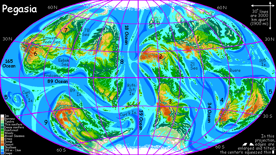
    TOUR PEGASIA! Survival tips first, then click on a region (just numbered for now): Continent 1 - 165 Is. - Continent 2 - Continent 3 - Rift-Junction and Curl 9 Is. - 1-4 Is. - Continent 4 - Continent 5 - Curl 5 Is. - Continent 6 - Continent 7 - Continent 8 - 89 Is. - Continent 9

    The gazetteer will have a full index of native placenames, with descriptions--once the contests's over and we have natives to name them.


    LISTS AND LINKS: Planetocopia - dreams of other worlds - ecology - climate change - evolution - populations and eco-crashes - natural disasters - terraforming - orbital dreams - sculptures and 3D art -

    World Dream Bank homepage - Art gallery - New stuff - Introductory sampler, best dreams, best art - On dreamwork - Books
    Indexes: Subject - Author - Date - Names - Places - Art media/styles
    Titles: A - B - C - D - E - F - G - H - IJ - KL - M - NO - PQ - R - Sa-Sk - Sl-Sz - T - UV - WXYZ
    Email: wdreamb@yahoo.com - Catalog of art, books, CDs - Behind the Curtain: FAQs, bio, site map - Kindred sites