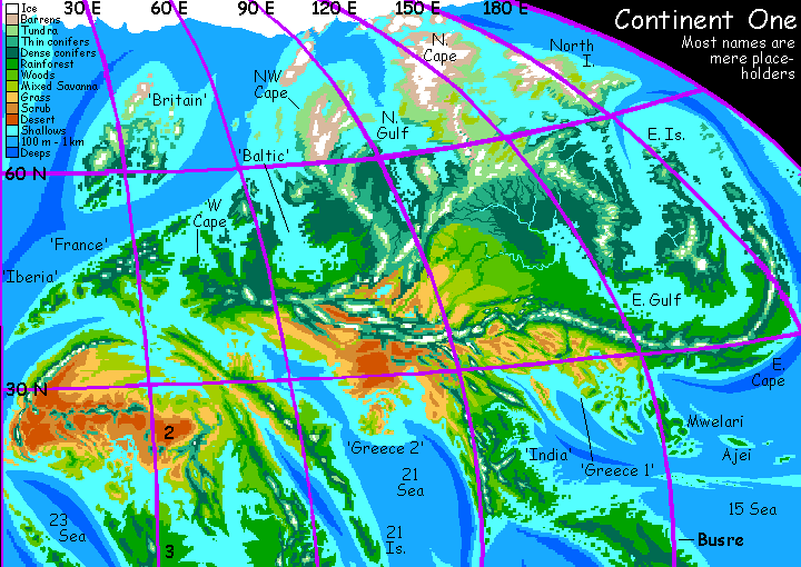
CONTINENT 1
by Chris Wayan, 2006-2010
Pegasia's homepage - Map - Geography & climate - Evolution - Critters - Gazetteer - Sketches - More worlds? Planetocopia!
First-time orientation--strongly advised! Pegasia is weird.
Overview - the Western Isles - a Slight Detour - the North Woods - the Eastern Sounds - the Sunny South
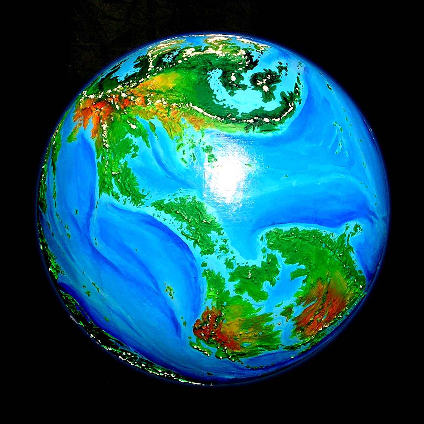
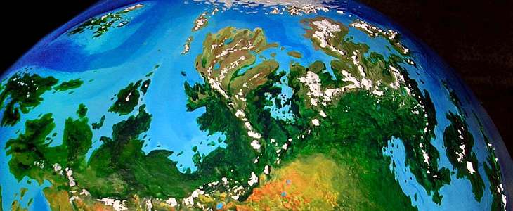
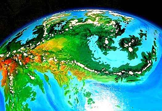
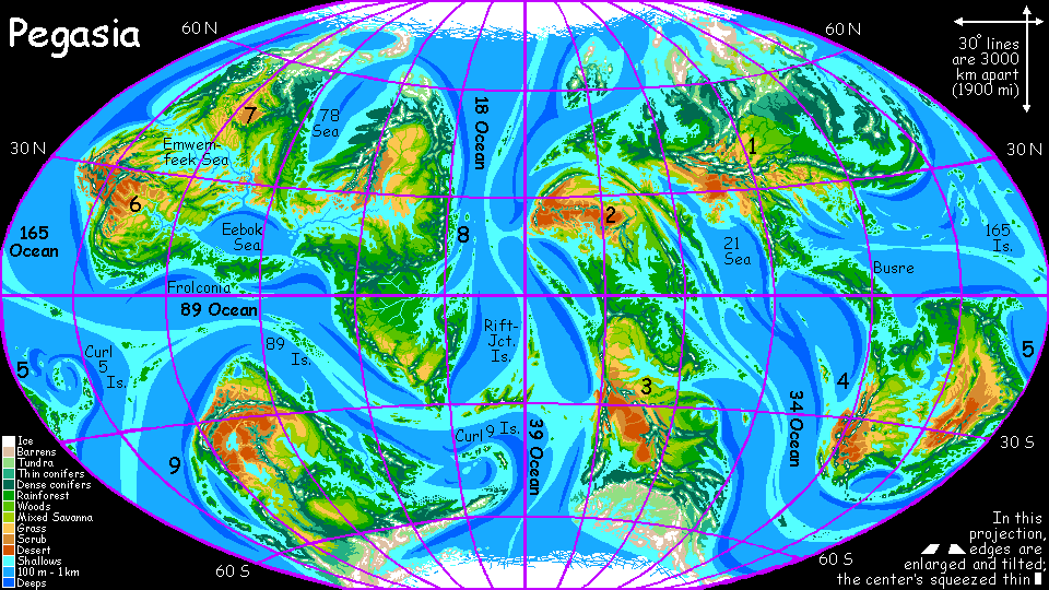
Continent 1 is the largest landmass in the Outer Hemisphere and probably the biggest on Pegasia. In the high-orbital photo below, it's the continent at the top. Continent 4 and Continent 5 are below and to the right; on the far left, the coast of Continent 2 is just visible, and to the lower left, Continent 3. None of the straits between these five landmasses are difficult for either flying species or primitive mariners; the five form what we may think of as the Pegasia's Old World, the better-connected hemisphere. Jared Diamond argues that it isn't fertility that makes a land progress but position--crossroads collect ideas and innovations, even if they're swept by plagues or wars. Continent 1 is the Outer Hemisphere's crossroads. Expect advanced cultures. Or invent them!
A second very visible difference is it's maritime. Only Asia's fringes are broken up, but Continent 1 is positively spidery--arms of the sea reach deep into all but the very heart. This has twin consequences:
Overview - the Western Isles - a Slight Detour - the North Woods - the Eastern Sounds - the Sunny South
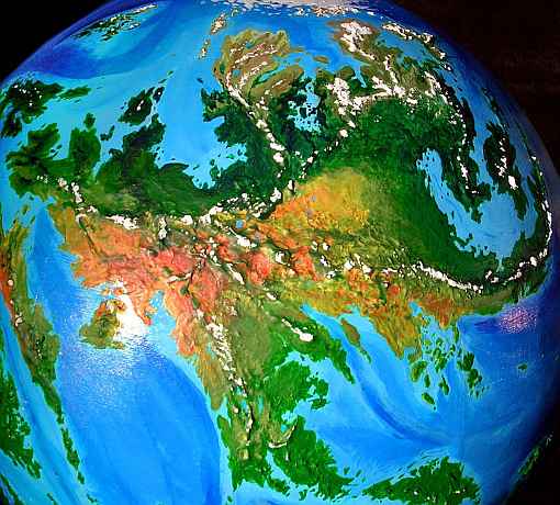
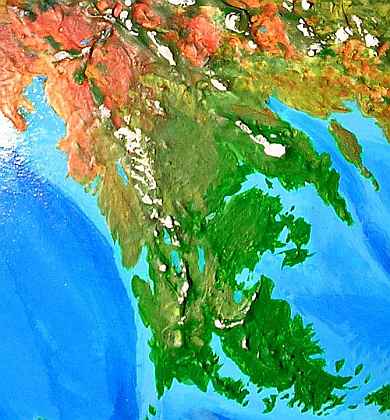
This next photo, a low orbital shot, shows northwestern Continent 1: a rather European peninsula and islands.
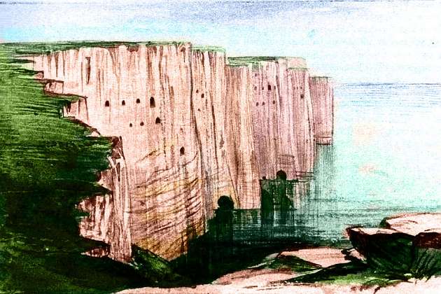
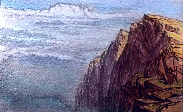
In the extreme northwest is a sort of Britain--with the emphasis on "sort of". It's much further offshore than ours, a mini-plate truly splintered off from the continent. It's also more broken and scattered--remember, Pegasia's current sea level is rather high. The main island is cool-temperate like England, but satellite islands range from subtropical to Nordic. The archipelago looks colder than it is; offshore is a trench, and in response to the oceanic plate's subduction, both volcanic and fault-block ranges hulk above the coasts. These are ice-mantled, giving the cluster the look of an overgrown Iceland or Spitsbergen. But the coasts and lowlands are quite mild, and densely forested in places.
All that's certain is that they're fliers taking advantage of the sea-winds slamming into these cliffs. A perpetual updraft! No trudging to the fields, at least. But there's a psychological boost as well: these won't be isolated peasants! Not where every cliff and mountain ridge is a freeway. News will travel the length of this archipelago, this Britain, in a single day.
But these isles are culturally and geologically apart from the rest of Continent 1. Let's tour the continent proper...
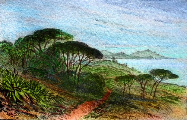
The western tip of the continental platform is an island as big as Ireland, followed by one the size of France, then a peninsula the size of Iberia. But all greener. Professor Higgins was wrong: the "rain in Spain" does NOT "fall mainly on the plain!"--coastal mountains block most storms from reaching Spain's central plateau. Here on Pegasia, though, Higgins is right: all of Pseudo-Iberia is exposed to sea winds; the broad coastal plains and inland mountains are mantled in rich subtropical broadleaf forests. Not a bit like Spain! Well, except for the hexagonal Alhambras dotting the rivers--they're almost Spanish with their red tile roofs.
So western Continent 1 lacks a landlocked plateau like Spain's. But there's a second reason the region has a greener south shore--it doesn't border a landlocked Mediterranean with deserts beyond; instead there's a broad strait more like Earth's ancient Tethys Sea. Storms have a longer "fetch", some rolling in from thousands of km to the east. Louisiana, not Italy...
Well, I exaggerate. This keep or village or whatever it is on the southern shore of Pseudo-France could almost be on the Riviera or in northern Italy.
From pseudo-France, let's flap east over the channel to the mainland. Green country, but not Germanic; coastal Oregon perhaps! Rainy, tall forests, rare snow; almost subtropical, even at 50 north. Inland rise rocky hills, cupping fingerlakes; even more like northern Italy.
The next day northeast, riding the winds along the irregular spine of the Western Peninsula, a second cape reaches north, a larger one. More European, with consistent winter snows--for all of three weeks! Remember Pegasia huddles closer to its little sun; the year is brief, so it's harder to freeze or starve unless winter's truly a big chunk of the year... It isn't global temperature alone that makes Pegasia's high latitudes milder than Earth's! For both animal and plant life, the metabolic bottleneck isn't precisely how hard it freezes, but how long food production halts...
The great, mountainous island northwest of this--pseudo-Copenhagen?--is Nordic but again with a short mild winter on the coasts; inland, though, the volcanic uplands really could host a winter Olympics; the highest peaks bear glaciers. Pegasian summers are shorter too.
Overview - the Western Isles - a Slight Detour - the North Woods - the Eastern Sounds - the Sunny South
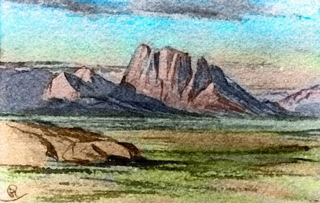
Let's veer to the right into the mountains for a long day's detour. The winds off the sea will help us over the first high ridge. Inland, it's much drier. The mountains do wring some further rain out of the thin dry air--and each ridge is higher, falling to desert basins, steppes, alpine meadows, but always rising again, relentlessly. Not quite Tibet or the Tien Shan, but rugged, with sparse trees and stony little streams gouging out surprisingly deep canyons.
Big on scenery, but short on fertility. No surprise there--it's true on many Earth continents too. But unlike Asia's hinterland, these steppes, mountains and plateaus aren't endless; the interior is at most a tenth of Continent 1! It's true that this "Central Asia" is dangerously close to "Western Europe's" rich lands, much as Beijing was always vulnerable to barbarian hordes; but even if Pegasians had the concept of war, here the hinterland's too small to raise more than a barbarian gaggle. Not to mention that these folk probably make an excellent living in trade and tourism; the central mountains form another of those great Pegasian flyways, an aerial Silk Road. Who needs banditry?
Oh well. I only wanted to remind you that although circumnavigating a continent generally reveals its most fertile lands (life loves borderzones!) Pegasian continental interiors needn't be as culturally isolated as they often are on Earth. Wings alter all! Continental spines aren't barriers but cosmopolitan flyways. These folks may be sophisticated indeed. Whoever they are...
Let's head north, back over the mountains toward the northern sea. It's the lands off those flyways that are lonely and backward; lands like...
Overview - the Western Isles - a Slight Detour - the North Woods - the Eastern Sounds - the Sunny South
This vast region is not Siberia. Pegasia's Arctic is milder than ours: it isn't landlocked, so it's not cut off from southerly currents; and no large landmasses are polar enough to ice over like Greenland, so this Arctic Sea thaws by midsummer, and northern winters are relatively short and mild.
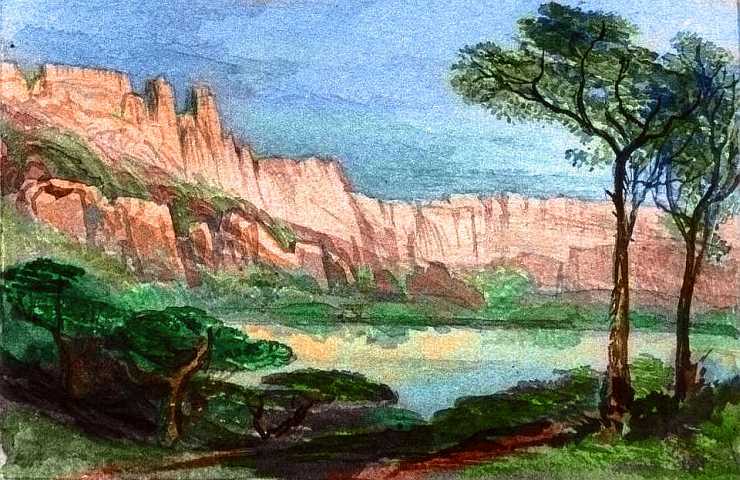
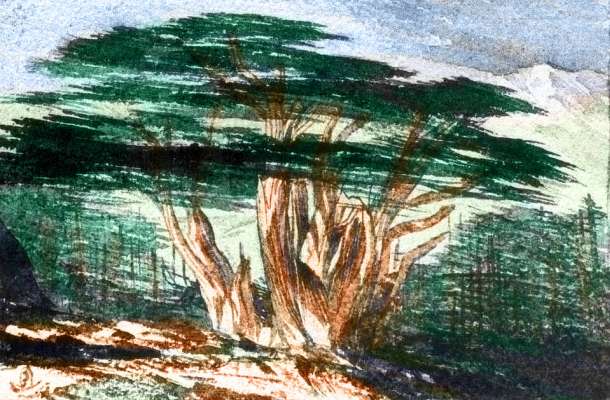
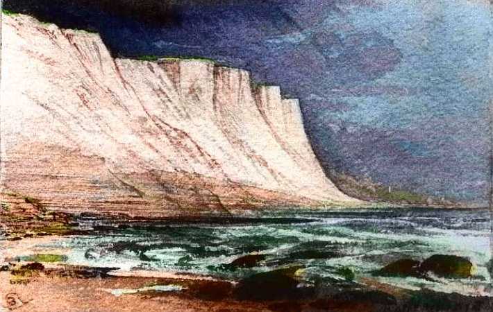
Still, this is another world after the mild "Baltic Sea" region. As we flap north over the endless wooded hills at the base of the Northwest Peninsula, ice gleams ahead. I don't yet know the name of this range, but I do know the peaks reach 3-5 km high (2-3 mi) and the passes 1-2 km (3300-6600'). Conifers or the local equivalent--cold-tolerant trees, dark to absorb heat and loaded with resins for antifreeze--pass like a belt of shadow beneath us, then thin as we rise to a pass. To either side, alpine meadows below red rugged castles, stairs and walls, crowned and veined with ice. From the crenellations, the range appears to be sedimentary, like the Rockies--unlike most of the coastal mountains we've seen, which are mostly volcanic or tilted fault-blocks of granite. But we're now far from the plate-edge; as far as you can be on busy little Pegasia, with all its rifts and trenches. We're only a day's glide from the sea, but geologically we're continental!
After the stark mountains, the lowlands ahead are a surprising: a great trilobed gulf with very different lands around each lobe. This is Continent 1's real Scandinavia!
The northeast bay is cool, with thin forests and open meadows, for it's past 60 north and has rugged mountains inland; still, the coastal valleys are far milder than our Siberia at that latitude. They look like it though, since Pegasia, with no recent Ice Ages, has less life specialized for long snowy winters than we do. Pseudo-Norway!
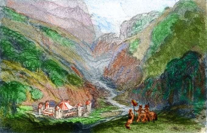
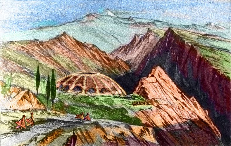
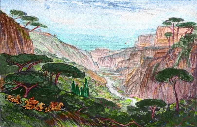
The central lobe, which we're gliding toward, is by far the richest: a coastal plain 2-300 km wide reaching down as far as 43 north, with rich boreal forests where broadleaf trees again join the mix. Pseudo... southern Sweden's farm country? But milder still. The Rhine? Yes, Centralobians will have great vineyards. Even Earth birds get bombed on fermented berries and swoop on cats, laughing themselves silly. These people will grow grapoids, and get sloshed, and fly into trees now and then. Ow. You know they will. But what else will they do and be? You tell me.
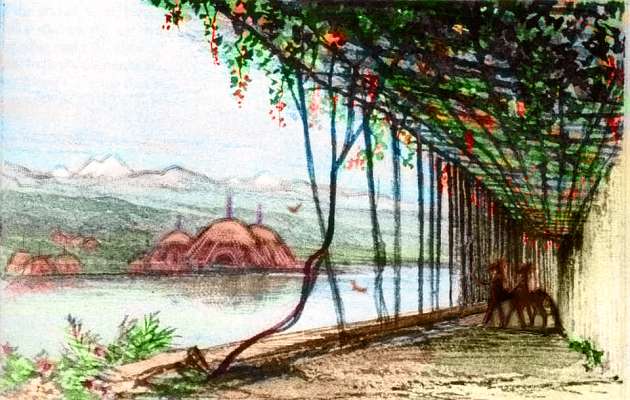
Mind you, don't take the sketch too seriously. Trellises, yes, but those centauroids could well be tourists like you. Who knows who lives in those thatched, spired domes across the water? Only you do. So tell us!
A day of hard flying over rugged hills and we descend to the eastern lobe of the great sound. Narrower plains than the central (centaural?) bay. And higher mountains, and further north--I'm afraid all that means we're back in Scandinavia again...
Overview - the Western Isles - a Slight Detour - the North Woods - the Eastern Sounds - the Sunny South
East Asia it's not. Four broad differences:
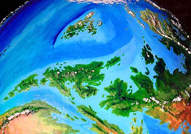
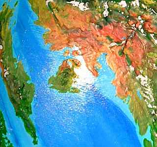
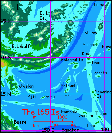 A flotilla of islands great and small, plus the relative starkness of the land, suggest that whatever culture develops here (you tell me) will rely on the sea--both fishing and trade. Expect its sailors to fan out early, along the coasts of Continent 1. And further out, I think; the lush 165 Archipelago sprawling thousands of km to the east has several island-names that are cognates of Mwelari, the largest island (caught in the sun's glare in the orbital photo above) just off this Grecian peninsula.
I suspect that just as prehistoric Taiwanese fishers may have spread over the Pacific to become the Polynesians, the Mwelarians spread (more likely by wing than by sail, but you tell me) so far from Continent 1 that their descendants, from chilly Tolea to sweltering Labira (and beyond) remember their homeland only as a myth.
Introduction - the Western Isles - a Slight Detour - the North Woods - the Eastern Sounds - the Sunny South
The larger peninsula on the long south shore is quite different. It's bigger than India, and reaches closer to the equator. Southeast Asia blocks our India from getting Pacific storms; but this Pseudo-India, open to the east and reaching deep into the tropics, gets monsoon rains in the north and heavy year-round rain in the south. Luxuriant forest everywhere!
Inland, there's no equivalent to our dry Deccan Plateau; instead, hills rise gradually to a tall, snowy range near the west coast, trapping more rain. The southwestern shore is as lush as Kerala, but the rainy strip extends further up the coast.
The whole great peninsula will support a great civilization--of some kind. But what? You tell me. All I'm sure of is that it won't be the Nevros, the strange natives of the Far East; their unique body structure (or lack of it: a Nevros is essentially a horde of coordinated gnats) leaves them vulnerable to a wasting disease endemic to these jungles: too many gnat-catching frogs. Travel is supposed to broaden the mind, not eat it! The Nevros call this the Amnesia Shore.
Here at the southern tip of Continent 1, fliers must make a choice--to complete their circumnavigation of its coastal lands, or to peel off and head southeast into the tropics, to huge Busre Island (which, before it suddenly became the ancient homeland of the arboreal, winged, antlike Busrehi last year, I was calling Pseudo-Sumatra for obvious reasons) and the Twin Continents beyond.
However, let's assume below that you decide to complete the circuit of Continent 1 and then hop to Continent 2 over the western straits... though I'm kind of tempted myself to peel off. You see, if we head back north the next few weeks get rough.
Why? Our Pseudo-India does have one drought-prone strip: its northwest coast grows increasingly dry as we fly north. Here, the trade winds come from inland most of the year--from huge mountains, wrung relatively dry of rain. The hills grow scruffy. Olive and rust, then gold, then brown...
Past 20 degrees north, true desert appears. This dry rugged lobe of Continent 1 has the size and general look of Iran-plus-Afghanistan. But without Pakistan; there is no equivalent of an Indus Valley. Instead, tall, snowy but scattered mountains send down small snowmelt streams, creating many narrow, irrigable strips and shallow canyons in the dusty red plains below their forested shoulders.
These mountains are broken up, not a single great coastal wall like Iran's Zagros Mountains. Thus, even weak monsoon storms can blow well inland, dropping rain and even snow onto any mountains high enough to block their passage.
So the inland deserts here are much smaller than Central Asia's, with milder winters; while the highest peaks are Andean to Himalayan, Pegasia's low gravity and dense atmosphere create higher air pressure and milder climate at high altitudes.
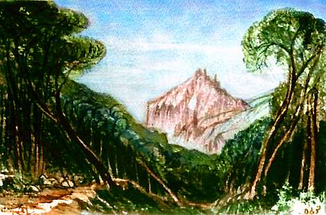
It might not be such a bad life here, if you're winged and can cross the desert from one of these green sky-islands to the next in an hour instead of dusty days. A migrant cycle: summers in the mountains, winters down in those warm canyons.
Don't take my sketch too seriously, but I do see broad-winged creatures designed to catch those desert thermals... but what do they look like, what do they eat, how do they see the world? Sing along with me, now: you tell me.
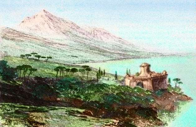
Offshore is a second Mediterranean archipelago, dominated by an island the size of Greece. Rocky, semiarid, with mostly scrubland in the north but more groves and tree-lined streams in the south, away from the desert, where the sea winds bring modest seasonal rains. A giant Crete? An island Yemen?
This unpromising land has an attraction humans would miss. For fliers out of the Twin Continents and southern Continent 1, it's the shortest (and greenest) flyway, to Continent 2 and Continent 3. So although the sparse biomass can't support a huge population and water will always limit the size of communities, I suspect it'll develop civilization rather early--just based on air travel, not shipping.
Further northwest, the coast grows merely semi-arid. A thousand dreary kilometers and you'll reach the fringes of the pseudo-Europe we started in. While not a lush coast, it's not a really forbidding journey for fliers or sailors; even caravans would find short creeks from the scrubby hills, at least during the wet season. Still, I bet most bulk goods travel by boat, though only when the monsoon winds favor it. A yearly cycle like the Arabian Gulf.
Still, let's do it. On the wing it's only a sweaty, thirsty couple of days. In the hot afternoons, we can swim in that mild and crystalline sea. Slowly the hills grow greener, the streams more reliable, the trees more extensive...
All right; you dutifully completed the circuit,Can we get to the fun stuff again? Like the crazy rift valleys of... Continent 2.
You did your homework,
You ate your dietary fiber...
The gazetteer will have a full index of native placenames, with descriptions--once the contests's over and we have natives to name them.
World Dream Bank homepage - Art gallery - New stuff - Introductory sampler, best dreams, best art - On dreamwork - Books
Indexes: Subject - Author - Date - Names - Places - Art media/styles
Titles: A - B - C - D - E - F - G - H - IJ - KL - M - NO - PQ - R - Sa-Sk - Sl-Sz - T - UV - WXYZ
Email: wdreamb@yahoo.com - Catalog of art, books, CDs - Behind the Curtain: FAQs, bio, site map - Kindred sites