World Dream Bank
home -
add a dream -
newest -
art gallery -
sampler -
dreams by
title,
subject,
author,
date,
places,
names
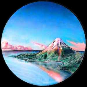
THE ABURROS SEA
by Chris Wayan, 2004
Serrana - map and regional tours - Creatures and People - Culture - Evolution - Gazetteer - How I Built Serrana -
More worlds? Planetocopia!
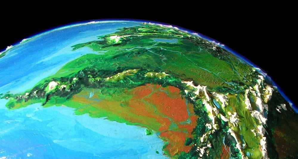
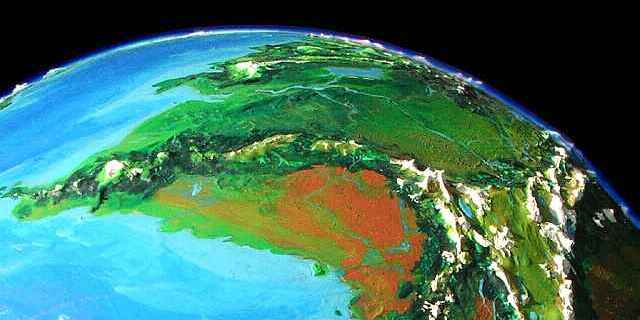
The Aburros is Serrana's Atlantic, with a similar wasp-waist. The North Aburros reaches to the pole; the South Aburros is warm, shallow, and dotted with islands. But unlike the South Atlantic, it barely crosses the equator! The whole Aburros Sea is only 8-9 million square miles (23M sq km), a third the area of the Atlantic--and only a fifteenth as much water.
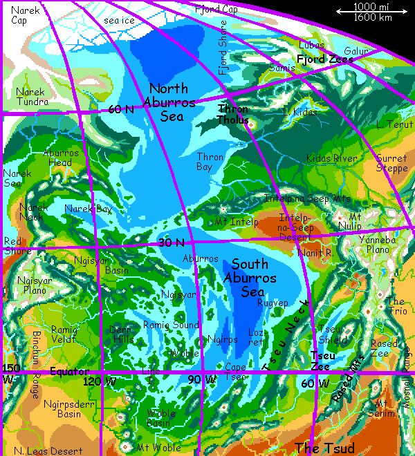
At the North Pole, a heavily glaciated range a mile high links the two small polar caps: Narek Cap to the west, a bit smaller than Greenland, and Fjord Cap to the east, about half as big. A broad ice shelf lines this north shore. In summer, low tabular bergs break off, shrinking the shelf to as little as 600 km; in winter it's at least 1000.
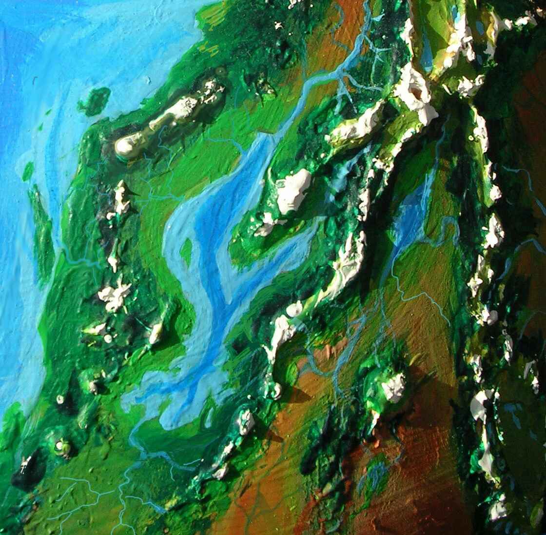
 The northeast shore is a series of deep straight "fjords"--not true ice-gouged fjords, just parallel fault-block valleys and ranges later sculpted by ice. The northern fjords are barren, the central ones tundra and bog, the southern densely forested. Inland are three brackish small seas, tundra-shored--the Fjord Zees. This is the edge of the mammoth heartland--nomadic tribes wandering east from the Zees halfway round the world, harvesting grass and lichens, guided by their shamans' dreams.
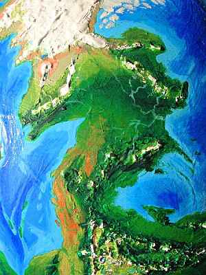
Beyond the Fjord Shore is Thron Forest, a conifer strip stretching 3000 km inland. The only breaks in the dark canopy are Lake Kidas, over 500 km long, with boggy shores loud with the cries of millions of nesting gryphons and birds, and Thron Tholus, a massively glaciated volcano 7 km high near the Sa Rethen Delta, creating an island of tundra in the somber pine sea.

The people in this region are nearly all featherballs, the shaggy cold-adapted subspecies of raptor--and they've only been here a thousand years. If raptors were human and this were Earth, they'd have "cleared" (isn't that a fine euphemism for "killed"?) the forest and planted farms, for Thron still is what prehistoric Europe once was. And as Thron warmed and dried and opened up, Planians and hexapi might well move in, if not winter-hating taurlopes.
But Serranian culture, due to its multispecies nature, adapts to the land rather than trying to change it. So Thron has villages under the trees full of featherballs and a few eccentrics of other species. Thron culture specializes in fine woodwork and exports lumber, pine nuts and dried mushrooms (some are tasty, others medicinal, and a few psychedelic)--the forest's their livelihood, not their enemy. It's not that Serranians are ecologically nobler than humans--it just doesn't occur to them to settle where they don't already feel comfortable.
 To the south, beyond the Kidas River, broadleaf trees and occasional meadows appear. The Thron Bay region resembles southern France. Villages are more common, populations more diverse, with hexapi and a few Planians and taurlopes as well as featherballs.
Inland, the climate grows slowly drier and the forest thins into riverine ribbons, until wide prairies stretch east--the Surret Steppe.
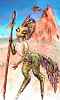
The North Aburros ends at the Intelp Peninsula, created by Intelp Tholus, a volcano 8 km high. Lesser cones just a few miles high stud the cape, curving inland and south--the Seep Mts. Between range and shore is the Intelp-na-Seep Desert; as big as the Kalahari or Gobi, it's one of Serrana's few coastal deserts. Offshore is a high-pressure zone of dry air, and the high mountain arc blocks storms from the north. Two snowfed rivers wind through the desert and arid veldt, making snaky oases: the Intelp in the west and the long, many-branched, lazy Nanit River in the east. Here live the other race of raptors: elegant, scaly, slender, fiery-tempered. Most are nomadic herders and hunters; only along the rivers can the land support permanent villages--mixed raptors and taurlopes.
Inland, the Seep Range merges with the Yanneba Plano and the Green and Sa Rethen Mts. The Sa Rethens are Serrana's Himalaya: guarding a rugged plateau much like Tibet, they're the highest range on the planet (except for a couple of Martian-sized volcanoes in the southern desert).
On Anarres, in Ursula Le Guin's The Dispossessed, the Abbenay region was this world's Eden--the greenest patch seen through telescopes, and the first landing site. Unfortunately the settlers found it cold and windy, though the rest of the planet was even worse. Now, my calculations suggest this plain would be hotter and drier than Le Guin believed--Mediterranean, even African. It worried me as I roughed in Serrana, for I wanted it to be a tribute to Anarres, and this region was utterly unlike it. But while comparing Earth and Venus to Anarres/Serrana, I've concluded that it's too poor in highlands; at least 10% should be the granitic plateaus I'm dubbing planos. So instead of a mere mountain range to the north and west, the upper Yanneba now climbs to a wide triangular plateau ringed by icy peaks--the Yanneba Plano, 4 km high! Cold windy grasslands sweep to the mountains. Thin air, fierce light. Sound familiar, Dispossessed fans? It's nearly identical in climate to Le Guin's original Anarres! The old, cold, windy, dusty, near-Martian Anarres is back. It's just up at twelve thousand feet!
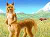
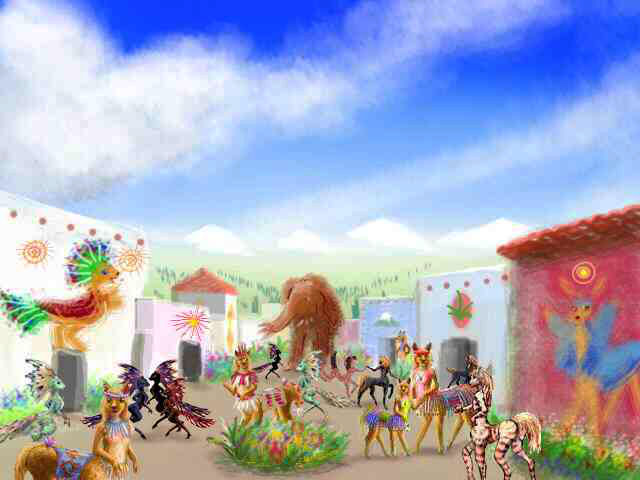
Most of the year, the only inhabitants are the planians, cameloid centaurs resembling Andean vicuñas with hands. But the plateau is on the border of many species' ranges; the Yanneba Midsummer Fair is one of the few places where sun-loving taurlopes and hexapi (even a few tree-squid) may meet featherballs and mammoths and exchange news, songs, ideas, books, art motifs and goods. While Yanneba can't be called a planetary capital like Le Guin's Abbenay, this windy plateau is, for one magic month, its cultural and trade center.
South of Yanneba Plano is a warmer world. East of the South Aburros Sea is a small sea much like our Caspian: the Zee of Tseu. The mountains between the two, on Tseu Neck, are as high as the Caucasus, so Tseu can't drain into the Aburros. The mountains block storms, too, so Tseu is 50 meters lower than Aburros. But it's no Dead Sea; while briny, Tseu is full of life, and big enough to generate its own rain. The surrounding ranges are pine-clad, while the shores are mixed savanna. It's true that over the snowy inner range, the Rased Mts ("raw said"), and in its rainshadow, is the much smaller, saltier, slightly alkaline Rased Zee, snowfed like Tseu but cupped in a desert with only salt marshes lining the shore.
Tseu, by the way, is pronounced rather like an upper-class Englishwoman saying "It's so." It could almost be spelled Tseo, and usually is in the south, around Cape Tseo, a chain of volcanic tholi rising 6 km above the sea.
Populations here are quite mixed, and culturally sophisticated; as elsewhere on Serrana where many species can live together, the diversity of thinking-modes leads to social and technological innovation. Many locals live not only in mixed villages but in mixed-species clanhouses.
But fertile Tseu is just a narrow coastal strip. Inland is the Tsud, (t'sood) a near-Martian desert spanning half the southern hemisphere, some 45 million square km (18 million sq mi, as big as all Eurasia)--an eighth of Serrana's entire surface, a quarter of its land. At its fringes, the Tsud fades into dry Sahelian veldt. In its heart is only red dust. The sky itself turns bloody--pink on a still day, salmon in the wind, brick red in a dust storm--or black.
The Tsud has its good side: Serrana's small, shallow, cut-off seas are surprisingly fertile because the Tsud dumps much more nutrient-laden dust into them than Earth's deserts drop into our seas.
At the shallow south end of the Aburros Sea, a chain of huge volcanoes marches into the sea, forming islands: the Woble Range ("wob-lei", not "noble").
The biggest, Woble Tholus, is over 12 km high (40,000 ft, twice Kilimanjaro), but half a dozen others reach 6-8 km. The southern peaks in the Tsud Desert are ecological islands of forest and meadow. Snowmelt from the peaks dead-ends in a series of saltmarshes and pans in the desert: these oases are the Woble Sinks.
West of the Wobles is the Ngirpsderr River, as big as the Niger. Its wide flood plain is green along the coast but quickly drying to veldt inland--partly a rainshadow effect of the great peaks, partly latitude, and partly just the proximity of the Tsud Desert, which the basin fades into. It sounds rather like "neerps dare" (the initial "ng" is like "singer" not "finger").
North of the equatorial Ngirps Hills, rainy and lush, is the Ramig Basin. The coast is an equatorial rainforest, greener than the Ngirpsderr: the first thousand km up the Ramig River are quite lush (tree-squid country), and the second thousand still green. The upper river is a lightly wooded strip branching across 1000 km of dry golden veldt, ending at last in the snowy Binchun Range (bean-CHOON), some 4500 m (15,000 ft) high.
This vast equatorial plain has a near-perfect twin on the far side of the world--the Mosnoll Basin.. Like Mosnoll, it's a taurlope heartland, though plenty of hexapi and short-feathered raptors live here too.
The Binchuns lack the usual desert on their inland side--the small Niirg Sea beyond prevents a rainshadow. Instead there's Binchun Basin, resembling California's Central Valley--a hot savanna veined with snowfed streams pooling to form wide marshes.
To the north, the Binchun Range widens into a great wedge of grassy, cool altiplano, Ngisyar Plano, some 3-4 km high and 1000 wide, ending in a second chain of volcanoes above the Red Coast of the Narek Sea. This rather Tibetan triangle was settled a mere 1500 years ago by llamalike Planians from the south. Ngisyar's initial sound is soft--it's almost n'ss-YARR.

Offshore, in Ramig Sound, hundreds of green islands dot the sea. Some are young volcanic cones as clean as Fuji; some are only the eroded spines and cores of long-dead tholi; all are fringed in coral reefs. Serrana's Indonesia! Tree-squid are the majority here, but a few taurlope villages dot the coasts, and the cooler mountain slopes are home to many Planians and raptors as well.

Beyond the Ngisyar Mts, an east-reaching arm of the plano about 3 km high, is the Ngisyar Valley, a long, narrow, lush subtropical basin. Not the most spectacular spot on Serrana, but surely one of the pleasantest. Populations here are among the most mixed on Serrana; all but mammoths are common. Along with gentle climate, Ngisyar Valley has a reputation as culturally progressive; the locals claim it's a direct result of the multispeciality of its towns. As their proverb puts it:
See it five ways,
solve it five ways!
|
North of the Ngisyar region, the land narrows between the Narek and Aburros Seas. This Aburros coast of this Narek Neck is temperate, rugged, and heavily wooded. The Narek coast is much drier, nearly Californian; the southern part is a true coastal desert, the Red Shore.
Aburros Head, north of Narek Neck, is the most isolated land on Serrana, with the highest percentage of endemic species. It's almost a true continent, at least biologically speaking--the only real migration corridor is up the Neck, for to the north is the polar ice. Serrana's Australia? Or Patagonia! The Head's geography is simple, nearly a million square miles of unbroken forest: hardwoods on the great plain and dark conifers in the northern mountains, thinning on the north slope into bog and tundra, reaching to the great ice.
Most inhabitants of Aburros Head are featherballs and, very recently, mammoths. They sailed in from Thron, across the Aburros Sea, taking passage on raptor-built ships. They had to: all the overland routes from existing mammoth colonies to the Neck skirt the tropics--fatally hot for mammoths. But even second-hand tales of Narek Tundra were too tempting. Too big for any hold or cabin, the Six Pioneers suffered through days on deck (as did the raptor crews: a mammoth can't duck enough to let the boom swing by, and it turns out they're prone to seasickness. One little accident can mean a truly odoriferous day of deck-swabbing).
But they're well-established now: over one hundred and calving successfully. A hundred may sound small, but when they meet at the Midwinter Fair, small is NOT the word you'll use, believe me. It takes a lot of land to sustain a hundred mammoths.
North of the tundra is Narek Cap again--ice a mile high, to the pole. You've circumnavigated the second largest sea in the world--though that's not saying much. Aburros contains less water than our Arctic Sea!
Don't be fooled by surfaces. These maps and orbital photos show so much water and life because water spreads out and life adapts. But assessed soberly, quantitatively... Serrana is dry.
And that's hopeful. Think of all the Martian worlds out there! It takes so little water and warmth. Life will do the rest.
 TOUR SERRANA! Click a region for a detailed ground-level tour:
Aburros Sea -
Woble Range -
Yanneba Basin and Plano -
Mosnoll and Eronit Basins -
The Tsud Desert -
Eamet Ocean and South Pole -
Leas, Niirg, and Narek: The Lesser Seas -
The Rakach Plateau and the Northlands
TOUR SERRANA! Click a region for a detailed ground-level tour:
Aburros Sea -
Woble Range -
Yanneba Basin and Plano -
Mosnoll and Eronit Basins -
The Tsud Desert -
Eamet Ocean and South Pole -
Leas, Niirg, and Narek: The Lesser Seas -
The Rakach Plateau and the Northlands
Serrana's homepage - Peoples of Serrana - Culture - Evolution - Gazetteer -
LISTS AND LINKS: more world-models: Planetocopia - dreams of other worlds - ecology - climate change - evolution - populations and eco-crashes - natural disasters - terraforming - orbital dreams - sculptures and 3D art - anarchy - utopias -
World Dream Bank homepage - Art gallery - New stuff - Introductory sampler, best dreams, best art - On dreamwork - Books
Indexes: Subject - Author - Date - Names - Places - Art media/styles
Titles: A - B - C - D - E - F - G - H - IJ - KL - M - NO - PQ - R - Sa-Sk - Sl-Sz - T - UV - WXYZ
Email: wdreamb@yahoo.com - Catalog of art, books, CDs - Behind the Curtain: FAQs, bio, site map - Kindred sites