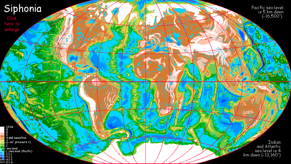
Siphonia:
AFRICAN OCEAN
by Chris Wayan, 2006-9
Siphonia - map - regional tours - People, Creatures - Evolution - (don't click yet: Gazetteer - Glossary) - more worlds? Planetocopia!
Overview
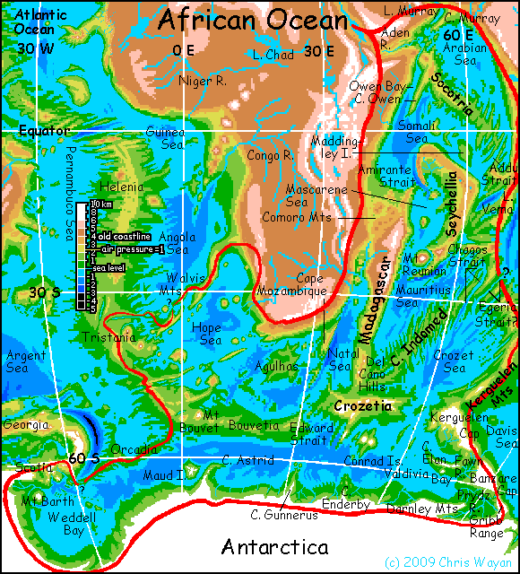
The African Ocean is one of the largest surviving seas in the world, comprising the southeastern Atlantic and western Indian oceans. What's more, one or two straits--a gap in the Walvis Range bordering the Hope Sea (lower left of map), and Orcadia Strait on the Weddell Sea (far lower left)--may link the African Ocean to what's left of the central and north Atlantic. If either of these low sills are under water--or have provoked a Canal Company to do the obvious and profitable, at any point in the 90,000 years since the Big Slurp... then the resulting Atlafric Ocean would definitely be the world's largest--by far.
A third possible strait, Egeria (middle right on map) may link it to the Bengal Sea. Even if that strait is a canal or river-portage or railway instead of a true salt-water passage, economically and culturally the Bengal Basin too will be part of the complex. The Atlafroben Deep? There's a mouthful...
Let's start our tour in the far north and work south.
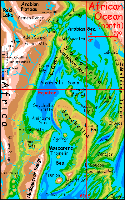
Arabian Sea
Aden Valley, at the mouth of the old Red Sea, is still hot, but wetter than the old Aden coast. The snowy Yemen and Guban Ranges to the north and south are up to 5 km tall (16,500'), sending snowmelt streams down into the great valley. The Aden River cuts a tortuous path around low, jagged ranges and mesas, thinly wooded on the heights and along riverbottoms, but raw rock between. Downriver, though, the river slows and winds into Lake Aden; these hills are green with monsoon forest, for we're nearing the sea.
And a very different sea it is. The shrunken Arabian Sea actually evaporates more water and generates more rain today than before the Big Slurp, for the dense air of the African Deep traps heat; the surface water is hot enough for hurricanes much of the year. These batter the lower Aden Valley, Lake Kuria to the north, and Cape Murray beyond. Lake Murray, behind the ridges of the Cape (up to 3km/2mi high) is somewhat sheltered from these storms, though not as much as the upper Aden Valley.
The storms don't help the surrounding highlands much at all. The mountain-rims are just too high; they wring most of the moisture out. The Arabian Plateau is a cool, semiarid plain, 4 km above the sea. But nowhere near as dry as on Earth! The snows of the Oman Mountains feed Lake Samim at the plateau's east end; in our world Samim's a dry saltpan.
Further northeast, the Hormuz Valley, draining the Persian Basin as well as much of the Arabian Plateau, is cooler than Aden but equally rugged and dry, a super-Grand Canyon--it too is cut off from sea winds by the icy Oman Range, rising 7000 m (23,000').
Socotria
Part of the Mid-Indian Ridge, this long fertile peninsula has hot muggy (Carboniferous!) shores watered by constant storms. Inland rise the Carlsberg Mountains. The highest peak is Mt Socotra, over 5500 m/18,000'--nearly as tall as Kilimanjaro, but snowless; it's just too hot here in the Deep. The highlands are sunnier, with mild tropical temperatures--like the highlands of our Sri Lanka or New Guinea, they're above the worst of the storms.
All of Socotria, high or low, is a rugged washboard of intersecting ridges, looking like a gigantic fish skeleton. As a result the coastline's endless--long deep sounds and cliffwalled capes.
At the southeast end of Socotria, one such narrow sound cuts right through to the Somali Sea--the Addu Strait.
Somali Sea
We enter the Somali Sea at the southeast end from the Addu Strait. There's a large bay to the south, Lubine Bay. Beyond is a rugged series of gashes, very hot country, covered with open forest: the torrid Vema Valleys. The deepest, sinking far below sea level, is an old trench, and is still flooded: mile-deep Lake Vema holds a significant percentage of all the fresh water in the world.
Sailing up the Somali Sea, we head northwest around Maddingley, a new island the size of Sri Lanka, and with an even warmer climate. It's just a big rolling carpet of rainforest. I'm into rugged scenery, this trip. Let's sail on!
Beyond are the Coco de Mer Islands, the last of which sports a volcano taller than Fuji, rising above the clouds into the sun. Quite impressive--if the clouds ever part to give you a view. We're straddling the equator here; there is no dry season.
The view to the left is even more impressive, even in snatches through the mist. The southern shore of the Somali Sea is a stunning row of cliffs and scarps leaping into the clouds, like Roraima, but far higher: Seychellia is mostly a limestone plateau 4 km up (13,000'). The upland basks in a mild perpetual spring, above the muggy rains of the coast. Woods and meadows around small lakes with no visible outlets--the lagoons of old atolls, draining through the limestone. Huge caves and sinkholes riddle the uplands. In places, the cliffs drop straight into the sea; in others, sluggish rivers wind through a lowland rainforest between the cliffs and the sea.
Seychellia's coastal scarps grow ever steeper and more spectacular to the west until we reach the mouth of Amirante Strait. We won't sail through just yet, but enjoy the view. The Seychelle scarps are near-vertical here, and still 4 km high (over 13,000'), but really still taller, for the drop continues a mile under the water--Amirante Strait is one of the deepest points in the African Ocean. But before we head south through the strait, let's loop around the western Somali Sea. Two days' sailing past Mt Coco, we reach Cape Owen, a straight ridge some 500 km (300 mi) long and 3 km high, looming above equally long, straight, deep Owen Bay. Owen's a fracture zone where the Mid-Indian Rift is making a small adjustment--blowing off a little stress. If you haven't noticed, the Rift makes a great curve here, nearly surrounding this sea and squeezing inward like a stone anaconda. The compression's savage; the crust cracks and buckles, and volcanoes relieve some--not all--of the pressure.
If we sailed up Owen Bay to its head, you'd find a typical fracture-surprise: the mouth of the Aden River! Though it was just a few miles from the sea at Lake Aden, the lake drains southwest, right through a mountain range over three miles high! It never cut this canyon, of course; just followed the Owen Fracture. Regardless of its cause, it's one of the deepest gorges in the world. But out of our way; we sail south.
The Somali coast is hotter and wetter than it was. You can always head 100 km inland and 4 km higher, if you're sick of the heat. Mogadishu, and Mombasa to the south, now have year-round spring, really--much like our Nairobi and Addis Ababa. Beyond, and a mile still higher, lies the chilly altiplano and icy peaks of the eastern African Upland. Here, I'll stick to old sea-basin and what it's become.
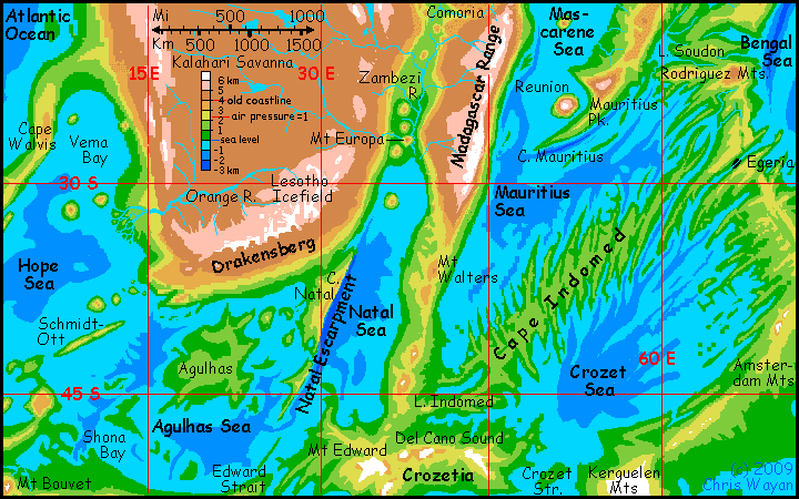
Comoria
The southwestern corner of the Somali basin is Comoria--wide hot plains of open monsoon forest and savanna, studded with volcanic ranges--Aldabras, Cosmoledos, Farquhars, and, furthest inland and tallest, the Comoros. Mt Moroni in the western Comoros rears over 6300 m (21,000') over the sea. The slopes of these giants are rings of rainforest, alpine meadow, and cold desert. Thunderstorms drop snow and hail on the summit, but they don't build up; the Snows of Moroni are intermittent. The dense air here traps too much heat for permanent glaciation.
Comoria's one of the driest equatorial regions in the Deeps--though that's not saying much. It's stormy much of the year, but when the Arabian Plateau heats up in summer, winds blow north, and there are several months of uninterrupted sun. But you only risk sunstroke, not sunburn: very little ultraviolet reaches this deep. Even on the clearest day, the sky's a pale turquoise, almost white; even at noon the sun's a mellow gold. The good side of such dense air!
Sailing east along the Comorian shore past Cape Wizard (I do not make these names up; Mt Wizard is another snowless tropical Fuji) we've come full circle round the Somali Sea: the cliffs of Seychellia rise from the sea, ahead. To the right's a gap: the mouth of the Amirante Strait. This time we'll take it, south into the...
Mascarene Sea
For me, Amirante Strait is the jewel of the northern African Deep. Misty cliffs double or triple Yosemite's height, laced with waterfalls bursting from the sides not the top--where sunken streams hit volcanic bedrock below the coral... just amazing.
Perhaps we should take a side hike up through the (stifling) jungle slopes to the mild, more open uplands of Seychellia. The sun is a relief after the muggy Deep. This strange plateau is a green desert, like our Yucatan; enough rain to sustain a forest, but the porous coral rock drains streams underground, creating cenotes and huge caves.
I'm tempted to stay up here, switch to a land journey now, for Seychellia's plateau is pretty flat. But it's a long, long curve around to our next strait and sea, Mauritius.
I know! Let's rent gliders and skim back down to the sea. The air's so dense it's easy even for novices to get enough lift. I haven't discussed life in the Deeps on this page, but the short version goes: dense air and rich oxygen make flight so easy that many of the locals fly or glide. Giant intelligent parrots probably make up a majority of the lowlanders here. Highlands like Seychellia, whose air is too thin, look more Earthlike. Yes, gliders and lowlands, definitely. I want to show you the more alien side of the Deep.
Let's sail south into the Mascarene Sea. It's only a day or two to the rugged Agalega Islands, and another day or two to Tromelin. These are steep volcanoes rising 4000-5500 m (13-18,000') from the sea. Tromelin's far enough from the equator to have strong seasons, so rather than the alpine deserts of old Kilimanjaro and modern Moroni, Tromelin has a wide ring of alpine meadows above its rainforested knees.

But the greatest of these island-peaks is last. Off the south end of Seychellia's long arc stands a lone island bigger than Bali called Réunion. Its summit, heavily glaciated, is 7 km high (23,000'). Like Tromelin, every climate from Arctic to tropical can be found within a few miles on its slopes--and as a result, every intelligent species on the planet has found a home here except megaravens (up where it's cool enough for them, the air's too thin for easy flight). The diversity in ways of thinking has led to greater innovation; Réunion, though small, is a center of world culture. On shore to the east, the same is true of the slopes of the Mauritius Range, 6 km (20,000') high, ringed with alpine meadows not barrens.
The east or Seychellian shore of the Mascarene Sea is low, a long strip of rainforest hundreds of km deep, slowly rising inland toward the arc of limestone plateaus mentioned before--Seychelle itself, Saya de Malha, Nazareth, and Carajos. But the lowlands here are one of the Deep's great population centers; not human, of course, who'd want to live down in the hot damp moldy gloom under hundred-meter trees? Megaparrots and lemurs build their villages in the treetops, where the sun (and food) is.

Madagascar
The west or Madagascar coast of the Mascarene Sea rises sharply to 6900 m high (nearly 23,000')--geology writ even larger than the Amirante Strait. The old island's spine is now snowy in winter and bears small glaciers. Definitely not lemur country any more!
But the lemurs are still here, just lower down the slopes--and larger. With lungs and brains supercharged by the dense, oxygen-rich air of the Deep, both lemurs and African apes have grown both physically and mentally--probably to human levels. They have broad new habitats in which to do it--Madagascar has tripled in size and is linked to new lands south and east. Siphonia has much more rainforest than Earth--indeed, you could almost circumbrachiate the planet--swing around it Tarzan style, without ever leaving the trees. Well, those pesky Americas are still in the way--too high and cold. But that wall's on the far side of the world; Madagascar's now the center of the jungle-basin complex. The lemurs (like the orangutans of Sumatra and Borneo) will spread the way humans did when we exploded out of Africa.
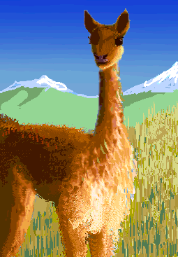
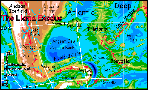
One people who didn't exactly explode out of their homeland are here in modest numbers: the llamas. As the Altiplano iced over, llamas and their woolly cameloid cousins--guanacos, alpacas, vicuñas--all fled downhill, along with the entire Bolivian nation. They settled the Amazon Upland, the coastal mountains of Brazil, and Patagonia Steppe.
Over the millennia, one group spread further south, into the cool hills of the Scotia Deep--warm and damp for a llama, but cooled by the (remaining) snows of Antarctica, they were tolerable. Llamas adapted. In the southeast, the receding sea left an isthmus, called Orcadia, leading to the lands along the rift zone on the floor of the South Atlantic--Bouvetia and Tristania to the north.
In those cool but oxygen- and food-rich highlands, llamas evolved--and spread. Their ancestral stock had already been bright, but the creatures that discovered the Walvis Mountains, a landbridge to the cool highlands of South Africa, were debatably people, if primitive. The new altiplano around the Lesotho Icefield became their homeland.
Twenty thousand years later, a small herd of their literate descendants crept north along the Malawi Mountains to explore East Africa's cold highlands, where they flourished.
But one bold group listened to gorilla tales of snowy mountains to the east, in the African Deep. Unlikely, but they chanced it--descending into Comoria--the old channel between Africa and Madagascar, now a hot savanna studded with tall volcanos. Like shaggy Polynesians hopping island to island, the llamas settled one volcano after another.
They took generations to reach the prize--Madagascar's highland. Cooler than today, and far larger; sweeter grazing than the altiplano ever was! Madagascar became their heartland; they fanned out to other ex-islands of the Indian Basin. Today, llamas are present (if not numerous) in the plateau-forests of Seychellia, and even on the slopes of Mt Mauritius. But only a couple of explorers and eccentrics have reached Réunion, though its mountain-meadows are llama paradise.
It's only been ninety thousand years, after all; give them time. Feet and time together. Partners in the evolution waltz.
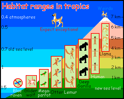
Giant lemurs, Amazonian otters, and great apes face challenges much like the llamas, though in their case it's cold and thin air (not clammy heat) they dislike. They may have required the bizarre conditions of the Deeps to evolve, but they can endure that thin upland air; pioneers spread. Whether you like it hot or cold, Siphonia's many landbridges do make it easier for a creature to end up worldwide--patchily distributed, perhaps, but ringing the globe. Fliers are the exception; newly exposed mountain ranges and of course the ex-continents can pose fatal barriers to megaparrots and blue ravens, now so huge they fly clumsily (if at all) out of the Deeps. And gliderwolves are grounded entirely except on the abyssal floor.
The result of all this spread? All over the warmer parts of Siphonia--mostly but not all lowlands--you'll find otter-run diving tours, bonobo-run conference centers and Club Meds with really, really loud lemur bands.
I just trivialized a real point, one we've seen on Réunion and Mauritius: this Madagascar coast is a third biological hotspot where habitats meet--not necessarily a biomass- but a diversity-hotspot. And on Siphonia, biological diversity breeds cultural diversity. Once intelligence crops up in more than one species, such meeting places become innovation centers.
The idea that geography fosters or suppresses ideas seems odd to us, but it's true even on monotonous Earth, where a single species of ape gets all the patents! But not evenly. Ports and borderzones innovate the most. As I write, one-fourth of all patentable U.S. inventions are registered in a single state, California--the most racially and culturally diverse. Social and political policies matter, but until the present century the soil of any renaissance required a little sea-salt: a harbor, world trade. Airlines and the Web are at last decentralizing civilization, but for millennia coastal cities had a near-monopoly on real innovation.
On Siphonia, these ecodiverse hotspots are strong rivals to port cities; and they occur around sharp differences in altitude in climates warm enough so life can take advantage of the full range of niches up those mountain slopes. Madagascar is ideal.
This Madagascar coast isn't a hotspot of innovation, either: it's a long strip, extending over a thousand miles (1600 km) beyond our island's end. This southern part of the range is lower and breaks up some, but peaks like Mt Walters still are Alpine in height. But the snowy wall is gone; inland is a rolling high plateau with mild winters, not so different from Old Madagascar's highlands, and ideal for lemurs (and humans, and llamas). When our Madagascar highlands iced over, this is where the biomass fled! It became the bridge by which the swiftly mutating lemurs spread into the Deeps to the east; they certainly didn't cross that ice wall to the north!
I'll discuss the western slope of Madagascar (still quite habitable, and indeed much expanded) in the Natal Sea section below. Eventually. This is a work in progress...
Chagosia and the Mauritius Sea
We sail on through Reunion Strait, south into our next sea: the Mauritius Sea. As mentioned, its west shore, the Madagascar shore, is lower than in the north, but still rugged straight and steep--a continuation, nothing new. Instead of sailing down it let's turn east at Cape Mauritius and sail up the length of the Sea.
Deep azure water under our keel, and no reef-spotting lookout, routine on much of our journey up to now. We're sailing along the Mauritius Trench, still a mile deep despite the Big Slurp. To the north, over the long low Cape, the glaciers of Reunion float in the hazy dense air two hundred km away, like a scoop of levitating ice cream. Antigravity--my favorite flavor!
We run northeast into the fjordlands of Chagosia. It's much like Vema Valley to the north; rugged, hot, humid, forested. Astoundingly vertical country! Cliffs feathered with white Angel Falls every mile, dropping from misty mesas into straight deep sounds.
Chagos Strait is merely one of dozens of these "fjords" along both shores of the Mauritius Sea... a few miles wide and hundreds long, it leads south into the Crozet Sea.
Cape Indomed and the Crozet Sea
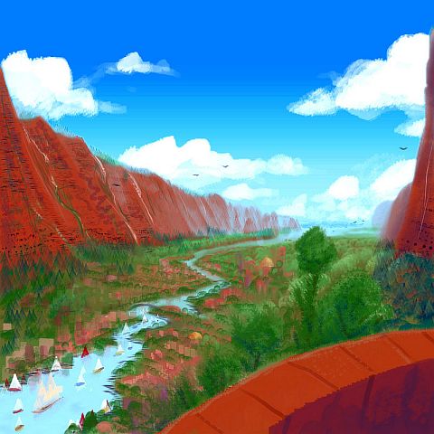
If we turned sharply left at the mouth of Chagos Strait and head northeast, back up the next fjord, it too may turn out to be a strait to another sea, the Bengal Sea south of India (off the map to the right). It isn't certain; the Egeria Valley certainly cuts through, but its altitude is right around the likely sea level; it may be a strait, a short portage, or a salt-water river from the swollen, trapped Bengal Sea, lying a bit higher than the African Ocean. I'm just not sure. But no matter what sort of shipping-bottleneck it is, Egeria will be a major port city. And a scenic one! The fjords here are relatively dry; over the town loom red cliffs streaked with waterfalls, white water, green ferns, black moss, like the flanks of a psychedelic zebra.
More recent bathymetric maps show that the fracture zones cutting deepest--the most likely places for this port/canal city--are really southeast of Egeria, around 30°S & 70°E--that's even past the next fracture zone, Flinders, halfway down to toward Ter Tholen and Zeewolf Fracture Zones. So call the town Flinders, Tholen or Zeewolf instead of Egeria if you want! But neither of the two best canal-canyons are named, at least as I write this in 2019. So no matter what we call it, we'll still be wrong.
The eastern shore of the Crozet Sea resembles Egeria, though the rains gradually increase to the south. But it's jagged fjord country all the way. The western shore is just as rugged; from orbit, long Cape Indomed looks like a fish skeleton--a washboard of rock ribs and deep fjords--fracture zones, of course. Impassible country on foot, as uninhabitable as Hawaii's rainyside crags; but paradise if you can fly, and I'll bet the inhabitants do. Paradise? Sure. Indomed is rainy but not drenched; lush rainforest, with fewer hurricanes than the stormy Somali and Bengal Seas. Though the Crozet coasts reach as far as 45 south, they're frost-free even in deep winter--the air-pressure difference again! But the higher latitude does mean the heat's nothing like the unearthly Somali coasts; populations are a mixture of old Earth and new Basin species: humans are comfortable in Crozet's climate, but so are all other four great apes (Deep gorillas, bonobos, chims, and utans); this is one of the few places all five ape-cousins coexist. Also common: megaparrots, blue ravens, Deep lemurs, Amazonian otters, gliderwolves, and gracile elephants, all intelligent. Cultures are complex in such border zones, more so than in the human-free equatorial Deeps or the mostly human world of the uplands.
To the southeast of the Crozet Sea is the Amsterdam Coast, a long isthmus of gentler but still substantial hills; quite Earthlike air pressure and temperature. Humans and otters thrive here, and along the southern shores of the African Ocean from here on south. It's a bit cool for parrots, though you meet some; giant blue ravens do well.
Most of the fliers you see here aren't local; just passing through. This is the lowest pass from the African Deep (in fact, from the whole hemisphere) into the Australian and Pacific Deeps. Flying over the Maldive, Chagos or Rodriguez Mountains is exhausting for mega-ravens and parrots and impossible for gliderwolves; no lift in that thin air. But Amsterdam Pass is little more than a mile high. Tedious, but feasible. Hence this unspectacular, seemingly isolated coast is less rustic than you'd think. News gets here first.
Kerguelen
Southeast of the long Amsterdam coast are the icefields of the Kerguelen Range ("care GAY len"). They're just the tip of a mountainous tongue reaching up from Antarctica, and complicating climates for hundreds of km all around. Icefields creep down far past the old sea level; but the dense air of the Deeps keeps these coasts temperate. The shores of Cape Elan and Fawn Valley have mild winters--some snow, but not polar cold. It resembles Puget Sound or British Columbia. Even Prydz Valley, within sight of the polar icecap, is living tundra, not some Antarctic dry valley. For more on these unexpectedly habitable polar coasts, see Antarctica.
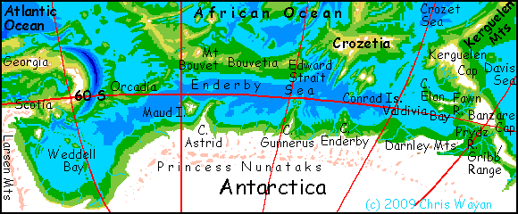
Crozetia and Conrad
Crozetia ("crows ATE ya" not "crow ZEEsha") is another stretch of the mid-oceanic rift zone; its snowy spine is rugged, but the coasts are mild. A cooler, parrot-free version of Cape Indomed to the north? Not so different; the treetop villages are just replaced by cliffside raven villages, and the valleys below are home to more cool-weather species like humans, big-brained lemurs and possibly bears. Del Caño Sound, over 1000 km long, divides this upland from Cape Indomed to the north.
To the south is Conrad, a green isle bigger than old Ireland. But far more rugged: two immense ice-capped volcanoes, Ob and Lena, preside over endless conifer forests and alpine meadows. Despite their names, this isn't Siberia. Only the highlands are snowy in winter; the coast, though its winters are cold, rainy and gray, almost never freezes. More Seattle than Murmansk. Too cold for lemurs to thrive, but gliderwolves and their larger flightless ancestors the gray wolf are common, along with short-haired elephants (hybrids between African elephants and the Antarctic mammoths to the south).
Natal Sea
North around Cape Edward into the Natal Sea...
The east coast has a warm Mediterranean climate, dry in summer--patchy woods and meadows by the shore, piny hills. To the north, the rainshadow of the Madagascar Mountains creates a rusty stretch of chaparral ridges with fewer trees, though the coastal strip is Southern Californian--fogs and light rains sustain scattered trees on the hills and strips along the creeks.
The north and northwest shore of the Natal Sea is rainier. Comoria to the north and the African Upland to the northwest, heat up and pull strong winds inland; in most years, storms and heavy rains follow for several months. Monsoon forest, with trees 50 meters tall in places.
But if we sail north up the Zambezi River (nearly twice as long as it was) we'll find that this forest thins to open woods and savanna a few days upstream. Great herds of zebra, antelope, buffalo, punctuated by the scattered exclamation points of giraffes. Cheetahs, leopards, lions hunt. Elephants roam, managing the herds and maintaining the waterholes. Unlike the other species I've postulated as undergoing a brain expansion, elephants have only changed culturally; they were already as smart as humans, just differently oriented. Their language is still hard for humans, but many speak a slow, word-by-word pidgin. Just be patient. Elephant philosophy is profound--and funny.
Fuji-sized volcanoes loom over this transplanted Africa: the highest are Mt Europa and Mt Bassas da India, but there are perhaps a dozen giants scattered for hundreds of km to the north. None are snowy except briefly in hard winters, but their cool heights and flanks offer niches for many refugee species from old Africa's uplands.
The western shore is spectacular: much as on the east side of Madagascar or the Amirante Strait, the sea here didn't so much shrink during the Big Slurp as drop vertically, revealing a giantic cliff, the Mozambique Escarpment. The ledges are green and laced with waterfalls, as the great ridge traps rainclouds... Again, a home for many of Africa's mountain species. But also a strange linear metropolis for gliderwolves and blue megaravens--new species from the Deep. They burrow cliff-villages into the Escarpment's face, ride its thermals, farm its ledges. Earth meets Siphonia along this thousand-km cliff--a border between eons. Shore of the sea of time!
Agulhas Sea
Round the tip of Cape Mozambique the land grows drier again; the Escarpment blocks most storms from the east, and winds from the west are gentle here. There's a complex, rugged archipelago in the sheltered sea between Cape Mozambique and Agulhas to the west. Greece and the Aegean Sea? But hotter and with a bit more rain, I think.
Agulhas, the largest island in the African Sea... a garden spot. Hot on the coasts, warm in the gentle hills; moderate rains. Like old Madagascar's little sister; half its size. Lemur villages dominate its uplands, parrot and raven towns along the coasts. But humans too, for the trees here aren't unbroken jungle; the understory lacks that abyssal gloom found in wetter regions.
The southern shore of the Agulhas Sea is called Bouvetia. More fjords--it's another segment of rift. Shona Bay and the Shona Lakes form a water-maze like Puget Sound, in the wedge between the Davis and Shona Ranges. Offshore is the startling Great Meteor Plateau, 3500 m high (nearly 12,000'), rising straight from the sea in walls of red rock, capped in green cloudforest and striped with white waterfalls a mile high.
Further north is an ambiguity, an important one. Schmidt-Ott Island. Or is it Cape Schmidt-Ott. Or Schmidt-Ott Isthmus? The answer matters, for it defines the boundary of the Atlantic and African Oceans and profoundly affects world trade.
Originally, I thought this long ridge running southwest from cool, misty Capetown cuts off the Hope or Cape Sea to the north, making it part of the Atlantic. But my newest maps show straits, not just saddles, between the Schmidt-Ott, Wyandot, Herdman, Discovery and Meteor Ranges. I'm not sure whose maps to trust. In general, the more recent they are, the more they tend to fragment this ridge/range. So for now, let's assume we can easily sail northwest into...
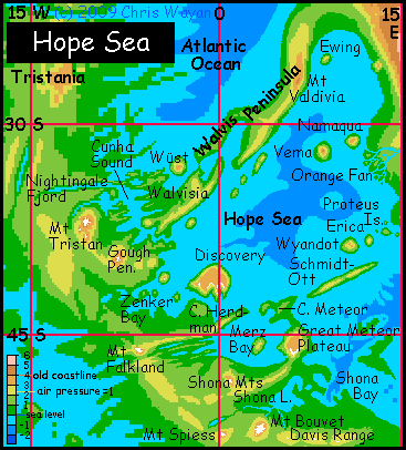
The Hope Sea
The south shore of the Hope Sea is extremely complex. West of Cape Meteor lies Merz Bay, ringed by volcanoes. Inland, Mt Falkland and the Falkland Lakes. Long Cape Herdman, probably part of the same fracture zone as Schmidt-Ott. I suspect it's dotted with volcanoes too.
Offshore, Great Meteor's western twin, Discovery Island, rears over 3 km (2 mi) in cliffs and crags from the sea to a huge, cool, misty tableland feeding hundreds of waterfalls up to a mile high. Capetown plus water--a hundred times bigger!
To the west lies Zenker Bay, then the rugged Gough Peninsula, with peaks like Mt Tristan (5000 m/16000' high)--so tall it rears entirely above the dense air of the African Basin into an Alpine zone. Tristan is ice-capped, and these aren't Ice Age remnants; the glaciers are extensive and growing.
Nestled between these rugged peaks is the sea-maze of Cunha Sound, ending in bizarre Nightingale Fjord--a cliffwalled, mile-deep, arrow-straight gash at least 700 km long (450 mi). Cunha Sound's north shore is just a few miles short of the Atlantic--but the ridge between is so steep, no sane creatures will try to dig a canal here.
The north shore of Hope is a twisting mountain range well known to oceanographers: Walvis Ridge. Like Hawaii, it probably represents the trail of a volcanic hot spot: as the plate above it drifts, the lava-plume's built a chain of massive volcanoes. I'm tentatively concluding that Walvis Ridge is the boundary between the African and Atlantic Oceans.
But it looks like there is one narrow, winding passage, Wüst Strait, through the Walvis Range. Or Wüst may be a short, sea-level valley where a canal would be feasible. There could be problems; the differences in rainfall and evaporation in the two great basins might fill one sea a little higher, creating a strong one-way current. But most factors seem to cancel out. A strait or canal would be momentous: it'd link the Atlantic and African Oceans into by far the largest surviving ocean in the world, encouraging trade from New Zealand to Labrador. The Pacific Basin would be at a great disadvantage for trade and cultural diffusion; the Atlafric Basin would dominate world civilization. (OK, Atlafric is a little awkward, but better than "Afrantic". Calm down! Nice basin!)
Cape Astrid to Weddell Bay
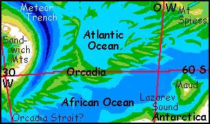
I describe the (surprisingly livable and lived-on) south shore of the African Ocean on the Antarctica page. But I want to discuss the north shore of this southern lobe--at least the far western bit on the Weddell Sea, a land called Orcadia.
The Weddell Sea is the southernmost tongue of the African Ocean, and the coldest. Its south and west shores are chilly and treeless, below the Antarctic glaciers. But the north shore is much warmer than our sub-Antarctic coasts like Patagonia, more like British Columbia, for the dense damp air retains heat at night and in winter. It also supports the wings of the most common inhabitants: giant, intelligent ravens. Their huts cling to ledges on north-facing cliffs and crags all over these coasts.
Much of the north shore of the Weddell Sea is a neck of low but rugged land called Orcadia; it's heavily wooded and warmer than the Antarctic shore, quite like temperate Europe in fact. Here, at the west end, there's a low valley leading north to the Atlantic. It seems to be just at sea level, and only 20-30 km long; a canal might be feasible. Or it may be unneeded, if there's a natural strait through the Wüst Valley, up in the Hope Sea. So is Orcadia a backwater, or one of Siphonia's great ports? I don't know. That's why this site too is marked with a "?" on the big map...
Of course, the whole question is trivial, but it exposes one of our unconscsious expectations about geography. You may have felt a certain skepticism about the maps and photos of Siphonia. They look wrong to the Terran eye--not because they're geologically wrong--they're Earth, after all!--but because geographically literate Terrans, even those raised far from the sea, know how much blue there should be, and that real land is surrounded by sea! Continuous landmasses smack of enthusiastic, amateurish cartography--inland ignorance!
The very concept of a continent arises only on a sea-flooded world like (ha! What a misnomer) "Earth", where the earth is discontinuous. On Siphonia, it'd be equally fair to say nearly all the land is continental--if you ignore our unstated assumption a continent must be surrounded by sea. In spherical geometry what does "surround" really mean? Siphonia's land and sea are so tangled they're equally inescapable... Indeed what really dominates Siphonia isn't land or sea: it's borderzones!
And any map of biomass will show you life loves a border. Neither continental interiors nor wide, deep seas are often fertile; even when they are, they're less culturally interesting than coasts. Siphonia, despite the theft of nine-tenths of its water, has gained something: an endless fractal coastline, and far more extensive maritime regions and coastal seas. My projections, in which life has rebounded amazingly well, aren't optimistic; they're a reflection of the simple fact that the area of neither land NOR water is a good predictor of an Earthlike world's fertility; total coastline is better. And that usually maximizes on worlds with relatively equal amounts of each.
I won't spend too much time on the obvious analogy of money. Most of my readers may be sure they have too little. But really, you can have too much! Drenched in money but starved for other nutrients... a life like that is a subtler sort of desert. Subtle but real. A deep-sea barrens. Enough to make anyone feel blue!
I wonder if Gaia feels blue? Maybe in her fiery spherical heart, she's wishing to be robbed. Wishing for an alien monster chef to come and steal her tasty, soupy seas. Wishing to slim down, and become bony old Siphonia.
|
|
Siphonia's homepage - map - peoples of Siphonia - Siphonia's evolution - Gazetteer
LISTS AND LINKS: More worlds? Planetocopia! - dreams of other worlds - ecology - climate change - evolution - natural disasters - terraforming - sculptures and 3D art -
World Dream Bank homepage - Art gallery - New stuff - Introductory sampler, best dreams, best art - On dreamwork - Books
Indexes: Subject - Author - Date - Names - Places - Art media/styles
Titles: A - B - C - D - E - F - G - H - IJ - KL - M - NO - PQ - R - Sa-Sk - Sl-Sz - T - UV - WXYZ
Email: wdreamb@yahoo.com - Catalog of art, books, CDs - Behind the Curtain: FAQs, bio, site map - Kindred sites