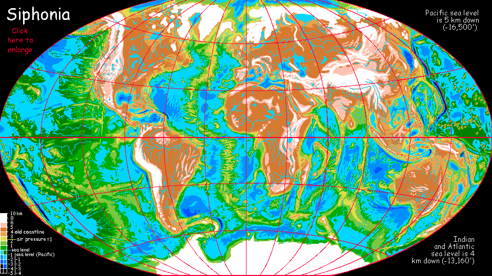
Siphonia: African Plateau
by Chris Wayan, 2006-9
Siphonia - map - regional tours - People, Creatures - Evolution - (don't click yet: Gazetteer - Glossary) - more worlds? Planetocopia!
THE RAINS ON PLAINS
ARE AFRICANLY GAINED
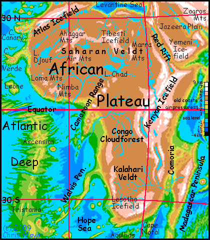
The Big Slurp that turned wet Earth into dry Siphonia had different effects on our continents; for Europe, Asia and North America, it was catastrophic. But the ex-continent of Africa, straddling the equator, actually benefited. It now stands 4-5 km (13-16,000') above sea level, but the climate isn't nearly as harsh as this altitude might suggest. Air pressure and climate are equivalent to 2200 meters high (7200' up) on Earth. The result, for a great central swath of the African Upland, is mild springlike weather year-round--rather like parts of our Ethiopia.
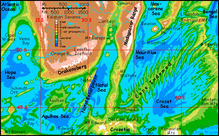
Both the Sahara and Kalahari/Namib Deserts are cooler and rainier today--mostly scrub, thin open forest, and farmable prairie below the ice-capped peaks of Atlas, Ahaggar, Air, Tibesti and Marrah in the north, the Namib and Lesotho and Malawi Ranges in the south.
This is Siphonia's biggest paradox--how a receding sea could green the deserts. The thin atmosphere's retreat into the Deeps has cooled the highlands, but that's not the whole story; the muggy basins generate stronger storms too. Though only a fraction of the Guinea Basin's torrential rains reach the plateau of the former Sahara, that fraction amounts to half a meter or more (20"). The driest spots deep inland still get at least half that--and that's better than zero. Enough to bring the desert to life!
Africa isn't the only fertile upland on Siphonia, of course. Amazonia is downright lush, and Arafura (a former shallow sea just north of Australia) is now a densely populated upland, as are the Indonesian highlands. But those regions, whether land or sea, were already fertile; Africa's deserts gained the most from the catastrophe. Well, Australia benefited just as much; just on a smaller scale.
Of course, not all regions benefit from the altitude boost. Much of East Africa now looks like Tibet, or, better, the Altiplano--alpine barrens dotted with icy volcanoes: the Kenyan Icefields. Again, it seems odd that retreating seas would replenish the snows of Kilimanjaro (and fifty other peaks that never bear snow on Earth); but though its summit doesn't get that much precipitation, Siphonia's thin air keeps it far below freezing.
Is there life here? Yes, but thin and scattered. The African Rift is low enough to be wooded in places, alpine meadows in others. Cool but lovely country. Lake Victoria resembles our Lake Titicaca; shores of dry grass. The basin's scenic in a stark way, I guess, but nowhere near as fertile as Earth's version.
I'm not going to mention the llama people here. No one believes me. I understand why--camels get bad press. I didn't believe it till I saw them. But there they are. How they got here is a long, long story. About 90,000 years long. Later.
THE RAIN DRAINS
In the northeast, the Africa Upland drops savagely, catastrophically, into the sweltering desert and caustic salt lakes of the Red Sea Rift, like a shark-bite scar in the world's flank. Unfortunately for the Red Sea Rift, most of the region's rivers flow away, toward the Nile or Euphrates, just as they would (or should I say as they wadi?) if their canyons refilled today. So I'm unsure at what altitude the Red Sea will finally stabilize--or if it will at all. As it sinks, the air grows denser, trapping more heat, evaporating more water... The Red Sea, or perhaps a mere Red Lake, may vary with long cycles of drought, salt-poisoning these coasts (and little rain falls to leach the salt away). Hard to say exactly. It will clearly be barren and hot, like today. The only question is, will it get even worse?
Beyond the Red Sea Rift, the Arabian mountains are snowcapped now; instead of the searingly hot Arabian Desert, the Jazeera Plain beyond is a semi-arid steppe, wooded along streams and in the north under the Zagros Mountains. On Earth, Arabia is part of Asia; but on Siphonia, the shrunken Red Sea no longer provides quite as clear a boundary between the two ex-continents.
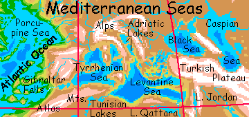
The northern Sahara and Mediterranean coast are forested, more thickly so than the Arabian plain; almost Baltic near the seas. Yes, plural: the Mediterranean Basin is a chain of small seas now, as much as two hundred meters below below the current coastline. Glacial melt from Siberia fills the Balkhash and Aral Seas, pooling in the swollen freshwater Caspian, which overflows into the brackish Black Sea (now drinkable at the surface, but don't go dredging!), then the Aegean, then the large Levantine Sea; fed by the enlarged flow of the Nile and by the Po (draining the chilly Adriatic Lakes) the Levantine overflows to the west: the brackish, sinuous Sicily River winds around Skerki Bank into the Tyrrhenian Sea, which drains at last down the long slope to the Atlantic Deep via Gibraltar Falls.
Gibraltar Falls! Endless cascades, eerily barren banks salt-poisoned by the spray; gaudy bacteria-stained streaks on the rocks and pools. A scenic wonder, but not the friendliest of sights. "Water, water everywhere, and not a drop to drink." Well, maybe I'm wrong; I'm just calculating in my head, but I get about 5 million km3 of water. The Mediterranean today is a net importer of water--more evaporates than is collected; but the cooler Siphonian seas/lakes will probably be net exporters. So let's postulate a mid-sized river, say, 100 m wide and 5-10 m deep, with a current 5-10 kph--no Amazon, more a Nile or Colorado. That still seems like enough to flush out most of the salt in ninety thousand years. Deep time! But we can't be sure; depends how much the deep strata in the larger seas mix with surface water.
Either way, the Gibraltar River may already be drinkable, if a bit brackish. Salt may still build up from the spray, poisoning trees and staining rocks with halophiles and brine. Or the monsoons of the Atlantic Deep (hotter and so more hurricane-prone than Earth's wimpy Atlantic) may have washed the salt away; the last tear-stains of Mother Earth, before she quit grieving and accepted being Siphonia.
DOWNWARD MIGRATION
The wettest parts of Africa's rim, near the drop-off into the Deeps, are cloud forest where upland gorillas may still survive where their lowland cousins once lived. No, they haven't died out either: they climbed down into the Deeps and spread around the world. The dense air of these ocean basins make oxygen-hungry brain tissue biologically cheaper to maintain, so the lowlanders have grown much more intelligent; the uplanders, though more numerous on Siphonia than Earth, are now a relic population in a double sense.
Gorillas weren't the only migrants of course. Many rainforest species migrated downstream to the warm dense damp air of the Angolan Deep, down at the new sea level. The Atlantic Basin has more land than all Africa, and much of it's rainforest. Still, it's not a wide-open frontier down there--African species will have to compete with their long-sundered cousins from Amazonia, some of them intelligent--megaparrots and giant Amazonian otters, for example.
On the other side of Africa, Madagascar is a huge peninsula now, but ecologically it's still an island. The trough between these reunited lands, Comoria, is so much hotter than ex-continent and ex-island that the two uplands remain biologically pretty distinct. Intelligent life, as usual, is an exception; lemurs took advantage of the vast new rainforests in the Indian Deep. In that rich oxygenated environment they've been quickly catching up with their cousins the great apes--the same phenomenon that led in the New World to intelligent Amazonian otters.
Southern Africa ranges from semi-arid high veldt rather like North America's High Plains, to a quite Canadian highland in the far south; conifer forests slowly rising to the long Lesotho Icefield. The south face of the mountains are a sudden, savage escarpment, the Drakensberg. In a hundred miles, the land drops 7-8000 m (23-26,000') to Mozambique Sound, an arm of the Agulhas Sea. It's as abrupt as the Himalayas and nearly as tall.
Africa's population as a whole is dense today. It's mostly apes (including humans) and elephants, with a few settlements of Amazonian otters along western rivers like the Niger and Congo, and lemurian pioneers in the southeast, in the Comoro Trough. The air's just too thin to be comfortable for intelligent fliers like the giant parrots who dominate the Atlantic Deep to the west, or the mega-ravens of the Deeps to the south.
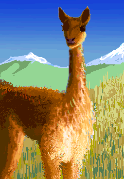
One people I certainly didn't expect to see here are the llamas. As the Altiplano iced over, llamas and their woolly cameloid cousins--guanacos, alpacas, vicuñas--all fled downhill (as did every Bolivian with a brain). They settled the Amazon Upland, the coastal mountains of Brazil, and Patagonia Steppe.
Over the millennia, one group spread further south, into the cool hills of the Scotia Deep--warm and damp for a llama, but cooled by the (remaining) snows of Antarctica, they were tolerable. Llamas adapted. In the southeast, the receding sea left an isthmus, called Orcadia, leading to the lands along the rift zone on the floor of the South Atlantic--Bouvetia and Tristania to the north.
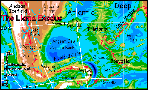
In those cool but oxygen- and food-rich highlands, llamas evolved--and spread. Their ancestral stock had already been bright, but the creatures that discovered the Walvis Mountains, a landbridge to the cool highlands of South Africa, were debatably people, if primitive. The new altiplano around the Lesotho Icefield became their homeland.
Twenty thousand years later, a small herd of their literate descendants crept north along the Malawi Mountains to explore East Africa's cold highlands, where they flourished.
One bold group even listened to gorilla tales of snowy mountains to the east, in the African Deep. Unlikely, but they chanced it, descending into Comoria--the old channel between Africa and Madgascar, now a hot savanna studded with tall volcanos. Like shaggy Polynesians hopping island to island, the llamas settled one volcano after another. They took generations to reach the prize--Madagascar's highland. Cooler than today, and far larger; sweeter grazing than the altiplano ever was!
|
|
Siphonia's homepage - map - peoples of Siphonia - Siphonia's evolution - Gazetteer
LISTS AND LINKS: More worlds? Planetocopia! - dreams of other worlds - ecology - climate change - evolution - natural disasters - terraforming - sculptures and 3D art -
World Dream Bank homepage - Art gallery - New stuff - Introductory sampler, best dreams, best art - On dreamwork - Books
Indexes: Subject - Author - Date - Names - Places - Art media/styles
Titles: A - B - C - D - E - F - G - H - IJ - KL - M - NO - PQ - R - Sa-Sk - Sl-Sz - T - UV - WXYZ
Email: wdreamb@yahoo.com - Catalog of art, books, CDs - Behind the Curtain: FAQs, bio, site map - Kindred sites