Siphonia:
AUSTRALIAN OCEAN
by Chris Wayan, 2006-9
Siphonia - map - regional tours - People, Creatures - Evolution - (don't click yet: Gazetteer - Glossary) - more worlds? Planetocopia!
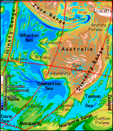
Australian Ocean: Overview
Three great seas make up the Australian Ocean: The Wharton Sea, The Diamantina Sea, and The Tasman Sea. A fourth, the Davis Sea, might also be linked to the complex; for now, it has its own page.
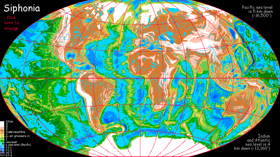
It's difficult to generalize about these three seas--they have little in common, offering drenched jungles and desert shores, fierce heat and subpolar waters. They only share one feature, their altitude, around 4 km or 13,000' below our current sea level. That's a bit arbitrary, since the Australian Ocean is cut off from Siphonia's other oceans by high ridges; during the Big Slurp, the basin wouldn't have drained much past 3 km down. I'm relying on evaporation for the last kilometer--approximately. The Tasman Basin is hot and dry; water lost there might offset all the rain falling on the Wharton Sea.
But evaporation here is really a euphemism for authorial laziness. I wanted this ocean 4 km down partly to give them the same level and thus air density and general characteristics as most of the new oceans, and partly because a coastline precisely N kilometers down is much easier to map, given the crude bathymetry available to me here in the informational Dark Ages. Even these round-number coastlines I'll be showing you aren't terribly accurate, but at least they'll give you the general layout.
Just wanted to warn you. Sea levels here could be much higher--high enough to spill over the lowest pass of the Ninety Range into the Bengal Sea, or fuse with the Davis Sea and spill over the Amsterdam Hills into the Crozet Sea (like Bengal, a lobe of the African Ocean), and/or swallow Lake Bellona northeast of Australia and spill over Marion Pass and down a chain of salt lakes into the Pacific. It's hard to say which sill is lowest; they're all around a kilometer higher than the sea level I've shown.
My guess is this wouldn't happen; just not enough water. But I can't be sure. We just don't have seas like the Wharton, both evaporating and collecting a hurricane's worth of water everyday, nonstop.
Let's tour these uncertain, cut-off seas from west to east, north to south...
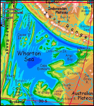
The Wharton Sea
The Wharton Sea is in the torrid zone--but we pre-catastrophe cultures don't know what torrid means. Scorching heat! The dense air and tropical sun in this deep basin makes it a heat-trap. Heavy evaporation, 100% humidity. Contemporary humans would find it an uninhabitable steambath. But Culture abhors a vacuum just as much as Nature does, so expect giant intelligent parrots to build villages in the crowns of Wharton's rainforests. They'll trade with the big-brained Amazonian otters that dominate sea-trade all over Siphonia's abysses.
The climate? Constant hurricanes! They're less frequent in winter--that is, about like our worst hurricane seasons. Summers are just storm, sun, storm, sun. Rainfall on the islands and along the coasts must be measured in meters--ten to twenty meters, in places. Wharton's windspeeds are lower than our hurricanes, rarely over 100 kph, but remember the air's denser; they pack nearly as much punch as Terran hurricanes, and they're relentless. Folks build their huts light and flexible. Or dig caves. Anything else, the roof rips off.
Rainforest covers the slopes of the Ninety Range, Java, Brokenia, Cape Wallaby and the Cuvier and Exmouth Plateaus, even the edge of the Australian Plateau--which is a cool, high forest, sparse and scrawny, but forest where in our world the Great Western Desert once sprawled.
You wouldn't think siphoning water away would green a dry continent! But the sharp temperature gradients between the ex-continents and the newly exposed sea-basins generates strong monsoons all over Siphonia; and the Wharton is one of the strongest.
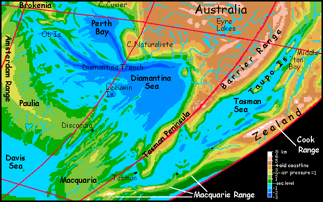
The Diamantina Sea
Diamantina, in the temperate zone, is cooler and drier than the steaming Wharton basin, but still warm due to its dense air. The chains of long islands paralleling the Diamantina Trench are much like our Caribbean islands--Ob could almost be Cuba, except for the huge birds and flying mammals. The basin's prone to quite Caribbean hurricanes too, especially in the north, but it's not like the Wharton's steady barrage. I think the Diamantina will be the population center for the region--good habitat for both upland creatures like humans and basin dwellers like the giant intelligent parrots and big-brained Amazonian otters dominating Whartonia.
It's likely but not certain that a natural channel cuts through the Australian-Antarctic Discordance, that jagged fracture zone visible on Diamantina's southeast shore. If it exists, the strait leads south into the Davis Sea; and if not, the westernmost of these cracks is so close to sea level that digging a canal would be feasible. A third possibility is that the cool rainy Davis Sea may get enough precipitation and so little evaporation that it spills through this crack in the Discordance with no prompting at all. Whichever hydrological scenario is correct, shipping will funnel through Discordance Valley; it will be the hub of trade for four seas: Wharton, Diamantina, Davis and Tasman. Expect a major, cosmopolitan port city or city-state called Discordia, with all the intelligent species of the hemisphere represented. Despite the name, it's probably a fun town: scenic, with mile-high crags east and west; culturally diverse; and with a warm, pleasant, rather Mediterranean climate.
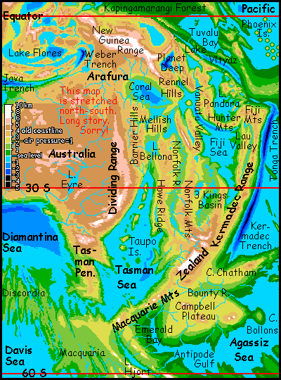
The Tasman Sea
Both my current maps foreshorten the Tasman Sea badly. It's really quite a broad leaf-shape: narrow in the north, in Middleton Bay, but over 1000 km wide in the center and south.
The Middleton region may be biologically narrow, too: its shores are likely to be as dry as the Red Sea, or at least the Sea of Cortez. One great river does down from Lake Bellona and the Mellish Hills to the north, but otherwise there should be little runoff. That means high salinity, but most of the time, no sediment in its clear waters either. Reefs here will be rich with life--rocks, shallow water and lots of light. A splendid nest for a nascent octopoid civilization!
"Oh, but they're too shy and antisocial" you say... Oh, come on! If you're reading this you're a webnerd, aren't you? You'd make a fine octopus yourself! At least if you like sushi, and kinky sex (look up octopoid mating sometime. Ow, ow, ow. You'll never date one again.)
Oops. Where was I? Oh, three miles down in the Tasman Deep, right...
Further south, below the Cook Range, the Tasman coast is nicer, rather like California's coast--hot, and rainy in season, but not shockingly alien like most of the Deeps. Humans and the newer Deep-adapted species coexist here and further south: air pressure is dense enough for megaparrots and ravens, while temperatures are human-tolerable.
The temperate south end of the Tasman Sea looks temptingly close to the Agassiz Ocean in the Pacific basin, but there is no natural channel, and a canal's impossible. The Agassiz is fully a kilometer lower, and the Macquarie Range between the seas stands 3-5 km tall (2-3 mi); even the lowest passes appear to be nearly 2 km high (over a mile). Canals and natural straits link most of the seas in the old Atlantic and Indian Basins, allowing hemispheric sea-trade; but shipping (and sea life) in the seas of the old Pacific Basin are likely to stay separate forever.
But shipping isn't the only form of travel on Siphonia. Abyssal fliers like giant parrots, ravens and gliderwolves are the fastest means of communication and shipping (for light items and airmail at least) on the planet. They generally find flight exhausting (impossible in the case of gliderwolves) at continental heights; they're restricted to the abyss. Their Siphonia has oceans and straits of flyable air, not water.
For these abyssal fliers, Emerald Pass over the Macquarie Range is vital. It lets them travel, though with effort (and screeching obscenities in the case of parrots), between the Australian Ocean complex and the vast Agassiz Deep to the east. For dwellers in the abyss, it�s a strait between hemispheres; their Cape Horn.
But travelers to most of the old Pacific basin will head north, up the Middleton River to Lake Bellona, and over Marion Pass to the Coral Sea, and down to the Pacific. Marion Pass is only a kilometer high or so--much easier. An antipodal Panama! But that's another tour: of the Anzac Basins.
|
|
Siphonia's homepage - map - peoples of Siphonia - Siphonia's evolution - Gazetteer
LISTS AND LINKS: More worlds? Planetocopia! - dreams of other worlds - ecology - climate change - evolution - natural disasters - terraforming - sculptures and 3D art -
World Dream Bank homepage - Art gallery - New stuff - Introductory sampler, best dreams, best art - On dreamwork - Books
Indexes: Subject - Author - Date - Names - Places - Art media/styles
Titles: A - B - C - D - E - F - G - H - IJ - KL - M - NO - PQ - R - Sa-Sk - Sl-Sz - T - UV - WXYZ
Email: wdreamb@yahoo.com - Catalog of art, books, CDs - Behind the Curtain: FAQs, bio, site map - Kindred sites