Siphonia: Caribbean Lakes
by Chris Wayan, 2007
Siphonia - map - regional tours - People, Creatures - Evolution - (don't click yet: Gazetteer - Glossary) - more worlds? Planetocopia!
Caribbean Lakes
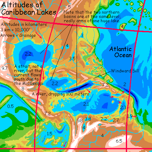
The Caribbean Sea, like the Javan Seas, has become a chain of great, deep, high-altitude lakes. The island arcs off Central America had no deep gaps like, say, the Scotia Basin off Patagonia, through which the water could drain. Not to say the coastline's the same. The old Gulf of Mexico and the northern Caribbean Sea, off Cuba, have dropped 1800 meters (well over a mile). But they're still a continuous sheet of water--one huge lake, really, though I've dubbed the two lobes Lake Mexico and Lake Cayman. The southern Caribbean, south of Jamaica, is a truly separate great lake, about 100 meters lower.
When I say "lakes" I mean it. These ex-seas are drinkable. The Mississippi is the world's second largest river, by flow, pouring so much fresh (if muddy) water into the former Gulf that the salt flushed out in a mere 50,000 years, at least in the surface layers. While the Yucatan Strait is a broad channel, not a river, the flow is consistently south due to the Mississipi's inflow and the higher evaporation in the warmer south. Lake Cayman is really just the southern arm of this great lake, and it too is fresh, except in the depths of the Cayman Trench, still around 5500 m deep (18,000'), where cold, heavy brine huddles like a hibernating bear deep in its den.
I have my doubts about the freshness of the new Mediterranean Lakes (see Africa), for the flushing action isn't as great; but a river as big as the Mississippi can do a lot over deep time.
The great northern lake nearly spills out to the Atlantic at Windward Pass between Cuba and Haiti; but there's a slightly lower sill leading south instead, past Jamaica into the southern Caribbean. This too is fresh water, for it spills out to the Atlantic through a still lower lake between the peaks of the former Virgin Islands.
So... have the coral reefs of the Caribbean all died? Well, obviously the originals did: they're now limestone hills over a mile high. But do the shallows of the new lakes teem with similar freshwater reefs? Well, no. Fresh water lacks the calcium to build massive reefs, though the runoff from all the old reefs makes Caribbean freshwater pretty hard stuff. But species not dependent on shells certainly thrive; the broad lake-shallows seem with life. Salinity dropped slowly, and there's still plenty of rich mud entering the lakes, sun to add energy, and hurricanes to stir up the water; and, perhaps surprisingly, the temperature's much the same.
For the water dropped nearly two kilometers; while the loss of Earth's seas caused the atmosphere to pool in the new deeps, turning former continents into chilly plateaus, here the air pressure is only a little lower it was before the Big Slurp. That's cooled the surface water a bit, but it's still warm enough to feed large tropical storms--and also, some monster storms make it over the mountains from the steamy Atlantic Deep to the east. Very few places on Siphonia have changed this little--the China Sea and Lake Andaman are two, and for the same reason: they dropped about two kilometers, just enough to compensate for the thinner air. Dumb luck, really.
So climates on Siphonia's Caribbean shores aren't so different from Earth's. With one difference: inland, the land rises to rugged mountains 2200 m (7000') higher than ours. Haiti really can field a bobsled team at last: Mt Duarte's crowned with glaciers now, for its Atlantic face is of Himalayan height; even the Caribbean side rises 5100 m (16,700') above the lake, as tall as Mt Ararat. The mountains of Mexico and the Marta Mts on the Venezuelan shore stand taller still--the Martas, already spectacular in our time, are now the hemisphere's tallest peaks head-to-foot, some 7.7 km (over 25,000'); a great icefield above the tropic shore.
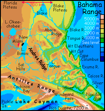
Bahama Mountains
Though not the tallest mountains in the region by any means, the Bahamas are still Alpine in height and more than Alpine in ruggedness. Their feet are steamy, for they rise from the Atlantic shore: rainforest unlike any on Earth, with average temperatures 40 C (104 F) or higher, and 100% humidity. The lower slopes are lashed with hurricanes all summer and lesser storms all winter. As on the rainy side of Polynesian islands, the storms dissect the slopes into knife-ridges and near-cliffs; only the mat of dense jungle keeps the land from washing into the sea entirely.
But steep, rugged, winding valleys lead into the heights. These aren't raw new river-canyons, they were here before the seas dropped--cliffwalled azure deeps like Tongue of the Ocean and Exuma Sound were visible from space. Now, bared, limestone crags and cliffs up to 7000' tall loom over these canyons, sheltering them from the worst of the storms; and midway between the deeps and the peaks, canyon temperatures are springlike year-round. In fact, the Tongue and Silver Valleys still have the old, mild Bahama climate--it's just the scenery that's changed. Above, the old coral reefs are now jagged cliffs and spires, misty and cool (though never snowy). Cloud forests and fern-alps cling to the rocks, which are porous and full of caves. Surface water in the heights tends to sink in; cave-streams seep through the limestone til they hit underlying volcanic rock, then burst from cliff walls in ribbon-falls.
It's a land like a Chinese scroll--but compared to the Karst limestone fields of South China and Vietnam (the inspiration for the ancient painters) these Bahama crags are triple-sized. Scenic but surreal... and, as I'll explain in the next section, likely to get more so.
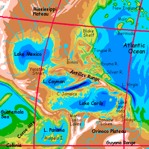
Lakes Mexico and Cayman
The relatively gentle slopes of Lake Mexico are all pretty much the same--a great, simple, oval basin, with rivers cascading down escapments 1-200 km inland, then running down long coastal slopes to the sea.
Lake Cayman is a bit more complex: itself two-lobed, the northern half relatively shallow, indented, island-dotted. Rich marshes surround the lake; instead of coral, freshwater grasses cling to the rocks; further out are kelp-like algae forming underwater forests. Here the big-brained descendants of Amazonian otters farm fish, oysters, freshwater clams, cattail reeds and waterlilies for their huge pods of tasty seeds. They didn't evolve here of course; their great leap forward was in the oxygen-rich jungles and lakes of the Atlantic Deep. These are pioneers at the edge of their ecological range, still adapting to the thin air and relative cool--merely Earth-tropical!
The southeastern half of Lake Cayman is simple and brutal--a deep slash, the old Cayman Trench, still 5 km deep: the deepest water in the world. The shores are mostly straight and rocky, dropping off fast into azure depths. In most places the warm coastal plain rises quickly into cool, mild, misty highlands: cloud forest, though opening to fern-meadows on some west-facing slopes. Though rainy, it's not torrential like the torrid Atlantic Basin to the east. These wooded hills are most probably gorilla, chimp and bonobo country. In 90,000 years, they spread across the forests of the Atlantic Deep. Like the otters, they grew larger and larger brains in that oxygen-rich lowland. There is no land-bridge across the Atlantic, even after the Big Slurp, so at some point, either humans or otters must have offered ship-passage to the New World shores, where they flourished. Like the otters, these apes too are pioneers.
Are there humans here? Oh yes, farming the flatlands around the shore and on the Pedro and Jamaica Plateaus. They just cede the deep forests to peoples able to enjoy the bright canopy above; the forest floors are gloomy, protein-poor platces anyway. What--clear the forests and farm, build plantations? Why, when the apes can harvest treetop produce directly? It's cheaper for all concerned to simply trade.
The most notable feature of South Cayman is a geological time bomb. At the east end, the Windward Gap is a low pass leading down to the Silver Valley in the Atlantic Basin, 2100 m (nearly 7000') below. The Silver Valley gets constant storms off the Atlantic, and Windward Creek's head is steadily gnawing away at the pass. When it lowers the sill another 100 yards, the whole Mississippi/Mexico/Cayman system will start pouring down the Silver River instead of feeding Lake Carib. The torrent will create a chain of Niagaras and Iguazus--and unlike the brackish Gibraltar Cascades, these will be fresh and verdant. Just one more reason to visit the Bahama Range!
Few large rivers feed the Carib, and its level will drop slightly; more significantly, its outlet, the Virgin River, will shrink from a chain of Niagara-sized falls and cascades to a much more modest river. Still scenic, but the thunder will be gone.
Don't change your itinerary yet; it'll be thousands of years before the Windward Sill finally fails.
Pirates of the Caribbean!
There are pirates of the Caribbean, though only on the northwest shore, from Maiz Bay and Lake Providencia in the west to the Roncador Islands off Serrana, Alice and Nuevo Bays. This shallow maze of bays capes and islands is another frontier for big-brained otters, though human fishing villages still dot the shores. But they really can't compete with the otters' aquaculture. Not fairly, at least; but oyster-rustling and nocturnal lotus-swiping are rampant. Since just trading farm- and forest-produce for lake-produce is more efficient, piracy is doomed in the long run; but traditionalist humans, who have "always" fished here, haven't yet accepted economic change; few villages, ship-crews or aquafarms here welcome both species, though it's the obvious solution: anthropoids to climb things, musteloids for swimming. Sorry to disappoint you about the pirates. The only gold is those lotus seeds--very tasty, but not what you hoped, I suspect. Pilfering and ethnic resentment--not a glamorous story, or a new one. My sympathies are with the otters.
The northeast is hillier, more human country: the Pedro Plateau, then Lake Portland and Jamaica Bay, the narrow sound where the short (only ten km!) but broad Jamaica River feeds the lake. Really, the Jamaica is a continuation of the Mississippi far upstream; and to the east, past the Beata Islands, the outflow into Virgin Lake should be considered another stretch of the same long river. Indeed, if you start at the source of the Missouri, it's one of the longest rivers on Siphonia: nearly 8000 km (5000 mi). The last stretch is very different; as mentioned above, the Virgin River east of the lake is a steep, short river with all the punch of the Mississippi behind it, dropping 2 km (6600') to the sea in a series of Niagara-like falls and cascades. In the hot, humid air of the Atlantic Deep, the cold spray lingers as a standing wave of mist, a worm of cloud over the tormented river. If you could see it, or anything further than ten yards off, it'd be quite a sight. And is, on the one clear day out of ten.
The eastern shore is not where it was. The receding water reveals a hidden ridge, Aves Ridge, parallel to the Lesser Antilles, now a great mountain range. Between them nestles Lake Grenada, larger than Lake Erie. Lake Tobago, over the mountains to the west, may look similar but it's not: this is the stormy side of the mountains. Hurricanes batter these slopes constantly. The Tobago River's flow is nearly half that of the Mississippi! Like the Virgin, it's a twisting series of Niagaras lost in mist.
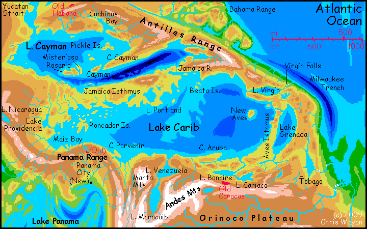
The southwest coast is steep and rugged; mountains rise 3 to 4 km above the sea, almost high enough for snow. Inland, you can remove the "almost": though nearly equatorial, this Venezuelan spur of the Andes Wall rises 4-5 km above the Orinoco Plateau, and 6-7 km above lake level: that's 20-23,000'! Ice and thin air make them nearly impassible. A lone outcrop of this Himalayan zone stands directly on the southwestern shore: the Marta Range. Already spectacular in our time, they're now the hemisphere's tallest peaks head-to-foot, some 7.7 km (over 25,000'). Visible over the whole western basin, they generate weird weather--katabatic mistrals off the icefields, storms wrung from clouds forced miles higher than their neighbors, and an arc of rainshadow desert on their southwest slopes.
Snowy mountains nearly as high ring Lakes Venezuela and Maracaibo. The nearest thing our world offers are the northern, higher African Great Lakes, but it's a weak analogy; except for Ruwenzori and Kilimanjaro the African mountains are snowless. But these lakes, especially Maracaibo, are fertilized by glacial silt from the icy peaks above. The water is milky; all photosynthesis must happen in the first few yards down, but it's loaded with nutrients from the rock flour. The coastal flats are mild year-round, ideal for humans, who farm the shores intensively.
The far southwest shore of Lake Carib is a steep S-shaped wall: Panama. The mountains are much higher and cooler now, of course, but still snowless, except for a few of the tallest volcanoes in the far west. Cloud-forest ridges and Caribbean valleys: a pleasant strip, but narrow. Just over the mountains, however, the land falls away, and the rains become erratic--a torrential monsoon some summers, but a mere drizzle in others. This shouldn't be a shock to anyone who's read of the Galapagos: surrounded by water and on the equator, but also downwind of our Andes, which harvest most of the rain. I'm oversimplifying of course, but Lake Panama, deep in the basin south of you, just isn't enough to re-humidify air that's been freeze-dried over the Andes Wall, which, climatically, is several kilometers higher than our Andes; a second Himalaya.
The Amazon Plateau's gain is Panama's loss: the gentle Caribbean ecosystem ends abruptly here.
|
|
Siphonia's homepage - map - peoples of Siphonia - Siphonia's evolution - Gazetteer
LISTS AND LINKS: More worlds? Planetocopia! - dreams of other worlds - ecology - climate change - evolution - natural disasters - terraforming - sculptures and 3D art -
World Dream Bank homepage - Art gallery - New stuff - Introductory sampler, best dreams, best art - On dreamwork - Books
Indexes: Subject - Author - Date - Names - Places - Art media/styles
Titles: A - B - C - D - E - F - G - H - IJ - KL - M - NO - PQ - R - Sa-Sk - Sl-Sz - T - UV - WXYZ
Email: wdreamb@yahoo.com - Catalog of art, books, CDs - Behind the Curtain: FAQs, bio, site map - Kindred sites