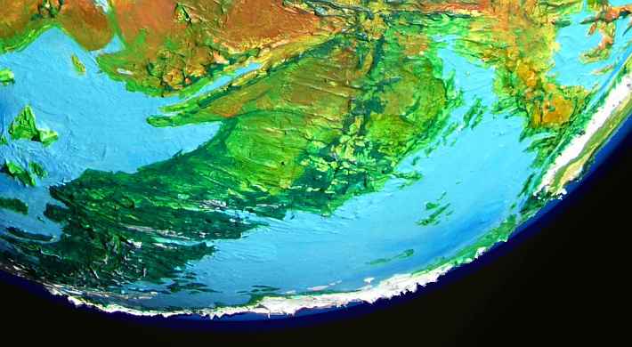
Siphonia:
Mornington Sea and Scotia Deep
by Chris Wayan, 2006-9
Siphonia - map - regional tours - People, Creatures - Evolution - (don't click yet: Gazetteer - Glossary) - more worlds? Planetocopia!
Overview
Perhaps these should have separate pages: The Scotia Deep, while only two million square kilometers, is a spectacular region, geologically hyperactive, and a bottleneck through which much trans-hemispheric trade and news must pass: the tail that wags the geographic dog.
In contrast, the Mornington Deep is sprawling, fertile, gentle and less scenic, and probably rather rustic. It's cut off from world trade; the Pacific Deeps to the northwest, the Australian Deep to the west, and the Atlantic Deep to the east, can only be reached over mountain passes at least a mile high.
It may be practical to dig a canal opening up shipping to and from from the smaller Nazca Deep to the north, creating a regional trade zone nearly oceanic in scale; but it's still a Siphonian backwater. A fertile one, though. Rainfall and temperatures are moderate throughout; this is healthy land.
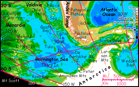
Mornington Sea
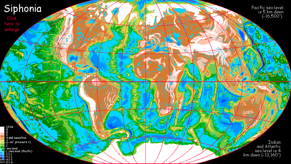
Most of Siphonia's seas lie about 4 km (13,000') below the sea levels of old Earth. The Pacific Basin is the largest exception: its two main seas, the Pacific (old North Pacific) and Agassiz (south-central Pacific) are fully five km down (about 16,500'), with dense air and hot climates. Mornington Sea, in the southeast corner of the old Pacific basin, is an exception to the exception: the largest Pacific remnant that's only 4 km down, the same altitude as the Atlantic or African Oceans.
That's still deep enough to warm up its climate substantially; for a sea practically licking the toes of Antarctica's glaciers, it's very mild. This mix of high latitude and low altitude leaves the basin with quite Earthlike temperatures--unlike the steamy Agassiz or Pacific. Rainfall ranges from moderate to heavy; in this region, the green on the altitude maps matches the reality on the ground: its long coasts are all solidly wooded, though the forest is arctic and thins quickly inland on the south shore. Think Alabama at the north end, grading slowly to Newfoundland on the south.
The western shore, Menardia, is steeper, broken country, rising slowly to a winding ridge 2-3 kilometers high, broken by long deep cliffwalled valleys and ridges. South of the Menard zone itself lies Eltanin, with long Lake Heezen in its depths, then a twin, Tharp Valley, over a ridge to the south. A few hundred km further south is Udintsev Fracture, also with a long lake. These long cliffwalled sounds and lakes resemble fjords but are carved not by ice but by fire: the ridge is a spreading rift zone, and as it bends, cracks grow out at right angles to the rift, like cracks in a carrot that grew too fast.
Two or three million years ago, back before Siphonia's seas got siphoned, a catastrophe hit what's now the Tula Islands in the central Mornington Sea--a metallic rock at least a kilometer across (maybe two or three!) hit an ancient seamount's flank, blasting a crater some 30 km wide. Today it's a horseshoe bay with twin craterwall headlands and islands offshore. The impact was much smaller than Chicxulub (a TEN-kilometer rock, certainly 100 times the mass and likely much more), but it was enough to cause tsunamis worldwide. Any traces today? No. The basin's as rich and diverse as any at this latitude.
I mention the impact mainly because I had to toss a rock at Siphonia; Siphonia is Earth. We got hit at that time and place; it's called the Eltanin impact. But as Ice Ages came and went, the sea rose and fell, erasing most evidence; only meteoric nickel-iron found on the seafloor proves what struck us. Biospheres heal such wounds rather quickly.
Book-critique time! Mary Robinette Kowal's science fiction novel Calculating Stars (and sequels) describes a near-identical impact, though she aims it near Washington DC for maximum human drama. I'll grant that it's a gripping picture of a disaster... but the climatology is laughably wrong. This modest oceanic impact causes runaway greenhousing--vapor heats ocean creates more vapor--supposedly ending with boiling oceans! Because a zillion previous rocks NEVER hit the sea? Please. And in deep time Earth's NEVER been hotter or steamier, can't take the heat? Please. And those new clouds wouldn't cool us off again? Please. We're on the verge of catastrophe, and this dinky rock will kill all life on Earth! Kowal thanks an astronomer (who I mercifully won't name) for "explaining" how one pebble will destroy the world. The thrill of catastrophism makes even smart people throw out common sense.
Hunt all round the Morningtonia shores--you won't find a single sign of this recent impact, unless you visit the Tula Islands just to see Crater Bay. It's scenic. But biologically and climatically, Eltanin might as well never have hit.
The flora here in Morningtonia may be familiar (if luxuriant for the latitude) but the fauna might look strange. Air pressure isn't as high as in the other Pacific basins, but it's still over 50% denser than our sea level--high enough to encourage gigantism and flight in animals. In the north, megaparrots are probably the most common people, giving way to equally huge ravens in the south; giant Amazonian otters are common in every port--it's the cool end of their range, but mild enough for them except on the Antarctic coast. I'd expect gliderwolves all round the sea--coyote-sized canid people gliding on skin flaps, like our flying squirrels.
Humans are common all round the Mornington, but the only other apes are orangutans, in the north, immigrants from Borneo, via the new jungles of the Pacific Deep; chimps, bonobos and gorillas haven't yet made it around the icy stratospheric wall of the Andes.
Mornington Basin may not be totally isolated, though. The shallow southern end of the Andes Trench forms Pactolus Sound and Drake Passage. Running to the north, there's a stretch so shallow it's a mere valley, just above sea level, leading to the Nazca Sea about 100 km to the north. If you have a boat with short enough keel to sail up the small Taitao River, it'll take you to within 30 km of the Fernandez River, draining north into the Nazca Sea. The land between them is low and flat. Linking these two large seas wouldn't be hard, at least for boats with shallow draft. Such boats could also reach the Scotia Deep to the southeast via Drake Channel, and possibly even Lake Panama in the far north past Nazca. This navigable trade basin, though artificial, would rival some of Siphonia's natural oceans, and reach from the equator to the edge of Antarctica.
Given the canals that the preindustrial Greeks and Chinese managed to dig, and that conditions shouldn't be too difficult--it's no Suez Desert or malarial Panamanian jungle--it does seem likely that the Fernandez Canal would eventually be dug. If the locals are motivated. Will they be? If most of the locals are avians, or gliding or flying mammals--as seems equally possible in the Deeps--they may disdain such slow, dull voyaging. At least until they want to trade goods in bulk! On the other hand, humans and Amazonian otters will most likely be common in the cooler Mornington basin, and they'll be motivated to dig a canal even if the Nazcan parrots and gliderwolves just ride the thermals above them, laughing at the silly groundhogs...
Scotia Basin
This geologically tormented region is like nothing on Earth. Except itself, I mean--hidden, in our world, under 2-3 miles of brine. Exposed, it's a basin hard to sum up in a paragraph or two.
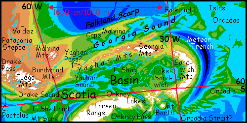
A horseshoe of mountains surrounds it: the Grahams and Scotias in the south, the Sandwiches in the east, and the Yaghans and Georgias in the north, where Mt Paget rises nearly 7000 m (23,000') high. Even in the north, peaks much above 3 km (10,000') are icecapped, especially on south-facing slopes, and in the south, on the edge of Antarctica, some glaciers creep as low as a kilometer.
Yet the basin's climate is mild for its latitude: air pressure is 1.5 atmospheres, trapping heat. Winter snows are not severe, and summers can be warm.
A maze of narrow sounds wind through the northern half of the basin, paralleled in the south by a set of freshwater lakes. The largest, Lake Shetland, is nearly 1000 km long, as big and deep as our Lake Baikal. Conifer forests hug the lakes and sounds, fraying to alpine meadows on the heights. It's vaguely Scandinavian, but with milder winters, due to the dense air.
Here too, populations are mixed: mega-ravens, giant otters, and humans on the coasts, thinning to a purer human population in the hills, where the air's too chilly for otter and too thin for megafauna to fly comfortably in.
But perhaps another couple of species may join the mix here. Even in our day Arctic wolves have brains rivaling great apes. With expanded habitat and more oxygen (and perhaps a little genetic tweaking) , they may have grown into full intelligence. These flightless mega-wolves would spread down the long cool highway of the Andes from their homeland in the former North America. The Scotia hills would be ideal for them.
The other people I picture here are even more exotic: reintroduced mammoths. This would be an outlier population, a northern finger of their real heartland, the treeless but living shores of Antarctica, where I describe them in more detail. But they're worth mentioning here. The extensive alpine highlands of the Scotia Arc would be mammoth heaven...
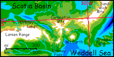
But all this is naíve. Dazzled by the ecological forces at work here, I lost track of my core thesis: how geography itself, not just climate, shapes life and civilization. I've been writing as if Scotia were isolated, and it can't be. It's a flyway! The lowest paths between the sundered hemispheres lie here, over Yaghan Pass in northern Scotia, and even lower Orkney Pass in the southeast near Antarctica. No canal will ever cut through, linking the Mornington and Nazca Seas to the Atlantic and African Oceans--even Orkney's over a kilometer high. But the fliers of the abyss--gliderwolves, megaravens, and even megaparrots, will flock here. It's worth coming thousands of km out of the way--what's that to them, a few days of adventure on the wing? Much better than being earthbound for weeks on some wretched groundhog caravan, constantly gasping in the thin air of the ex-continents to the north!
I try hard to be a birdbrain, but I can't transcend my winglessness; I see land-passes and sea-straits readily enough. But for the winged, Scotia is the vital strait between hemispheric oceans of air.
Not that the parrots appreciate Orkney Pass as they shiver and climb, whether on wing or on foot. The wind's cold, the snow's awful, pine nuts taste of turpentine, they're exhausted, you call this stuff air? All at 100 decibels, of course.
The result? Every spring in Orkney Pass, parrot kvetching triggers avalanches. The mortality rate rivals Skagway Pass during the Yukon Gold Rush. But that lasted only a few years--Orkney's parrot peril is, pardon my alliteration, perennial.
Gliderwolves? Ravens? Oh, they just scrabble up the pass in sensible silence and glide down laughing. Lands may change, seas may die; but cynicism, now that's robust.
|
|
Siphonia's homepage - map - peoples of Siphonia - Siphonia's evolution - Gazetteer
LISTS AND LINKS: More worlds? Planetocopia! - dreams of other worlds - ecology - climate change - evolution - natural disasters - terraforming - sculptures and 3D art -
World Dream Bank homepage - Art gallery - New stuff - Introductory sampler, best dreams, best art - On dreamwork - Books
Indexes: Subject - Author - Date - Names - Places - Art media/styles
Titles: A - B - C - D - E - F - G - H - IJ - KL - M - NO - PQ - R - Sa-Sk - Sl-Sz - T - UV - WXYZ
Email: wdreamb@yahoo.com - Catalog of art, books, CDs - Behind the Curtain: FAQs, bio, site map - Kindred sites