THE SOUTH
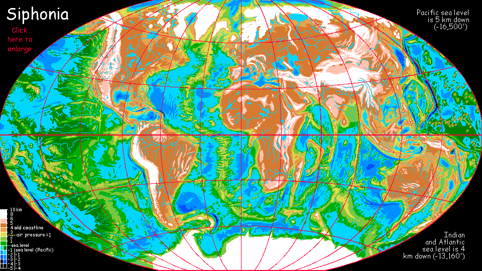
Siphonia:
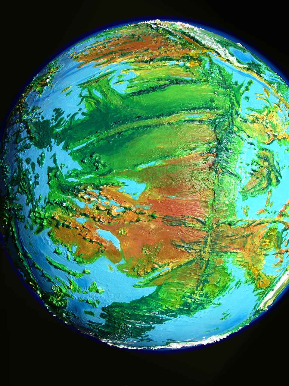
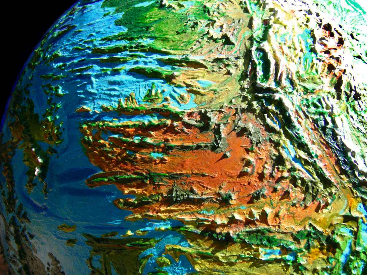
Nazca Seas
by Chris Wayan, 2006-9
Siphonia - map - regional tours - People, Creatures - Evolution - (don't click yet: Gazetteer - Glossary) - more worlds? Planetocopia!
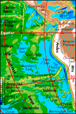
NAZCA SEAS
This page covers the half-dozen small seas west of the Andes and Central America. It's a sprawling, complex region with unclear boundaries, and eventually I may build a separate page for the northern part: the Guatemala Sea and possibly even Lake Panama, the Albatross Range, the Clarion Lakes and Clippertonia. But for now, you'll find these here too, in a section called THE NORTH.
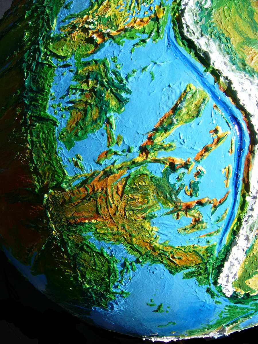
As you read the map, remember that its colors indicate altitude, not greenery. Worldwide it makes sense to color the lowlands green, for rainforest fills the deepest basins; but the Nazca region's relatively dry--here, warm colors indicating height are often good indicators of forest, while greens indicate drier lowlands--savanna, or even desert. Not consistently, as you'll see from the orbital photos, but generally. Why so dry? We're downwind of the Andes, and they cast quite a rainshadow. It's true even on Earth: consider our Galapagos. Where else can you find desert islands right on the supposedly rainy equator?
And these aren't Grandma's Andes. They've grown as the sea shrank, uncovering their feet. The Andes now rise 11 km (nearly 37,000') from the east shore of the Chilean Sea to the summit of Aconcagua. They present a solid wall of ice 8000 km long (5000 mi). Behind it, the Altiplano is an unbroken ice sheet, like Antarctica, Tibet and Scandinavia. Even the passes are nearly a 30,000' climb (9 km). The air isn't quite as thin as that suggests--the lowest passes have temperatures and air pressures comparable to 22,000' (nearly 7 km) on Earth, like the summits of the highest peaks of our Andes. A handful of daredevil mountaineers have crossed, but for practical purposes, east-west travel is blocked from Panama to Patagonia.
On the other hand, the Nazca Basin, aside from the former Galapagos and Easter Island (now peaks 5-6 km high) is relatively gentle. I did say "relatively": the rugged Sala-y-Gomez Range has some peaks worthy of the Alps. But the basin doesn't bristle with volcanoes like much of the rest of the Pacific--at least not visible ones. The pressure is there: the massive Albatross Range, bounding Nazca Basin on the west, is a spreading rift-zone like the Mid-Atlantic Ridge. But it's hotter and spreading faster, so its ridges are less jagged--more like a fused chain of great shield volcanoes with long sweeping slopes of ten degrees or less; the only exception is its north end, spectacular Albatross Ridge, a scarp a kilometer high and 2000 km long. But in most places, its broad shoulders just discreetly support the more visible features, like the Gallego Hills and Sala y Gomez Mts. Though unobtrusive, in sheer volume the Albatross rift-ridge rivals its famous, rugged Atlantic cousin; half the features on the map are its spurs and fracture zones.
THE SOUTH
The dense air down at sea level (1.5 atmospheres) makes the Nazca Basin hotter than any tropical basin on Earth. But not that much hotter, and less rainy than most: katabatic winds often drop from the Andean icefields, cooling and drying the coast below. Such winds rehydrate on their way across the Nazca Sea, causing fogs worthy of San Francisco on Cape Crusoe and the Nazca Peninsula. Still, winter rains are mild.
But every December, summer begins on the high plateau we'd call Uruguay, Paraguay and Argentina. The prairie heats up like the High Plains of North America, pulling monsoon winds over the mountains, causing rain on their western slopes. Both winds and rains are weaker than our South Asian monsoons, more like the seasonal rains of Somalia and coastal Kenya or the thunderstorms of Kansas. The air's too dry, the seas too small to generate the relentless typhoons seen in other tropical Deeps.
High pressure, sun, ice... these heating and cooling forces nearly cancel out. The Andean coast, fully four kilometers below ours, is still recognizable, though warmer and wetter on average. Conifer forest in southern Chile opens into a Mediterranean belt in the north, then dry monsoon savanna in Peru (instead of our bone-dry Atacama Desert), and monsoon forest in the north off Ecuador and Colombia.
In Precolombian times this coast was fascinating culturally. Each valley supported a different civilization--irrigated Petri dishes! Now the region's more unified, for the dense air of the Deeps means large creatures can fly--large enough for human-level intelligence. Several of the dominant peoples of the Nazca are winged. For them, the monsoon winds hitting the Andean slopes are an invisible freeway; you can ride the updrafts from Alaska to Antarctica in a month or less. So regardless of technology levels, the Nazca region, at least this coast, will always be au courant, and towns along this coast will dominate culturally; people to the west, cursed with sultry, weak winds, will hear about everything last. (A common Nazcan insult, properly said not with a sneer but kind regret: "He's so off the flyway.")
WING ENVY
Monsoon forests of varying density cover most of the Quebrada Peninsula too, and the Mendana and Bauer Sea coasts, and the north end of the Peru Sea. The northern Bauer Sea coast is the heart of this forest--it's so close to the equator the rains are year-round, feeding dense unbroken woods resembling Cameroon or northern Congo.

Still, few of these trees top 60 m (200') and the density can't match our Amazon, let alone the gigantic, surreal, steambath-forests over the hills to the west and a kilometer lower, along the shores of the Pacific and Agassiz Oceans.
Twice the height, eight times the biomass, mean humidity 95%, mean temperature around 40 C (100 F), and mean bugs, too. Let's not go! Even the Bauer Forest gets oppressive for ground-huggers like me. A majority of the people here are megaparrots and megatoos living in treetop villages, up where there's sun, flowers, wind, fruit, views...
Damn, I'm feeling wing envy again.
Wing envy! In ages to come, a cigar-smoking crested megatoo calling herself Freuda is gonna have a fine time writing psychological monographs dissecting mammal psychology, explaining us all in terms of unconscious wing envy... and she may be right. After all, can you name a single religion whose God rewards the virtuous with an afterlife blessed by grafted-on giant genitalia? Or extra brain-lobes, for that matter? I didn't think so.
But... wings? Yep. Angels everywhere!
Face it: our strongest libido isn't sex. We just notice that one because it's (often) attainable. But our real envy is for flight.
Go ahead. Refute Freuda. I'm waiting...
Southern and inland Quebrada isn't the same parrot paradise. Fewer Freudas--some, but without that continuous canopy full of fruit and nuts, megabirds don't do as well. It's hotter, drier, more typical of the Nazca Basin: the woods thin to brush, prairie and mixed savanna. The fauna will be more mixed too; not all fliers and arboreals, I mean. Otters and gracile elephants stick to streams where they can cool off; if there are humans here, they'll do the same. I can see mixed human/otter villages, but even gracile elephants are uncomfortably big; hard not to matronize little people you can squish and not even notice.
To the east, the Nazca Peninsula is also an exception to the region's general aridity. This odd chunk of plateau, a long skinny rectangle nearly two miles above sea level, resembles a giant two-by-four dropped carelessly during planetary construction (note to self: if you want it done right, never subcontract). Naturally, such a highland is much cooler and rainier than the surrounding basin, though still mild to warm most of the year. Its slopes vary, depending on their orientation to the monsoon winds; the windward flanks are green, as lush as Bauer, but round a corner may be steep grasslands or chaparral, while the lee slopes are hanging desert canyons. These microclimates support diverse life; Nazca is a strange little world of its own. With strange little cultures--utopians and oddballs of a dozen species.
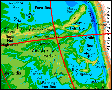
To the west, the south shore of the Peru Sea is open forest thinning inland to meadows and brush, though the heights of the Sala-Y-Gomez Mountains snag enough rain for tall pinewoods reminiscent of Nazca Peninsula. It's a hot but quite arable coast, densely settled.
Inland, to the south, the slopes of the Merriam Valley above its great chain of lakes are savanna and brush, dotted with trees at most; the Sala-Y-Gomez range blocks most storms off the Peru Sea. Though we're not that far south of Quebrada, it's another climatic world. Most folks here (of whatever species) fish the lakes and farm the shores or riverbottoms.
THE SENTINELS
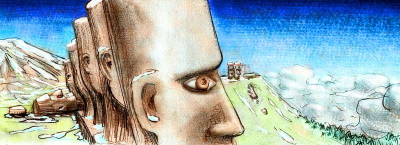
Sail up the north fork of the Merriam as far as you can, into the high lonely hills of Gallego and Rapa Nui. It's another patchwork of wood and meadow, deepening to forest on the western heights. This is hot monsoon country, half the year dry, half wet. Farms either parch or flood here; fishers and hunter-gatherers do better. And miners in the hills. Oh, and innkeepers. I know it seems unlikely that travelers would flock here, but they do. Two great peaks of the Sala-y-Gomez Range pierce the clouds in both seasons: Mt Sala, and Mt Pascua, the region's high point at 4450 meters (14,600', comparable to Mt Whitney or the Matterhorn). It's Pascua they come to see. It's hard work climbing it to find out why, but worth it. Even the new avian peoples of the Deeps generally do climb the last few miles, not fly; the air's uncomfortably thin for them.
But maybe they walk out of awe. Pascua's an eerie place: its grassy, windswept summit-plateau is guarded by hundreds of ancient, pitted, monstrous stone sentries, all gazing outwards at the lowlands, as if Pascua's a sanctuary of Old Earth on guard against the mutant life of Siphonia's Deeps. After ninety thousand years, most of their ranks have toppled (their Polynesian builders never expected frost-heaving!), but enough still stand to make the great mountain as holy as Fuji, though in many it inspires as much dread as awe. These long, strange, solemn faces are, after all, as old as twenty Sphinxes.
On the other hand, remember that in 90,000 years, a lot of creatures have adapted to the abyssal heat. They like it. And this is the Deep, with air supporting at least three species of intelligent fliers. It's not a preindustrial human farmbelt--isolation, ignorance, poor transport and communication. Flight changes all.
Even by human standards, the east coast is pleasant. Open woods and brushy hills, it looks quite Californian, though hotter of course. It's punctuated by more cool highlands like Nazca Peninsula, though these are smaller. The most scenic are rugged Cape Merriam and the Felix Range, facing each other across Felix Bay.
In the southeast, round the shores of Selkirk Sound, this maritime strip grows, invading the dry west. The map doesn't quite match the orbital photos here, due to new more accurate data. The coastline here (both globe and maps) will eventually have to be revised again to reflect the much more complex topography hidden on most seafloor maps by its relatively gentle slopes. Well, not ALL gentle--volcanic Mt Robinson on Cape Crusoe leaps 4400 meters (14,400') straight from the sea, taller than Fuji and actually snowy most winters. Climb it in high summer, and from its windy, grassy summit you'll spot a great white cone to the west: Mt Alejandro, rearing 5650 m (18,500'; as tall, head to toe, as Denali; taller than Kilimanjaro). It's the only glaciated peak west of the Andes.
These two giants crown a whole chain of volcanoes, and it's just a minor hot spot--the real tectonic action is to the west, where a live rift zone slants down through the Valdivia Hills--a branch of the Albatross Range. This spur, Cape Crusoe and Cape Gifford are clear enough, but the low-altitude relief is gentle, so it's harder to determine coastlines and islands than it is along, say, the brutal slash of the Andes--from ice peaks to trench in a few miles! So these capes and bays aren't final--half guesswork. I have tried.
Speaking of uncertainty, the "brutal slash of the Andes" trench has one very uncertain feature, depending on the interest, will, and technology of the Nazcans--and their neighbors to the south, in the Mornington Sea basin. At the southern tip of the Nazca Sea, the Andes Trench falters; one stretch is so shallow it's a mere valley, actually above sea level (if only just). It leads to the Mornington Sea about 100 km to the south. The Fernandez River winds along its floor much of the way. It wouldn't take much, no more than 20 km of canal, to link the Fernandez to the Taitao River to the south, linking these two large seas, at least for boats with shallow draft. Such boats could also reach the Scotia Deep to the southwest via Drake Channel (another stretch of the trench), and possibly Lake Panama in the far north. This navigable trade basin, though artificial, would rival some of Siphonia's natural oceans, and reach from the equator to the edge of Antarctica.
The preindustrial Greeks and Chinese managed to dig long canals; why not the Nazcans? Conditions here shouldn't be too difficult--it's no Suez Desert or malarial Panamanian jungle. So it does seem likely that the Fernandez Canal would eventually be dug. If the locals are motivated. Will they? If most are avians, or gliding or flying mammals--as seems possible in the Deeps--they may disdain such slow, dull voyaging. At least until they want to trade goods in bulk! On the other hand, humans, Amazonian otters and other large terrestrial peoples will most likely be common in the cooler Mornington basin, and they'll be motivated to dig a canal even if the northern parrots and gliderwolves just ride the thermals above them, laughing at the silly groundhogs...
THE WANNABE CONTINENT OF AGASSIZ
To the west, over the crest, the land drops in a long slope to the Agassiz Ocean--not just back to sea level but a full kilometer below! The climates of these far slopes diverge more than the shores of the Bauer and Mendana Seas. The northern area, the Gallego Hills, are close enough to the equator to get tropical storms off the Agassiz Sea; but in eastern Rapa Nui, the woods dry and thin as the land drops. Rain here is scarce and evaporation high.
Elsewhere in the Pacific Basin this dense air supports equally dense rainforest; but here the prevailing winds come from Nazca, and they've had the rain squeezed out by the Albatross Mts--Easter Island is a lonely speck on our maps, but it's just the highest peak of this massive range laid bare on Siphonia. So just off the map there may be great deserts, though strange ones--with constant, even heat and strangely mild sun, barely able to raise a tan, let alone burn you!
Any sensible geographer would spend much more time on this region between the Agassiz Ocean and the Nazca and Mornington Sea. By our standards, this huge stretch of land is continental--comparable to Africa in size and geography. Green coasts, dry interior, with deserts north and south bracketing a rainforest strip, and in the east, mountains generated by an exposed rift zone... the parallels are quite substantial. Call it Agassiz (ah-ga-SEE. Early geologist. Advocate of deep time.)
This near-continent of Agassiz richly deserves its own page, but it doesn't get one. For sound reasons: as I compared rival maps, I found they conflicted more than elsewhere, and were smaller and less detailed than such a big area deserves. Even large atlases of the sea skimped on it. It's the worst-mapped region on Earth, except perhaps for Antarctica! There's no mystery why it's neglected--there's not a speck of land south of Easter and Pitcairn Islands, and very few reefs and seamounts. Nowhere to settle, farm, mine or drill. No profit to be made, so no profit in mapping it closely! We may play at scientific objectivity, but in the end we're land animals. With land-biases.
I will try to describe its west shore, down by the (imaginatively named) Agassiz Ocean. But the vast dry interior... these generalities are about all I can tell you. Sorry. "Darkest Agassiz!"
In contrast, as you'll soon see, Mexican and American oceanographers have a much more detailed picture of the sea floor in...
THE NORTH: PANAMA
On the equator, the Carnegie Range rises as high as 5750 m (19,000') at its west end, the former Galapagos Islands. Notice that these huge peaks are snowless on the map and orbital photos; that's not an error. Though only a handful of Earth mountains are this tall head-to-foot, the Galapagos Peaks rise from a deeper, warmer basin than any on Earth; and they straddle the equator; the climatic equivalent of perhaps 3700 m (12,100') on Earth's equator. Cool, but not quite cold enough for white stuff.
The Carnegie Range dams a broad basin just to the north: Lake Panama is freshwater and lies at least a kilometer (and perhaps a full mile, over 1500 m) above the Peru Sea. Malpelo Island in its center is the largest freshwater island in the world. The region is geologically tormented, with curving, jagged ridges and "fjords" along the coasts and volcanoes in the highlands.
Travelers heading for the Atlantic Deep or points east all sail up the Panama River at the head of the Peru sea, up to the lake. Can ships of any size sail up the river? A kilometer (worse yet, a mile) is a lot of climb in just a few hundred kilometers; are there cataracts as on the Nile? It's hard to know; this is a shallow "ford" in a subduction trench, and in our world they're all deep-drowned, ooze-smothered; hard to say what you'd find if a river along one washed a canyon down to rock. Let's assume, though, that Siphonia's lucky, and the currents, though vigorous, never become falls or impassible rapids. Certainly every ship owner in Greater Nazca hopes so; as you'll see, even if the Panama River is navigable, the Atlantic Passage isn't easy. Travelers with wings follow the river too, since the Panama Valley continues the long flyway along the slopes of the Andes. Then fliers and sailors alike sail up the east shore to the foot of Panama Pass, now around 3100 m up (just over 10,000'). Most proceed on foot or by rail if the technology's developed. The hardiest fliers may attempt the Pass on the wing, but it's pretty grueling.
Well. That took us a bit far east. But it makes a point; Panama, though no longer a canal, is still a vital trade route between hemispheres. New Panama City is 200 km further south now, down on the lakeshore, but it's still a busy port. And I'll bet Old City still exists; while the fliers of the Deeps find its thin air uncomfortable, humans will like it better if anything; mild, springlike weather year-round, like Earth's tropical highlands around 7000' (over 2000 m).
THE NORTH: GUATEMALA SEA
To the northwest, over the Cocos Range (up to two miles/3 km high), lies the Guatemala Sea. How much of this huge basin is flooded? I'm not sure. If it filled to the brim and drained through the narrow gap between the west end of the Colón Range and Albatross Ridge, it'd be 8-900 meters up (2700-3000'), nearly as high as Lake Panama; if so, it'd probably be freshwater too.
Still, you could argue plausibly for an even smaller, very briny lake filling only the deepest part of the basin, nearly level with the Nazca Sea. Such a lake would look like an upside-down hat, comprising only the long Middle American Trench (so deep it will be flooded in any sane scenario) and a shallow, island-dotted tongue between Tehuantepec Ridge and Guardian Seamount. It'd be less than a third the size of the sea I've shown. Take your pick!
Except for the wettest scenario, when it's a true lake, the Guatemala Sea will swell in the rainy season and shrink in the dry; expect wide, treeless saltflats and marshes around its southern bulge. Hmm. In our world the best parallels for this are Lake Chad in the Sahel (not nearly as big, but similar climate) and the flat northern shores of the Caspian Sea, though its biggest variations happen over decades not annually.
The Guatemala Sea itself may have uncertain boundaries, but its basin ends clearly and emphatically--Albatross Ridge is an abrupt, spectacular escarpment up to a mile high, knife-thin in its southern half, widening into wooded plateaus in the north. Truly strange country; nowhere else does the rift zone act quite like this.
To the west of this knifeblade are the complex ranges of Clarion and Clipperton and the lakes of Mathematician Basin--Lake Einstein and Lake Euclid are only two of a dozen or more, great blue and muddy green eyes in golden savanna basins. Africa transplanted! These are freshwater lakes feeding long rivers flowing west.
Downstream (on far left) trees spangle the veldt, more and more as we go lower and lower, into denser, more humid air, like nothing on Old Earth; raft the Clarion too far, and you'll end up gasping in the steamy monsoon forests around Clarion Bay--blood-warm even in the shade. This is otter, parrot and river-dolphin country; few humans can stand it.
We won't go further north, or down to the shore; that properly belongs to the Pacific Basin tour.
THE MANAGUA PASS
One afterthought; in our world, Panama is the only tropical route for quick hemispheric shipping; but on Siphonia, it only serves the Nazca Basin. Pacific traffic (and there's much more of it) sails east up the Colorado River, (a scenic but hot trip through the Clarion Desert), to its sharp bend north into the Vale of Cortez. Here at the port city of Elbow, travelers either portage or (if the terrain makes it possible and the traffic justifies the effort of building the Elbow Canal) sail in shallow-draft boats along the canal about 20 km to the Trench River and 100 km southeast to its delta at the head of the Guatemala Sea. Our pilgrims sail along its north shore to Nicaragua. Soon they must disembark; the stretch of river they follow has cascade after rapid.
Up to this point, fliers native to the Deep can manage comfortably, but the Managua Pass, while no higher than Panama, is much longer. Managua, not Panama, is the "canal" route! For hundreds of km, a quite navigable chain of rivers and lakes lead across a pleasant green plateau dotted with volcanoes--still snowless, despite the cooler conditions of Siphonia. Instead of a snowy giant every 1-200 km, as in parts of the Andes or the Cascades, dozens of lesser cones pepper the landscape. On Earth, a Nicaraguan Canal was nearly dug, and might have been less costly than Panama (in lives, too); politics not commonsense chose the hills of Panama over the flatter Nicaranguan route. But on Siphonia, both are equally viable--if vastly more difficult than either Terran route. For these passes are 3 to 3.5 km high (10-11,000'). Boats can sail these high-altitude lakes, but they can't climb to them or descend the far side.
So, east of huge Lake Nicaragua, you sail on down the San Juan River a couple of days, but then the navigable stretch ends; the stream drops through broken country (limestone mesas--reefs from Old Earth) down to Maiz Bay on Lake Carib, the freshwater, high-altitude remnant of the Caribbean Sea. From Port Maiz ships head for Lake Virgin and the Falls, just as Panamanian shipping does.
|
|
Siphonia's homepage - map - peoples of Siphonia - Siphonia's evolution - Gazetteer
LISTS AND LINKS: More worlds? Planetocopia! - dreams of other worlds - ecology - climate change - evolution - natural disasters - terraforming - sculptures and 3D art -
World Dream Bank homepage - Art gallery - New stuff - Introductory sampler, best dreams, best art - On dreamwork - Books
Indexes: Subject - Author - Date - Names - Places - Art media/styles
Titles: A - B - C - D - E - F - G - H - IJ - KL - M - NO - PQ - R - Sa-Sk - Sl-Sz - T - UV - WXYZ
Email: wdreamb@yahoo.com - Catalog of art, books, CDs - Behind the Curtain: FAQs, bio, site map - Kindred sites