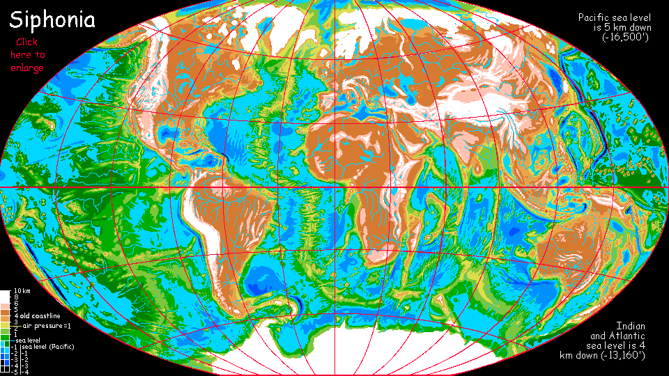
Siphonia:
Pacific Ocean
by Chris Wayan, 2006-9
Siphonia - map - regional tours - People, Creatures - Evolution - (don't click yet: Gazetteer - Glossary) - more worlds? Planetocopia!
INTRODUCTION
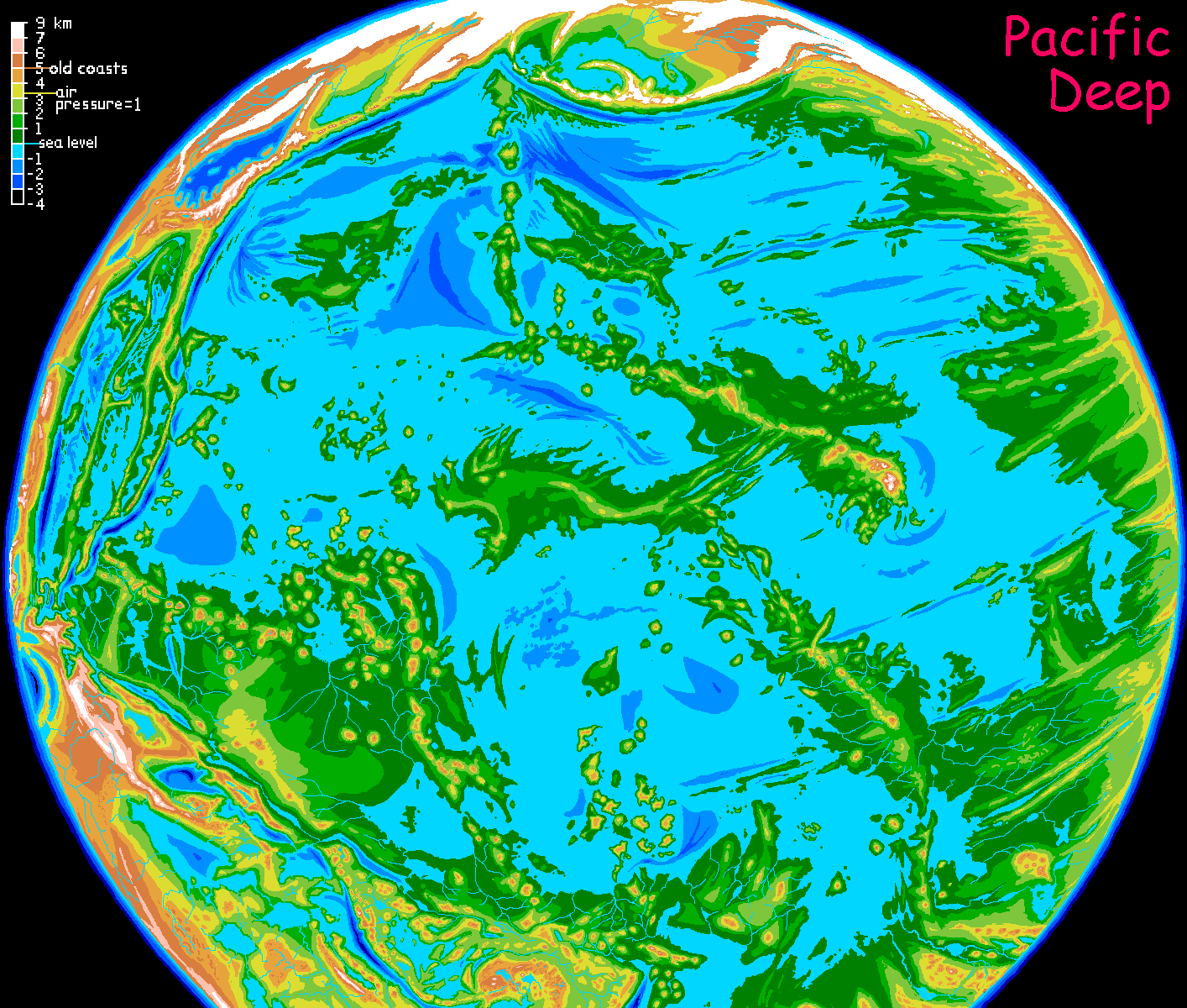
First, a warning. The title misleads most readers. Siphonia's "Pacific Ocean" fills less than half our Pacific basin. It's cut off by mountains around the Tropic of Capricorn; over narrow Cook Isthmus is a second ocean, the Agassiz, stretching from Tahiti to New Zealand. And around these two giants are a halo of shallower, higher remnant seas, many large enough to deserve separate pages/tours: Guatemala, Nazca, Mornington, Tasman, Fiji and Coral, Philippine, China, Japan, Kurile....and that's only the largest seas.
So this page only covers the largest remnant of the Pacific--one of many. With that in mind, let's look at this... puddle? Not at all! It still does earn the name of ocean; this shrunken Pacific is still the biggest and deepest ocean left on all Siphonia, not just our old Pacific basin.
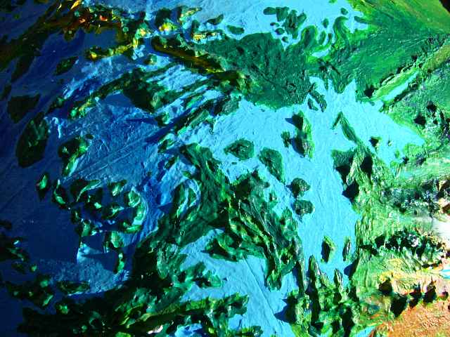
But on Siphonia, this violently vertical world is bared.
HAWAI'I
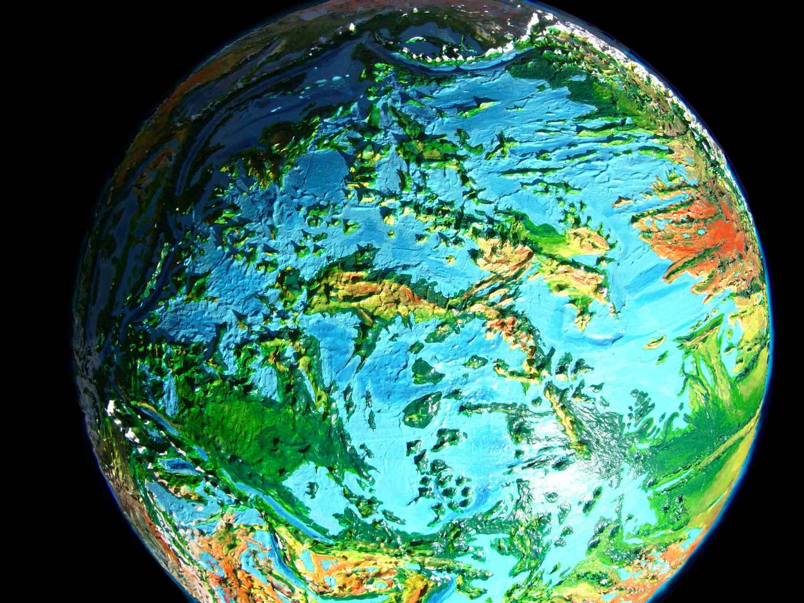
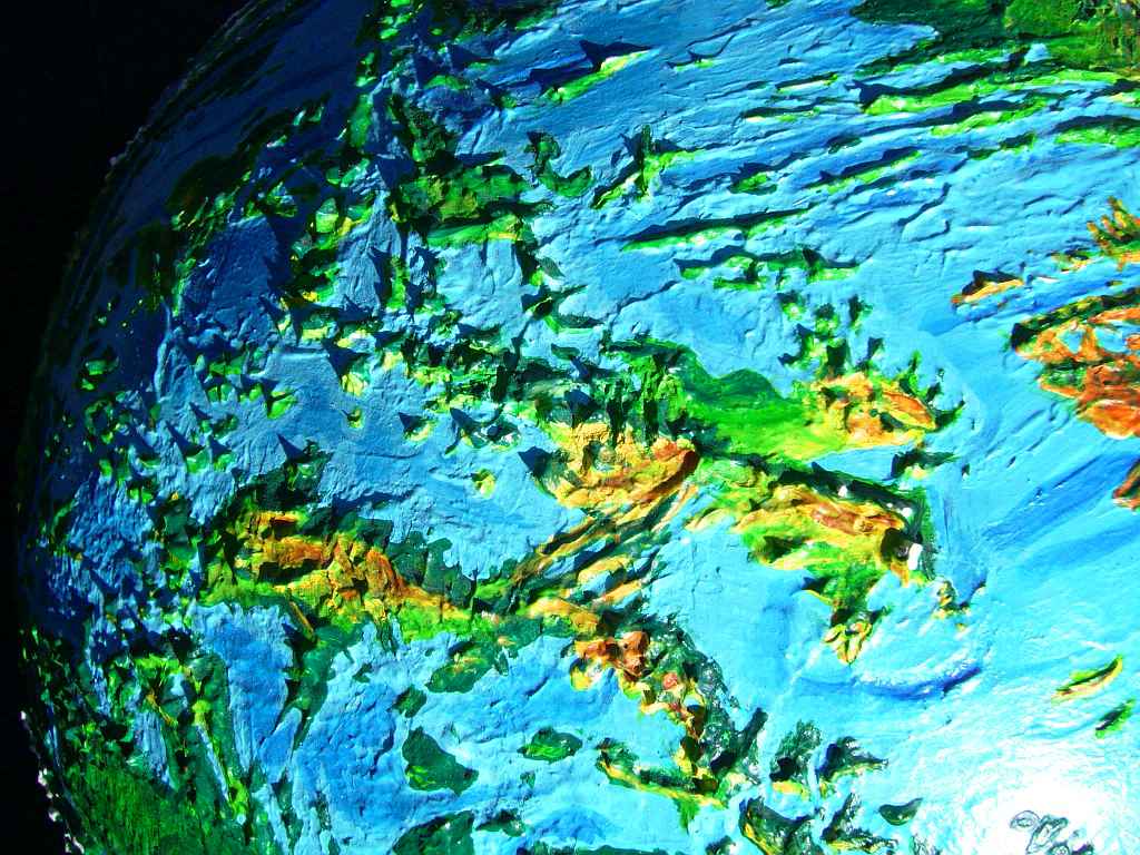
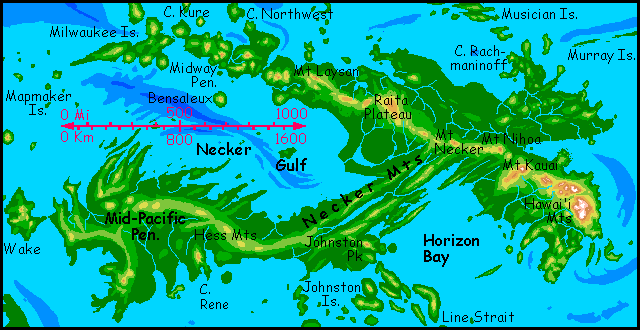
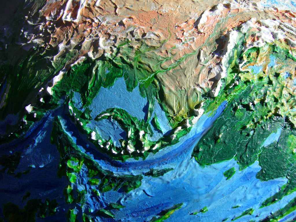
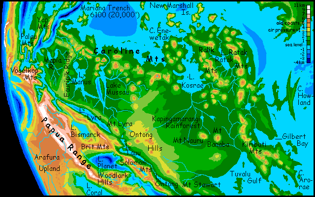
The most obvious feature in the Pacific is the small continent in the center: the continent of Hawai'i. The upper ridge is the Hawai'ian chain itself, with the glaciated island-peaks on the right; the lower, the Mid-Pacific Seamount Chain; linking the two great lobes is narrower Necker Ridge. To the north are lower but Japan-sized islands.
Hawai'i is probably the largest continent in the world. This seems unlikely, since it's only a few million square kilometers (between half and two-thirds as big as our Australia; it's hard to be exact). But Hawai'i must be the largest, since it's the only continent. You may scoff, given Siphonia's vast stretches of land, over twice the land-surface of Earth, but it's true--at least by the strict Terran meaning of "continent": a large landmass surrounded by sea. Nothing else is, anymore. All seas on Siphonia, large or small, are Caspians--big salty lakes. It's the land that's continuous. Spherical geometry make it debatable what "surrounded" means, to I suppose you could say there are two continents: Hawai'i, and everything else. Even so, that gives you some idea how unusual this deeply isolated volcanic chain is. Even in a world this transformed, it's a lonely exception.
But climatically, Hawai'i's peaks aren't nearly as savage as the Himalaya; due to high air pressure in the Pacific Basin, conditions 2800 m up (9000') are much like at our sea level, and alpine meadows can be found in sunny spots up to 7 km up (23,000').
The upper slopes of these shield volcanoes are relatively gentle, of course--Hawai'ians coined the phrase "shield volcano" and it's an apt description--but their exposed knees are much steeper, even cliffs in places. In fact, it almost makes one wonder if their huge Martian cousin, Mt Olympus, has such spectacular terminal cliffs for the same reason... Nah. Surely Mars never had seas that deep! But oceans do have a splendidly sobering effect on shield volcanoes: their lava can't sprawl drunkenly all over the place, as it can in air. Cold water's a fixative keeping them vertical. Like cold showers to a drunk...
The photos do reveal the general trend: the lowlands northeast of the Hawai'ian Range are rainforest; the southeast side is dry; the region south of Raita Plateau is a desert, though spangled with marshy lakes fed by rivers off the green highlands. The Necker Range and the far west are complex patchworks of jungle, open woods, savanna and desert, depending on orientation and altitude, just as in our Hawai'ian Islands; but I won't know details until the topography becomes clearer.
THE FAR NORTH PACIFIC
The big blue smile in the next orbital photo is the Aleutian Trench. The upper jaw with the white teeth is the Aleutian Range, former islands, now mountains taller than the Andes. Here Alaska lives on; while most of mainland Alaska is now ice or barrens, altitudes vary so much in the Aleutians that habitats for almost all Alaskan species can be found somewhere on the sunny southern or shady northern slopes. The lowlands on both sides of the Trench are very un-Alaskan indeed; the dense air of the Pacific Deep traps heat, making these coasts very warm and mild; snow is rare; more like coastal Oregon than Alaska most of the time. But in some winters, cold dry winds off the icy peaks above are a harsh reminder that you're on the border of another world.
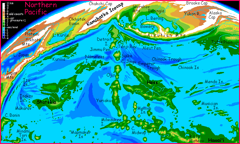
Lake Bering is nearly a mile higher than the Pacific Ocean (1.4 km up; still 3.5 km (11,500') below our sea level). Is Bering a salt sea, or a freshwater lake? It does have an outlet to the Pacific, west through a chain of lakes. But are the Yukon (upper right) and other rivers of Beringia enough to flush out the salt in 90,000 years? Probably. It's shallow, and the region is rainier than it is in our day, since the air is much denser and warmer; not as dense as that of the Pacific Basin proper, but still enough to keep Beringia mild for its latitude.
The mountain-arc curving north then west from the Aleutians, in the center of Beringia, is the Bowers Range, 3.5 km high (11,500'). The straight range to the northwest, creating a sill the Bering Sea must flow over on its way to the Pacific, is the Shirshov Range. This north-south ridge is just a finger of the stark highlands of Old Beringia.
Climb the slopes to the north, and you soon leave the forest. Here is Ice Age Beringia: cold tundra with (at most) willows and berry-brambles in sheltered river valleys. Keep going, and you'll regret it. The air grows thin, the weather harsh, until the growing season is just too short to support even grass. The barren plain is almost cold enough to sustain an ice sheet--it does, on the St. Lawrence Hills ahead. Veer right, around their rolling icy-domes, and another line of deadly white gleams ahead. The Northern Ice is back. But there is a gap of sorts, if you time your trip right: Bering Pass. Snowy most of the year, freezing mud the rest.
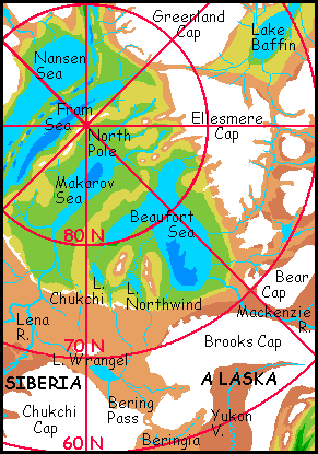
If you're crazy enough to push on through the Pass into the High Arctic, trekking steadily north, you'll be shocked: a great cliff, north-facing, shadowed, pocketed with perpetual ice, drops into livable lowlands again! Northwind Valley, 3 km deep, is part of the basin of the now-shrunken Beaufort Sea. And it's not alone. A chain of sunken seas with cool but not frozen shores crosses the Arctic! Arctic spruce grow near the Pole itself. It's amazing what 90,000 years of evaporation can do... but that's another page.
THE PACIFIC NORTHEAST
The Pacific basin east of Hawai'i is relatively flat, but broken by long straight ridges and canyons. Desert canyons. If the American West of the cowboys is now alpine or iced over, it's been more than replaced: the Clarion Desert is one of the biggest in the world, and resembles its ancestor upstream, in life-forms and variety. This region of the Pacific hid many seamounts nearing the surface, sheared off by erosion during the Ice Age. Now they're mountains up to 4800 m (16,000') high.
Because Siphonia's Pacific Basin has much denser air than Earth, the region is warmer than its latitudes suggest. Wide Tufts Plain has a subtropical climate--northern California, Oregon, southern France? Long Kodiak Sound, and the plains below the Aleutian Range (cold to subarctic on Earth) are cooler but still rarely see snow. Northern peaks above 4 km high, such as Mt Surveyor, Mt Patton and the Juan de Fuca Range get heavy winter snowpacks, as do giants like Guadalupe even in the hot south. But overall, this region is more Mediterranean than like the old Pacific Northwest. It may be Siphonia's new Europe; similar climate, at least. Europe sure isn't Europe any more...
The lower Columbia and Fraser valleys are warm, and even their middle stretches, 2-3 km up, are warm-temperate. Indeed, here the livable zone reaches all the way up onto the old continent itself; Oregon's Willamette Valley, and the former Puget Sound are Scandinavian, with long cold winters, but still wooded and fertile.
I'm still discovering things about this region, but here's a sketchmap. Click for a closer look.
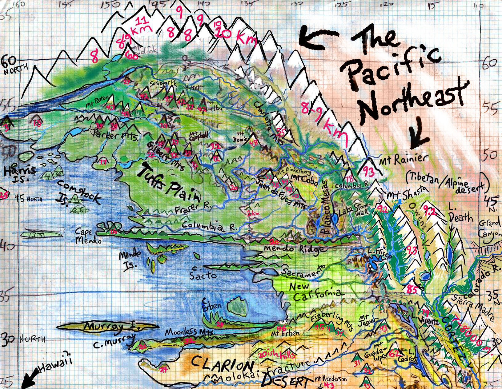
EAST PACIFIC CANYONS
South over long Mendo Ridge, the land grows even warmer and drier. The Sacramento River plain is more like Southern than Northern California--semiarid though mild as deserts go, and quite Mediterranean along the coast. Upriver is hot savanna, dotted with oaks; then the pine-clad wall of the snowy California Mts (we certainly can't call them the Coast Range). The main fork of the Sacramento climbs to the shores of cool Lake Frisco (don't take the south fork--if you try to climb up the Pajaro River, you'll end up in Monterey Canyon--walls two miles high! Spectacular but hell to climb up). Past Lake Frisco's upstream marshes, the Great Valley opens up, entirely surrounded by mountains of Himalayan height. This cool, fertile, forested valley some 500 miles long has a climate like Germany, snowy in the winter but with pleasant summers.
And there are other Pacific Rim surprises. Consider low deserts like Death Valley--on Earth, a searing trench below sea level. Now it's a cool, lake-filled grassy valley around Lake Death, below the spectacular glaciated horns of the Panamint Range, 3400 meters straight up...
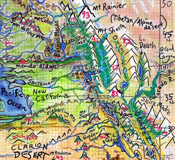
And the Grand Canyon, now snowy to the bottom in winter and getting more overall precipitation than it did in its Earthly days--every side gallery has living streams and falls down to its subalpine meadows and groves. The North Rim is icecapped, the south, alpine barrens; but the canyon between, cool but livable, is a refuge for hundreds of species. Further south, in northern Mexico, Copper Canyon is much the same.
But these are all just branches of a greater canyon Terrans might overlook. We call it the Sea of Cortez. Now it's a rift-valley 1000 miles long--Death Valley's just its little finger. As the floor descends below the old sea level, the subalpine meadows and cool forests give way to open woods, prairie and high desert--chaparral and piñon. Lower still, Joshua trees have found a new home... The Colorado River floodplain and its many side branches are well-settled with refugees from the former Southwest, who grow maize, chilis, beans and squash in the rich soil of the riverbends... as they have for 100,000 years. Classic recipes travel well.
West and south of the ruins of old Los Angeles (not that there really are any; a flimsy town. Stucco doesn't last, and the cool pine forests covering LA and the San Fernando Valley cover up the few recognizable heaps of rubble) are the subalpine Catalina Lakes, below the Channel Mountains. These drain south into Lake Vicente. The east shore of Vicente, and still larger Lake Cedros to the south are scarps and sheer cliffs up to a kilometer high. Snowfed waterfalls fray into mist before they reach the lake. It's reminiscent of old Yosemite, now a near-treeless alpine canyon snowed in most of the year. The cause, of course, is utterly unlike Yosemite's icy birth: the Cedros Scarp is the work of yet another spur of the San Andreas Fault.
I don't mean to hover on one area, I just grew up in this region. Pardon my localism! We'll continue south now. Be sure you packed extra water: over the Fieberling Range, you drop into true desert, one of the world's largest: the Clarion.
THE CLARION DESERT
Though dry, Clarion's climate is gentler than Earth's great deserts. The high air pressure blocks ultraviolet, smooths temperature swings, and holds moisture, so wherever mountains and ridges rise enough to cool the winds, rain feeds "sky islands" of grass and pine. Not much winter snow, though, except on the tallest peaks like Clarion, Revillagigedo, Cedros and Guadalupe; it's too hot.
Runoff from these plateaus collects into long straight rivers following great east-west fractures like Molokai Ridge and the Suitcase Mountains. These rivers often pool into spindle-shaped lakes up to a few hundred km long; like unsnarled St. Lawrences, these silty streams are often more Lake than River. Though streams like the Molokai and Henderson and Guadalupe mostly cross low desert, their flows are substantial and perennial, never failing in summer; for their headwaters are glaciers far to the east, in the huge icefields of the Sierras and Rockies and Bajas.
 The greatest of these stretched rivers is the lower Colorado. On Earth the stream rarely even reaches the sea; on Siphonia it's reborn as a muscular snowfed river thick with glacial silt, running some 7500 km (4500 mi, longer than any river on Old Earth) down from the Tibetan highlands of Four Corners, between the ice-capped walls of the Grand Canyon (like a knife through carrotcake with vanilla frosting), then south along the old Sea of Cortez, now a thousand-mile valley where the former natives of Northern Mexico farm and ranch. At last, below the ski resorts of Mazatlan (just kidding) and Guadalajara (no, really) high on the canyon rim, the great river turns west through the desert, on its long way to the sea; a lateral Nile where farmers grow citrus, watermelon, okra, cactus fruit...
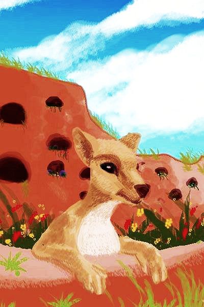
It's so hot and the air's so dense that most of these farmers aren't human, but a new species: gliderwolves. These small, lanky, amiable, intelligent canines nest in cliff-burrows and glide down to their garden on skin-flaps like great flying squirrels, catching thermals and updrafts to climb back home. Even they must siesta through the heat, which can rival Iraq's. (Old Iraq, I mean; today of course, Iraq's a plateau with warm but not scorching summers and gets a dusting of winter snow...)
There's a major riverport at this Colorado bend, called Elbow for obvious reasons. An interesting place and curiously cosmopolitan for a desert town, full of a mixture of humans and newer intelligent species--megaravens, dwarf gracile elephants, Amazonian otters, big-brained apes, a few gliderwolves (not many; Elbow is a high-altitude city for them, like Lhasa or Cuzco for humans; they find it hard to fly in less than 1.4 atmospheres, and Elbow's 1.2; upriver it thins quickly to 1 or less) and even the occasional (and probably heat-stroked) llama.
Geography forced this diversity: Elbow caters to travelers between hemispheres, for this is the easiest route between Atlantic and Pacific. I've described this grueling passage fully in the Nazca Sea section, but here's the short version...
Shallow-draft riverboats sail up the Colorado to Elbow, then follow a canal about ten miles to the headwaters of the short Trench River, running down to the Guatemala Sea. A thousand km down the shore, boats head up the Nicaragua River, though they can't get far; the river climbs 3500 m (c. 11,000') to Managua Pass. On foot or via caravan, then, travelers trudge over the American spine (I'm oversimplifying; in the middle there's a three-day boat ride over Lake Nicaragua) and down to Lake Carib. Embarking again, they spend days beating east across this huge freshwater sea. At Virgin Cascade they again take to the land, hiking or riding the muddy switchbacks down through cloudforest into sweltering jungle; for the Virgin tumbles over a dozen Niagaras as it rushes down to the Atlantic Deep.
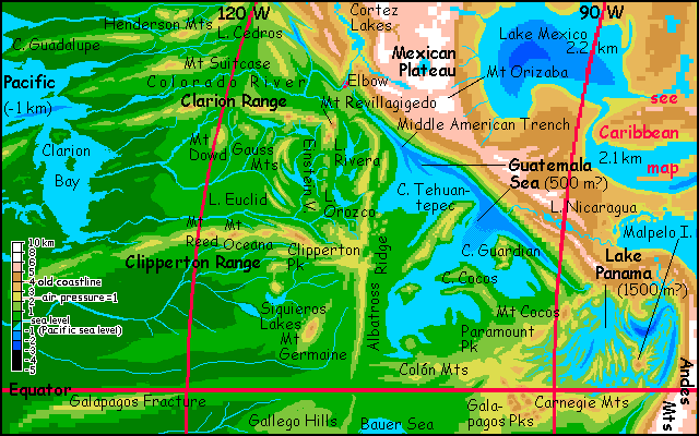
The desert ends abruptly south of the Colorado River. Here rises the Clarion Range, alpine in height if not climate; we're so far enough to the south now that even these rugged mountains rarely see much snow.
To the south lies Clippertonia, an equatorial rainforest hotter and rainier than West Africa.
THE SOUTH PACIFIC
South as in equatorial--remember, there's a whole separate ocean south of the Tropic of Capricorn, the Agassiz Ocean, and even that doesn't reach Antarctica; that's a third sea, the Mornington. On Siphonia, "South Pacific" means a long convoluted equatorial coast, hotter and more humid than Amazonia due to its dense air. Huge rainforests, with feathery, buttressed trees adapted to a hurricane a week and ten meters or more of annual rain.
Polynesia? Well... it's still there. But it's not what you think.
Center-right is Filippo Bay, center-left is the Penrhyn Sea, the southernmost lobe of the Pacific; the southwestern Pacific is in shadow, past deep green Manihiki Plateau.
In the next shot, a bit further northwest, the narrow strait called Line Gap, leading north to Hawai'i, is just visible at top. Just south of it is huge green Cape Kiritimati ("Christmas"), whose muggy, rainforested coasts might as well be an alien planet. Almost no humans live here; too hot. Only abyssal natives need apply...
The lower deep-green peninsula is Manihiki, a hilly jungle-smothered land the size of Borneo; its uplands are cooler than Kiritimati, being merely torrid. Indonesian and Amazonian species do well here, including some humans. East of Manihiki (right) is the Penrhyn Sea; to the left, still partly in shadow, the Magellan Sea, hot as a bath: a perfect typhoon generator.
In the lower left, in low dawn light, you can see the strange rugged knot of the Phoenix Islands, a cluster of volcanoes three miles high, rearing from the sea, clad in dense jungle almost head to toe, opening to meadows only on their summit-plateaus--the ancient reefs, lagoons and islands of our Phoenixes. Far greener than our Galapagos, it's more like Conan Doyle's The Lost World--times seven. What a perfect laboratory for speciation! Seven Petri dishes in the sky. Who knows what'll evolve here? Some new Darwin is going to have fun.
THE PACIFIC SOUTHWEST
The southwestern Pacific basin contains the largest stretch of bottomland on Siphonia. Not far past Hawai'i and Wake lies a great plain the size of the Amazon, dotted with volcanoes and lakes: Kapingamarangi Rainforest. Hotter and rainier than Amazonia--really, there's no dry season at all. Biomass is the densest on the planet; it looks like the Mesozoic, though dino analogues won't be stomping through the understory in a mere 90,000 years. But there will be large beasties in these jungles; gracile elephants, for one, tall and rangy for heat dispersal. Many creatures that weren't arboreal on Earth have headed into the canopy, 100 meters up. In the dense air, many mammals have grown skinflaps letting them glide. Birds have grown; the maximum flight-weight is at least 25-30 kg (about 60 lbs). See Life in the Pacific below.
THE WESTERN PACIFIC
Due west of Hawai'i is a new Polynesia far larger than the old! Geologically, these far-scattered isles are much like the south's Phoenix Islands--steep volcanic sky-mesas capped with strange windy savanna-plateaus above the clouds. Haunted heights. Their climate? Haven't got one. Microclimates, like Hawai'i: jungle on the northeast scarps, desert on the southeast, sunny but green between. Don't like the climate? Move ten miles!
The largest by far is Wake, nearly as big as Ireland; to the north, west and southwest are the Mapmaker, Marcus, Minami Tori, Magellan and Marshall chains. A hundred Hawai'is! Why they all begin with M is beyond me.
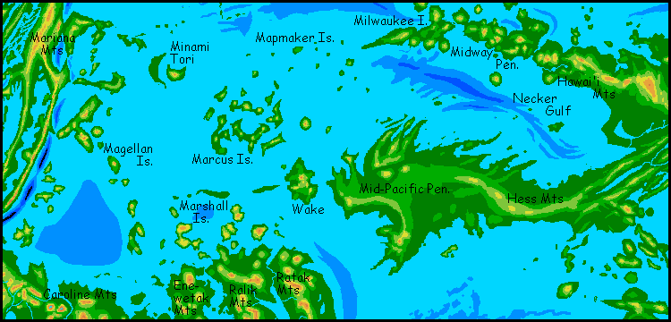
This emerald-scatter stretches a couple of thousand km west, then ends suddenly in deep trenches and the great mountain wall of the Mariana Range (merely alpine) and Japan, as high as our Himalaya. Fuji rivals Mauna Kea as the tallest peak in the world...
THE PACIFIC NORTHWEST
Apology time! I simply haven't finished painting the west, so I've got no photos to show you yet. Sorry. Blame regional prejudice! Well, life experience. I grew up in the Pacific Northeast, and haven't been west of Hawaii; hence I've been more tentative in the west. I simply know the east better.
So all I have for the northwest Pacific is a preliminary altitude map. The Emperor Seamount chain, the long trail left by Hawaii's hotspot, has become a great archipelago as big as our Indonesia--and not that much cooler in the south. Even Detroit Island in the far north (not far from our world's Kamchatka and the Aleutian Islands, home of the foulest weather on Earth) has warm summers and mild winters--snow on the Detroit Plateau but not on the coasts. That dense air again.
The largest of these islands--Hess, Shatskia, and Detroit--each rival our Madagascar; together the North Pacific islands total 2-3 million square kilometers (1M sq mi).
Sorry about Nameless Island. It truly is, though; haven't seen a name for that region of the sea floor in any atlas. Just part of the Shatskiy Rise... Oh well, my favorite sushi place here in San Francisco, on Church Street, was called the No-Name, since it lacked a sign. It just folded; let Nameless Island be its tombstone. There will, after all, be excellent sushi there; its convoluted, almost fractal coast implies hundreds of sheltered sounds. Every village is maritime! The No-Names will be fishers rivaling the Japanese. Living on a land with no interior, what else can they do?
And despite its name, Detroit Island is much the same--at least the Aleut and Jimmu peninsulas. Detroit Tableland in the northwest is quite different: a cool wooded plateau at least a mile up--so cool it actually may see winter snow, as do the (much higher) peaks of Suiko, Ojin, and Yuriaku--these three essentially form a new Japan, warmer along the coasts and with higher mountains.
Hess and Shatskia are very different: low, chunky, near-continental islands, both bowl-shaped, with rim-ranges cutting off the interior. These inland lake-basins are drier and opener than the rainy coasts, particularly western Shatskia, a broad land of low prairies and ridges with Mediterranean groves and brush.
CLIMATE OF THE PACIFIC
The Pacific lies a kilometer below the other oceans, and air pressure is over 1.7 atmospheres. Heated by its dense air, the basin is steamy; the southern shore is about the hottest place on Siphonia. Even the northern edge, below the snowy Aleutian Mountains, is mild, but on the equator, the mean noon temperature is 40 C (104 F) and can range up past 50 (122).
Did I mention the humidity is close to 100%? This isn't Iraq or Death Valley. It's a steambath. Siesta City. Nobody works all afternoon. Not just nap time, bath time! Pre-Slurp creatures go swimming--or else they slow-cook.
We'd find it an alien world--lush, beautiful, but unfriendly. All that hot air rising creates huge storms. Summer especially sees back-to-back hurricanes--rarely over 160 kph (100 mph), but the dense air gives that a double punch. Huge rainforests cover these shores, but every trunk is buttressed and every leaf is lace.
Animal life mostly flies or at least glides--not just birds but mammals and reptiles too. It's just so much easier when the air's that thick; smaller wings can support an animal's weight, and the maximum practical flight-weight is 25-30 kg (about 60 lbs), not 15 / 35 as on Earth. That has consequences for intelligent life...
LIFE IN THE PACIFIC
The Pacific is one of only two seas fully 5 km below the old sea level. Beside trapping heat, the high air pressure makes flight easy. Even large animals glide on skin flaps from tree to tree, and many fly.
Including the people. No, not humans. In the south at least, it's too hot for them: often 50 C (122 F) and 100% humidity! The dominant species here will be giant parrots. Even our parrots are as bright as chimps, though it took until this decade for the evidence to finally overcome mammalian scientific prejudices. And they manage it with brains weighing only ounces. Bird brains (despite human insults) beat mammal brains for efficiency--by a wide margin!
But the dense air of the Pacific Deep supports much bigger fliers. Most parrots are no more than 10 kg, but that's quite large enough for them to have brainweights of 5-600 grams--well over a pound. They're just as intelligent as a human--smarter, if you ask them. These megaparrots are imposing creatures in other ways as well: brilliantly colored, with much deeper (but still piercing) voices, and wingspans up to 4 meters (13').
Equally imposing are their distant cousins: megaravens. They're even less recognizable, for in these hot basins, black feathers were a sun-absorbing disadvantage; as they grew, they lightened in color, ending up looking more like their close cousins the jays: various mixtures of gray, blue and white. But they're unmistakable: huge heads, rich but hoarse voices, the playfulness tinged with a dark irony... really, they haven't changed a bit. A useful tonic to anyone grown tired of parrots' loud good cheer (punctuated by equally loud prima-donna tantrums).
But fliers aren't the only creatures who have grown larger, with startling consequences for brain size. For an example I'll use the species you're most likely to meet here in the Pacific: a newly evolved people who cope with the heat and humidity in a different way, by hardly coming out of the water, in the day at least. You see them in every port and river town: big wet furry things chirping at you and wiggling their whiskers. They're descendants of giant freshwater Amazonian otters, of course.

Their quick evolution was one of those unpredictable consequences of radical environmental change. Recent studies show that the size of animals and the number of species (and probably total biomass, too) correlate well with the oxygen content of the air. Earth's atmosphere has varied greatly over its history--in the last billion years alone, it's ranged from 13 to 30% oxygen! While the percentage of oxygen on Siphonia isn't much higher than on our Earth, the many dense rainforests in the deepest basins like Agassiz have pushed it higher, to about 22%--one tenth more than on Earth.
Sound biologically trivial? But that's just the percentage. Down in these deep high-pressure basins, available oxygen is about 185% of Earth's--a bigger change than animal life has seen since brains evolved! All that extra oxygen makes it much easier for an animal to grow larger--OR to maintain large specialized, oxygen-hungry organs. Like brains! They're the costliest organ of all, pound for pound--hogging both calories and oxygen. In an environment where food isn't too hard to get--and these lush coasts qualify--it turns out that supercharged air has freed many nonflying species to grow much larger and more intelligent.
Amazonian otters, already big and bright, apparently crossed a crucial threshhold: social intelligence, the ability to understand, predict, and influence other creatures' behavior, became more important as they got less predictable. A spiral of brain-growth ensued, rather quickly tripling brain-size... just as it had in humans and dolphins.
Other than scaling up, otters haven't changed much, physically. The main adaptation is to heat: they're gracile, that is, slenderer, with longer limbs. More surface area per pound means a cooler otter: more evaporative heat dispersal when they're on land--or in bloodwarm water.
While human intervention was essential in their appearance here, humans didn't breed or genetically engineer them--they just built the wagons (or railroads) that carried otters seeking dockside and fishing jobs (or just curious types, intrigued by tales of the Pacific Deep) across the Pagatonian Steppes, or over Orkney Pass near Antarctica, or via the Managua and Colorado Canals, or over Macquarie Pass south of New Zealand, or over Marion Pass and through the labyrinthine Anzac Lakes (the simplest five ways to cross into the Pacific--none of them easy). Their descendants naturalized, and are found all over the warmer parts of the Pacific and Agassiz basins. Originally tropical, these otters are adaptable; some are now found along the Aleutian coast, and even the Bering Sea above 50 north. It's much warmer than our world would be, of course--air that dense guarantees it never snows, not at 50, and rarely at 60--but they've come a long way from muddy tributaries of the equatorial Amazon.
Of course, mentally they've come further still; from animals to people in a geological blink.
And their immigrants' tales could be echoed by orangutans and other great apes. Though the arctic wolves who spread south and were shaped by abyssal conditions into much smaller, lighter, smarter gliderwolves... they did it all on their own, as did the gracile elephants, the giant parrots, the ravens...
|
|
Siphonia's homepage - map - peoples of Siphonia - Siphonia's evolution - Gazetteer
LISTS AND LINKS: More worlds? Planetocopia! - dreams of other worlds - ecology - climate change - evolution - natural disasters - terraforming - sculptures and 3D art -
World Dream Bank homepage - Art gallery - New stuff - Introductory sampler, best dreams, best art - On dreamwork - Books
Indexes: Subject - Author - Date - Names - Places - Art media/styles
Titles: A - B - C - D - E - F - G - H - IJ - KL - M - NO - PQ - R - Sa-Sk - Sl-Sz - T - UV - WXYZ
Email: wdreamb@yahoo.com - Catalog of art, books, CDs - Behind the Curtain: FAQs, bio, site map - Kindred sites