WELCOME TO TURNOVIA
An upside-down world:
one of a series of alternate worlds created by tilting Earth's axis,
exploring climatology, evolution, and cultural geography
by Chris Wayan, 2003

WELCOME TO TURNOVIA
An upside-down world:
one of a series of alternate worlds created by tilting Earth's axis,
exploring climatology, evolution, and cultural geography
by Chris Wayan, 2003
GLOBAL CLIMATE AND SEA LEVEL
After building a hothouse Earth, and an Earth locked in a permanent Ice Age, I wanted something easier--closer to home. So I picked a smaller change: what would Earth be like upside down? We've all seen maps with north and south exchanged, but these are mere mental exercises in anti-colonialism. Turnovia is the real thing. With Earth's poles flipped, it has backward currents, winds and rainfall patterns. Deserts and jungles and icefields shift, and species, including our own, flourish in different places.
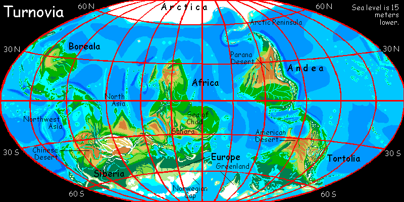
Is the situation stable? I doubt it--ours isn't. But Turnovia's ice ages will freeze Europe before Canada, and its interglacials will thaw Canada first. Greenland remains the most polar landmass, yet if the Spanish Current is not disrupted, Greenland may well thaw out entirely, at times--except for the tall mountains on its west coast. Their icefields are a perpetual seed for the next glaciation--assuming Turnovian climate fluctuates. Though with these twin seedling ice-sheets melting and advancing, I'd bet Turnovia's even less stable than Earth. I arbitrarily chose to show a state comparable to our own interglacial.
A TOUR OF TURNOVIA
I've processed these orbital photos very little. Names and boundaries and meridians are not marked; only the text will guide you. I have made a few concessions: I've stripped away clouds so the landforms are clear, roughly indicated water depth by color, shown both polar icepacks near summer minimum (unlikely to happen simultaneously!), but shown mountain snowpacks more generously to highlight them, and marked live volcanoes in red.
EUROPE
AFRICA AND ARABIA
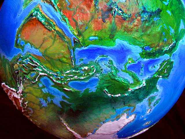
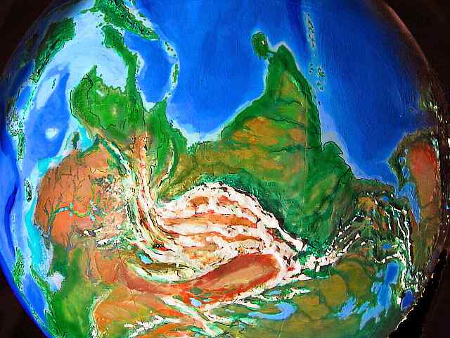
Morocco's Atlas Mountains sport glaciers, and the coast below is densely forested. Huge lakes cover parts of Senegal and Mauretania, whose humid coasts resemble Florida or Vietnam. The Sahara is one of the world's great fertile zones, densely wooded near the coasts, open woods inland, with savanna in the southwest around the Sea of Chad. The central Saharan ranges of Jebel Marra, Tibesti, and Ahaggar are pine-clad, snowy in winter, and the source of dozens of rivers breaking up the modest deserts of Egypt, Libya, and southern Sudan.
The ranges around Lake Malawi also catch enough rain to hem in the desert. Tanzania, the Great Lakes region, and Ethiopia are wetter than our world; these complex uplands are a patchwork of woods and prairies, with only a few small rainshadows. The Ogaden Desert is gone too: Somalia and most of Kenya are rainforest (as they were in our world's recent past). Only the lowlands of the Afar Triangle and the Red Sea are still dry, since high mountains cut them off from the sea. Still, the mountains of Yemen, Sudan, and even Arabia and Oman are quite green, and the lowlands are more Sahel than Sahara. Large lakes (instead of salt pans) make Oman's flats a wildlife oasis. The Empty Quarter is Arizona-like, with occasional streams, and the rest of Arabia ranges from arid to prairie and savanna. The Tigris and Euphrates are not alone; half a dozen rivers wind across the lowlands, from Damascus, Petra, even Mecca, each an oasis for huge herds that graze the plains. It looks more like the Serengeti than Arabia.
NORTH ASIA
The only true desert is north of the Tien Shan: the Taklamakan Desert persists in Turnovia, as it does in every single climatological variant I've been able to devise, for with peaks 5-7000 meters high around it, no rain can get in. Tibet, too, is little changed: a bit wetter, hence more glaciated.
India is still dominated by the monsoon, but east and west have swapped rainfall patterns. Pakistan is much rainier. Outside the Indus floodplain is savanna not desert, and the mountains above, largely bare in our world, are pine-forested. The hills above the Ganges and Brahmaputra are drier, if hardly desert, and the floodplains of Assam and Bengal are irrigation country. The rest of India is still recognizable, though microclimates have changed, especially on the coasts. Sri Lanka is linked to the mainland now, and much larger island chains now lead from India to Madagascar, which might well become Indo-African instead of Afro-Polynesian.
Northwest Asia -- Burma, Thailand, etc. -- is much drier. The upper Mekong and Irrawaddy rivers have cut spectacular desert canyons into the Himalaya's western spurs. But equatorial Indochina and Malaya, and the islands of Indonesia, the Philippines and Papua, still form one of the earth's great rain forests.
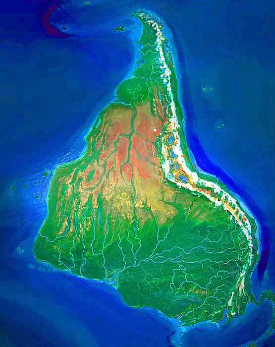
BOREALA
But the Turnovian forest doesn't end on Papua. I didn't think turning Australia on its head would make it unrecognizable, but... behold the legendary Northern Continent! Let's call it Boreala, "northland," as Australia meant "southland." Australia was red; Boreala is green. From Darwin to Perth to Adelaide, the whole east is millions of square kilometers of forest and prairie. A chain of Great Lakes nearly cuts the continent in two--Lake Simpson, Lake Eyre, Lake Torrens, and half a dozen others. Only the Darling Basin, west of the low, pine-clad Flinders Range, is still red desert. Well, the central west coast is dry too, especially around the Great Barrier Reef--desert above water, paradise below, like Baja California. To continue the analogy, Victoria and New North Wales, further north, are a fertile ecological island much like California, though linked to the fertile east by a migration corridor from Adelaide to Melbourne along the wooded north coast. Oregonian Tasmania is just offshore, also nearly linked to the mainland, due to lower sea levels. The Tasmanians won't lose contact with the mainland and dwindle culturally and technologically, as they did in our world.
CHINA AND SIBERIA
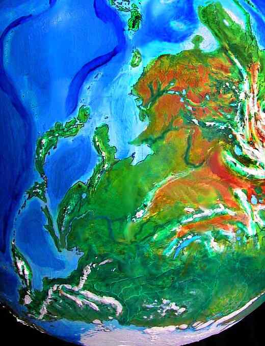
The Pacific coast of Asia has drastically changed. In the Tonkin Gulf, Hainan Island has linked to the mainland, creating a Korea-like peninsula with a dry monsoon climate. To the south, China is a desert, one of the greatest in the world. The Yangtze and the Yellow River, even Vietnam's Red River, all wind through desert hills, forming great irrigable floodplains like our Nile. Will pyramids rise here (or in the Mississippi Delta) before Egypt? Coastal China is somewhat Mediterranean; think of Korea as Greece and Japan as Italy. Inland, Manchuria is mostly prairie, with year-round rivers flowing from the mountains; picture a wetter Fertile Crescent. Sakhalin Island has grown so much it may link to the mainland too; it's cool and rainy like England. Kamchatka resembles Norway, or British Columbia, with huge forests and salmon-streams and mild winters for this latitude. All around the Seas of Japan and Okhotsk, and even inland over the mountains, the Pacific Siberian forests are thicker and the winters much milder; parts of the Antarctic coast are forested, especially the Lena Delta. The woods form a great triangle from Hokkaido to the Bering Strait and narrowing to the east, all the way to the Urals--reversing our world's triangular Russian taiga, thicker in Europe, thinning in Siberia.
The relative warmth and fertility of Pacific Siberia has enormous consequences for Turnovian history. In our world, Siberia was nearly uninhabitable till the last ice age waned, preventing settlers from entering the New World until 15-20,000 years ago. But Turnovia's milder Siberia means people could reach the New World tens of thousands of years earlier--maybe even before Boreala. And as with Boreala, the earlier introduction of more primitive hunters would give Ice Age megafauna more time to adapt and survive. The mass extinctions humans bring would still happen, and this doesn't mean New World civilizations would necessarily domesticate cattle, horses, or camels, but it increases the odds they'd have some large animals to domesticate--and far more time to work with both animals and plants. The hemispheres are more likely to develop in technologically in tandem, fueled first by land-route trade with Kamchatka and Japan, and later by sea-trade between Canada and Sahara.
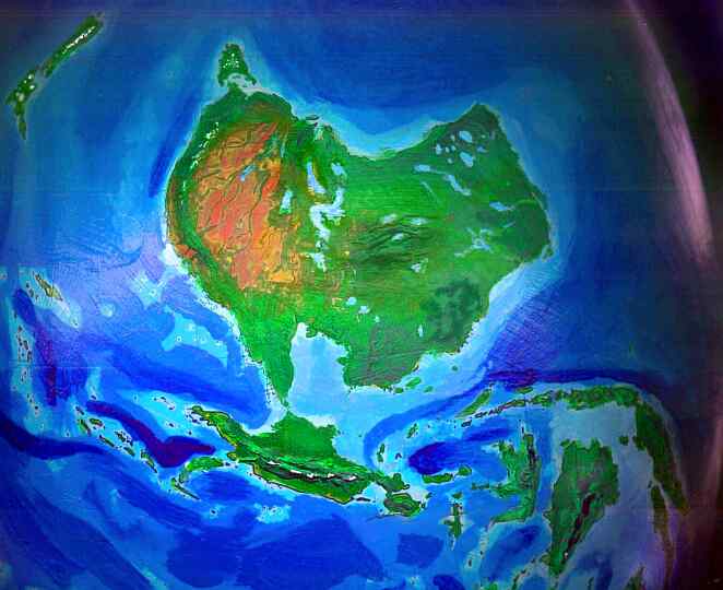
TORTOLIA
North America is now south of South America. To avoid confusion, let's call it Tortolia, after the native name, Turtle Island.
Tortolia's Pacific Coast is wet. Lacking any capes to deflect the warm California Current, and with high mountains blocking Antarctic storms, it's fairly mild for an eastern continental coast. California, balmy and humid, has an inland delta worthy of Louisiana (or Cambodia), which narrows, gathers and pours through the freshwater San Francisco Lagoon, out the Golden Gate, and winds through the coastal jungle to the sea. The Sierra and Cascades have some of the densest snow packs in the world, and the tallest broadleaf trees. The fall colors in the foothills and along the Oregon coast will be famous...
Beyond the mountains, the Utah Sea never dried up, nor did Lake Lahontan in Nevada or a dozen others, dotting a patchwork of prairie, forest, mountain and canyon much like East Africa at the dawn of man. It's unlikely apes would make it here and evolve into protohumans, but with a Bering landbridge appearing in mildly cool eras, it can't be utterly ruled out. Winters here can be cold, but the land is much more fertile than our American West, and isn't split into ecological islands like California and Central Mexico with deserts between, but forms one rugged but unified zone we'll call Ecotopia, from Guatemala to the Yukon. Plants and animals can spread north and south here by climbing the slopes to find the right temperature and humidity. Once Ecotopia is settled, trade in crops and unified empires like the Inca will be possible, rather than the fragmentation of our world's North American tribes.
Beyond the Appalachian pine forests, the West Coast is Mediterranean from Georgia to Cape Cod. Redwoods cover New England and parts of the Great Lakes. The Maritimes, Quebec, and Hudson Bay are lush forests with fairly mild winters, due to the warm Spanish Current I mentioned, pouring up past Iceland and southern Greenland to bathe Labrador and Baffin Island. The fabled Southeast Passage is tree-lined on its northern shore, and stays ice-free even in the severest winters. A plume of relatively warm water even reaches the Beaufort Sea off Alaska, pushing back the ice and exiting via the shallow, shrunken Bering Strait. In our world, the Canadian treeline is startlingly diagonal, slanting from the Arctic sea at the mouth of the Mackenzie River down to Labrador in the east. In Turnovia, the slant is reversed: Greenland and Baffin's subarctic coasts are densely wooded, while the McKenzie River and Alaska, at the same latitude, are mostly tundra--colder than the Siberian coast across the Bering Strait.
CARIBBEAN
The Caribbean has many new islands, and existing lands have grown; for example, Andros Island now dominates the Bahamas; it's nearly the size of Florida. Both Andros and Florida are Mediterranean in climate and quite dry inland. The Everglades (just below Florida's hundred-mile-long "Cape Keys") are an oasis in a sea of dry scrub. The Gulf and the Caribbean have more islands and reefs than ever, due to the lower sea level; but the region's recognizable.
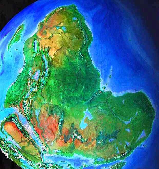
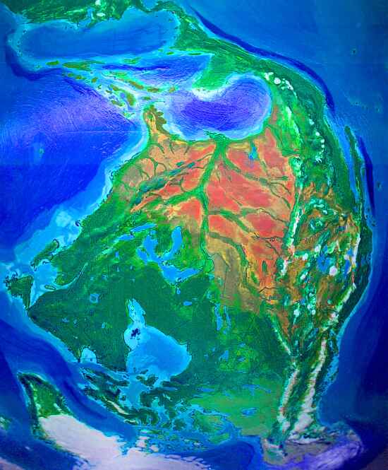
ANDEA
We certainly can't call this continent South America: it's now the northernmost land in the world, after frozen Arctica. Let's name it Andea, after its most fertile, spectacular region. From Panama all the way up to Chile, Andea's east coast is evenly lush, including our Atacama Desert. This Pacific slope forms a north-south migration corridor like the Ecotopian strip on Tortolia. While temperatures rise in the equatorial part, the huge altitude range of the Andean slope compensates, allowing temperate-zone plants and animals to spread more easily north and south than anywhere else in the world. This makes Andea less biologically stratified or isolated than our South America--though steamy Panama remains a barrier.
The Chilean and Bolivian Andes are a bit rainier; Lake Titicaca has grown, and has four huge sisters: Poop�, Coipasa, Uyuni (larger than Titicaca) and Atacama--together, some 50,000 square kilometers of water. These moderate the climate of the altiplano--it's no warmer, but much grassier. The Incas will have a much higher population base...
The Amazon Basin is still rain forest, but not quite as wet, especially in the deep interior, near the foothills of the Andes (I'm making an analogy with our Congo). But to the north, the rains fade gradually like Africa's Sahel--the forest breaks to savanna, grassland, and finally the Parana Desert, an ill-defined dead zone larger than Argentina. The Brazilian coastal mountains catch enough rain to be wooded, but the lowlands and canyons are also quite dry except for river banks. It feels Australian--a green coast with mountains and canyons fading to red desert inland. The cool Brazil Current is deflected offshore around 20 degrees north by a new cape and reefs exposed by lower sea levels; south of this, tropic storms make the Bahia coast jungly and lush.
Uruguay? Argentina? Think Oregon or France. Rains are reliable and climate mild, milder than in our world, and this effect (due to a shift in currents) gets more pronounced further into Patagonia, which is much warmer and greener. The full force of the warm Benguela Current shoots from Cape Town across to the rather Icelandic Falklands and Scandinavian west coast. Patagonia is pine forest, instead of our windy barrens. The land is wider, too, for the shore is very shallow and sea levels have dropped.
The Chilean fjords east of the Andes, caught in a cooler eddy, are colder and treeless; it's the only part of the Pacific Coast harsher than the Atlantic.
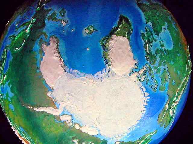
ARCTICA

Arctica is the logical name for the huge, ice-capped continent covering the North Pole. Sealed off by a ring of cold currents at 60 degrees north, it's the least changed of all the regions. Still, Palmer Land, that long icy cape facing Patagonia, now gouges into the prevailing currents like a claw, instead of trailing like a bent reed. The long hook scoops relatively warm water along the peninsula's west face, freeing a thousand miles of coastline from the ice. This Arctic oasis resembles our southern Greenland, and is crowded with strange species, the last survivors of Arctica's ancient fauna and flora. Further north, the Ross ice shelf has retreated closer to the base of the jagged Vinson Massif. Across the pole, the jagged Transarctic Range leads to fuming Mt Erebus, the great volcano standing alone near the sea, upper right.
Despite the Peninsula's partial thaw, the total volume of ice slightly exceeds Antarctica's, for Arctica is slightly larger in area, due to the lower sea level.
BIOLOGY
Overall, Turnovia is probably more fertile than our world. There are obvious regional losses--China, Europe, the New World deserts--but a million square miles of new coastal lands and islands (from the lower sea level), and the immense new tracts of fertile land in Sahara, Boreala, and Siberia, more than balance this. Further, the New World and Boreala probably have richer fauna, even in areas where they are no greener. This seems counterintuitive, but consider: the oldest human-inhabited continent is Africa, and it has the most large animals. Second oldest is Eurasia, and it has the next richest megafauna--elephants, tigers, camels, ancestral horses. Australia, the next, has very little; but it's small and dry. Next come the Americas, a very large fertile land, yet they too have very few really large mammals. Bears, bison, moose... what else? The most recent human-settled lands, Madagascar and New Zealand, have no large animals at all--we ate them all within a few generations. Jared Diamond has explored the reasons "Guns, Germs, and Steel," but here, let's just say that exposure to earlier, less skilled human hunters is like inoculation, and led to a higher survival rate--to coexistence. Turnovia's narrow straits encourage earlier settlement--and thus, the survival of more large New World and Boreal animals.
Arctica has no megafauna. While the Arctic Peninsula could support herds of reindeer and musk ox and mammoths, and human hunters would be unlikely to reach them until quite late in history, Turnovia's climate is probably as unstable as ours. The peninsular refuge has grown and shrunk, over and over. Small animals and flowering plants may survive, for their populations can crash, migrate to the tip, and recover. Large mammals, needing a certain territory to maintain a viable population, wouldn't survive the cold spells.
Speaking of large animals... in Turnovia, the great apes aren't trapped in Africa. Dense coastal forests stretch all the way to the Mediterranean, and via either coast, they could then spread through lowland and montane forests west across Eurasia. Few deserts stand in the way. Clearly at some point this happened in our world, despite the climatic difficulties, since orangutans live in Indonesia. But such spreading is a lot easier on Turnovia; the subtropical Eurasian east-west corridor is more uniformly green. True humans might first evolve on the Pacific or Indian shore. If so, the first settlers to make it to Boreala and the New World might be even earlier than I've posited--a million years ago or more, instead of a mere 60-100,000 years ago. Truly different subspecies or even species of people might develop.
CULTURE
With zones much like our Fertile Crescent in Bengal and Manchuria, and in Tortolia over an easily crossed strait, and in nearby Boreala (though it's a longer boat/raft ride, to be sure) there's a chance farming and herding would start far from our Mideast; though I think that convenient corridor from Japan to Morocco would quickly spread domesticated plants and animals far from their cradles. The sheer size of this trading area stimulates speedy technological development--see Jared Diamond's "Guns, Germs and Steel" again.
But the greatly increased fertility of Boreala will have cultural effects. In our world, Australia wasn't just held back by isolation; the total population was low, so there were few innovators. Australia, on the eve of European invasion, held only 300,000 people. New Guinea, a tenth the size, had four times that! But on Turnovia, the Torres Strait would probably be a land-bridge, pooling these populations; and even Boreala in isolation is so rich it could sustain many millions! It's as if China had been an island. A big enough population-pool to speed innovation? Certainly. Would it be enough so Borealans would build ships and spread over the Pacific and Indian Oceans, exporting the Dreamtime to Madagascar and Hawaii?
A warmer Siberia not only extends the fertile trade-corridor several thousand miles further, but provides an easy gate into the New World. So New World civilizations would have a long head start over ours--tens of thousands of years longer, at least. But how quickly would the irrigated agriculture of the Mississippi Delta and Mexico spread south to the cooler fertile zones of Quebec and the Great Lakes? Similarly, Andeans and the farmers of Parana and La Plata might or might not trade crops and animals and ideas. The Andean civilization might unify faster with a long, unbroken fertile corridor along the Pacific slope. But would Ecotopians, Mayas, Incas, Mississipians, Quebecois, and Platans contact each other, giving the New World a chance to reach parity with the Old? The Ecotopian and Andean corridors form better north-south highways than the desert-broken paths in our world, but the Caribbean still splits the New World in two, slowing the spread of temperate-zone crops. I think it's clear New World civilizations would start earlier and integrate faster than on Earth--but fast enough?
Who would make first contact? Would the Vikings of Spain and France land on the Grand Banks, or Basque fishermen from Gibraltar or Morocco (Oh, there will always be Basque fishermen. Trust me--there were Basque fishermen on Mars three billion years ago)... or some better-funded Senegalese Columbus?
Or would New World ships reach Polynesia and the Sahara first, to spread their wonder crops, corn and beans and potatoes and sunflowers, around the world?
"The grass always looks greener on the other side of the fence."
That old proverb isn't about jealousy, as most people think. It's subtler than that. You see, it's literally true. When you look at grass you stand on, you're looking down--you see the leaves end-on, so a lot of bare earth is visible too. When you look over the fence at your neighbor's grass, you see it full-length, at a low angle, so the grass-blades overlap and hide the ground. Even if your lawns are identical, your neighbor's grass really does look greener.
And this effect crops up in other places. Ever notice, on a busy, multi-lane road, how you always get stuck in the slowest lane? Lady Luck isn't out to get you--by definition the most crowded lane will have the most people in it! Clear, fast-moving lanes have fewer drivers. More often than not, you really ARE in a worse-than-average lane, the other lanes ARE greener--till you move over, and slow them up!
Now, the opposite principle applies to alternate earths. Consider:
Let's say you're contemplating Randomia, an alternate Earth no better or worse than ours, with roughly the same biomass, same amount of arable land, about the same population... just re-distributed. Now, what regions will you notice the most? First, your home, of course, and then, other well-known regions--and well-known means inhabited.
Randomia will always look inferior! For, by definition, most readers will be from our world's high-population zones. Random changes will, on average, degrade them. And the lands that improve, that become the heartlands of Randomia's civilizations, are likely to be barren obscure lands in our world, mere names (if that) to non-Randomian readers. The Turnovian version of Europe is cold (millions of European readers groan), while the green Sahara nurtures great civilizations (a handful of Saharan readers cheer). If you love civilization, Randomia will probably kill or cripple the ones you love, and plant its greatest civilizations in places you associate with backwardness.
So the grass always looks browner in a parallel world--because what you value most, what you KNOW to value, is generally lost. This principle makes it hard to see alternate worlds fairly.
So, if I seem foolishly optimistic about these alternate Earths, postulating island leagues and tropical civilizations and intelligent lemurs or elephants or mega-ravens... just remember I'm fighting the Randomian factor. Your view is colored by the degradation of what you know and love; so my predictions of new growth and life in the unlikeliest regions, will seem fatuous. Yet they grow from the same data as the doom and gloom--your perceptions are naturally tilted toward seeing the losses. Factor Randomia in, before you mock.
THE LESSONS OF TURNOVIA
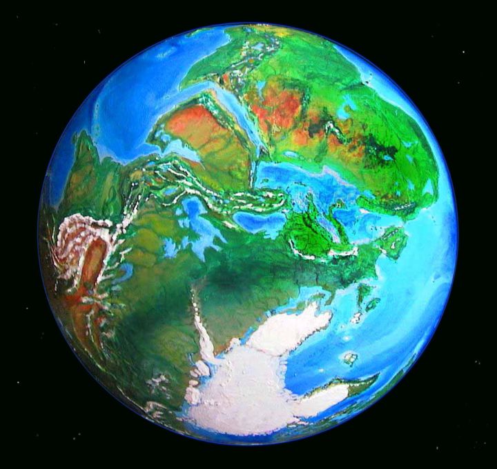
People who've seen my globe of Turnovia always comment how lonely it looks--blank and blue as a blind staring eye, with Arctica as the milky pupil. We normally look down on globes of our Earth, so we first see the northern hemisphere, which is 40% land--but when you first glance at Turnovia, the hemisphere you see is 80% ocean! Even though Turnovia has a million square miles more land than our world, all that ocean is terribly visible. To us land animals, all that blue looks sad.

My original working name for Turnovia was... Subtilia. When I named it, back when I had only the raw premise, I expected subtle local changes and an identical sea level--a deliberate contrast to the spectacular deviations of steamy Seapole or dusty Shiveria. It was to be a drawing-room exercise in fine-tuning--Jane Austen, not Tolkien. But when I worked out the details, I was wrong. Subtilia's changes weren't subtle at all. The green Sahara and Siberia, the Chinese desert, the frozen Europe and balmy Canada and half-thawed Greenland and the lowered sea all took me by surprise. Particularly odd for me was understanding that currents and winds didn't always reverse--sometimes they deflect into completely new patterns.
I work a lot by analogy, not calculation, wherever I can. I look for similar latitudes and landforms and currents. Because I was so close to home, I hungered to do this more than in previous models. But I couldn't. Turnovia brought home to me that not all possible landforms exist in our present world. For example, long east-west coasts in the middle latitudes are rare--between the warm examples of Australia and South Africa and the polar example of Alaska-Siberia, we have few models to help us except the ambiguous one of the Mediterranean.
Of course, each alternate Earth poses new questions. For example, we understand thin air's effect on climate, from Tibet, the Altiplano, and Mars. But thick air? When our Mediterranean Basin went dry for a few million years, its air pressure doubled... with what ecological effects? Little research has been done--deep-sea paleoclimatology ain't easy. Yet my low-sea simulation, Shiveria, turned out to hinge on that nonexistent data. I had to reason out the consequences of a thick-air basin with only the weak example of the Dead Sea.
We really won't understand Earth's climatology till we've seen other biospheres--a lot of them. Nor do I think we'll truly understand our own evolution till we've met species that evolved from other creatures.
Damn.
One lesson I learned is perhaps only relevant for other world-builders: I was surprised by how much more cautious and uncertain I felt about this scenario, closer to home. With tropical, drowned Seapole or stark, Marslike Shiveria, I felt free to go to extremes--they're extreme and unfamiliar worlds. I'm the world's authority on them! But with Turnovia, much smaller doubts loom large--is Pakistan as green as I say, is Siberia really that mild, how much of Greenland thaws, how cold does Europe get? Everyone's gonna be on my case about these issues, after all! Too much is known. People with supercomputers can second-guess what I did with intuition and paint...
Oh well, science fiction's harder to write than fantasy, and the closer to home it is, the harder it gets...
NEXT!
It must be obvious that Jared Diamond's "Guns, Germs and Steel" is much on my mind these days. Its thesis is that civilization developed in Eurasia first and fastest for clear ecological reasons--early settlement, good domesticable species, and east-west trade routes (so domesticates could be easily transplanted). I'm planning a tribute to Jared: a tilted Earth that encourages faster and relatively even growth of civilization. I intend to find a tilt creating the world's widest possible east-west zone, probably in the Americas. Their current north-south orientation meant the supercrops of corn, beans, sunflowers and potatoes were trapped in small climate belts for millennia. But if Native Americans had lived all at one latitude, would they catch up to or even surpass the Old World? I don't know if it'll work out, of course, but that's what makes it fun.
However... I may soon take a short vacation from my game of tilt-the-axis. Instead, I plan to build our familiar world, with its axis un-tilted--but our world as it'll be if carbon dioxide stays high for a million years or so. Our current geography, but with CO2 at, say, 600 or 700 parts per million--enough to melt Greenland and Antarctica. Once the world stabilizes, if it ever does, what'll it look like, that flooded greenhouse Earth we're so busily creating?
I think I'll name it Dubia, a doubtful world. No, I lied. It's really named in honor of the world's foremost advocate and producer of greenhouse gases--both via his oil/car policies and his hot-air speeches. George W. Bush.
Dubya.
Coming soon. And, I'm afraid, coming for real.
World Dream Bank homepage - Art gallery - New stuff - Introductory sampler, best dreams, best art - On dreamwork - Books
Indexes: Subject - Author - Date - Names - Places - Art media/styles
Titles: A - B - C - D - E - F - G - H - IJ - KL - M - NO - PQ - R - Sa-Sk - Sl-Sz - T - UV - WXYZ
Email: wdreamb@yahoo.com - Catalog of art, books, CDs - Behind the Curtain: FAQs, bio, site map - Kindred sites