Capsica's homepage, map, giant ref map, geography, gazetteer . More worlds? Planetocopia!
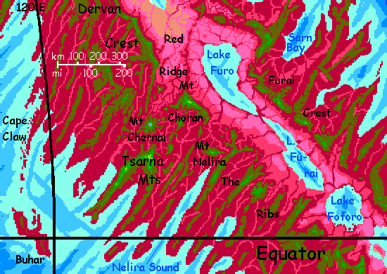
 Capsica: East Arch (north of the Canal)
by Chris Wayan, 2020
Outline only!
Capsica: East Arch (north of the Canal)
by Chris Wayan, 2020
Outline only!
Introduction - Touring - Northeast - East - Strait - Rift Crossing - Canal - Lakes West - Northwest
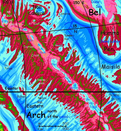
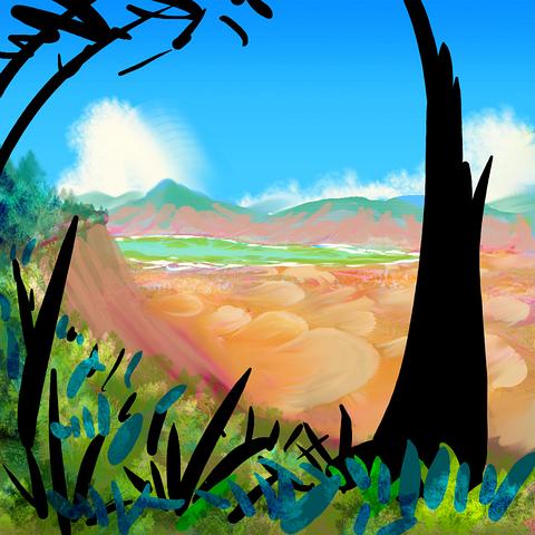
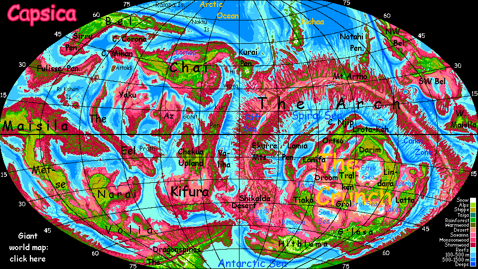
The Arch is Capsica's largest spreading zone, where new crust emerges from a rift. This valley, thousands of kilometers long, is flanked by twin ridges, typically 3-4 km high (10-13,000'); around these are a maze of lesser ridges, as the new crust meets resistance from older plates, and corrugates. It's not simple folding, either; parts of the rift spread at different speeds, and the boundaries between these conflicting conveyer belts (called fracture zones) rub and grind, pushing up lesser ridges and valleys at right angles to the Rift. The result looks like a ruined city built by giants, full of gaps in the walls and barriers blocking the ancient streets.
In short, it looks... fake. But in fact, Earth has millions of square kilometers of terrain like this! It's just nearly all hidden under miles of sea. This stretch is quite like our Mid-Atlantic Ridge--but on Capsica, with its lower sea levels, these weird landforms are exposed.
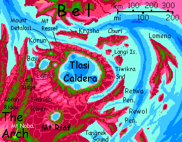
In some stretches, both on Earth and Capsica, hot spots break through this rift-zone labyrinth, building shield volcanoes; if persistent enough, a hot spot can build a whole chain of monster peaks or (if the local magma has a lower melting point) low but immensely broad calderas. This eastern region has one field of these vents at the north end; Tlasi Caldera proper, the widest by far, is gigantic--an oval 250 km long and nearly 200 wide (150 by 120 mi). It's Capsica's biggest; even Jupiter's volcanic moon Io can't match it, though Loki comes close.
All of the Arch is a spreading zone--its crust is new, moving a lot, subject to quakes, full of faults and fissures, volcanoes and geysers and hotsprings. Is this changeable, harsh topography hard on life? Well... not very. Since about 30% of Capsica's entire land area is corrugated rift-zones, life is used to these conditions. It's just that you won't necessarily be.
This stretch is the lowest and narrowest in the Arch; so low that near the equator the rift's east rim was breached by the sea. Not far away, the west wall is so low that two sluggish rivers nearly meet. Here, a canal is under construction. At present, only modest boats can cross, and in the dry season, only small craft. But eventually the Arch Canal will shorten major shipping routes by up to 30,000 kilometers (19,000 mi)--quite as important for Capsica as the Panama or Suez Canals are for Earth's economy. Not for news or passenger travel, of course; in Capsica's dense air and low gravity, everyone NOT carrying tons of lumber or iron travels by air. Ten times faster!
Intro - Touring - Northeast - East - Strait - Rift Crossing - Canal - Lakes West - Northwest
If Capsicans were human, the endless fractal capes and 'fjords' walled off by high ridges would isolate each community, discourage land-travel, and encourage sea-travel. It did in Norway--and Hawaii. But Capsica has low gravity and dense air. Flight is easy, even for human-sized creatures. So the dominant life-forms will almost certainly be winged. For them, those wind-catching ridges are flyways! Those that stand across the wind create reliable updrafts stretching for days of easy travel. The ridges flanking the Rift, especially, are transcontinental freeways. From them, fracture zones offer 'onramps' and 'exits' leading to other continents. This huge, simple, consistent flyway system, way more regular than the Outer Hemisphere's spotty flyways full of gaps and sea-passages, led the Arch to dominate culturally for centuries. Communication is civilization!
Humans are weak and lack hollow bones, but in this gravity, in this air, with strap-on wings you can fly. Not elegantly, not strongly; I'll forbid some popular native routes you can't handle. But you can get around. That's good, since Capsica lacks passenger transport--shipping is well developed, but it's almost exclusively cargo. Fliers get bored sailing at a tenth or twentieth the speed they can sustain under their own muscle power. Even you, riding updrafts, should sustain 50-80 kph (30-50 mph); ten times walking-speed, way faster than a bike or ship; comparable to car or rail.
I'll start this tour in the northwest, coming from Tlasi Caldera, and lead you south along the eastern rim of the Rift past the equator and over Seluria Strait, across the Rift to the west rim and up to the Arch Canal, Capsica's greatest civil engineering project--a river-linkage will eventually let cargo ships cut up to 30,000 km (19,000 mi) off the torturous route from the Crunch and Inner Arch to the Outer Hemisphere.
From the canal, we'll head back north along the West Rim. Though crossing back to Tlasi Caldera won't be easy.
Intro - Touring - Northeast - East - Strait - Rift Crossing - Canal - Lakes West - Northwest
We'll start where tours of the main Rift Valley and Tlasi Caldera part ways--on Last Ridge. The name's an exaggeration, but the Tlasi region to the northeast does breaks the usual pattern for the Arch; for hundreds of km south and east, there are few other high ridges generating updrafts. Inconvenient for Capsicans, who can grit their teeth, beaks or probosces and just fly under their own muscle power. It may hurt for a few days but it won't kill them.
It will, however, kill you; this stretch of the Arch south of Tlasi is just too hot and humid for Terran life. We're just 15° from the equator; even now, in early winter, it's 50-60°C most days (122-140°F). And steamy, too; you can't cool by evaporation in the Riaf Basin.
So... the only route south toward the Canal for us is down Last Ridge to the rim of the Arch Rift, the spreading zone creating this whole strange landmass. Trade winds slam into Last Ridge, so you can float along in those rented wings, learning to steer without working too hard. Yet.
After a long sticky day, you camp on the south shoulder of Mt Noba, a volcano 5200 m high (well over 17,000'), with a jagged, broken summit where some eruption blew half the crater out, leaving crooked fingers reaching into the blue. No snow of course, not at a mere three miles high; not in the Capsican tropics. This isn't Mt Kenya, even if it looks a bit like it.
The south slope of this great peak drops nearly to sea level--a dim pink and lilac carpet far below you; the colors of healthy savanna. Most of the rift floor is desert, cut off from sea winds and rains by the flanking mountains; but here they're broken and the rains heavier as we near the equator.
On the horizon, shimmering silver. No, not a mirage, despite the oven-heat down there. That's shallow Lake Geh, an oval 150 by 95 km (95 by 60 mi). Unusually for the Rift, it's freshwater; it drains northwest to the sea.
That maroon snake across the savanna carpet is the Geh River, or rather the mile-wide band of trees on and in its floodplain. The river's low now, in winter. When the moonsoon hits in summer, the highlands feed the lake and those massive-rooted trees get a soaking.
East along the Rim two days.
South to Lake Filla. The rift floor is drier here--patchy pink scrub and dry grass over golden rock and even a few pale dunes. The lake's fed almost entirely by streams from the rimwalls. The blue eye's got maroon mascara round it, though. Rhodophore trees. That proves it's fresh water, and fairly stable; because it drains north to Lake Geh. Without Geh's outlet to the sea, this whole valley would be harsher--salt-poisoned.
South another day. Drier down there. Extensive dunes below--beautiful tawny crescent patterns. The flanking ridges are a bit higher here, cutting off most rain to the rift floor. Up top, it's just as green.
I think we should detour to Mt Pserida, tallest mountain on this trip. 6.1 km (20,000'), higher than Kilimanjaro. Summit and shoulders are, yes, yellow-green--high meadows. On Earth such tropical heights are above most clouds and rain, and tend to be barren; but with Capsica's dense air and low gravity, rain reaches much higher. Rocky fern-fields and hanging meadows.
To the north, pink savanna hills and a pale, shallow lake. To the east, streamers of cloud wreath rougher, deep-red ridges, reflected in a second lake seen only in glimpses through the clouds. Only that one's no lake! The sea--an arm of Tangrek Sound. The Arch truly is narrow here. Just a few hundred kilometers from Rim to coast; and the western Rim is equally narrow.
Next day you head due south, rejoining the East Rim about 200 km down from where you left it. It's green-wooded, much the same... but down in the Rift, things have changed.
Lake Surtash! If you're a veteran explorer of Capsica, that name will sound familiar. There's a high mountain in the western Arch (thousands of kilometers from here) called Surtash too; it's not a place-name. (Anyone so geeky as to consult the Gazetteer to find the origin of the name Surtash... will find out.) Anyway the word means a pale or yellow-green--logical for a high but snowless Capsican peak, since many do have extensive alpine meadows, and greens look exotic and memorable to Capsicans; but it's strange for a lake way down in the hot . You'd think.
Until you see it. It is. Lake Surtash has no outlet, and has built up a unique mix of salts; halophilic bacteria have turned it a vivid yellow-lime-green. Instead of the red wooded rim you've come to expect around Capsican lakes, saltflats, white stained puke-green, crust the shores. Ugh. Bad country; even Capsicans avoid it. The only drinkable water's from creeks dropping off these heights.
Salt desert below. Green forest above. Hot sun. Might as well be high summer on the Mogollon Rim on Earth. Except...
Late next day, a red-orange abyss opens before you. Here the East Rim fractures into lonely mesas and pinnacles like Monument Valley, with abysses of ovenhot air between them you have to fly over. Perfectly possible, but the only reachable campsites and water are atop the larger mesas. For the next day or two you zigzag and hop, forced away from the Rift proper. As long a detour as Mt Pserida, but this time it's a forced march.
When you do re-attain the crest, looking down on the rift floor, it's split by a low stony ridge, just 2.1 km high (about 7,000') right across the Rift floor, meandering, forking, even breaking into mesas for a while, but never failing. It's high enough to snag some rain, and sustain a broken, open forest of low red heat-tolerant trees; bloody streaks down each hanging valley and chasm.
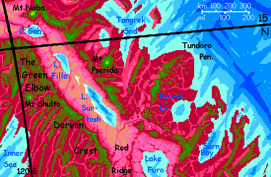
Red Ridge is no fluke; its fracture zone crosses the Arch entirely, northeast to southwest, thrusting up higher transverse ridges than usual on the Arch's outer flanks too--the Tundoro Hills, the Tsarna Mountains.
Capsicans find Red Ridge very convenient; the ridge blocks northbound winds in summer, and southbound breezes in winter; year-round updrafts for the canny flier. Unfortunately, you have neither the heat-tolerance nor the endurance to cross here; you need to be 3-4 km up to survive, and Red Ridge runs 320 km (200 mi) with no place high and cool enough for you to rest or sleep.
Intro - Touring - Northeast - East - Strait - Rift Crossing - Canal - Lakes West - Northwest
The palette of the Rift Desert was brown gold and white--rock, dune and saltflat. But south of Red Ridge, a new decorator's in charge--earth tones are out, pastels are in. Pale pink, Capsica's reliable marker of dry grass, with streaks of lavender. Capsica is full of ranges casting rainshadows; Red Ridge casts a salt shadow. The astringent dust blown off the shores of Surtash rarely makes it over Red Ridge. And the land appreciates it.
By next day you look down on great flats of a surreal lilac--the color of growing grass! Red snakes loop south--brush and trees along creeks. Twin reasons--we're nearing the equator and storms on the outer slopes of the Arch are frequent and strong as any Earth hurricane, while the mountains flanking the Rift, while high in spots, are on average lower than usual. More rain climbs over, feeding rich savannas.
East for a day. The pastel palette grows. A shimmering turquoise on the southern horizon--your first glimpse of the region's biggest lake, Furo. Not for the last time, though it recedes the next day--the Rim here runs east a couple of hundred kilometers, then makes a sharp elbow south. And you have to follow. Skittish chicken, not baked chicken.
Late next day, Furo returns, to the west of you now, and soon right below the Rim wall. Pink, lavender, scarlet shore, blue-green shallows, azure depths. Get used to that palette. Furo is a good 400 km long (250 mi), and it drains into Lake Furai, just as long, if a bit narrower--not that you can tell! For you, both extend to the horizon.
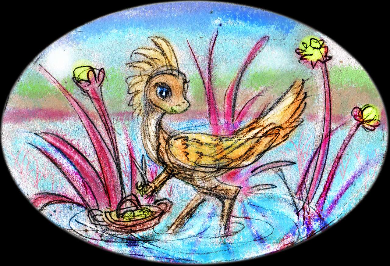
Both lakes, being equatorial and in the sunny Rift, are extremely hot--hot enough to scald a human. Unusually for the Rift, they're freshwater, since they drain into a third Lake, Foforo, and thence to Torlash Sound. Drainage matters! Their shores are stable, and lined with trees; the shallows full of reeds. Rich marshes support flocks of... well, something winged... so big you can see them from miles above--white and yellowish speckles. The first yellow you've seen on this world, as shocking as a cloud of pink flamingos on Earth.
You'd have to see them a lot closer to spot the scissors and the floating baskets full of snipped seedpods.
Long days to fill in here--the three lakes together stretch a good 1200 km (750 mi).
At last the sea. Torlash Sound.
Two days days along Abeito Crest.
Past Tigen and Paho--islands each 100+ km long, though for you, even from your miles-high vantage, they're just pinkish clouds on the western horizon.
A gap--a canyon full of raw orange and white sandstone cliffs. Forty km of careful weaving from mesa to mesa, following updrafts, only to sink again over shady canyon depths. By this point though, Dear Reader, I have no fear for you.
The cliffs of Torlash Front--a wall worthy of South Africa's Drakensberg. Green-streaked up top, where creeks launch off the Rim, red-streaked and dotted at the foot, in that other, oven country.
A full day southeast.
A narrow green fin, Tseniru Spur, leads out into Torlash Sound. It's a popular local flyway leading across the Rift to the Canal, and that green marks it as just high and cool enough for Terrans; but the ridge dead-ends in a cape, and from there to the safe heights of the West Rim it's 360 km (225 mi)--though it points straight to the Canal our goal, it's just too wide a gap. We'll have to go south to a narrower crossing.
Soon after Tseniru Spur, a gap in Torlash Front--but you veer east an hour till it narrows to just 25 km (15 mi)--nothing to you now.
One more day southeast along Torlash Front, and it ends abruptly. Blue beneath you. Not the tropical turquoise shallows of Torlash Sound, but profound blues marking real depth on this world of shallow seas. A fracture zone that's really fractured things, down to Capsica's core by the look of it.
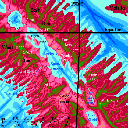
You're looking down on Seluria Strait, biggest breach in the Arch.
Rest up. You have to cross it.
Intro - Touring - Northeast - East - Seluria Strait - Rift Crossing - Canal - Lakes West - Northwest
Seluria Strait is quite crossable--just not easy. Only 50 km of water, but over 100 km from highland to highland.
By day, the deep sea is cooler than the land. That sounds good, but isn't! Cooler air generates downdrafts. You'd have to cross on musclepower alone, fighting this down-current. And it's still hot enough down there to kill you--50°C instead of 60 (122°F, not 140). Slow death instead of fast.
So... we'll cross at night! The temperature difference between land and water shrinks and vanishes; the air calms. Night-breezes blow toward Torlash Sound, a mere crosswind, nothing hazardous.
Still a long way, but at least now it's just an endurance contest--miles versus muscles! The landscape, or rather airscape, isn't sabotaging you.
South of the Strait, the Belnar Hills... camp and rest up a day. You need to. Sore shoulders. If they're really sore you can alway drop from the peaks (3.5 km, 11,500') down a kilometer or and sit in a creek for an hour. Might as well be a Terran hot tub. Bake that soreness out! Just don't overdo it and die. Remember the air's even hotter and too humid for evaporative cooling; and you have to spiral back up to camp.
South half a day, then a shorter gap--65 km west (40 mi), crossing the mouth of the Lirwa River. Low hot country, fatal if you falter, but that very heat generates updrafts that make this passage far easier than Seluria Strait. Feels like a hair dryer under you, blowing you upward--three miles up--sweaty, but alive.
The Lirwa drains great marshes and savannas to the south. The influence of the Sound--over 1000 km of sea--goes deep inland up the Rift. Lakes, marshes, patchy woods and healthy savanna for days... no desert.
Rest up in the Center Hills, then south a day or two along narrow Lirwa Ridge in the heart of the Rift. Water's a problem--the green ridgetop is narrow, with no surface water; if you swoop down the steep face low enough to find a creek in a hanging valley, the heat may dehydrate you more than you gain from the water you win. Ask locals about the highest springs on the shady side of the ridge (whichever it is). There will be locals--this is the highest, coolest, easiest flyway across the Rift for thousands of kilometers. This is the equator, and hot for Capsicans too. It won't kill them down there, but they too appreciate these cool heights.
To your left, the Lirwa Marshes, a scarlet plain full of winding turquoise veins and pools; to the right, the drier Chabi Valley, lilac grasslands with a red strip down the middle where the river drains two great riftlakes, Chabi itself and Karok upstream. Between, this narrow ridge of cool green forest. Cool being a relative term.
Chabi Narrows, where we see the great curve of Lake Chabi to the south. It's freshwater only because the Narrows exists--a gap where water could punch through the Rift walls to reach the sea.
On the horizon to the east, a huge pale-green peak--Mt Elkani, the highest volcano in the Straits region, 5.3 km (17,500'). If we were heading further on down the East Rim that'd be our base camp and navigation beacon for days, but that's another tour--have I even written it yet? And on THIS tour it's time to head west and north to the Canal. (At last, you say.)
Intro - Touring - Northeast - East - Strait - Rift Crossing - Canal - Lakes West - Northwest
Cross the Narrows. Tedious. Hot. Muggy. Right on the equator and you feel it. About 100 km--updrafts, not a hard technical flight, but a couple of VERY tiring hours just the same. With that big maroon carpet of death by steaming, sprawled out two miles beneath you.
Long days now skirting the Falga Basin, a lowland 300 km across. No huge gaps like crossing the Rift, but lots of short ones. A maze of high and low ground.
South side, west a full day over gaps till you see a gleam of blue to the south--the western sea, at least some inlet--then northeast...
Through the Kai Hills. More than hills, really, but that's how the local name translates. A bit lower and more broken than the Rim's average, so the Kai gets no respect. What local fliers like is a nice spectacular straight cliff or mountain wall, both scenic and conveniently forcing updrafts in a line. Not this winding stuff.
Mesas and cliffs. Springs and savannas at first. Looks vaguely African.
Northeast a day, fitfully climbing a kilometer higher. You reach 3.8 km high (12,500') when a straight ridge heads northwest, holding steady at 3 km (10,000').
Slowly the land gets wetter. Trees in every crevice. We're nearing the Equator again, AND, to the east, the gap of Seluria Strait lets storms in--nothing like the rainforests outside the Rift, but less rainshadowed.
The widest gap in a week. And at the bottom, two modest rivers--joined. The most important place on Capsica these days. The...
Intro - Touring - Northeast - East - Strait - Rift Crossing - Arch Canal - Lakes West - Northwest
Really, it's just a dream--so far. The canal is still under construction. It has been for a century or more. Capsicans are taking their time and expanding it gradually--from an ancient small-boat portage to a shallow canal for small craft only in the wet season, now enlarged enough for midsize boats to cross during the high waters and small craft year-round. In another generation or so the next planned expansion will allow the Arch Canal to carry real cargo vessels (still microscopic by our standards--light catamarans under 30 meters long, carrying mere dozens of tons--but for Capsica that's large-scale). Major shipping routes, always tortuous on Capsica since the seas are so broken up, will shorten by up to 30,000 kilometers (19,000 mi)--quite as important for Capsica as the Panama or Suez Canals combined.
It won't mean a thing for news or passenger travel, of course; in Capsica's dense air and low gravity, everyone NOT carrying tons of lumber or iron travels by air. Ten times faster!
All you can see from your godlike, miles-high perspective, as you ride the heat spiraling up from the Canal Gap, is a little stream, unusally straight, dotted with bright-colored little boats. At several ponds, little clusters where boats in transit pay the canal fee--not money, the Capsicans don't readily think in those terms--but labor! Here they get their assignment--one day's work dredging a shallow or widening a narrows somewhere that's become a chokepoint. Sailors with shovels, kids with trowels and sand buckets... But Capsicans think long.
Glide on. You can't descend, can't even afford to linger of the Canal, really--it's a long flight across the Gap, and you have to reach the cooler Tayogai Highlands before you tire. At least it's not muscle work like Seluria Strait--plenty of updrafts over that hot low stretch of valley. Lilac grass, red oaks. With that one bright little bluegreen thread strung with beads. Hardly a thing to change the world!
A week's journey northwest along the West Rim at 3-4 km. Pleasant despite the equatorial heat, for some rains make it here from both the Sea to the west and the Sound to the east. The uplands get plenty of rain, so there's shade and water even on the highest peaks of the Tayogai Crest.
Your path has to zigzag, following the heights, but you're in no hurry. First day it's north all morning, a sharp bend east at noon, camp for the evening looking down at Torlash Gulf--your closest approach since crossing the Strait.
Next day's easy--west-northwest along the Rim. The sea recedes almost out of sight--Cape Paho. Pastel-purple hills far below.
Next morning the sea returns--but it seems far narrower than you recall from your journey south. Just a silver strip, then low red hills on the horizon. Not the East Rim--just halfway. The narrow sea-arm is Mono Sound; those hills are Paho and Tigen Islands.
On day three you cross the equator.
Intro - Touring - Northeast - East - Strait - Rift Crossing - Canal - Lakes West - Northwest
Here, as we leave Torlash Sound behind, the country gets a bit drier, and you have to choose between camping on summits--cooler, but no water readily available--or on shoulders or side canyons--water, but distinctly hotter.
And the gaps are relentless here. You're entering The Ribs, 500 km of washboard country--alternating ridges and fault-valleys with no contiuous West Rim at all. Ridges do get higher, generally, as they near the Rift--quite high enough for you to camp safely--but between are canyon-mazes little higher than the Rift floor.
You take it slow, just one or two abysses a day.
At last you reach something more substantial--Mt Nelira, 4800 m (15,800') at the head of Nelira Sound, that dark blue gash to your southwest. Over 600 km long but averaging just 75 km wide (400 by 45 mi), it's the first fracture-fjord you've seen reaching to within sight of the Rift.
Nelira Sound's not a solitary freak; the same fracture creates the sharp jag in the West Rim between Mts Nelira and Choran, then cuts across the Rift, bending Lake Furo, creates more gaps and bends on the East Rim, and ending in a twin gulf on the far side of the Arch, Sarn Bay. Between Nelira's head and Sarn Bay, it's barely 600 km (less than 400 mi); the narrowest point of the whole Arch--except the Canal itself.
West for a day, riding the winds halfway up Mt Nelira's long north wall.
Northeast, hopping between green-topped mesas a mere 3 km high (10,000'), to the Mt Choran complex. Rest and relax. Swim! The water coming down from Choran's heights is actually cool. It's 5.7 km high (18,900'). When you're high on its shoulder and under trees hiding that vast strange horizon, you'd swear it was a tropical Terran island.
Long peripatea here--that great fracture zone creating Red Ridge disrupts the West Rim too. You have to detour well southwest.
Volcanoes! This part of the fracture zone is a volcanic field about 300 km wide (200 mi). You follow a chain of lesser cones to Mount Chernai, the biggest. Camp on its crater rim, looking down those cliffs on the deep clear lake, as indigo as any on Earth. Like Oregon's Crater Lake, but two km higher up--the lip's high point is 4.8 km (15,800').
Morning: round the flanks of Mt Chernai to the north slope, and across a lowish olive-green gap (where, if you fell, you'd be in mixed forest, red and green trees together, mingling at a temperature of 40°C--100°F). And humid. You wouldn't die--just wish you would. And your body temperature, matching the background, would be mistaken for a dead thing needing to be recycled by all the rhodophore-zone bugs, bacteria and molds. Itchy fun.
Due north a day along the first ridge of Dervan Crest. This reliable flyway will be with us from now till the end of the tour--the longest continuous ridge in the Arch.
A lesser volcano to your right, visible all the next day. A mere Etna, a mere Hood. You ask its name, but no passing Capsican knows. Can't memorize every speedbump.
Intro - Touring - Northeast - East - Strait - Rift Crossing - Canal - Lakes West - Northwest -
Dervan Crest proper. The rim looks down on sere pink savanna, the last grass on the rift floor for a long while--desert from here on out. Past Red Ridge, we're creeping into the dry zone. Capsica's worldwide air circulation is much like Earth's; air heated at the equator rises, cools and descends at last, between about 15 and 30 degrees north--wrung of most of its moisture. Capsica's steamy seas can rehumidify that air faster than Earth's, so there's still rain on the outer slopes of the Arch, but the Rift gets pretty harsh.
It gets worse, of course.
Soon it's so dry down there it's all orange rock, white salt, gold sand. And green up here. If it weren't for the rare hardy rhodophore trees along streambeds, in hanging valleys right beneath you, there'd be no hint of red to remind you this isn't Earth.
Three days along the Dervan Crest. Higher than we've been in a while--3.6 to 4.6 km (12-15,000'), and farther from the equator, so camps aren't just bearable but comfortable. The West Rim's scalloped not straight; the "capes" are spectacular viewpoints, with horizons up to 250 km out (150 mi)--enough to see lurid, yellow-green Lake Surtash on the northeast horizon, though the long miles of scorching air leach most of the color out. But the salt flats are unmistakable.
You'll notice a lot of Capsicans flying southwest here. They're on a flyway you can't follow--a popular bridge to the huge landmass called The Crunch. Out long curving Cape Claw, then to Buhar Island--low, irregular, hilly, covered in red stormforest, Buhar is nearly 300 km long and half as wide (180 by 90 mi). Steamy even for Capsicans; not just uninhabitable for Terrans but unvisitable, even in winter. From Buhar it's a long flight to the Crunch, but still one of the easiest crossings of the Inner Sea.
Don't even think of following them.
On the fourth day, a change on the other side of the ridge. No longer does the green crest drop off as quickly into cloudy canyons of red and cerise lowland forest. It stays high! You're entering an odd plateau zone, called the Green Elbow. Dervan Crest, long as it is, is just the highest rim, plus a crooked finger.
What's happening here is that the Arch is curving more sharply. When it does, the crust spreading out from the Rift to the north and east has extra room to expand, but on the inner side of the Arch, crust gets crowded and piles up. Happens on Earth, too. Where our rift zone forks, Ethiopia and Yemen have large highlands--the Red Sea and Aden sections push new crust into each other at an angle. Farther north, in Egypt and northern Arabia, spreading's active but in only one direction; you get simple ridges and narrower, lower rims.
The Green Elbow is so extensive that those of you going on to explore the central Arch can veer off northwest, away from the Rim. You'll save days. Not spectacular country, but comfortable and safe--green-forested plateau with only narrow red canyons. Just keep the volcanic cone of Mt Shulto to your left (you can't miss it) and you'll be fine.
Only if you plan to go back to our starting point, then on north or east, do you need to stick to the Rim.
By next day, Lake Filla sprawls beneath you, a blue eye lined with red and purple--trees and marshes. The first rift-floor rhodophores you've seen in days away from the rare creeks.
Soon there's a faint pink haze too--dry grass.
By next day, lilac flats--grassland. Still dry, but we're creeping out of the desert zone. Not because the latitude's favorable--quite the opposite, we're still heading into the 15-30° dry belt, but there are gaps ahead exposing the Rift to the sea--and rain.
Local conditions overrule planetary ones. Remember, Florida and Hong Kong are in Earth's drybelt! Not exactly dry.
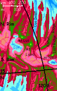
Next day, you spot Lake Geh to the north, and the grass is continuous and a healthy lavender. On the horizon is Mt Noba where we began. The Rift is too wide for you to cross here, 160 km or more (over 100 mi), but luckily, there is such a bridge 2-3 days west--a green ridge traverses the Rift above Lake Rafa, leading to the northeast side.
You don't have to take it. You can just ride the East Rim of the Rift due west as it turns into the South Rim of the dry, rugged Northeast Arch.
If you do cross to Mt Liava on the North Rim, you have many flyways:
World Dream Bank homepage - Art gallery - New stuff - Introductory sampler, best dreams, best art - On dreamwork - Books
Indexes: Subject - Author - Date - Names - Places - Art media/styles
Titles: A - B - C - D - E - F - G - H - IJ - KL - M - NO - PQ - R - Sa-Sk - Sl-Sz - T - UV - WXYZ
Email: wdreamb@yahoo.com - Catalog of art, books, CDs - Behind the Curtain: FAQs, bio, site map - Kindred sites