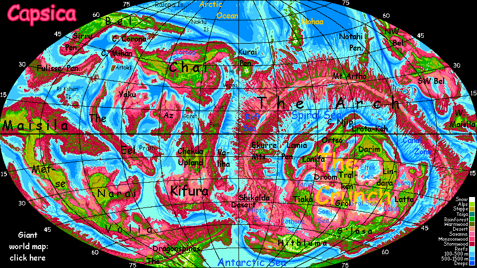
Capsica's homepage, map, giant ref map, geography, gazetteer . More worlds? Planetocopia!
 Capsica: The Arch: North Coast
by Chris Wayan, 2016
Outline only! Under construction!
Capsica: The Arch: North Coast
by Chris Wayan, 2016
Outline only! Under construction!
The Northern Arch: Introduction - Northwest - Southwest - East
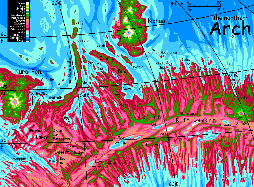
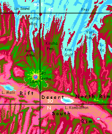
The Arch is a crustal spreading zone like Earth's mid-ocean rifts. But Capsica's shallow seas don't hide this huge structure underwater--or not much of it. The rift has two ridges flanking it, where the crust upwells; these wander, parallel, like the rails of a gigantic train track. The rift between is hot, arid--cut off from rain by the flanking ridges.
This north slope of the Arch gets winter storms--not blizzards of course, as on Earth at high latitudes, but rain. It's hot enough for rhodophores to flourish in the lowlands; in the cooler highlands, the predominant color is green. The lowlands, wet or dry, summer or winter, are warm even by Capsican standards, and fatal to Terrans much of the year--35-45°C (95-113°F) in winter and up to 65°C (149°F) in summer. They'd be hotter yet if they weren't so humid; clouds often cover the coasts. But inland, where it's drier, it really heats up.
Rule of thumb in the Arch: if it's green, you'll find it hot but survivable. Red? Not.
Dozens of ridges and sounds radiate from the rift at right angles; these are fracture zones, where the plate, spreading at different rates in different sections, grinds and slips. Such fractures dominate the region, defining the coastline, deciding where rain will fall (and won't), where most of the population lives, creating long updraft-corridors the locals use for flyways, and, incidentally, creating cooler highlands that Earth tourists can bear in winter, largely determining our tour routes.
The other prominent landform you'll notice right off: huge shield volcanoes rise here, up to 14 km high (46,000'). In Capsica's low gravity, that's not shocking. Even on Earth, Mauna Kea is 10 km tall (33,000'), though much of that is hidden undersea. Most giants of this type are in chains created as a spreading plate moves over a deeper hot spot: the Kurai Peninsula (upper left) and the Nohaa chain (top) are good examples. But there are exceptions--Mt Artho, in the east, is a solitary giant 10 km high. Without snow marking the highest peaks, it's hard to realize how rugged this region is; little Mt Isai, a stratovolcano barely showing up in the center, is 5.5 km high (18,000')--not much short of Kilimanjaro.
The prevailing winds here, especially on the coast, are usually from the west. So I think we'll start from Dorlin Strait, gateway to Kurai Peninsula on Chai. In early winter, storms start rolling in off the northern sea, drenching and cooling the heights to quite Terran temperatures. I'll offer you two flyways east: a coastal route up through the cape-and-sound country of the northwest, or a desert-hopping route through the southwest. Both inevitably meet on the North Rim of the great rift; it's the only safe flyway for tourists through the eastern, inland half of our journey.
Northern Arch: Intro - Northwest - Southwest - East
We start atop the Dorlin Hills, looking over the strait to Kurai. Mt Kurai, 14 km high (46,000'), the world's most massive mountain, is just visible as a broad line of white at the horizon. You'd mistake it for a cloudbank, but its sharp edge and stillness betray its solidity--that's ice up in the stratosphere. Capsica's curvature and Kurai's gentle slopes--it's a shield volcano--make it hard to see as a mountain. Unless you're on it, but that's another tour.
Below you, white red and yellow sails spangle Dorlin Strait like lost bits of bright confetti. Sailing ships (all of them cargo, of course; no one travels by sea; too slow when you can fly). One-eighth of Capsica's shipping passes through this strait; there are only two other entrances to the Arctic Ocean, the world's largest.
Prevailing winds are from the west here; they hit the Dorlin Hills and rise; you get free lift for your rented wings. You soar northeast along green ridges, looking down at olive slopes where red and green trees mix, and red to plum-purple shorelines where frost-intolerant rhodophores dominate. The coast is densely populated, though as usual on these tours, you'll need to camp here in the heights where the locals don't go much in winter--too cold for them. For once, a comfortable tour! Not a day over 35°C (95°F) and most barely 30C (86F). Nordic by Capsican standards.
We follow the Thul Hills for more than a week as you build up endurance; at first just a couple of hours in flight, but I'm aiming for six or more. At 50 km/hr (30 mph) it adds up; and it needs to, for the North Arch, mere segment though it is, is continental; we'll be traveling over 5000 km (3000 mi). Lewis and Clark on wings!
Capes and sounds; this isn't a simple coast. At first, valleys inland look drier, paler, lavender to pink: the colors of rhodophore grasses. But by the third day, inland looks redder, rainier, and on the fifth, a silver glint in the southeast hints of sea: Egg Bay, the head of Volu Gulf. You're now on Thul Peninsula, curving north into the polar sea for 1600 km (1000 mi), and never more than 160 wide (100 mi). On Earth it'd be an island arc. The next few days are monotonous--green ridgetops and volcanic cones 1.5-2 km high, red and purple coastal strips, blue and silver sea... that draws slowly closer.
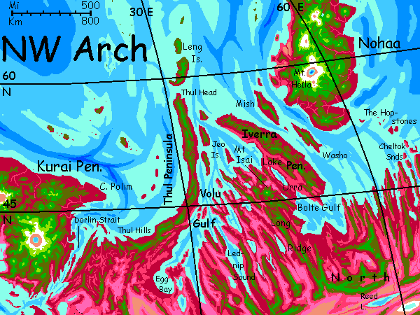
On day eight, we leave Thul. The hills run on north, dwindling, for at least a thousand km, first as a narrow cape, then the Leng Islands. But the island chain dead-ends in the Arctic Ocean at 67° north; you'd be comfortable even there, but days are short now in midwinter and there's little to see; locals don't live up there. Punishingly cold for them--it's 20°C (68°F). The hills actually see frost!
So you wheel right--east. You cross Volu Gulf here, near its mouth, by island-hopping through the Jeos. The straits are just 30-50 km (20-30 mi), though the effective width for you is more; you need to reach an island's central hills to land, camp and recover, it's 5-10° cooler up there.
Two islands and three hops later, you reach the far shore--the cool green Iverra Peninsula. In summer, hordes of natives follow your route, heading on north to the mini-continent of Nohaa and the Arctic Flyway. But not in winter.
Sadly, I can't let you avoid the heat indefinitely. These capes and islands--fracture zones extending from the rift that built the Arch--get lower and shorter to the east, trailing off into the Arctic Ocean farther south (and thus doubly hotter). So we must head inland and southeast to the high ridgetops of the Rift itself; let altitude compensate for lost latitude.
But we can't head directly southeast--Bolte Gulfe lies in the way; locals routinely fly across its mouth, but you can't, not safely. 200 km of open water (and another 100 of steambath lowlands you wouldn't want to land in) seems a bit much for amateurs.
So we head southwest over Urra Valley. Rich lavender fields and ruby orchards round leaf-shaped Lake Urra; fertile and populous country! But even now in winter it's over 40°C down there (104°F)--and muggy. Don't. If you're exhausted we can land in the modest hills south of the lake, but the best course is to push on to the much cooler slopes of Mt Isai, that giant striped cone looming ahead--maroon at the base, then olive, green, chartreuse, gray, and, now, in winter, a few streaks of white near the summit. Isai is the highest peak in the northwest Arch--5.5 km (18,000'). Almost Kilimanjaro (though wetter).
You can really relax on Isai! Swing round the peak until you're on the windward side. Updrafts lift you as high as you want--as cool as you need. Camp as long as you like, pick the fruit, fish in the streams. No one minds; no sane Capsican stays up here in winter. Bone-chilling cold for them. Snow burns, you know.
A few days later, rested up, you head southeast, riding the updrafts atop Long Ridge, a range 1350 km long (850 mi), and 3.5-4 km high (c.12,000'). Green, cool in winter, warm in summer, never really hot except at the south end. It's the safest flyway for tourists traversing the Northwest. All these lands at its feet are fertile and populous, but too muggy to visit comfortably.
A week at least of gliding down this long flyway. You'll meet local travelers--this may be high and cold for Capsicans, but a free thousand-mile ride is worth a few shivers. For them. Not for you. You're heading south; 35-degree days (95°F) get steadily more common. Get used to them. You'll need to for the eastern half.
At last, the ridge rises to 4.3 km (14,000') and... vanishes. Before you is a gigantic, hazy abyss. Tans, browns; a few lost-looking pink threads--creeks and washes. The Rift. You can't even see the far side from here, it's lost in haze, 320 km off (200 mi); just lesser ridges inside the rift. You're on the North Rim.
Here you meet some tanned, skinny, leathery aliens with condor wings. Then they strip them off. Oh. Terran tourists--the ones who took the Southwest route. Looks like it wasn't easy.
Northern Arch: Intro - Northwest - Southwest - East
An alternate route from Dorlin Strait east is to head south along the coast a day or two, then inland, skirting the Mirua Lakes. A rich region, but like the Urra Valley, you can't explore it up close. The lakes are just silver gleams on the horizon; the lowlands, great pink savannas with winding red veins, dotted with villages and ruby gardens. All from afar.
Even 3-4 km up, you're too low, at too low an angle, to see the deep strangeness of this region--a sort of grid of ridges, cupping lakes, some of them unable to drain to the sea. It looks artificial, like a truck tire big as Arkansas ground its tread into the landscape. But oceanographers will recognize it; common all over the flanks of the Mid-Atlantic Ridge! The ridges running out from the Rift are fracture zones where crust spreading at slightly different speeds meets and grinds; the ridges at right angles, paralleling Dorlin Strait and Thul Hills, are corrugations as the spreading crust faces heavy resistance and crumples.
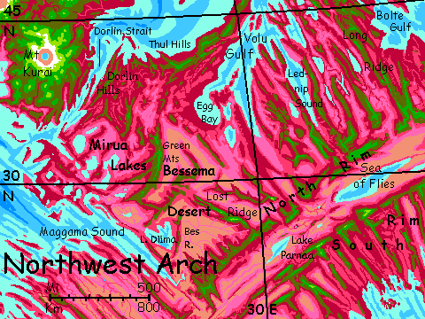
The Mirua basins--plural--are less fertile than the straighter ridges to the north. Less maritime climate, less rain. And lakes with no outlets tend to swell and shrink seasonally, and get brackish. No woods on their shores! And few large rivers; even where farms flourish, produce is hard to ship out. Not a cursed land, exactly--we'll see much worse inland, in the Rift--but poorer than you'd expect.
You'll have to leave the highlands now and then, hop across to other ranges; they're not continuous here in the slip zones. Spiral up, get what altitude you can, and glide across these hot dry savanna-valleys to the next range, spiral and rise again. One a day--for days.
Eventually, we'll reach an easier road: the haven of the Green Mountains. Vague name? Not on Capsica. It means mountains high enough to rise out of the rhodophore zone entirely. At this latitude--and we're down to 35° north, not the forties and fifties of the northwest tour--it takes heights over 3 km (10,000'); and in fact the Greens top out at nearly 4.5 (15,000'). Quite snowless, of course, even now in winter. But temperatures ideal for Terrans--though only along a path a few km wide.
Views get longer, especially to the east; mostly cloudless there, for those browns and tans with no hint of rhodophore red or chlorophore green imply desert--the Bessema Desert, big as Texas, and much hotter. Without the Green Range this flyway'd be rough even for locals, and fatal for you.
After a couple of days due south, the range ahead seems a bit lower and scruffier. Wait for midmorning, once the air-columns are really rising. Spiral up as high as you can; we're peeling away from the Greens and cutting across the desert some 200 km (125 mi); a long hard day.
Our camp is in an open wood of mixed red and green xerophilic trees on the highest desert peak we could find--just 2700m (9,000). Water's scarce here. More a sky-reef than a sky-island. Not quite high enough.
Hot night.
East along this sky-reef for half a day; over a shorter, brushy gap, in the afternoon, to land exhausted in green woods on the shoulder of a high, narrow keel or prow: the dramatic eastern tip of Lost Ridge, a lonely range a good 360 km long (230 mi) and 3.5-4 km high (c.12,000'), spearing through the heart of the Bessema Desert. It's the easiest flyway across the desert and the only one tourists can handle at all. Water high on the ridge is sparse some nights, but don't descend seeking larger streams; only the green-wooded ridgetop is bearable for Terrans.
I'm translating the name, of course; it's from a legend of a lost goldmine. Do NOT search for it. All the tales have it down in the death zone.
Days down this narrow but safe path, with desert on both sides. Not identical, though. Brown valleys to the north, but a much wider plain to the southwest, with great pink veins where creeks from Lost Ridge meander, fusing into a reddish line on the horizon: the Bes River. A mini-Nile, this shallow, tree-lined stream is about the only one in the Southwest to make it to the sea--admittedly, just barely. It enters at the head of long Maggama Sound, 1000 miles from the open ocean. Maggama's a fracture zone, where two stretches of Rift spreading at different speeds have split apart. And they call it the Arch for a reason! The Rift curves, and on the convex side, new crust tends to split, unable to stretch to fit; you find more gulfs, like Volu, Maggama and Bolte. The inner curve tends to crowd; fewer deep sounds, more washboard ridges.
Another day or two, to the end of Lost Ridge, a great jagged wall rises ahead. A clear junction: the North Rim. Over the wall, the world just ends: the Rift, 4-5 km deep (13-16,000'); a spreading zone like that of East Africa, but more vigorous--and, in Capsica's lower gravity, less constrained.
The result is harsh. The flanking rims cut off rain down there, and also guarantee that most streams can't reach the sea. Salt and alkali lakes, like Lake Parnaa beneath us, a garish yellow and pink swirl crusted with white around the shore. Salts build up in flats and sinks; winds spread irritant dust. Few plants can take it; the flats are bare.
The Bessema Desert behind you seems friendly now.
To the right, down the Rim toward the equator, is the Western Arch: another tour.
Here we turn northwest. The country is rugged, but the North Rim is so high and cool it has some rain, some trees. The desert below generates oven-heat; but that means stronger updrafts too. With care and planning we can ride those updrafts northeast.
For all next day, the ridge is continuous; easy, if you ignore the glare and the desiccating winds and that alkaline tang that says deep desert. A short gap, just ten miles or so, near sundown; the cliffs ahead glow in the setting sun, guaranteeing updrafts... so we make the hop now, and get lifted back to forest heights.
Next day, a good solid chunk of highland, but a longer gap near dusk. Tiring. These gaps are fracture zones; minor ones like these, mere Grand Canyons, occur every hundred miles or less.
It's the big ones I worry about.
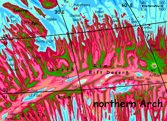
A long stretch, two days now, with small gaps but parallel, thinly wooded ridges, always with creeks and waterholes. So far. Far below, in that heat-shimmering other world, is what seems to be a sea. White salt flats, then silver to the horizon--no far shore even visible. It's the Sea of Flies, some 800 km long and up to 160 wide (500 by 100 mi), many times the size of our Dead Sea. It varies in size seasonally (and year to year). Saltmarshy shores. Little rain; if it weren't fed by Reed River at its east end, still far out of sight, it wouldn't exist. A nearly unpopulated region. Consider the name, and guess why.
Discouraged? I sympathize. But we don't have far to go, now, to meet with the northern flyway. A couple of days--and the North Rim stays high and green. Hot, but not unbearable. If you're really sick of this and want out, there's an escape hatch: two ridges heading northwest back into fertile lands around Lednip Sound--the longest finger of Volu Gulf, reaching closer to the Rift than any other. Two days of ridge running above less toxic desert and savanna, and you're back in the north.
But one more day, and you curve north a bit as the Rim retreats--not quite a side canyon, more of a cove. Sheer drops a mile or two here. Good updrafts as a result. Dance around the rim of this fire-ring...
Near sunset, a cloud of tired, droopy flies ride thermals out of the northwest. No, sparrows; no, crows; buzzards; condors; pterodactyls. Oh. The tired travelers who took the coastal route. Your flyways have merged at last.
From here on, we're in it together.
By late winter--just weeks now--I think you'll survive to reach the cool green shoulders of Mt Artho--tour's end. Or if I miscalculate, you'll have reached an earlier, different sort of end.
Northern Arch: Intro - Northwest - Southwest - East
You're on the North Rim, looking down a cliff-cove at dawn. Blue and dim down there, but soon it'll be heating up. Take your time at breakfast; wait for the updrafts to really get cooking. And then launch off the cliff, with over a mile of abyss beneath you, and get soaring. Another day on the Rift.
And another, and another. This first third of our leg, 640 km (400 mi) is a fairly straight flight along the North Rim, logistically much simpler than the previous legs of the tour. Hot, but amazing scenery. Almost like hang-gliding over Mariner Canyon on Mars. Slopes in places, cliffs in others; always at least a 3-km drop to the rift floor--the lower gravity allows a deeper gash and higher rims than, say, our East African Rift.
On the third day, Reed Lake fills the valley below us. Unlike the Sea of Flies, a hazy, far-off glare of silver, Reed is right below us--the Rift here forks slightly; a central ridge a couple of km high (nearly 7000') walls off the farther half and narrows this one. Locals often cross the Rift here; they don't mind the heat (even now in winter, a good 45°C (113°F)--the floor is low desert, and the cliffs reflect heat). It's not only right below us, it's blue and green--healthy. Its name is obvious. Reeds abound in the shallow waters. There's a reason: Reed has an outlet! A creek flows down to the Sea of Flies. So the shoreline's quite stable, and salts don't build up; the water's fresh. There are ruby trees down there--a thin red outline round the turquoise jewel, but still. None of the other lakes have had them. Too much salt.
No wonder locals cross here--the most popular Rift crossing for 2-3000 km east or west! But you can't enjoy the lake's shade and swimming (and fruit and fish) like the locals. Just perch high on the wall and peer in.
Another day east, two miles above the shores of Lake Reed. The lake's still going strong (it's 300 km long--over 180 mi) when, at sunset, we reach our first true gap in the great wall. Sleep on it. We'll tackle it in the morning.
Midmorning, to be exact. Once the east-facing cliffs have really heated up. You spiral high, taking an hour or two, till you top out at 6 km up. You can still breathe up there! This isn't Earth; the pressure drops off slowly. You might not fly very well in the thinning air, but the updrafts are still strong enough for an equlibrium. You bob like a hailstone in a thunderhead.
Only not. Sorry. Poor simile for Capsica. Even up here--20,000', in winter--you're warm.
And you stay so. Hard exercise! You can't just soar east; as you leave the rimwall, the updrafts get spotty and fail. Flap, glide, flap, glide--for hours. The gap's 145 km wide (90 mi).
Halfway, a red snake winds across the side-valley floor; a tributary of Reed Lake. Rare to see more than short creeks entering; the predominant tilt is away from the Rift. But this one's substantial; a river, really.
On to the far side. Exhausting. That's what all that altitude was for; you can glide the last 20 km and still reach the eastern cliffs waist-high. Of course that means a mile of red and black basalt frowns down on you. No shade even if you could land on a ledge and cling; few trees. By now the sun has shifted, and the shines full on this side of the gap.
But that's not the catastrophe I'm making it out to be; I planned it. Full sun on stone: perfect! The updrafts have shifted to this side of the valley. They loft you up to the rim. Trees, shade. Campground. Wells. Water.
Sleep twelve hours.
This eastern rampart is the jumping-off point (literally, I mean) for tourists trying to cross the Rift. Reed Lake's narrow head is some miles out; little red threads of creeks converge on a stream feeding the head of the lake. But beyond, faint in the haze, is a great brown keel, green-topped, part of that central ridge from 100 km back; but here it's as close as it ever gets, 110 km out (70 mi). Tourists can camp there in shade, and a second, similar crossing, though uglier--the far basin's a salt-poisoned horror--it's narrow enough to cross in an afternoon. You can reach the South Rim without ever dipping below 2.5 km (8000'), never in the red zone. Far cooler than the Rift. The only route practical for tourists.
Let's not and say we did. Crossing that side-valley was achy work enough. And I have my reasons to stick to the North Rim. One of them ten kilometers tall.
East for a week. Even at our leisurely gliding pace, it adds up--over 1000 km, 6-700 mi. This chunk of the Rim meanders a bit, but for the first four days it stayed high, close to 4 km (13,000'). Water and shade aren't problems. I said I prefer the North Rim, and this is one advantage: the sun shines full on it; updrafts are steady. The South gets some sun, early and late, but updrafts are patchy; just as many invisible sinks. The whole northern Rift can get into a pattern like a spinning tube or slow-motion sideways tornado--downdrafts on the shady south cliffs, winds blowing north over the floor, up the hot north cliffs, and back south at higher altitude. Strongest on summer days, but even now...
The last two days, the Rim sagged a bit, down to 3 km (10,000'); a bit less, rim to floor. The ridge is narrower too; behind, to the north, instead of plateau or mostly high basin-and-range country, low savanna plains sprawl lavender to the cloudy horizon. This land gets more rain! A fracture zone not quite deep enough for a gulf has left only low hills all the way to the sea; storms roll farther inland. You've noticed the green (and a few brave red) trees look a bit denser on the rim, too. Even down in the rift, streaks of pink; dry rhodophore grass.
Next day, a high green plateau stretches north: a fracture ridge. A flyway to the north coast. But let's stick with the rim a little longer.
If it sticks with us. Next day it narrows and, twenty miles later, just ends, a prow dropping into air. Ahead, just abyss. To the left, a gap of ten or twenty km, then the rim resumes. Not a hard flight for you, by now. But the first gap in over a thousand kilometers.
At noon the next day, you spiral higher, until you can see the whole segment: a true sky-island, green above dun. Perhaps 20 km wide and 100 long. Yes, it too ends. You reach the gap late in the day--not too wide, an hour perhaps? You cross now, while the west-facing cliffs get a final blowtorch from the setting sun; free loft, back into the green.
You camp tired. Will it be all gaps, now?
The Rim stretches east all day. It climbs a bit, nearing 4 km high now (13,000'), and sheer cliffs half that height. But by now, the most spectacular views are routine to you; gliding through monotony. Camp, sleep, do it again... and midmorning, without warning, the world ends. This is no mere side valley--the Rim kinks retreats sharply to your left to the horizon. In front of you, just low desert to the horizon.
Two choices here!
And because it's a port, yet downriver from a nation-sized volcano, the town exports produce from many ecozones. Traders come from all over.
Native tourists do too; but they may be outnumbered by spiritual pilgrims. Hard to say; lots of overlap. Anyway, the peak is holy as well as spectacular.
All in all, Port Artho's a cosmopolitan town. One of your few opportunities to see a Capsican city safely. I'd go.
Not hard, just longer--head north two days, then east a day, then zigzag through the hills a couple more, camping on ridgetops, asking in the valleys...
Good thing you have a guide. Far to the northwest is a green-topped mesa, well below you but still high enough to be livable.
Sleep. Rest up. This gap is big; nearly 100 km (60 mi). It takes all day to spiral up, dash across, spiral up again, land, set up camp, and... collapse.
Next day: mostly rest. An easy soar of an hour, 50 km, to the east end of this mesa. From here you can see the far rim now at least; but this gap's 160 kilometers--100 miles in the dry heat.
Sleep, eat, hydrate, stretch. From takeoff you'll get no rest. Nowhere to perch. This gap, your last, and (I promise) the widest, takes all your hard-honed endurance.
But on the far side, you land exhausted on the knees of a ten-kilometer mountain--Mount Artho, 33,000' tall.
Next, just climb it. Or, of course, click to the top.
World Dream Bank homepage - Art gallery - New stuff - Introductory sampler, best dreams, best art - On dreamwork - Books
Indexes: Subject - Author - Date - Names - Places - Art media/styles
Titles: A - B - C - D - E - F - G - H - IJ - KL - M - NO - PQ - R - Sa-Sk - Sl-Sz - T - UV - WXYZ
Email: wdreamb@yahoo.com - Catalog of art, books, CDs - Behind the Curtain: FAQs, bio, site map - Kindred sites