Capsica's homepage, map, giant ref map, geography, gazetteer . More worlds? Planetocopia!
 Capsica: Northwest Bel
by Chris Wayan, 2016
This one's for AE and his planet-building ape
Capsica: Northwest Bel
by Chris Wayan, 2016
This one's for AE and his planet-building ape
Introduction - North - West - Southwest - Southeast & North Again
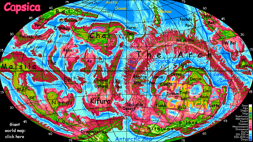
Bel is about as big as South America. It's the second largest landmass on Capsica, though not by much--Chai and Kifura are nearly as large. Bel's the coldest continent on average; much of it's subarctic, and Eastern and central Bel have extensive highlands, further cooling the climate. That's good for Terran tourists; you can travel freely all over the north, and in winter you can even explore much of the south.
Unlike Chai and Kifura, several separate tours will be required to explore Bel fully; it's a spidery, amoeboid place, and its lobes are very different. Like Siberia, Bel as a whole spans nearly half the planet! It's hard even to photograph from space; bits trail off into night, or over the horizon, or are lost in sun-glare.
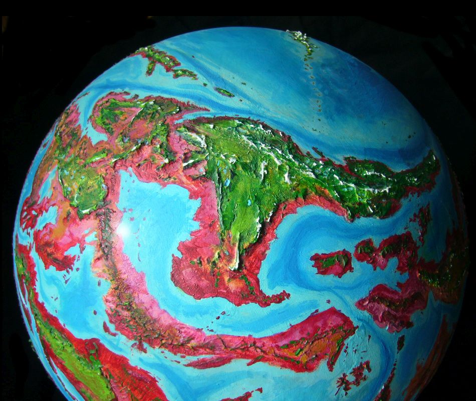
This tour explores the ridge-maze of Northwest Bel. There's a long tour looping through east, north and central Bel. To the southeast is long, low, hot Fulisse Peninsula. The tour of hot arid Southwest Bel is still pretty skeletal--there just aren't many parts of it you can visit! Wester Bel lies on the very edge of my master world-map, so building less-distorted regional maps for western Bel has been slow work, and the maps you see are less accurate than for most regions.
Introduction - North - North - West - Southwest - Southeast & North Again
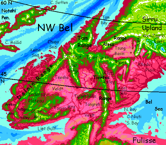
We'll start at the edge of the Sirru Highland in northern Bel. Right at the western rim, Sirru breaks up into rugged snowy fingers--the Aissa Range groping west, some 8 km high (26,000'), and the stubbier Trosh Range reaching southwest, topping out at a mere 7 km (23,000'). Both ranges are a good six km (20,000') above the hot dry basins at their toes. Earth has few mountains this tall head-to-foot--Nanga Parbat, Dhaulagiri, Denali, Santa Marta--but in Capsica's lower gravity and sealevels, such giants are both more common and more exposed.
These huge ridges generate updrafts the natives can ride west into Northwest Bel, but beware--the ridgetops are too high for tourist fliers like you. You won't black out, but you can't get enough lift. Nor can you swoop to their feet; that's deep in the hot red zone, even though it doesn't look red--too dry for much vegetation of any hue. The Tsung Basin is a hazy dun barely blushed with pink; it could almost be the Taklamakan, or Death Valley.
So what you need to do is tricky: steer along the Aissa Front waist-high, between the crash and the oven zones, for a long day or two, to Wooded Pass, just over 3 km high (2 mi) between the Tsung Basin and the cool rainy lowlands of Tam Bay. Ahead of you is an opportunity you rarely get on Capsica: to explore a Capsican port city. It's winter, and the head of the bay's 55° north. It's a frosty 30°C (86°F) down in Port Tam, and not as humid as most of Bel's north coast--Tam Bay is long and mountain-flanked, blocking all but the strongest storms. You can actually visit!
You sweep down the slope from the pass like a diving pelican, and in two hours you've gone from what felt like Central Asia to what could be a quaint Nordic seaport--though of course most of the foliage is red and purple. Port Tam's right at the head of Tam Bay, a sound 600 km long (375 mi). It's the biggest city for 2-3000 km in any direction. Eventually we'll have sketches here, but for now you'll have to speculate on what the town and the locals look like, exactly. All I'm sure of is, most will be smallish and lightly built, with angel-wings. The gravity's light and the air's dense; Darwin's practically begging them to fly.
Oh, and they look overdressed for the heat. That's not pomposity--at lesat not mostly. It's cold to them.
Fun while it lasts. But after a day or two, the cold snap fades and Port Tam thaws back to a more normal winter chill--35°C (95°F). Time to head for the hills of Tam Peninsula and stick to the cooler highlands. As you'll be doing a lot on this tour...
The Tam and Dalnin Ranges form a tangle of ridges, valleys and plateaus called the Zas Knot, rather like the Pamir Knot on Earth. Not quite as high; the Tam Range tops out at 5.2 km (17,000'), but the Dalnin, two day's soar to the southwest, reach 6 km (20,000'). The plateaus and gorges between get storms off the sea year-round, so rainy, lush forests cover most of it--red and purple near-pines in the gorges, but silvergreen near-aspens on the heights. We're far enough north still that the only signs of locals are farmsteads on wide bends down in the sheltered gorges; the uplands woods are cold dark and miserable in local eyes, and the few open ridgetop meadows are windy and even colder. In short, ideal for Terrans! Strip down in the day, a sleeping bag at night, and you're fine. Plenty of pseudo-mosquitoes, but your body's so cold you fool their heat-seeking sense! To most Capsican parasites, you're a living stealth plane. (On the other hand, some decay organisms assume you're The Walking Dead, so be aggressive if anything itches. On any world, flesh-eating bacteria are no fun.)
West to the Dalnin Range, a T-shaped collision (or collusion) between forces. The well-understood force is continental drift--the Dalnins proper parallel the trench offshore; subduction's jamming the Notahi Platelet under them. It's no wonder they rival the Andes in height--similar forces! But the Dalnins have a long spur southeast, nearly as high, at right angles to the main coastal range. Seems as inexplicable as the jumbled east-west ranges in northern Argentina, or Utah's east-west Uinta Range, or the Mogollon in Arizona. I can only guess the Zas Spur is something like the long straight ridges of the fracture zones in the Arch (or Earth's equivalents, our undersea rifts)--a seam between bits of crust creeping at somewhat different paces, though in the same direction. Or the whole continent corrugates here under pressure--this end of Bel shatters into at least three platelets that on Earth would be mere island arcs, but on drier Capsica, they're high and dry. Whatever the cause, the locals use the Zas Front and the updrafts it creates as an easy flyway around the otherwise flat savannas of the interior; this arc will loft you halfway to Fulisse.
We'll get there. But we have the west to see first.
Introduction - North - West - Southwest - Southeast & North Again
For a week you sail southwest down the Dalnin Mountains. On the coastal side, far below you see lush red plains and low hills rolling to a band of silver on the horizon--Chupa Sound, and the next day, more distant, the arms of Keina Sound. Just over the horizon, floating in haze, are coastal hills up to 1500m high (5000'). It's almost California, with a flooded Central Valley. (Sorry future readers; I know for you "flooded Central Valley" is redundant. But in my age the Valley was hot dry and dreary. You didn't miss a thing.)
Look left. Inland from the Dalnin Crest, you see only a vast flat smear of pastel color. Pink and lilac grasslands sprawl to the horizon--and hundreds of kilometers beyond. The Tsesha Veldt, heart of this subcontinent. I'd compare it to India's Deccan, but that's weak. Lowland not high, an alluvial basin not a basalt lava plain... really, the only similarities are inland, dry, and hot.
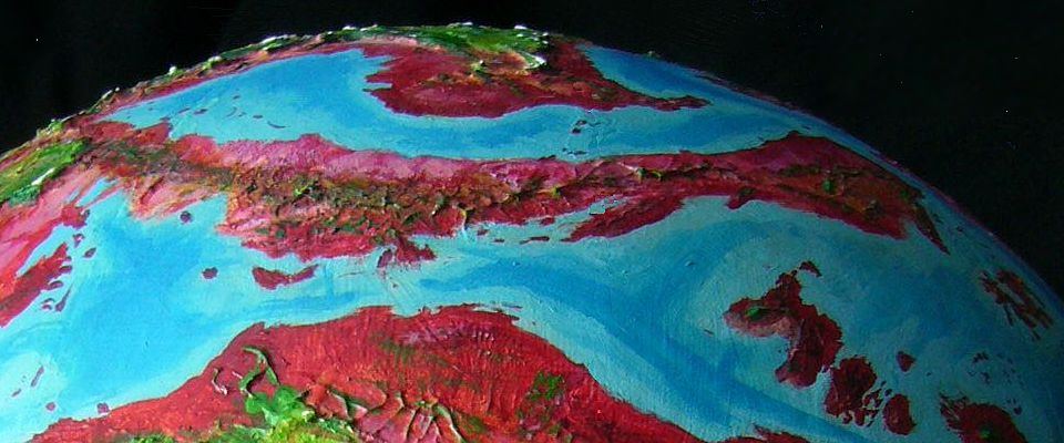
At last the great range starts to curve south. On Earth, it'd be an island arc. Here on drier Capsica it's a curving wall of volcanoes nearly 1000 km long (c.600 mi), called the Arekse Range. But the Arekses aren't a simple, single volcanic arc of the kind common on both Capsica and Earth, but several broken, roughly parallel sub-arcs. Rather than slipping meekly under, the oceanic plate seems to have fought back, fracturing the continental one. The nearest parallels I can find on Earth are the Mentawai Islands off Sumatra and Java (and that's a simple, straight double wall) or, better, the Mariana region in the Pacific--multiple arcs, but so deep-drowned it's hard to compare.
The coastal ranges and lowlands get plenty of rain and are wooded--red foothills, olive heights. The highest arc, inland, is the one you follow--peaks top out at 3.5-4.5 km high (12-15,000'). These, the Arekse Crest, have green forests and meadows, with temperatures bearable to Terrans most of the year and now, in winter, quite mild.
Looking inland, you see wide, olive-colored, wooded plateaus that slump invisibly, far over the horizon, down to Tsesha Veldt. This plateau-complex, called the Indersa, forms a sky island bigger than Taiwan, but a bit too low to be pleasant for Terrans even now in winter. Survivable, but for us it'd be an uncomfortable shortcut. Stick to volcano-hopping. Safer. The chain leads you...
Introduction - North - West - Southwest - Southeast & North Again
The Arekse complex's fragmentary mountain arcs grow lower and more broken as you head southwest. Best to stick to the main, highest inland arc; the coolest.
On the third day, the Arekse Range fails. Low, hot hills. Here a great river, the Ndigna, breaks through the coastal range to reach the sea. It's strong enough to do this because even in this Southwestern climate, with a Californian summer drought, its flow is substantial year-round; the Ndigna River has arms stretching far up into the central Dalnin Range, days behind you to the north; no snowmelt, but it's cooler, rainier country, with no dry season. So the Ndigna's cut quite a canyon.
South of this stiflingly hot gap, the southern Arekse Range is lower, but still a lot better than nothing.
Relief! We reach the Glerr Highlands, a knot of mountains north of Liet Gulf. Valleys 2.5-3 km up (8-10,000') and peaks up to 4.5 (15,000'). Olive wooded valleys, green-wooded heights, some opening into meadows. Now, in winter, mild rains each few days, then sunny and warm. In summer that sun's relentless--a Mediterranean dry season, just one topping 50°C (122°F) up here and 60-70 in the densely settled lowlands.) But now, in midwinter, quite bearable for Terrans. Explore a few days. Scenic.
East along the Torien Range, the southernmost lobe of the Glerr Highlands, 3.6 km high (12,000'). Ruby forest below you on the coast side (to the south), green around you on the heights, lilac savanna inland. Cloud-capped; the Toriens may not be high enough for snow but they snag clouds and rain just fine.
A grueling two days. You must cross the broadest lowland gap on this tour--from the Toriens to the Tipseh Hills in the heart of Southwest Bel. The Hills are modest next to the jagged ranges around them, but still reach 2.8 km high in spots (9,000')--lofty enough to be quite bearable. But between the Toriens and the Hills sprawls the lower Tsesha River's floodplain. Hills do crop up, but nothing over a mile (1600m); it's going to be a hot, miserable couple of nights.
East along the Tipseh Hills to the Tiertsa Range, a long, straight, steep, jagged mountain wall up to 5 km high (16,500'). It's more scenic and more hospitable for Terrans than anything in weeks. No snow, but day temperatures of just 25-30°C (77-86°F) and even cooler at night. You sleep well.
The Tiertsas aren't just a tourist favorite; locals like them too, though not for the near-Arctic cold. Prevailing winds hit the ridge full-on and are forced up; ridable updrafts make Tiertsa a north-south flyway over 2000 km long. We won't mingle much, of course; they hug the foothills, where it's cool but bearable, in the low 40s (104-113°F). We'll have to stick to the heights.
Two miles below you, the locals look like a stream of migrating songbirds; in this big landscape it's hard to see that those little fliers are many times bigger than any on Earth since the pterosaurs.
Sigh! The Capsicans always seem elusive, don't they? But that's what a body-temperature difference of 25-30°C will do; you share the same physical world but your experiential worlds rarely and barely meet.
Two miles is close.
The southern end of the Tiertsa Range is the gateway to two more subcontinents:
Still, it's navigable for tourists, due to a mountainous spine where Earth travelers will be uncomfortably warm, but alive. So at least a skeletal tour's now in place...
Southwest Bel. Looking south--equator roughly on horizon |
The northern half is a plateau high enough to be tourable, but the southern half's low and furnace-hot. For Capsicans too, I mean.
Not much rain, either--it's at the latitude of the Sahara, and with high lands upwind that already squeezed most of the rain out. A sprawl of deserts, marshy lakes fed by the northern mountains (or they'd be dry pans) and savanna, with few mountain refuges for Terrans--or the locals, for that matter. Even Capsicans find these lowlands pleasant only on the coasts. Just too hot and dry.
That means the sky is crowded. You meet lots of locals.
Eventually, that will mean adventures, and portraits, and inhuman interest stories here...
...but this is a skeleton. I'm just trying to get you through alive.
Introduction - North - West - Southwest - Southeast and North Again
After a few easy days south along the Tiertsa Wall, a difficult day hopping east from Tiertsa's sky-island to a new one, Alosi, to the east. Below, meadows and orchards. It's no hotter, but it's more humid here; most rain now comes from the east, off the Bel Sea. It's still invisible, beyond the southern and easter horizon, even at this great height; but you can see its influence below. The valley bottoms are lavender to magenta now, not the pale pinks and dusty tans on the Tangreh Veldt back on the drier west side of Tiertsa Ridge. Continental Divide!
You reach Alosi Ridge with relief. A long day's flight with no rests--no perches above the oven-hot farms of the Alosi Valley. Peer over the rim to the east to see...
Very little. The new moisture means cloud-towers mount up the east face of the Alosi Range. Even when you you find a clear gap, the cerise and blood-red flatlands are half-hidden by a herd of fluffy white low-lying clouds.
You just can't go farther east, into those vast, fertile flats. Atledu Plain's the wealthiest region of Southwest Bel, but it's unbroken hot lowland--no high perches, no oases of cool. Fatal for you.
Our way lies north along the summit ridges of the Alosi Range, roughly paralleling the Tiertsas, but a day's flight to the east. It's not as easy; fumbling through clammy, steambath cloud, you get nostalgic for the austere but spacious west.
Two or three days later, the Alosis start to sag at last. But you continue north over a gap of sorts--olive-wooded hills still over 2 km high (7000'), hot but just bearable--shade trees everywhere and creeks to swim in. The east and its rains do have some advantages. To offsett that maddening humidity.
After a couple of sweaty days you reach the (relatively) cool, high Transverse Range. Only 30°C up here! 86°F. Relief.
If you flew northwest a couple of days you'd end up where we started, near the Aissa Pass and Port Tam.
But our way lies east along the Transverse Range, I think--for I want to end with...
A half-day flight across the low gap to the Trosh Range, a spectacular tongue of jagged peaks up to 7 km high (23,000'), dividing the fatally hot Tsung Basin and Atledu Plains. This bridge of bearable temperature is only a day or two long, and the flying's easy; updrafts all over. Trosh is just a spur of the Sirru Uplands, in the Eastern Bel tour. And Sirru, if you haven't explored it, is a hell of a lot more comfortable than this tour was.
Grand summation! Insert folksy wisdom undercutting postmodern pretension.
And then tearful farewells... if I live long enough to ever really write this tour.
World Dream Bank homepage - Art gallery - New stuff - Introductory sampler, best dreams, best art - On dreamwork - Books
Indexes: Subject - Author - Date - Names - Places - Art media/styles
Titles: A - B - C - D - E - F - G - H - IJ - KL - M - NO - PQ - R - Sa-Sk - Sl-Sz - T - UV - WXYZ
Email: wdreamb@yahoo.com - Catalog of art, books, CDs - Behind the Curtain: FAQs, bio, site map - Kindred sites