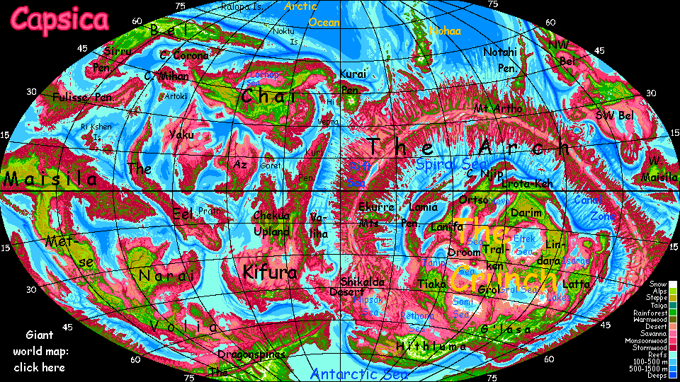
Capsica's homepage, map, giant ref map, geography, gazetteer . More worlds? Planetocopia!
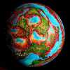 Capsica: Southwest Bel
by Chris Wayan, 2016
This one's for AE and his planet-building ape
Capsica: Southwest Bel
by Chris Wayan, 2016
This one's for AE and his planet-building ape
Introduction - North - West - South - East & North Again
Bel is about as big as South America. It's the second largest landmass on Capsica, though it has rivals--Chai and Kifura are nearly as large. Bel's the coldest continent on average; much of it's subarctic, and Eastern and central Bel have extensive highlands, further cooling the climate. That's good for Terran tourists; you can travel freely all over the north, and in winter you can even explore much of the south.
Unlike Chai and Kifura, several separate tours will be required to explore Bel fully; it's a spidery, amoeboid splotch, and its lobes are very different. Like Siberia, Bel as a whole spans nearly half the planet! It's hard even to photograph from space; bits trail off into night, or over the horizon, or are lost in sun-glare.
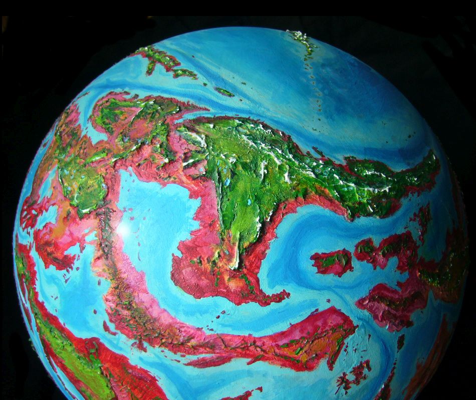
Bel's really not a continent at all in any geological sense; not a slab of lighter rock, nor a unified plate. It's a hodgepodge that just happens (as much of Capsica doesn't) to be fully surrounded by shallow seas. If Capsica were Earth, blessed (or cursed) with deep oceans, Bel's central and eastern uplands would be a smallish continent; the mountainous Northwest, an Indonesian maze of island arcs; the Fulisse Peninsula (southeast Bel) a mere Hawaiian chain; and the Southwest, a sort of Sumatra, mostly low plains but with mountains along the southern coast. Since the seas of Capsica are much lower/smaller, that Sumatra's a cool plateau above a broad skirt of southern lowlands, all furnace-hot. I mean, even for Capsicans.
Not much rain, either--the Southwest's at the latitude of the Sahara, and Bel's central highlands upwind already squeezed most of the rain out. A sprawl of deserts, marshy lakes fed by the northern mountains (or they'd be dry pans) and savanna, with few mountain refuges for Terrans--or the locals, for that matter. Even Capsicans find these lowlands pleasant only on the coasts. Just too hot and dry.
Introduction - North - West - South - East & North Again
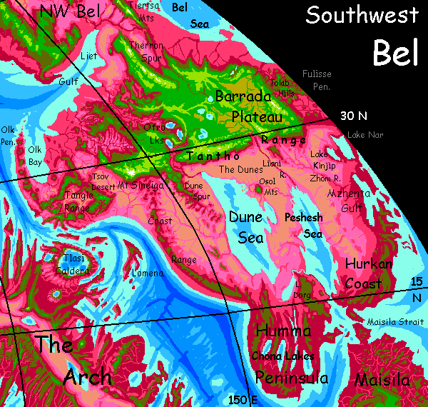
Northern and southern Bel divide naturally at a broad isthmus, over 600 km wide (400 mi). But both coasts of this neck, Liet Gulf and the Niuti Bays, are hot lowlands intolerable to Terrans even in winter. For us, there's only one narrow route in: the Tiertsa Range, up to 5 km high (16,500'). Interestingly, this narrow, jagged mountain wall is the overwhelming choice of natives, too, though not for its cooler weather but its flight characteristics. Tiertsa's wall stands squarely across the trade winds, and generates reliable updrafts for 1000 km or more. It's an easy flyway north or south.
We won't mingle much, of course; the natives hug the foothills, where it's cool but bearable, in the low 40s (104-113�F). We'll have to stick to the shoulders of the great wall, where it's ten or twenty degrees cooler--bone-chilling to the locals, warm for us. We could even go high enough to be cold ourselves: there are snow streaks on on the higher peaks, here in winter at least.
Two miles below you, the locals look like a stream of migrating songbirds; in this big landscape it's hard to see that those little fliers are many times bigger than any on Earth since the pterosaurs.
Sigh! The Capsicans always seem elusive, don't they? But that's what a body-temperature difference of 25-30�C will do; you share the same physical world but your experiential worlds rarely (and barely) meet.
Really, two miles is close.
100 km into southwest Bel, the Tiertsa Range starts to fail. Not entirely--Capsicans keep comfortably riding the half-size ridge south--but even now in winter, as the altitude of your camps creeps down below three km into the high twos (8-9000'), night temperatures rise to 30-35°C (c.90°F), and you start sleeping poorly. It's time to veer away.
At dawn you head west. Faint white teeth on the horizon are your goal: the Therron Spur. Though it's a near-twin to Tiertsa, and an excellent flyway as far as it goes, locals don't like it because after a few hundred km north, Therron's wall--and winds--abruptly fail. But we're heading south and we need height! Therron's peaks reach 4.8 km (15,800'). You may camp warm, but not sleepless-hot.
Southwest Bel. Looking south--equator roughly on horizon |
Two lazy days and 400 km later, you reach what Therron Spur spurs away from: the Barrada Plateau. This is the largest upland of southwest Bel; big as Borneo, some 1600 km east-west and over 600 north-south (1000 by 400 mi). Most of the Barrada is 3-4 km high (10-13,000'), though its south and east rim rise to 5.5 km (18,000'). Such peaks see snow in winter, but the plateau never does; we're down to thirty-odd degrees north now. The plateau's quite Terran; a patchwork of green woods and yellow savanna, with almost no rhodophores. The few Capsicans here are rugged antisocial types willing to shiver most of the year to escape the crowds of the rich lowlands around Liet Gulf and the Bel Sea...
Here's your chance to interact with Capsicans--at least the subset ornery enough to hole up here through these savage, Miami-like winters. Be sure to go into a bar and bet you can survive a ten-minute swim in one of Barrada's 'icy' highland lakes. The locals can't, and probably won't believe you can. Quite a few of these wild-west Capsicans are miners; these mountains have gemstones and rare metals. You need to travel light, of course, so I generally avoid mentioning arts, crafts or souvenirs; but a few gold nuggets or big star sapphires won't weigh you down. And if you show it off, the story of how you won it will probably get you free drinks in the next inn, and the next, for a few thousand kilometers. Though you'd better like mulled wine and hot sake; room-temperature Capsican drinks won't quite scald you, but no matter how hot the weather, don't expect a nice cold beer.
You take your time heading southwest over the plateau. You need to; flying up here's hard work. The air's thin, and most of my readers, unlike Capsicans, never evolved to fly. You're amateurs in your strap-on wings, and up here it shows. Still, you're Tibetan-high, but the air's not Tibetan-thin. Lower gravity means air's not held as tightly as on Earth; it thins out slower and was denser to start with. Still 1.6 atmospheres; enough in this low gravity to hold you up. With a lot of extra work, sigh...
The Ofro Lakes, lower than most of the plateau--just 2.5 km up (8000'). Olive hills, a mix of Earthlike greenwood and rhodophores. In summer, Capsicans actually do swim here; they vacation in the mountains to escape the summer heat. The beaches round these lower mountain lakes are a mild 55°C (131°F), not the 65-70 of the lowlands (149-158°F), with bracingly cool lakewater--35-40°C (95-104°F).
Now, of course, in winter, the basin's 20° cooler; the beaches are empty, the resorts mothballed for winter. No ski season here!
Introduction - North - West - South - East & North Again
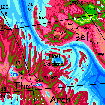
From the Ofro Lakes on west, Barrada is less a plateau than a broad, dissected massif, dropping off into deep dry canyons, especially on the south.
While I chose cloud-free orbital photos, they're composites from unusually clear days. The plateau pushes desert air so high it wears a crown of cumulus, especially around the edges. You're used to clouds on the horizon. So for a day or two, you barely noticed one floating wedge of white ahead that didn't move. Until it looms bigger and bigger and resolves into a peak so tall it's a landmark and navigation beacon for fliers all over the west--Mt Sineiga. At 5600 meters (18,400'), Sineiga's the highest on this subcontinent. Snowcapped now in winter, though it'll melt off come spring.
You ride the winds up to land on its high shoulder, where it's Capsican-cool, just 30°C (86°F), and splash around in a little waterfall. The water's actually COLD! That's partly snowmelt. Unbelievable.
Enjoy it while you can. I guarantee it's the last for a long, long time.
Ahead, the plateau fails at last. Below Sineiga's west flank, a gulf of air miles deep, down to a hazy desert so barren there's no hint of pink or lavender rhodophores except along the few streams tumbling off the highland rim. Tawny rainless sterility to the horizon: the Tsov Desert. With mountains on three sides, it gets next to no rain at all.
From Mount Sineiga you face choices:
After a long day's soar, the ridge slowly rises to meet higher, greener mountains on the far side of the desert; a confused meandering knot of ridges and volcanoes, the Tangle Range. You can sense this land's under pressure! The Arch, Capsica's greatest rift, is still well over the horizon, but its spreading crust collides with Bel's plate; this platelet caught between has warped, corrugated and cracked under that pressure, venting its frustration with volcanic displays of temper. The Wild West.
Two sub-choices from here:
I'll assume you're sane first, and describe your path east. You crazies will have to wait your turn.
First day east, you spot water glaring silver on the southern horizon. Not the ocean--at least not exactly.
Earth has no close parallel to the Dune Sea. It's a basin dipping well below sea level, but in such a hot dry zone that the only streams feeding it, from the Barrada Plateau to the north, just can't match its evaporation. On Earth, or most places on Capsica for that matter, such a lake would just shrink to a Dead Sea small enough so its evaporation matched its inflow--or die completely, leaving a salty alkaline basin. But the Dune Sea's eastern shore is quite sandy--wind-blown deposits several hundred meters deep. It's porous enough that a salt-water aquifer flows steadily from the Peshesh Sea, 200 km east, topping up the Dune Sea. From space the Peshesh looks like a twin to the Dune Sea--that is, it should dry up too!--but its south end has a mile-wide strait to the ocean. Both seas are saltier than the world-sea, but alive, and stable. As a result, the whole region, while hot, dry and little populated, is at least habitable--fishing villages around the seas do fine.
It looks precarious. If the strait ever closed (as Gibraltar did during our Ice Ages, when the sea level dropped) you'd see hot salt lakes, unstable shorelines, alkaline dust storms, and hellish heat--breaking Capsica's current records by far, maybe even reaching the boiling point. The Red Sea turned to worse-than-Sahara! But it's unlikely; Capsica has so little ice that the sea level's stable.
Oh well! You can't visit anyway. The Dune Sea shores, even as they are, are worse-than-Sahara-hot for Terrans.
As you ride the Tantho front's updrafts east, the Dune Sea slips over the horizon. Brown desert hills and pale tawny sand down there now; most storms come from the north, and Barrada blocks rain. Green veins where streams drop off the plateau, but eventually they evaporate; few reach even reach the Dune Sea. This desert, away from the moderating sea, is even hotter; indeed the hottest place on Bel, routinely 70-75°C in summer (158-167°F) with heatwaves reaching 85 (185°F). That's far below boiling, by the way; Capsica's higher air-pressure pushes the boiling point up to 124�C (254�F). These seas won't boil away.
But it's muggy down there.
A week in, there's a gigantic break in the mountain wall. A canyon two miles deep, carved out by the Liani River, issuing from the southernmost of the Ofro Lakes. This is about the first stream you've seen that won't dead-end in the desert; it reaches the head of the Peshesh Sea, adding much-needed fresh water.
Another week...
Introduction - North - West - South - East & North Again
Well, let's say you're a masochistic fool and from Mount Sineiga you followed the Coast Range south. For weeks. Monotonous. Olive scrubby hills you soar above (and try to sleep on, in the stifling heat); on the coast, lavender savanna with a few red clots of dusty rhodophore trees; tan and gold desert inland. Not a cloud.
Two weeks before the land grudgingly relents. The far south, around the southern ends of the Dune and Peshesh Seas, pokes out of the dry belt. That close to the equator, these hilly coasts get reliable monsoon rains in summers, breaking the heat (rarely much over 70°C/158°F) and letting woods trees survive the long winter dry season. For Capsicans it's hot but otherwise pleasant country, rather like our south India. Orchards and silviculture; winged people can tend and harvest the canopy. No need to cut down trees to plant ground-hugging crops, removing shade and eventually drying soil and curtailing its capacity to hold those vital rains.
Capsicans aren't nobler than humans, or better planners; air pressure handed them a gift they're unaware of. If humanity's ancestors had retained their arboreality, we'd be farming the treetops too, and "deforestation" would be an awkward made-up word found only in virtual webtours of imaginary planets with implausible ecosystems. Deforest? Who'd chop down their own sustenance?
Masochistic fools, of course. So let's go on deeper into the sauna. Enjoy your sweatbath.
At the southern tip of Bel is the Humma Peninsula, nearly as big as Borneo, with long parallel ridges clad in red monsoon forest--well, carefully tended orchards. Folded in the hills are the Chona Lakes, six finger lakes up to 210 km long though averaging just 30 wide (130 by 20 mi), adding fish and spicy waterweed to the local cuisine, as well as making exports easy--the lakes are deep enough for good-sized ships.
Ports along the Humma Coast serve more than local interests, though--this narrow sea, the Maisila Strait, is the only nonpolar east-west ship passage in this hemisphere. True, sea trade isn't quite what it was for centuries on Earth--flight is so much faster! Shipping's only for rather dull bulk goods. Still, these towns, if small by Terran standards, are wealthy.
Over the narrow Peshesh Strait to northeast is the Hurkan Coast. Culturally and economically Hurkan and Humma are more like equatorial Maisila to the south, not the deserts and plateaus to the north. Though farther from the equator, Hurkan not Humma is the wettest part of southern Bel; tropical storms blow in from the east here, and Hurkan's coastal strip gets the brunt--though the low hills just a couple of hundred km inland force storms to drop most of their rain coastally; the southern coasts of the Peshesh Sea are much drier, just lilac grassland with scattered red trees.
None of this broad, fertile, populated, wealthy, and cosmopolitan strip is tourable for humans of course. Even in deep winter it's just too hot; the hills are too low to be refuges.
Introduction - North - West - South - East and North Again
Okay, you're a masochist, you came south. Now you regret it. You want to go home to the cooler north. On the map it's clear the shortest route is northeast. You hilltop-hop, sleeping in trees, swimming hourly and evaporating constantly to keep yourself no more than fever-hot... hoping it'll get better soon.
You'll come to a dead end (emphasis: dead). North of Hurkan, the coast's no less fertile, though in the rainshadow of the Fulisse Peninsula to the east, it's quite a bit drier, with way less shade. Here it's ground crops not treetop farming; sun not clouds. And, crucially, not even a hill for 1000 km between Hurkan's modest olive heights and the sudden stark wall of the Tantho Range--the southeast rim of the Barrada Plateau. A nice, even 50-60°C (122-140°F) everywhere--around Mzhenta Gulf and the shores of Lake Nar beyond. Worse inland, of course... past Lake Kinjip, few shade trees on the savanna around the Zhom River; beyond the Liani River and the head of the Peshesh Sea, no savanna. Sand and bare rock. No escape.
If you want to live, you go back the way you came--the long Coast Range. Cheer up. Heavy exercise plus relentless dehydration equals splendid weight loss. You'll be all fit and wiry if you reach the Barrada Plateau again.
If.
Well, let's say you survived--why not? Many do. You made it back to Mt Sineiga, you rode east along the front range to Barrada Plateau's east end, catching up with the other readers sensible enough to head that way to start with.
You're still over 600 km (nearly 400 mi) from your starting point. Let's go full circle...
A day north, the low pink horizon to your right humps into olive hills. Higher. The Tolab Hills, about 3km high (10,000') are a second spur jutting off the Barrada Plateau. But unlike the Therron Spur, high but just a few hundred km long, this one stretches thousands: the Fulisse Peninsula. If Capsica had sea levels like Earth, Fulisse would be just a deeply isolated Hawaiian island chain. But on Capsica, it's a subcontinent half the size of Australia--just twice as hot (and nearly as dry in places).
Still, it's navigable for tourists, due to this mountainous spine where Earth travelers can survive, if not always comfortably. And by now you've toughened up! So at least a skeletal tour's now in place...
|
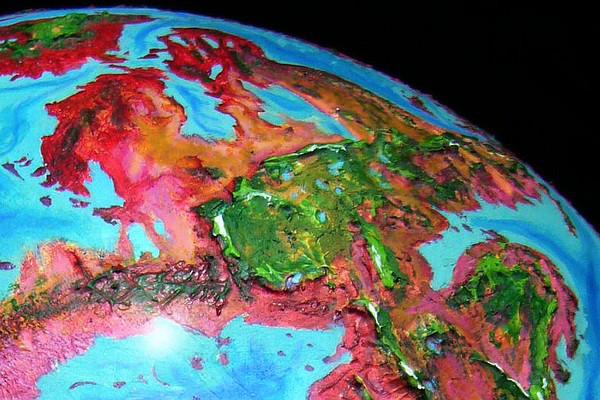
Southwest Bel. Looking south--equator roughly on horizon |
The rim of the plateau breaks into a jumble of hills. Finding updrafts is a little more complex now. But the wind's off the sea and still generally rising. You slow, and veer northwest toward the heights, but the flyway's never truly hard.
Two mountain lakes perched on the rim.
Three days of spurs between broad valleys; your flightpath winds, trying to stay in the sweet zone between thin, unflyable air and oven heat. Confusing, but your course is now nearly due west.
One final deep slash. Across it, a huge range, so tall some peaks bear the first snow you've seen in weeks. Familiar peaks. That's Therron Spur. You've come full circle.
Grand summation! Insert folksy wisdom undercutting postmodern pretension.
And then tearful farewells... if I live long enough to ever really write this tour.
World Dream Bank homepage - Art gallery - New stuff - Introductory sampler, best dreams, best art - On dreamwork - Books
Indexes: Subject - Author - Date - Names - Places - Art media/styles
Titles: A - B - C - D - E - F - G - H - IJ - KL - M - NO - PQ - R - Sa-Sk - Sl-Sz - T - UV - WXYZ
Email: wdreamb@yahoo.com - Catalog of art, books, CDs - Behind the Curtain: FAQs, bio, site map - Kindred sites