Capsica's homepage, map, giant ref map, geography, gazetteer . More worlds? Planetocopia!
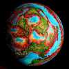 Capsica: Lamia Peninsula
by Chris Wayan, 2022
dedicated to Covid-19, for giving us all
so much nice time home alone
Capsica: Lamia Peninsula
by Chris Wayan, 2022
dedicated to Covid-19, for giving us all
so much nice time home alone
INTRODUCTION
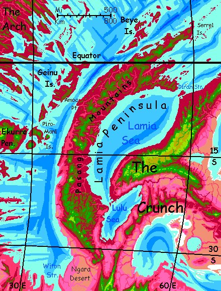
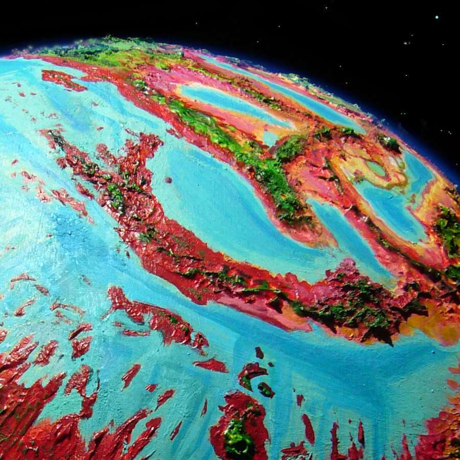
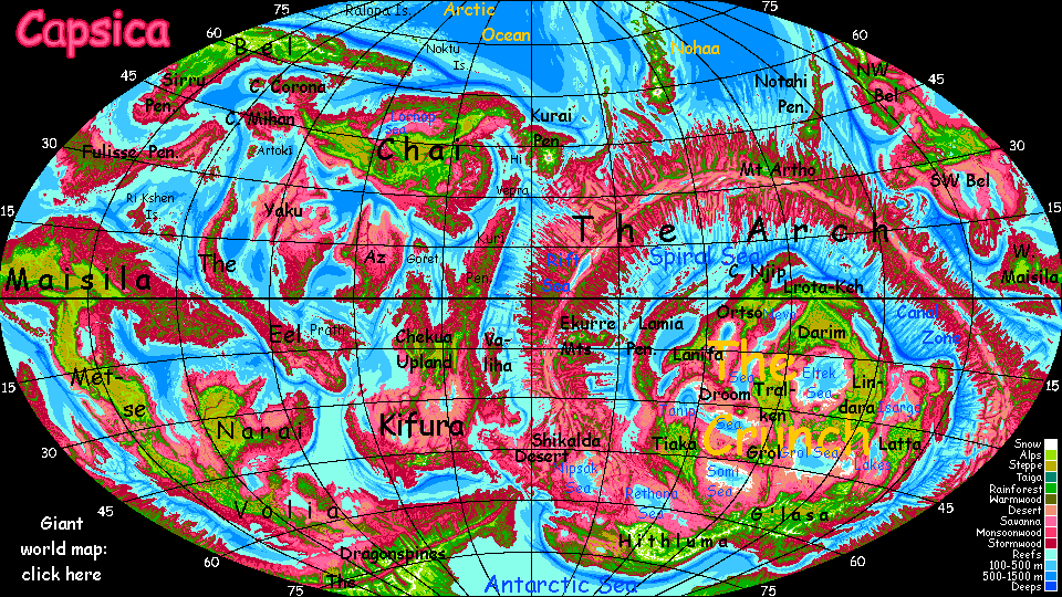
The Lamia Peninsula off the northwestern Crunch is a volcanic arc similar to our island arcs--it's just that Capsica has seas so shallow that these volcanoes haven't formed islands like the Aleutians or Kurils; they've fused into a rugged peninsula as big as all Indonesia. And hotter. And wetter.
The tip of Lamia straddles the equator, its lowlands, wet or dry, summer or winter, are hot even for native Capsicans, and fatal to Terrans: averaging 60°C (140°F) and up to 70°C (158°F). They'd be hotter yet if they weren't so humid; clouds often cover them, except in the west and in the rainshadows of the higher peaks (west or northwest face). The southern end is much drier--the coasts have a monsoon climate--rainy summer, dry winter.
TOURING
The highlands of Lamia are another world--they snag clouds and rain year-round, and temperatures are mild in summer, just 40-50°C (104-122°F), and downright cool in winter (30-40°C, 86-104°F). For obvious reasons, Terrans all tour in winter.
Though snowless, the flanks and summits of Lamia's volcanic spine are green climatic islands in the sea of red. The high meadows of the outer slopes, above 5 km (16,400'), thrust up through the cloud-sea into relatively sunny air. But these heights aren't arid, as on many Terran tropical peaks like Kilimanjaro or much of the Altiplano. Capsica's denser atmosphere, thinning slower in the lower gravity, means high-altitude air holds more moisture than Earth's; and Capsica's tropics have more thunderstorms, especially in global summer, when the little planet swings close to the sun.
The summits are windy and dry enough to discourage trees--the higher peaks have quite Terran-looking meadows, turning gold in the winter dry season, greening again with the summer rains. It's the shoulders just below, with small creeks and shade trees, that are ideal camps for tourists. You don't have to ask permission; the locals won't mind. For them, these heights are cold windy holes frayed through an otherwise balmy, pleasant climate.
THE SOUTH
We'll assume you're entering the peninsula from the base, from the southwestern Crunch.
Your flyway will be a chain of steep stratovolcanoes, the Pasang Range. Breezes are mild at this latitude, but they come from the east, hit mountain walls and build cloud-towers--plus updrafts you can ride. Stick to the east side of the range. To your west, the Ngara Desert. Red snakes of rivers writhe on a dusty tan plain.
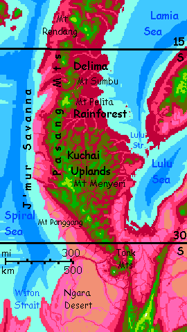
The first cluster is the Tonk Range, a tangle of green dormant volcanic cones, with arms trailing off in four directions. To the northeast, ruby woods and lilac savannas stretch down to the plains, to merge with the coastal forests around the Lulu Sea. Veer left a bit and camp on the shoulder of the tallest peak, Mt Tonk, 4.6 km (15,100'). Green woods, swimmable creeks. At the great peak's foot, the Ngara River, a fertile red crescent where most of the region's population lives and farms. Beyond, just the tawny dunes of the Ngara.
North and a little west, along the spine of the Kuchai Plateau. This wildly dissected highland is a maze of misty green ridges and deep red canyons--courtesy of the much heavier rains here as we creep away from the mostly arid Crunch onto a cape flanked by two hot, tropical seas.
And it's going to get wetter.
Camp on Mt Panggang, a triad of cones on a common base; the northernmost reaches 4.6 km (15,100') and its shoulders are mild after the muggy heat below, at just 3-4 km (10-13,000'). Here you face a pseudo-choice--you see locals by the dozens veering northeast, onto a popular flyway over into the heart of the Crunch. It's fine for Terrans at first--highlands all the way to Lulu Strait. But on the far side, hot red tropical lowlands sprawl hundreds of km before the hills of Lanifa rise high enough for you to survive the night. Terrans with training and preparation can make that passage and live, but don't. Just don't.
North along the Pasang volcanic chain. Two peaks a day, roughly--big ones average 100 km apart.
Only a day north, you reach Menyeri. It's a stratovolcano 6.1 km high (20,000'), second tallest in the Pasangs. Menyeri's summit cone isn't snowy of course, even in winter, but is chartreuse with cold-adapted grasses and ferns; the peak reaches above the cloud forest capping most of the Pasangs, into the zone fed only by summer thunderstorms.
Two days along the rim of the Kuchai. No great volcanoes, but consistently green, above 4 km (13,100').
Late afternoon. A dip 50 km across (30 mi) down into the olive zone of mixed red & green forest; uncomfortably hot. It's the last gasp of the Kuchai Upland. But there's a refuge looming ahead--a second giant, steep cone, Mt Pelita, 5.2 km high (17,100'). Camp on the shoulder. Blessedly cool. By midnight it's down to 30°C (86°F).
Next morning you head out over red ridges--quite rugged, but too low and hot for you--toward the next great peak. You'll face this pattern for the rest of the trip--hopping between sky-islands.
The next great peak is odd--not a cone, but a crooked stone claw--Mt Sumbu, snagging great cloud-banners. This is what remains of Pelita's big sister; Sumbu, some time in the last 10,000 years, blew itself apart, leaving only this shard 4.5 km high (14,800'). But you can't camp on a crag, and the lower slopes are dripping, in the clouds. Break for lunch, then press on!
The deserts on your left are gone. A pale shimmering lilac, rippling in the wind--J'mur Savanna. Red veins where creeks descend from the Pasangs.
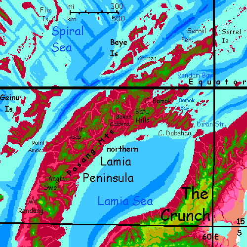
And on your right, the open woods are nearly unbroken forest now--Delima Forest, largest on the Peninsula. We're entering the equatorial belt. Rains near-daily, even now in orbital winter. If humid heat bothers you, turn back; it'll get worse.
A broad red gap. Anxious hours of lofting high up into cooler realms. But you can't sleep on the wing...
Relief! Just grudging olive hills at first, but they steadily rise and spread into a massif. That cloud-castle ahead of you hides a giant: Mt Rendang. Its spectacular west face rises from sea-level savanna through red monsoon woods to green cloudforests, then chartreuse fern-fells above the cloud layer, up to the summit at 6.4 km (21,000'). Even now in orbital winter it's quite snowless of course; by now we're barely 12° from the equator. Find a pool up where there's still shade, near the treeline, and cool off. Enjoy your rest. Up here it's barely 30°C (86°F) in daylight, and in the high 20s at night (c.80°F)--the coolest you'll get on this entire trip.
Two more days northeast along the Pasangs. Here, ancient flows built up into the Angin Swell, not a true plateau but a stretch consistently 3 km high with small cones rising another km or more (10-15,000'); not cool like Rendang's cone, but bearable, with shaded camps and water. The high Swell is green cloud forest; a few peaks are opener, above the typical cloud levels; both east and west now, the lowlands are ruby rainforest. This far out on Lamia Peninsula, rain can come from every direction. No more rainshadows!
The Angin Swell ends after two easy days. You cross a red misty gulf toward two freestanding volcanic massifs. Head for the left one, it's bigger and offers you your best choice to escape Lamia Peninsula. Others are possible but grueling, even dangerous; this one's reasonable. For the tropics.
JUST PASSIN' THROUGH
Half those offworlders you've seen, clumsily flapping around in their strap-on wings, aren't here for the Sumatran scenery. The Lamia Peninsula and its halo of islands have the only non-polar crossing of the Spiral Sea from the Crunch to the Western Arch--two of the biggest landmasses on Capsica. Though it's a hot, hard flight even in orbital winter, it is possible for Terrans.
Head west to the Amoc Peninsula. It's not quite a full day's travel, but rest early and long. You'll be glad you did.
Well before dawn, you get up and start the crossing--from the Amoc Peninsula over Geinu Strait, 200 km (125 mi) wide. But from green height to green height, it's more like 250 (150 mi)--several hours with no rest possible. Even if you can crash-land on land, you'll steam to death down there.
Over a cloud-dotted sea--turquoise in the sun, indigo in the shadows. Well before sunset, clouds ahead mount into tumbling thunderheads over the hills of Great Geinu. More than hills--you camp at 3200 meters (10,500'). Hot for this latitude, and altitude, but you're so exhausted you still sleep.
You ride thermals up into clouds to get some relief and head steadily south down the Big Island, then the lesser Geinus, a rugged chain of long isles with twisting ridges, looking a bit like the Philippines, if your eyes saw infrared. Ridgetops here are lower and hotter--you camp and rest, but it's midnight before it drops below 40°C (104°). A sweaty miserable night.
Dawn. South over a strait nearly 100 km wide (60 mi). But that's nothing to you by now. Clouds mount into tumbling thunderheads over the hills of the Piromani Isles. Head west. Yes, it's afternoon, but you're not getting much sun-glare in your eyes. Plenty of clouds, even now in the (relatively) dry season. These rugged islands force the air up until cloud-caps form. You camp here in comfort at 4300 meters (14,000'); it's a mere 35°C (95°F). And it'll drop five or ten more at night.
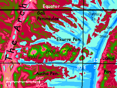
Over the narrow strait to the Ekurre Peninsula. Congratulations! You've left the Crunch and crossed the Spiral Sea. You're now on the Arch, the world's largest landmass (not exactly a continent). You haven't set foot yet--you can't. It's red rainforest down there, 50°C (122°F) and 100% humidity. But there's no shortage of cool highlands in Ekurre. Soon, green heights peep through the clouds ahead. You camp 3.8 km up (12,500') in a green forest that could be Amazonia on a hot night.
Next morning we'll head west over a steaming red rainforested plain (like a big bowl of borshch) to the slopes of Mt Rirato, a shield volcano 8600 meters high.
Prepare yourself! The Ekurre volcanoes, more Martian than Hawaiian, make Lamia look almost like home...
THE NORTH
Congratulations to you hardcore types who want to complete the Lamia Peninsula tour before heading on--hot though it gets as we near the equator. Here goes...
From the Geinu Strait fork, head three days northeast up the great Pasang chain.
End of the first day: Mt Asap. This is the only active volcano on the Peninsula. Well, Asap is just one of several cones on a broad base 3 km high; its summit (currently) is 4.9 km high (16,100'). The platform is green cloud forest; Asap's summit is opener, above the typical cloud levels.
Avoid the active cone. This isn't a nice safe Hawaiian lava fountain; magma here is thick, often plugging vents, causing infrequent but deadly explosions. The lesser cones are rainier, below the clouds, the highest just 3.8 km (12,500'), but still... indulge me and camp there anyway. Just in case.
Two days later: Bakar Caldera. Just a thousand years ago this was a stratovolcano 5-6 km high (16-20,000'), but it collapsed catastrophically, leaving a C-shaped ridge 4 km high on the west and north, cupping a jumbled mess. The caldera's partly filled with lesser, recent cones. Many thermal pools. Sadly, no spa. Not even the locals want a hot soak--we're on the equator, after all. Plus, it stinks. Sulfur-rich. Too rich.
Two more days northeast up the Pasangs. Here you have three choices. But cheer up, it's easy--two are doubtful to hopeless.
East a day through the ridges of Batu--not volcanic for a change, but compression ridges as Lamia Peninsula's squeezed by the Rift to the northwest. Like a corrugated roof--if that roof were painted red, then green, then the green started flaking off... Cover in tattered cloud and simmer a million years...
Jag south AGAIN, then east AGAIN. Now you're skirting the fractal shores and myriad islets of Bomok Bay. Same thing, though smaller. Still just as impassible.
Now you have a clear run. Too bad it's so hot--the Dobshao Hills, a rugged country of maroon and olive forests on washboard ridges topping out at just 2.9-3.3 km (9500-10,800'). Survivable, but days are rarely below 35°C and mostly 40ish (95-104°F). Oh, and muggy of course. Ride the updrafts, avoid effort, camp early. You don't sleep well.
Too bad. Diran Strait ahead is even more grueling. Not the strait itself, but the far side--it's low rolling jungle for miles... but it's the only way into the Northwest Crunch
World Dream Bank homepage - Art gallery - New stuff - Introductory sampler, best dreams, best art - On dreamwork - Books
Indexes: Subject - Author - Date - Names - Places - Art media/styles
Titles: A - B - C - D - E - F - G - H - IJ - KL - M - NO - PQ - R - Sa-Sk - Sl-Sz - T - UV - WXYZ
Email: wdreamb@yahoo.com - Catalog of art, books, CDs - Behind the Curtain: FAQs, bio, site map - Kindred sites