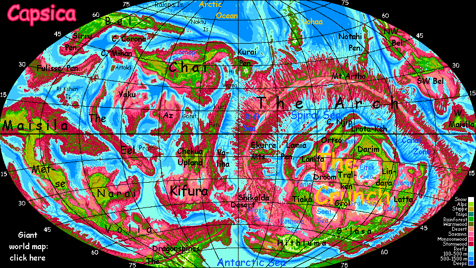
Capsica's homepage, map, giant ref map, geography, gazetteer . More worlds? Planetocopia!
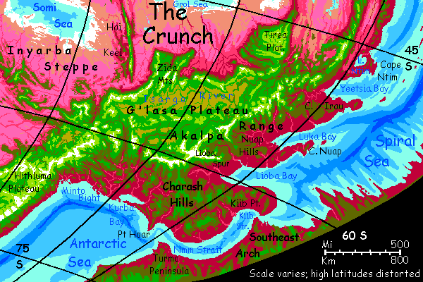
 Capsica: G'lasa Plateau
by Chris Wayan, 2010-2022
This one's dedicated to Covid-19 for
giving us so much time home alone
Capsica: G'lasa Plateau
by Chris Wayan, 2010-2022
This one's dedicated to Covid-19 for
giving us so much time home alone
Introduction - Botany - Zoology - Touring - Nmm Strait - East - North - West - South -
Cold, on torrid Capsica, means something different: basically, "Earthlike". We'd call the G'lasa Highlands mild-temperate, with some winter snow in the higher mountains, even a few small glaciers, but nothing like our Antarctica or even Greenland. Or even Iceland. Maybe California or Colorado.
The trouble is, Capsican life hasn't evolved for snow. For natives, this mild subpolar region--one of the few Terrans would live in year-round--is frightening, alien, and truly dangerous.
Intro - Botany - Zoology - Touring - Nmm Strait - East - North - West - South -
Most Capsican vegetation is reddish or purplish and uses a light-capturing molecule we'll call rhodophyll. It's adapted to a temperature range of 30-80°C (86-177°F). These rhodophores predominate in the lowlands and low latitudes; in highlands and near the poles the only plants that flourish are green, using "chlorophyll" (well, a very similar squarish molecule using a magnesium atom that absorbs reddish light but reflects green; what else can I call it?)
Ecologically, a second tier of strange-colored, cold-adapted plants should be no surprise. Remember our own cold-adapted evergreens with their dark bluish needles and antifreeze. Infrared satellite photos show ordinary vegetation as bright red, but evergreen forests as black. Capsica's palette just happens to show a similar clash in visible light--plum to purple in hot zones (fading to lavender grasslands in dry regions), and quite Earthlike greens in cold wet zones and golds in cold dry regions. On most of the planet, that kind of cold is found only high up. The Antarctic coast is about the only place on Capsica where green plants march down to the sea.
Intro - Botany - Zoology - Touring - East - North - West - South -
Though Capsica's poles seem balmy to us, animal life here evolved in high temperatures, with enzymes to match. The Capsican word for exothermic is just like colloquial English: "cold-blooded". But they mean blood that merely matches the environment; on average, hotter than human! The key word here is "average". Just as on Earth, such creatures are sluggish and generally less sophisticated, for all but the largest must endure what for us would be severe chills and fevers. Not friendly conditions for running a high-end brain!
Endothermic or "warm-blooded" here means what on Earth we'd have to call hot-blooded: typical body temperatures are around 70° C/158°F. Over most of Capsica, this causes no problems, but here in the polar regions, and especially in the uplands, animals must insulate heavily or die. But it takes a lot of food to grow fat and fur and to sustain ovenlike temperatures inside. Even so, this is evolutionarily easier than retooling a million enzymes--Capsican hot-blooded life is too well adapted for the vast rhodophyll zone.
Worse yet, in the polar highlands, the air thins to only 1.2-1.8 atmospheres--as low as half the pressure at sea level. Flight becomes harder; large animals (and upland beasties are--it helps conserve heat) must settle for a bizarre, clumsy, energy-hungry strategy called "walking". Or they don't settle at all; diversity plummets in the highlands, and no large fliers at all live here. We'd see these uplands as quite French or at most English, with distinct winters but only occasional snow; but to native Capsicans they're as harsh as Siberia... plus Tibetan thin air.
So the commonest animal in these weird polar woods is the licha, a grazer with ridiculously thick fur: like a deer with a Persian cat-coat and silly vestigial wings, like a costume from a Nativity play confusing the asses and the angels. Licha are common, but you won't see many; they're wary.
They need to be. I haven't yet deduced if the Antarctic's top predator resembles the wolf, puma or Siberian tiger--but licha will be their prime target, and in these woods hunting will be by stealth.
In opener grasslands it's a different story. Hiding's pointless here, so you'll see great herds of ubirak, larger hoofed ruminants relying on fat and football-huddles to get them through the dark storms of winter and skulking predators. Animals the size of a cow retain heat well; they're shaggy in winter, but not furballs like licha! Aside from the wings (used to flap warnings) they seem a sort of buffalo-moose hybrid. Quite Terran; but is that surprising, given such Terran conditions?
One difference: "what big eyes you have!" Unlike Earth's grazers, who don't venture deep into the polar zone, ubirak and licha get within five degrees of the pole, where winter darkness can last months. On the rest of Capsica, three moons keep the nights deep blue, not black; but during polar winters, storm clouds and the bulge of the planet often hide all the moons, too. So licha and ubirak have night vision rivaling a cat's! And need to. Attrition from predators is severe in winter; the dark lets hunters creep in close. Plants stop growing; many die. Famine times! Winters here are hard and precarious, quite without ice.
Intro - Botany - Zoology - Touring - Nmm Strait - East - North - West - South -
Yay! G'lasa is one of the few regions of Capsica that offworlders can tour with any safety. It's also one of the few tours we don't have to conduct entirely in winter, and that's lucky, since you'll need the light. So my plan's to start in fall at Nmm Strait, wind through the Charash Hills then north along the east edge of G'lasa Upland, on the right side of the map, so we slip into winter as we reach hotter latitudes, and circle the great upland counter-clockwise. Seasons change fast on Capsica--barely nine weeks each--so we'll be in deep winter as we skim the edge of the deadly desert basins on the northeast side. Sweaty, but not fatal. In fact, the roughest bit may be crossing the southern G'lasa highlands in winter--some high passes there. We may actually see snow!
Intro - Botany - Zoology - Touring - Nmm Strait - East - North - West - South -
We'll start at Nmm Strait on the Antarctic shore. It feels balmy--tropical in fact. Not muggy--cold dry air falls at the pole and blows outward, in steady sea-winds that paradoxically don't carry that much moisture. Only a day or two back they were in the stratosphere; not enough time to pick up much water from the sea. Still, they aren't the freeze-drying blasts of Earth's polar zones, where the winds are so cold they can't pick up moisture. Summers here get dry, with a few mild rains and many fogs; in winter, polar storms sweep through. Not our white blizzards, but black gales of driving, sleety, bonechilling rain. "It was a dark and stormy night"--for months.
In Earth's Arctic, winter is the time to travel, despite the dark. Ice makes an easier road than summer's bogs and treacherous waters. Not so on Capsica. The few polar natives are migratory fliers; they come here now, herding and harvesting in summer when skies are often clear and the endless low light makes travel easier.
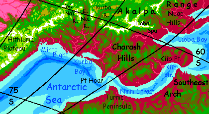
You head almost due north the next day, up winding valleys into the Charash hills, feathered in rust and green. Hard to sleep though. The sun does set, but it doesn't creep too far below the horizon, and there's always a moon or two up. Midnight blue at most; never true dark.
Blearily, you head east for three sleeps-and-wakes, along a coast dappled plum with distinctly less green. We're on the fringe of the Antarctic here; that unnatural corpse-green chill has almost faded back to Capsica's normal ruby. Last chance to turn back south, to a tour with truly Earthlike climate.
The Charash Peninsula is unusually placid for a land near a rift zone: rounded hills clad in red and plum-purple forests, with scattered pink meadows and cyan lakes. Inland, the heights cool to olive browns: mixed trees. Chlorophyll pioneers.
Three days and 1000 km north through the hills, it's about the same. We're creeping upward, but also creeping south. Chlorophyll and rhodophyll battle to an uneasy draw here. Winding valleys with riverine woods form plum-colored tentacles below olive slopes and pale green, even gold grassy hills--just a single kilometer above the Antarctic Sea, the rhodophores give up. Winter winds near freezing? Just unbearable!
But here, that green line's crept up to 2-3 km. You're feeling no cold. The temperature's still 35°C (95°F). About the best I hoped for.
At last, ahead, a definitive green wall: G'lasa. This high plateau is analogous to a Terran continent. Like Venus and Mars, Capsica has few continental platforms with clear, sharp drop-offs--our deep seas shaped most of those! Still, there are some, especially here in the hemisphere called the Crunch--and G'lasa's the southeast flank of that huge complex of mashed-together miniplates. Rocks here are lighter: sedimentary and metamorphic, with of course volcanic intrusions--ubiquitous on busy Capsica. But overall, G'lasa's like a balsa raft floating on the great Capsican sea of dense basalt.
The rim is emphatic--the Akalpa Mountains are much like our Himalaya, just not as ice-sculpted. Peaks up to 8 km (well over 26,000'), with passes over 5 km (near 17,000') leading to plains around 4 km up (13,000'). These mountains aren't the highest on Capsica, but some of the coldest. Winter snowpacks can be substantial, with temperatures below freezing for days on end. Few glaciers--mostly at the south end. Even Himalayan heights thaw out every summer. Subpolar not polar.
In G'lasa, you can hang-glide with your strap-on wings, but true flight's not so easy. Still, it's just possible. The gravity's low, and the air pressure is 1.6 atmospheres in valleys (though it thins as low as 1 on the highest peaks). But we don't need true flight; all these sun-heated rocks, next to cool lakes (usually on Capsica that means "not scalding", but here it means what it says: swimmable in summer but honest-to-god cool, and cold in winter and spring) and lake-cooled air create formidable updrafts and downdrafts. No need to work at flight--let the mountains lift you. Brains not brawn! So you zigzag a lot, but generally head north in comfort--up here, it's only 25-30°C (77-86°F). The coolest you can expect on this trip.
Intro - Botany - Zoology - Touring - Nmm Strait - The East - North - West - South -
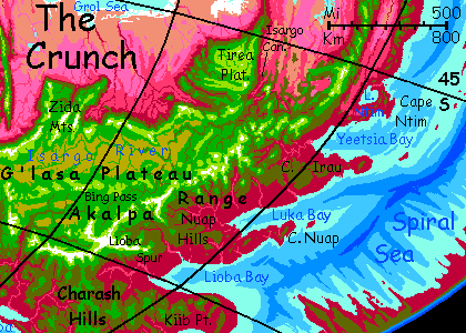
North along the great flyway of the Akalpa Range. The Charash Hills gradually fall behind, exposing the full height of the Akalpas.
Out Lioba Spur. Far to the east, a bright gleam: the head of Lioba Bay, the first of three great sounds divided by hilly capes.
Northwest over Bing Pass into G'lasa Highland. Rugged, truly green here in the SE half, unlike the Isargo Altiplano in the northwest. We're slipping inland to avoid a difficult wall in our path north, the Nuap Spur. Snow on those peaks!
Three long days north.
The Akalpa Range slumps for a couple of hundred km, around Yeetsia Bay; it's easy to cross back to the coast side. Ahead, snowy Andean peaks down to the sea in one big sweep. Green above, red below. We've flown so far north in the last week or two we've stumbled into Capsican normality.
Camp above Lake Ntim. Here you could choose to continue north along the narrowing Akalpa chain--no more plateau, no more snow, just a monster wall across the prevailing winds, making a fine flyway--into the Southeast Crunch--lesser plateaus and island arcs above a muggy red coast. Inland, lush grasslands around great lakes--turquoises set in a lavender plain. Huge herds of winged... something. You can't dive down for a closer look, even though it'll be full winter by then and those Mediterranean basins have dropped to 45°C (113°F).
It's a long sweaty trip. Let's stick to G'lasa instead.
Intro - Botany - Zoology - Touring - Nmm Strait - East - The North - West - South -
We head west over the saddle of the Akalpa Range and head inland a couple of days, along the north slope of the Yeetsia Mts, riding updrafts around 3 km up (10,000')--just waist-high on these giants. Their shady south sides often have winter snow, but not here on the drier, sunny north face. Maybe a few weeks later in full winter...
Two days of green hills and red canyons, thunderclouds ahead. With steady thunder. It's the head of Isargo Gorge, with its two great falls. The Isargo drains half G'lasa; the upper fall's as wide as it is high (half a km--1600'). Nine Niagaras. So much spray it forms a standing cloud.
Explore Tirea Plateau a few days. G'lasa in miniature? Not quite; grassy, open. Ethiopian? Less rain here--we're well inland. Not red forest below, but pink grassland, and that gleam on the horizon isn't the sea, but the southernmost of the region's Great Lakes--still with only a tenth the area of the sea off eastern G'lasa. And the highlands we're on block polar storms. From here on in, trees grow rare...
Again a choice--a line of ridges north leads into the southeast Crunch along a Himalayan plateau above tawny deserts and sunken seas. And not the worst of those (I'd nominate Droom in the central Crunch if I'd written the tour yet. I've been reluctant--the orbital photos look truly ominous.)
South along Tirea's west face to Grol Gorge, where the largest river feeding the Sea of Grol thunders out of the mountains, over its five cataracts. But this is no Isargo Falls; dramatic drops, but the river's total annual flow is just a tenth as much. Its catchment is both smaller and drier.
Do NOT follow the Grol down to the sea. By now it's early winter, and as low as 30°C (86°F) on that savanna, some days, but it can warm back to 40-45°C (104-113°F) unpredictably. These inland basins fluctuate more. Also, it's 100 meters below sea level down there. A real frying pan.
Half a day south after the falls.
Next day, a long flight west. Creeks are few and low--the winter rains haven't begun here--but they still fall in delicate horsetails and plumes a kilometer tall, or more (3-4000').
An abyss opens before you. Red down there--enough rain for scrub at least, and low trees along streams. On the horizon, a tawny wall--another line of cliffs. It's not a canyon exactly, but a big chunky bite out of G'lasa Plateau called Box Cove. Crossable, but it's easier to skirt the rim. Jag south some hours, then west as afternoon lengthen. High peaks on your left, dusted with new snow, growing pink and salmon as the sun lowers; Box Cove on your right, purpling as shadows grow.
A lurid green wall grows ahead of you. Peaks dusted with snow up there too! Hard for natives in that cold thin air... and impossible for you. Camp and rest. Tomorrow we'll plan a way round.
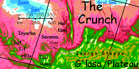
Next morning we head inland, to the heart of the plateau. We're skirting the rugged country of the Zida Range--like Tirea, a great tongue of G'lasa reaching hundreds of km toward the Grol Sea. But it drops spectacularly and uselessly to the plains; you can't cross. Even most Capsicans avoid it. They're rather ride the updrafts along ridges. The Zida promontory's a dead end--scenic, but off the flyway.
That's a bit of a putdown in Capsican.
So, inland. A green mountain wall to your right where you're used to red lowlands. Left and ahead, an endless golden plain--dry grass waiting for the rain. Isargo Steppe covers half G'lasa Upland--it's just the half few visit. Herds of... what? And are they wild, owned, or sentient, their own shepherds?
It's work flapping around up here at 4100 m (13,500'). You're not gasping from oxygen shortage--it's still 1.7 atmospheres and just as rich in oxy as Earth. But your wings have less to grip, and on this plain, you have to flap--the updrafts of the rim are gone. Work at it! Skim the flats, staying low. You'll get a boost from the 'ground effect'--a bubble of high-pressure air develops between your wings and the ground. But what you save in muscle work, you lose in nervous energy; you have to dodge hummocks boulders and trees. Not that there are many.
Hours south, then southwest round the feet of Zida's rugged peaks. West an hour, then northwest. Another range ahead, the north end of the Kra Range. Camp and rest. You'll need it...
Intro - Botany - Zoology - Touring - Touring - Nmm Strait - East - North - The West - South -
In the morning, a tedious climb over Kra Pass (5200 m, 17,000'). But you're used to high-altitude flight by now, and it's worth it. The far side drops kilometers into Grol Basin. Strong, steady updrafts--like a freeway after dirt roads. Whew! Your shoulders can rest.
Scenic, too. Here the rim is green atop great bared layers of tan and red stone, white-plumed with waterfalls a kilometer high. The gulf below you, 4 km deep (13,000') is a dusty, hazy rose abyss.
South all afternoon, though the mountain wall steadily curves southwest. Camp when you can see a strange spire on the horizon. It looks like the end of a huge wall, though you're not sure in the sunset glare.
But in the clarity of dawn, you can see. That's the tip of Hai Keel, a gigantic ridge, or drastically simple mountain range if you like, 5-6 km high (16-20,000') running nearly 1000 km (over 600 mi) north to Grol Upland in the heart of the Crunch. A major flyway, for the prevailing winds slam right into it and generate huge updrafts.
Hai Keel is probably a plate boundary. Well, platelet. A lot of these jam together in the Crunch. The Rift constantly spreads new crust, but if the Rift curves, these fresh slabs of pavement on the concave side of the arc can't just ride along peacefully--they squeeze, fracture and stack. With low gravity and little erosion (dry basins), great ridges like this aren't rare. They exist on Earth too, but only where shielded from erosion, in the abyss (for example, see Albatross Ridge off Central America--except you can't. Miles of water hide it.)
Bless Capsica's relative dryness, for exposing all this deep-sea crustal drama--just as much scenic verticality as that mad sculptor Ice gave Earth! Drought giveth what Warmth taketh away. One could argue for a geographic principle, call it the Bioscenic Law of Conservation of Verticality: "Only tectonically active worlds will circulate minerals well enough to sustain multicellular life, so all inhabited worlds will be scenic! Climate only determines where the scenery is."
But I'm probably wrong. Our sample's too small. Consider: a big, wet world (oh, let's call it Lyr) might drown most or all its land. Not much scenery then, unless you have sonar-senses and either gills or mighty good lungs.
Anyway, scenic alert. The Keel is impressive.
But impressive enough to lure you over a 120-km gap, then on into what I extrapolate is something like Terran hell?
Next morning it all looks the same--mountains to left, dusty abyss to right. But now you're looking down into a different abyss. That's Inyarba Steppe down there--running down to a different sea, the Somi. It too is cut off from the ocean, and is salty and alkaline.
Then the abyss opens before you, too. A huge mountain-prow where the rim turns sharply south. You have to follow; nowhere else to go.
Intro - Botany - Zoology - Touring - Nmm Strait - Touring - East - North - West - The South -
South a day. A low ridge out there grows til it's the far wall of a great gorge. The Isomi River roars in the depths, two miles below.
South another day on Isomi Gorge's east rim. Slowly the canyon narrows... and comes to a head.
Choice: either head west on the rim of Tsal Mesa, then along the Luf Tif Hills, a broken but never quite failing chain of uneven ridges and knots from 3 to 5 km high--sweaty to Earth-cool. They're flanked by two scorching basins--on your right the Somi Basin, quite fatal even in winter, on your left the subpolar Rethona Steppe, now in winter actually visitable--scorching, for you, but visitable. The Luf Tif Hills lead 2000 km (1250 mi) into the Tiaka Highlands, yet another plateau above more simmering, sunken (and sometimes stinking) seas. The Crunch gets repetitious.
But then so are our Pacific island arcs, I guess. Geologically, that is. It's climate that makes the difference. And the basins north of us get pretty bad. Hot dry salty dusty... and that's if I've written them. I'm procrastinating, just as Tolkien was reluctant to drag Frodo and Sam across the deserts of Mordor. Took him years, too.
Let's not go. Instead, if you really want to peel off, stick to the cool mountains--fly south to Hithluma and return to Nmm Strait along the Antarctic Coast, one of few places in the world you really can tour at sea level.
Or finish G'lasa. Head east through green mountains and the chill of high-altitude subpolar winter. When we camp, you may even get to wear that sweater!
Next day, we follow West Nai Canyon down toward the Antarctic Sea. The river's an astonishing, milky turquoise; the first stream you've ever seen on Capsica with glacial silt.
Gradually, woods grow more common; more rain here, on the coastal side. Green peaks, many snowy--we're back at 60° south again, and it's full winter now. Capsica's seasons are swift.
Camp on a knoll. Tomorrow we head east.
Along the Akalpa Front. Strong winds off the Antarctic Sea lift you. Squalls of heavy rain, a first. You actually feel cold! Deep winter's starting.
Midmorning, a great canyon, the East Nai, deeper, bigger. An hour across.
A few hours later, a third gorge, bigger yet--Kurba Canyon. Swoop down two km, against all Capsican common sense, to a warmer, more sheltered camp by that eerie pale-blue milky river. Dry your gear as best you can and rest.
Next day, riding the polar blast, you sweep hundreds of km east. Sun and showers, around 15°C (59°F)--it never gets above 20 (68°F)! Polar winter has begun. Despite the swift winds, no locals in the air. Savage cold and wet for them. Next you'll be expecting them to touch snow (they won't. Immediate burns.)
To your right, the somber plum and olive foothills grow--you've reached the western fringe of the Charash Hills where we began. From here, you can either glide downslope to Nmm Strait and the Antarctic, or just keep riding east two or three days to a narrower, easier crossing, Kiib Strait, that leads out of the Crunch into Southeast Arch--the great spreading zone that stacked all these mountains up.
I recommend that route. Not just because it's geologically very different, though it is; but it'll get you out of this icebox and back into decent Capsican winter climate--nice mid-latitude lowlands from 40-60°C (104-140°F) above high green flyways--cool, of course, just 30-40°C (86-104°F)... but not this wretched cold and rain. This might as well be London!
No wonder lower-latitude Capsicans call Antarcticans insane.
World Dream Bank homepage - Art gallery - New stuff - Introductory sampler, best dreams, best art - On dreamwork - Books
Indexes: Subject - Author - Date - Names - Places - Art media/styles
Titles: A - B - C - D - E - F - G - H - IJ - KL - M - NO - PQ - R - Sa-Sk - Sl-Sz - T - UV - WXYZ
Email: wdreamb@yahoo.com - Catalog of art, books, CDs - Behind the Curtain: FAQs, bio, site map - Kindred sites