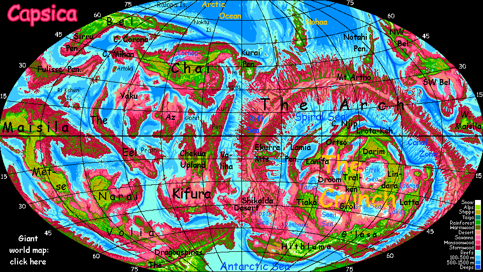
Capsica's homepage, map, giant ref map, geography, gazetteer . More worlds? Planetocopia!
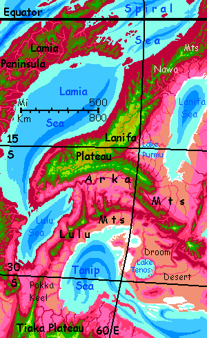
 Capsica: Lanifa Plateau
by Chris Wayan, 2023
Capsica: Lanifa Plateau
by Chris Wayan, 2023
Introduction - Touring - The Lulu Mts - South Rim - West Rim - East Rim
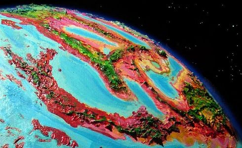
The Lanifa Plateau in the northwestern Crunch is small, as such plateaus go--no bigger than our Andean altiplano. Like it, Lanifa's narrow, just a few hundred km. If Capsica were as wet as Earth, Lanifa'd be just a sort of Sumatra plus a few island chains. Just replace Earth's ocean with an ocean of superheated air... those long island chains are now mountain ranges offering the only access to Lanifa. The plateau itself is small, but our path along those flyways will be as long as Chile.
Northern Lanifa is equatorial; its lowlands, wet or dry, summer or winter, are hot even for native Capsicans, and fatal to Terrans: averaging 60°C (140°F) and up to 70°C (158°F). They'd be hotter yet if they weren't so humid; clouds often cover them, except in the west and in the rainshadows of the higher peaks (west or northwest face). Plant life in such hot zones are distinct: lavender to pink to deep red.
Lanifa's south end is much drier--the coasts have a monsoon climate--rainy summer, dry winter--and the approaches from the south, where we begin, are mountains rising from true desert, some of the harshest land on Capsica.
Introduction - Touring - The Lulu Mts - South Rim - West Rim - East Rim
The highlands of Lanifa are another world--they snag clouds and rain year-round, and temperatures are mild in summer, just 40-50°C (104-122°F), and downright cool in winter (30-40°C, 86-104°F). For obvious reasons, Terrans all tour in winter.
Though snowless, the flanks and summits of Lanifa's mountain ranges are green climatic islands in the sea of red. The high meadows of the outer slopes, above 5 km (16,400'), thrust up through the cloud-sea into relatively sunny air. But these heights aren't arid, as on many Terran tropical peaks like Kilimanjaro or much of the Altiplano. Capsica's denser atmosphere, thinning slower in the lower gravity, means high-altitude air holds more moisture than Earth's; and Capsica's tropics have more thunderstorms, especially in global summer, when the little planet swings close to the sun.
The summits are windy and dry enough to discourage trees--the higher peaks have quite Terran-looking meadows, turning gold in the winter dry season, greening again with the summer rains. It's the shoulders just below, with small creeks and shade trees, that are ideal camps for tourists. You don't have to ask permission; the locals won't mind. For them, these peaks are just cold windy holes frayed through an otherwise balmy, pleasant climate-carpet. Scenic, but as useless to them as any glacier-capped peak on Earth.
We'll start in the south, approaching via the arc of the Lulu Mountains. Long and indirect, but the safest. Every high-altitude route into Lanifa has some gaps, but none along the Lulu chain are wider than an afternoon's flight.
So we'll set out from Tiaka Plateau--or rather its northern tip, a long ridge called Pokka Keel...
Introduction - Touring - The Lulu Mts - South Rim - West Rim - East Rim
You're flying north along Pokka Keel, a rather unearthly straight ridge hundreds of km long, 4.8 km high (3 mi), but no wider than it is tall. When the ridge ends, spiral up high as you can, then flap and glide across the fatal gap of pink-grass lowland, 125 km wide. A couple of modest volcanoes, 2.5 to 3 km high (8-10,000') offer hot but survivable rest stops if you need them.
From the tip of Pokka Keel to the Kenn Range, one of half a dozen....
Storms aren't strong at this latitude, but they come from the east, hit mountain walls and build cloud-towers--plus updrafts you can ride. Stick to the east side of the range. To your west, the Ngara Desert. Dusty red riversnakes writhe on a dull tan plain.
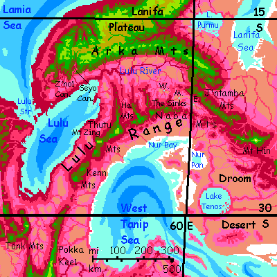
Over a 50-km gap (30 mi) to the Thutu Range. Looks much like the Kenns at first, but South Peak blocked your view of what's ahead. Round South Peak's shoulder, Mount Zing, over 6 km high (20,000')--a broken tooth, pale green toward the snow-free summit. Still, its green shoulders offer good-sized creeks of genuinely cool water for swimming, and air temperatures as low as 25°C (77°F).
Half a day east stands a second giant, Mount Thutu, highest in the range at 6.4 km (21,000'). From its flank Thutu Spur runs north over 300 km (nearly 200 mi). It's possible for the impatient to veer off here and reach Lanifa Plateau quickly this way. Not recommended for Terrans; the Spur ends suddenly, and crossing the lower Lulu Basin is hot, long, and fatal if you tire.
Safer: head east over a gap of 65 km (40 mi) to the Ha Range. Another freestanding highland--no giants, but a solid stretch above 3 km (10,000') for 115 km (70 mi). The Lulus are a mountain range only by courtesy, and when you stand back. Quite intermittent when you need to rely on it for consistent thermal oases!
A short gap to the Naba Mts--like the Has, but longer, a good 185 km (115 mi). To the north, small cut-off basins with small lakes or sinks. West Sink is too far north to see, but Middle and East Sink are closer to the flyway; you can see a few miles of water gleam even now in the dry season, though they'll triple in size during the summer monsoon.
East along the Naba Chain, a line of small freestanding volcanoes barely into the olive zone. Over the next two days the view to the north changes from hazy low desert to savanna hills with high mountains out on the horizon: the J'ntamba Range. On the third day, it gets bit closer--about 80 km off (50 mi). One more day, just to be sure... You rest up for the crossing atop a lonely little peak just 50 km (30 mi) from the green height of the J'ntambas.
But ahead... you see the real reason I led you so far east. Floating high above the horizon, still 200 km off (125 mi), is a white triangle--Mt Hin, 9 km high (30,000')--snowcapped, at least now in winter. An example of something we'll see more of in the central Crunch--not volcanic yet Martian-scale. As the spreading zone of the Arch squeezes the Crunch like a python strangling a pig, small wedges of crust crack free and tilt up to Himalayan heights, often from quite low sea-basins, from desert to fairly rainy uplands.
Well, at least non-parched uplands.
On most of Capsica, Terran visitors travel lonely routes. But in this hot dry country we'll see a fair number of locals up in the olive middle zone, where it's cool but tolerable for them, hot but survivable for you. Rain not temperature decides where people live in the central Crunch, and sky islands this big, even in the driest desert, deliver.
Good thing they do. To the east is Droom. Don't click! Names are hazy and the tour unwritten--possibly unwritable. It's the only Crunch platelet lacking an extensive plateau offering water and cool enough climate for Terrans. Chains of sky islands are the only thermal oases there; runoff from them, the only fresh water in the lowlands. Desert, saltflats, bare hills, and a few giant peaks where livable meadows cling. In the cracks...
Let's not go and say we did (a useful mantra for the Crunch. Supercontinents are a bad idea. Like a lot of super-things.)
Introduction - Touring - The Lulu Mts - South Rim - West Rim - East Rim
North across mostly-red hills to the J'ntamba Mountains.
West along this range for three full days. Pale green meadows (fed by thunderstorms), dark green forests, olive slopes and canyons striped with waterfalls, then red foothills fading to dusty-rose savanna two or three miles below you.
On the third day you pass East Sink, a shallow soapy lake up to 15-20 km wide in the monsoon (10-12 mi), 10 or less in the dry season (6 mi). "Or less" means it dries to a mudflat in bad years.
North through green to olive hills, 3-4 km high (10-13,000') a full day over land that could be prehistoric Earth. Hardly a red tree in sight.
Tall peaks ahead in a line across your path, the Arka Mountains, nearly 6 km high (17-19,000'); even the passes are near 5 (16,000').
Ride the winds west along the south slope of this range. Easy updrafts.
Next day: do the same. Nothing much changes, except the hills to your left drop away into The Sinks--desert basins. East, Middle, West...
Next day: do the same. Nothing much changes except now some of the peaks reach 7 km (23,000'), and to your left is Lulu Valley, dry savanna not desert. The still-distant sea is starting to have an effect. Cascades down the mountainface feed red wooded strips writhing across the plains below.
Next day: do the same. Sorry! the Arkas are 1100 km long (720 mi). You're traversing the entire south rim of Lanifa Plateau. And not just you. The Arka Flyway's popular; just a mile below you, where it's a bit warmer, you see hundreds of local fliers.
Seyo Gorge. A great hanging valley like a dusty-red gash in the green slope, misted by a chain of falls down the center.
Half a day west, similar Z'noi Canyon... a bit cloudier, the greens greener, the reds redder. More reliable rains, lusher forests. We're nearing the sea.
Off to the southwest, a long spur leads to Lulu Strait and tropical Lamia Peninsula. Pretty, but I don't recommend it--the strait is narrow and easy to cross, but the lowlands around it, fatally hot, are 250 km wide (150 mi), with not one safe resting-perch.
Instead, veer north up the length of Lanifa...
Introduction - Touring - The Lulu Mts - South Rim - West Rim - East Rim
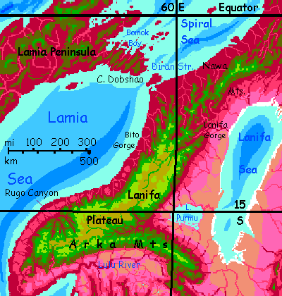
A day north. The slopes seem lush after the Arkas. Real forest, both green and red.
Rugo Canyon--really a winding complex of canyons up covering (or rather excavating) 25,000 sq km (10,000 sq mi). Branches run as deep as 3.7 km (12,000'). Rugo's not even Capsica's deepest. Not quite Martian, but nearly. Of course, low gravity allows higher cliffs.
You spend a full day hopping between green-capped mesas and finding small high-up waterfalls whose spray you can fly through to cool off.
Up a straight coast. Humid, lush. Waterfalls and plum-colored rainforest below you, chartreuse peaks above (despite their height, no snow; you're creeping into the equatorial belt). Not that you can see all that well. The early part of this trip was in dry continental climates; clear skies. Typical Crunch weather. But this coast's tropical and maritime! Big white cloud-sheep graze the lowlands, banners veil the peaks and ridges, and afternoons bring warm, brief rains.
From Rugo Canyon the coast veers east; you ride updrafts a full day. Could be the wet side of a Hawaiian island, scaled up two or three times.
Next morning the coast turns north. All day...
A smaller canyon laced with waterfalls--Bito Gorge, up to 2.5 km deep (8000'). Bigger than the Grand Canyon, but after Rugo behind you, it just seems a geologic afterthought.
The plateau's breaking up here into tongues and spurs. A day crossing deep red valleys, high green ridges.
The next day, at the third tongue, called Diran Spur, you have three choices.
Introduction - Touring - The Lulu Mts - South Rim - West Rim - East Rim
Lanifa Gorge. The Lanifa River drains most of the northern plateau. A massive fall 220 meters high (720'). The spray-cloud hangs for miles... The Lanifa River, and others here in the rainy north, feed the misnamed Lanifa Sea. It's really a vast slow river creeping steadily south until it evaporates at the dry end. 0-1% salinity in the northwest corner, 4-5% in the southeast!
South by west, along the east rim. Savanna below, prairie above.
Day by day it fades into desert. Even the heights grow drier--open forest now, with continuous trees only along watercourses. A strong monsoon freshens the heights, and thunderstorms get them through the winters, but we're creeping back into the continental climate we started in.
After two days, a blue gleam to the west. The sea? Not! That's just Lake Purmu, though it only deserves the name in the monsoon season; when it swells to an island-dotted lake 225 km long and 145 wide (140 by 90 mi). But now, in the dry, much of the lake becomes freshwater marsh, its islets mere hillocks and stands of trees. Not salt marsh and saltflats (like so many inland drainages in the Crunch), for Purmu drains into the Lanifa Sea.
It's an unusually cool day in late winter, but you still can't visit: 55°C down there (131°F). Even the Capsicans don't live here year-round; they visit now to harvest grassnuts and mossels, then retreat to the hills in summer and fall. Of course for the locals it's not heat driving them off during the rains; it's the bugs.
Next day south, the rim bends west--inward. A wide gash in the plateau carved by the many arms of the Purmu River, feeding the lake (and one of the reasons the Lanifa Sea doesn't dry up entirely).
Big cliffs, waterfalls.
South across the canyon complex.
East along the north slope of the Arka Range...
After a day, Lake Purmu gleams along the northern horizon, 125 km away (75 mi).
The slopes below you are dry but not desert; the monsoon here at 15° south is short, but fierce, and hits the Arka front head-on, not sideswiping it like the east rim of the Plateau. And the huge altitude contrast (Lanifa Sea's 50 meters below the world-sea level; the Arkas here reach 6 km; a 20,000' rise, all told) generates lesser thunderstorms even in the dry season.
East a day or two, to the end of the Arkas. South to J'ntamba Ridge, a parallel east-west range, though lower: merely Alpine not Andean. East another two days...
And on toward that white triangle floating in the eastern sky: the snows of Mount Hin, first of the more-than-Himalayan sky-islands of Droom. Or Throg, or... some grim name. For a grim place. The least livable on Capsica! And that's saying a lot.
World Dream Bank homepage - Art gallery - New stuff - Introductory sampler, best dreams, best art - On dreamwork - Books
Indexes: Subject - Author - Date - Names - Places - Art media/styles
Titles: A - B - C - D - E - F - G - H - IJ - KL - M - NO - PQ - R - Sa-Sk - Sl-Sz - T - UV - WXYZ
Email: wdreamb@yahoo.com - Catalog of art, books, CDs - Behind the Curtain: FAQs, bio, site map - Kindred sites