Capsica's homepage, map, giant ref map, geography, gazetteer . More worlds? Planetocopia!
 Capsica: Metse
Outline only!
by Chris Wayan, 2023
This one's for all you procrastinators. I started Capsica in 2010--and here I am.
Capsica: Metse
Outline only!
by Chris Wayan, 2023
This one's for all you procrastinators. I started Capsica in 2010--and here I am.
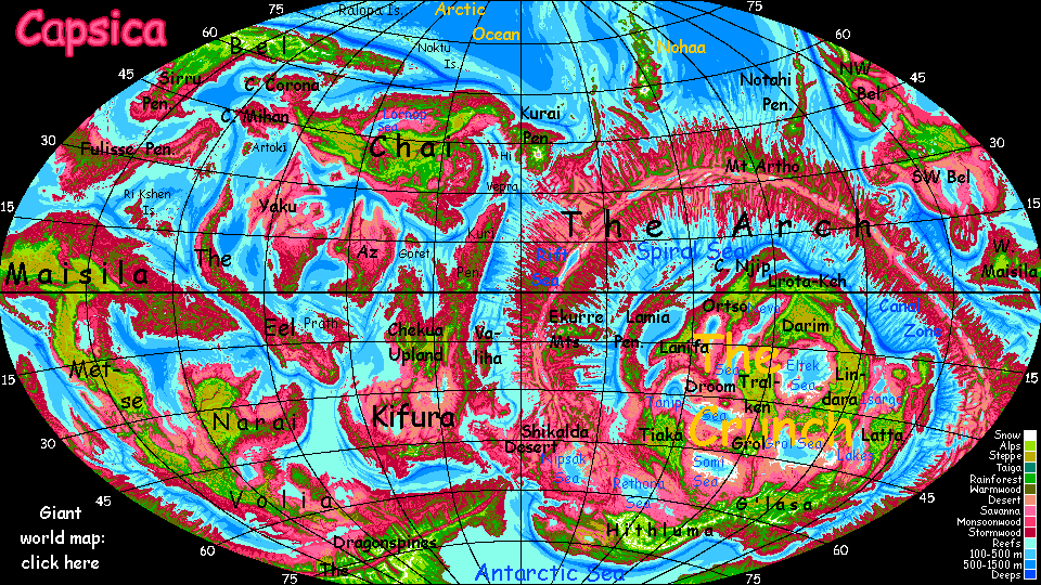
If Capsica's shallow seas were like Earth's, the Maisila region would be something like Australia plus New Guinea plus the continental shelf linking them--a T-shaped land with rugged highlands above a tropical sea. It's just that Maisila's way bigger, rivaling our Africa--its crossbar is massive, and the long stem is quite as rugged as the crossbar.
This tour will cover Metse, the northern half of the stem--at least the parts we can visit.
Capsica's relative dryness means this continental highland of lighter rock is a chain of plateaus, way cooler and drier than they'd be at sea level. Tropical Tibets! Metse is one of the largest continuous highlands on Capsica, and it stands across prevailing winds, creating superb north-south flyways--and a barrier to east-west travel second only to the Arch.
Around the plateaus are a wide skirt of lowlands that'd be ocean floor on Earth, ranging from rainforest to desert. But even the pleasantest lowlands have an angel with a flaming sword at the door--for Terrans only. How flaming? Desert flats can hit 75-80°C (167-177°F). Even in the coolest lowlands, the rainforests (because they're often clouded) temperatures are 50-65°C (122-149°F)--and muggy too. Less an oven than a steamer. The thermal angel banning you from Eden waves a flaming... teakettle.
I put off writing any tours of the Maisila region for years--it seemed so hard to get you through alive. The only way, as is often true in Capsica's lower latitudes, is to stay in the heights--3 or preferably 4 kilometers up--and travel in orbital winter, when it's drier and cooler. If not cool. Even up on the Metse Plateau, it'll be hot. Don't bother bringing a coat. Or clothes at all. All you really need is your strap-on wings. Capsica's low gravity and high air pressure make human flight practical. Besides, there are few alternatives; Capsicans all fly, and land and sea transport (except for heavy cargo) are thus slow to nonexistent. It's fly or nothing.
This tour will zigzag south down the Metse highlands from West Maisila 4500 km (2800 mi) to Volia, clinging mostly to the rims, where it generates great updrafts, letting you ride effortlessly for days--these flyways are popular with locals as well as tourists. The problem is that more than half of Metse is lowland--quite fatal to you year-round. You can look down from two or three miles above, but you can't touch.
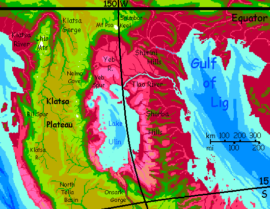
South, down the eastern rim of Klatsa Plateau. Two reasons I favored the east. First, the first few days of the west side got covered in the West Maisila tour, and second, on THIS side, the prevailing winds slam into the rim and rise; you can ride this wall of updrafts for days. That's good, since the humid heat makes exertion hazardous, even 4 km up (13,000'). Just too close to the equator.
Tropicality has its good side. Clouds condense as the winds hit the wall. Shade! Waterfalls and cascades leap off the plateau rim. Rainbows and mist! Much of this tour will be dry; but these first weeks in the tropical zone...
Up on the rim, green alpine meadows and woods. Below, red forests peek through cloud-banners.
Nelmo Cove. Red abyss. A crater? No, just a water-carved canyon complex. Cross the mouth--two miles of air beneath you, dim ruby forests down in the misty heat. Updrafts and down seethe all around you, an invisible boiling pot; you have to work to stay aloft.
Cross to Yeb Spur and camp. Rest.
Mid-morning, down Yeb Spur, a shimmer to the southeast. Maybe 25 km off (15 mi) a great silver sheet--Lake Ulin, a freshwater sea as big as our Lake Victoria or Michigan, some 65-70,000 square km (25,000 sq mi). Oval with a ragged, island-dotted shore. It'll be out on the horizon for days. Lots of villages down there--the Ulin Basin is populous, and ranges from monsoon woods and orchards to farms and savanna.
Just don't be tempted to visit. This is as close as you can get. It's orbital winter, but it's still 55°C down there--131°F. At this latitude, land below 3 km (10,000') is a death zone. Stick to the Tsorfa Range--with peaks up to 8.3 km (27,300') and passes over 5 (16,500'), it offers more than steady updrafts: almost Terran temperatures.
After a couple of days south, the water below recedes a bit--instead of one great drop, the rim's a great stair, with shelves and foothills, olive and red.
Two days, and the escarpment becomes one again---but now it drops to savanna, lavender and bleached pink in the sun. And there's more sun; clouds grow rare. We've crept out of the rain belt; winter's the dry season here, and even the summer monsoon's not as wet; much of it gets spent on the Shorba Hills, on the far side of the lake. Herds of something like ostriches (though iridescent green, a color that stands out in that Barbie-pink lowland) wander the plains. Wild or tame?
The rim turns east. The savanna narrows, the lake nears, til you're staring down at turquoise water two miles below... On the northern horizon, in the sun's glare, you can see a few of the hundreds of islands dotting the shallow lake.
Ahead, Onsark Gorge, a straight slash over 3 km deep (10,000') for over 100 km. We'll follow it south into the Metse Plateau.
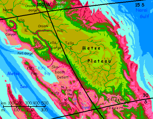
From Onsark Falls, you have three choices.
Two days of high-altitude steppes. Pale dry grass--a very Terran gold, not the pink of lowland savanna. The headwaters of the Onsark are in modest hills called, inevitably, the Onsarks. You climb a low pass--well, low as in 4.8 km (16,000').
The Tella River. West. Deeper and deeper. Stick to the north rim.
The gorge elbows south. Soon a great side canyon opens before you: the North Fork gorge. Cross its mouth. Soon the combined rivers cut even deeper--3700m (12,000'). The Lower Tella is one of the deepest gorges on a gorgeous continent (sorry).
Over the ridge to the west, a very different country--rather Martian. Fori Gorge is nearly as deep, but a jumbled abyss of broken towers and mesas, nothing like the Tella River's straight knife-cut.
A great scarp drops into Skoboosh Desert. Golden dunes two miles below. Rarely, where a stream winds, a rose serpent--hot-zone rhodophyll brush and trees.
Several days southeast. For the first time, out to the west, you see hills rising above the red zone. Not even olive--East Lin Peak, 4.2 km (13,800') is capped in true green. It's just the first of a volcano-field you could use to hop west, all the way to the coast, then up the Kifo Hills to the tip of Kifo Peninsula; they're high and cool enough. Plenty of locals go that way, and on across the Metse Sea to the vast Southeast Arch. But for you, it's a dead end--too long a flight over sea.
Stick to the heights. Southeast along the rim of the Inyat Basin. Here streams don't even reach the sea, just end in brackish little lakes like Inyat and Amoka. You've entered the Metse Gap, the one stretch along the vast plateau complex of Maisila where the highlands break up and every flyway involves some lowland-crossing.
The important thing is to skirt the Edipsa Desert, either on the east or west side. I'll go with the western route; it's a little easier, because the south-facing rim of the next plateau, the K'nash, are in full sun much of the day, feeding strong updrafts to ride; the shadier south rim of Metse Plateau has spotty downdrafts trickier for novices.
Cross the desert south to the arcuate Ksil Range.
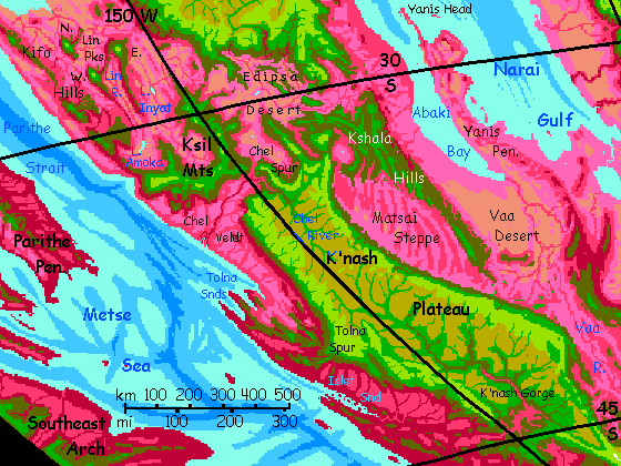
Two days curving south through the green-wooded Ksil Mountains, skirting the hundred-mile sunken sands of Ksil Desert, dim gold below.
The southern Ksil Range curves far west, blending into the long coastal Kifo Hills. Despite their name, these broken, intermittent ranges are 3-4 km high; high enough so you could safely follow this flyway north nearly 1000 km (over 600 mi) to the end of Cape Kifo. These sky-islands, as well as the volcanic Lin Peaks, snag enough rain in this otherwise hot Mediterranean land to send down streams, some to Kifo Bay, some to the sea, but many (like the long Lin River) to brackish inland lakes. Irrigated farms and orchards line these streams. But you can't visit; even in winter, too hot.
This Kifo Flyway leads, for locals, across the Parithe Strait to the southeastern Arch. But at no point is the Strait narrower than 500 km, and from green heights to green heights, 640 (400 mi). Don't risk it. Stick to the Ksil Mountains, cool and green.
Except for the gap yawning ahead, over to K'nash Plateau, third and last of the Metse chain.
Along the north rim of K'nash Plateau. It isn't all desert out there, but brackish Lake Edipsa and the vast, buggy marshes round it, even cooled to their winter low of 40-50°C (104-122°F), aren't kind to Terrans.
After a few days we start meeting stragglers who took the east-coast route down the Metse Plateau and skirted the Edipsa Slimepits Desert on the east, through the Kshala Hills.
Let's ride the winds south along the rim of K'nash Plateau. It's as high as Metse or Klatsa behind us, yet the slopes, streams and falls drop only a mile here--the Matsai Steppe below is a rare, strange mezzanine-land, between the lowlands analogous to our sea-floors and highlands like our continents. On Earth, it'd be a sea inside the arc of the Kshala Islands.
Matsai's just as rainshadowed as the Edipsa Desert, cut off by the Kshala Hills; why is it steppe, not desert? Well, it has been, at times--those long repetitious ridges visible from space are huge, ancient dunes. But wild grass anchors them now. Streams pour in from the heights and vanish, for the sandy soil means there's little surface water, just a few ponds in the troughs between the old dunes where the aquifer surfaces. The only trees are there. But the basin averages 1.6 km high (a full mile): slightly rainier and distinctly cooler than Edipsa, so the valleys are livable--ponds, marshes, and wells support chains of small villages or single, dry farms. Still dangerously hot for Terrans; not recommended. But not dead either.
The lowlands to the west are changing too. With every day, every degree south, we're creeping out of the dry belt into rainier climate--from the equivalent (if much hotter of course) of Los Angeles at the north end of K'nash Plateau, we're now at the latitude of San Francisco heading toward the pole; the west coast is greening fast.
So let's head southwest across the plateau to the west coast and have a look. The plateau's just a few hundred km wide here--just a day or two of tedious high-altitude flight without the updrafts abounding along the rim. But it's just 30-35°C here (85-95°F) and dry heat; you can exercise in that, with care. We really have moved poleward; you see no Capsicans here, on the ground or in their air. Too chilly. They stick to the rims.
This is the highest part of K'nash--the rolling Chel Hills, dividing the Chel Basin (north) from the K'nash (south). Up to 4.6 km (over 15,000'). Thin air and weak updrafts. Try going very low, just above the dry tussocks and boulders of the steppe. You'll get a boost from the ground effect--air pushed down by your wings has nowhere to go, so you get a high-pressure cushion. Effectively, the air's denser, as if you were a kilometer lower.
Still a lot of work. But at least something to grab.
South a day, then out onto Tolna Spur. Steadily greener above--and redder below. Not the duns and pinks of the desert, veldt and steppe you've gotten used to; that's forest down there.
That gleam to the west is the sea! First time in weeks you've been near enough to see it.
To the northwest, the ridges fanning out from Tolna Spur form capes and sounds. Unlike the coast to the north, these coastal lowlands get plenty of rain--we're now at a latitude like our Redwood Coast. Farms, orchards, and lumbering; three large, sheltered, prosperous ports. You could visit those streets--with binoculars, from two miles above. The humidity means their modest heat--no more than 40-45°C now, in winter (104-113°F)--is still fatal for Terrans. Those streets and shops aren't for you.
South of Tolna Spur lies a cooler country, rainy, fertile, mild and densely settled--Island Sound and the lower K'nash Valley. Farms and orchards all over.
Ride the winds along the West Rim Range, up to 5.5 km high (18,000'). The highest peaks, a mile or two above you, are actually snow-dusted now, in late winter.
South a couple of days. Snowcaps now on the peaks, with pale green meadows and deep green woods dropping into equally deep red woods. Cloud-banners wrap the heights more and more often; the clear vistas of the dry zone grow rare.
A full day crossing the dizzying gulfs, freestanding redrock walls and minarets of K'nash Gorge, a dissected canyon gnawing into the south flank of the plateau.
From the south side of the Gorge, it's just a long day of wind-riding southeast to the end of the swiftly narrowing plateau...
...and on into Volia and the Narai Peninsula.
World Dream Bank homepage - Art gallery - New stuff - Introductory sampler, best dreams, best art - On dreamwork - Books
Indexes: Subject - Author - Date - Names - Places - Art media/styles
Titles: A - B - C - D - E - F - G - H - IJ - KL - M - NO - PQ - R - Sa-Sk - Sl-Sz - T - UV - WXYZ
Email: wdreamb@yahoo.com - Catalog of art, books, CDs - Behind the Curtain: FAQs, bio, site map - Kindred sites