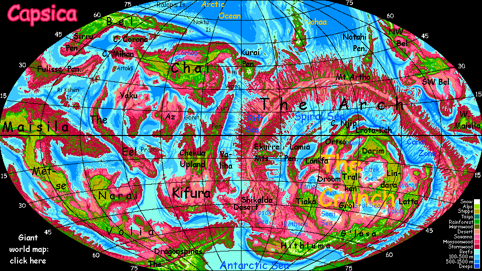
Capsica's homepage, map, giant ref map, geography, gazetteer . More worlds? Planetocopia!
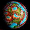 Capsica: Njip
by Chris Wayan, 2023
Capsica: Njip
by Chris Wayan, 2023
Introduction - Touring - Nawa Mts & Thever I. - Njip Peninsula - Eastern Uplands - Southern Canyons
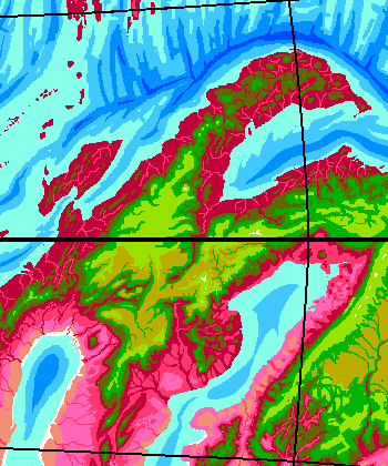
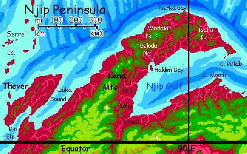
Njip Plateau in the northwestern Crunch is small, as such plateaus go--no bigger than our Andean altiplano. It's complex, though--twisted ranges, dissected canyons. The region's the squashed remnant of a once-sprawling continent, perhaps 100 million years ago. Like our Mediterranean Basin, faults and ranges twist under pressure.
If Capsica was as wet as Earth, Njip Peninsula, north of the plateau, would be a modest island arc--just a few mountaintops poking out of miles-deep sea. On Capsica as it is, though, these mountaintops become thermal islets in a sea of fatal heat (and humidity).
For Njip straddles the equator; its lowlands, wet or dry, summer or winter, are hot even for native Capsicans, and fatal to Terrans: averaging 60°C (140°F) and up to 70°C (158°F). They'd be hotter yet if they weren't so humid; clouds often cover them, except in the west and in the rainshadows of the higher peaks (west or northwest face).
The north rim of the Plateau is similar--right on the equator, rainy and hot. The south side of the Plateau is much drier, but still not typical of the Crunch's arid interior. There's still a substantial monsoon--rainy summer, dry winter.
All in all, Njip's one of Capsica's gardens. Just a bit too hot of a hothouse--for your chilly Terran blood.
Introduction - Touring - Nawa Mts & Thever I. - Njip Peninsula - Eastern Uplands - Southern Canyons
The highlands of Njip are another world--they snag clouds and rain year-round, and temperatures are mild in summer, just 40-50°C (104-122°F), and downright cool in orbital winter (30-40°C, 86-104°F). For obvious reasons, Terrans all tour in winter.
Though snowless, the flanks and summits of Cape Njip's volcanic spine are green climatic islands in the sea of red. The high meadows of the outer slopes, above 5 km (16,400'), thrust up through the cloud-sea into relatively sunny air. But these heights aren't arid, as on many Terran tropical peaks like Kilimanjaro or much of the Altiplano. Capsica's denser atmosphere, thinning slower in the lower gravity, means high-altitude air holds more moisture than Earth's; and Capsica's tropics have more thunderstorms, especially in global summer, when the little planet swings close to the sun.
The summits are windy and dry enough to discourage trees--the higher peaks have quite Terran-looking meadows, sometimes gold in the winter dry season, greening again with the summer rains. It's the shoulders just below, with small creeks and shade trees, that are ideal camps for tourists. You don't have to ask permission; the locals won't mind. For them, these peaks are just cold windy holes frayed through an otherwise balmy, pleasant climate-carpet. Scenic, but as useless to them as any glacier-capped peak on Earth.
We'll start in the southwest, approaching via the Nawa Mountains. Unlike many uplands in the Crunch, Njip is easy enough to get to, if you've mastered flying in strap-on wings; no long fatal lowlands to cross.
So we'll set out from the northern tip of Lanifa Plateau: the Nawa Range.
Introduction - Touring - Nawa Mts & Thever I. - Njip Peninsula - Eastern Uplands - Southern Canyons
You're riding the winds off the Spiral Sea. To your right, deep green wooded slopes and paler green summits; though the Nawas are steep, breaking into cliffs, there's not an inch of exposed rock--smothered in trees and ferns. Too rainy here. Below, maroon and deep magenta canyons, draped in dragons of cloud--as the sea-wind rises, mist condenses. Classic cloud forest.
The sea's out to the left, 1-200 km away. You're so high you could see it on a cloudless day, but the coastal plain jostles with white cumulus. About as sunny a day as you get in the lowlands.
Two days northeast. Rain. Sun. Waterfalls.
After Mt Timus, tallest in the range at 5.5 km (18,000'), the range veers due east. But go on north, just a bit east. Ridges get lower, but still in the olive zone, just cool enough to be bearable.
A wide gap between ridges. Several anxious hours over a sea of red jungle shimmering in fatal heat. It's easy to ride the updrafts along ridges; the heights are clear markers. But finding thermals over a land in patchy, shifting shadows is a lot harder; they move.
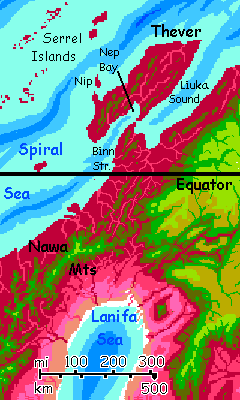
A couple of isolated volcanic cones. You land near the summit on the nearest, and rest up. On to another. Then to more sustained coastal ridges--the Tmm Hills--where you can camp for the night. The lowland clouds hide the sea to the north, east and west--you've crept out onto a peninsula. Only in the morning, as you reach its northern tip at Binn Point, does it narrow enough to make it obvious.
Over Binn Strait to Thever Island. Again, fatal if you fall, but the strait's just 16 km (10 mi)--like nothing after the rainforested gaps you've crossed.
Thever is as big as Java, and quite similar--rugged, rainy, equatorial. A wee bit warmer--averaging 60°C (140°F). Rarely too much more--the heat guarantees typhoons most of the year. Luckily for Terrans, the similarity to Java includes volcanoes rising into a much cooler zone--now, in orbital winter, the summits are no more than 35-40°C (95-104°F).
Two peaks on the south side of Thever loom right over Nep Bay, allowing you at least a distant view of Port Nep two miles below--catamarans crowd the docks, loading smoked janga fruit from the orchards all over the lowlands--purplish trees with bright green fruit, where Java has terraced ricepaddies. Theverians have wings, so harvesting from tall trees is easy; orchards are far more common than cleared fields, all over Capsica.
Fly to the green-tipped ridge at the head of the bay. From here it's just a few ridges west, a few hours on the wing, to the north coast of Thever. A small bay, 25 km wide (15 mi), a low rugged point, and on the horizon, the Isle of Nip. Low and deep red, wooded shore to shore, it's a perfect stepping-stone to the Serrel Islands, a flyway to Lamia Peninsula. A string of flyers, black dots agains the pale Capsican sky, is headed out. But you can't join them. The Serrels are low, lush tropical islands. And as such, utterly fatal for you.
Southeast back to Nep Bay. Across Binn Strait and down the olive Tmm Hills to those solitary volcanoes. South by east from the last of them, a bit east of your outgoing route. It's about 50 km (30 mi), to a green spur of the Nawa Range. You land and camp, and if you're smart, swim & stretch out the kinks from your week-long island detour. No more of that, I promise.
In the morning, follow that ridge straight south. At noon you reach a narrow gap, barely 15 km (10 mi), and cross to a cliff-walled mesa... first finger of Ortso Plateau.
Introduction - Touring - Nawa Mts & Thever I. - Njip Peninsula - Eastern Uplands - Southern Canyons
Northeast along the rim of Ortso Plateau--three full days. To the left, an abyss full of deep magenta hills half-shrouded in clouds. We're nearing the equator; even now in orbital winter, that rainforest is more than Earth-tropical--fatal in hours. In orbital summer, make it minutes. Relentless rains like standing in a scalding-hot shower. To the right, the cooler highlands of Ortso are merely Amazonian--dense green woods ending, beneath you, in a great scarp wreathed in clouds where waterfalls a kilometer high leap off the plateau. Inland, on the horizon, are lighter green peaks 5-6 km high--Earthlike fern-meadows above most of the rains. On Earth such tropical heights can be quite dry; on Capsica, the denser air and lower gravity let some thunderstorms climb that high.
Up this oceanward flank of Njip Peninsula... the plateau to your right narrows into the Kena Mountains, still over 5 km high.
Two days along the Kena front before it breaks up. Ahead is South Belodu Crater--one of twin shield volcanoes with calderas 20-25 km wide (up to 15 mi)--green highlands cupping olive and red lowland forest. The crater lakes common elsewhere are absent here due to those relentless equatorial rains; erosion eventually breached both ringwalls, draining the lakes. The caldera floors are just rumpled hills--young cones, plugs and domes. These volcanoes aren't through yet. They destroy and rebuild themselves regularly!
Stick to the ringwall, mostly 4 km high, topping out at 5 (16,500') on the south rim, high enough even here on the equator to be quite comfortable in the shade of the green high-altitude forest--barely 30-35°C (86-95°F) now, in orbital winter.
Next day, up the west rim then across to North Belodu. A bit wider and rounder caldera. The rim's much the same height.
Northeast to Mindotan Peak. The high point on this caldera, the largest volcano in 1000 km, hits 6 km (19,700', and still quite snowless). There is a crater lake here--though small by Capsican standards, a round eye 10 km wide (6 mi--less than Oregon's Crater Lake). Though our lake's not stained lurid purple by extremophilic bacteria. Mindotan's vigorously pumping minerals into that water. Yum! Hot sulfur soup.
Northeast a day or two, volcano-hopping, to Mt Tserka. Two miles below you, the great port of Tserka Bay; with binoculars you can see the trade booths and shoppers you can't join. Sigh! Plaster your face to the shop window, but you can't go in where it's warm. You're a snowman, an ice-child who'd melt to death in an hour.
Southeast to Tlunep Peak, 4.7 km high (15,300'). You've reached 90 degrees east for the first time. Next day, east to Tsallu Peak, almost as high...
But I don't think you should go farther east, out on Cape Pitkib. It's a dead end for you, but a dangerously tempting one. Straggling Vs of Capsicans fly south like migrating geese; but you mustn't--a long flight over steamy lowlands and deep water. You might well make it to Cape Mooth on the mainland of the Crunch, but I wouldn't risk my life on it.
Instead, let's head west along the Njip Gulf coast. Olive highlands, hot but tolerable--plenty of water and shade. A long day west to the south shoulder of Mt Tlunep, then southwest along a chain of green subsidiary cones studding olive-drab compression ridges. This is an island arc marking a place where plates collide, even if Capsica's low sea level has fused all the islands and bared much of the under-chassis that'd be discreetly hidden on soggy old Earth...
Halden Bay! Camp on the high ridge on the west, right above the bay. Do NOT land on Halden Island, scenic though it is (like an oversize Moorea shot in infrared; nappy-carpeted crags). Steep, scenic, misty, but just too low and hot for your cold blood.
At the head of the bay, Port Halden's famous for tropical fruit, medicinal herbs, and a raucous music scene on those mild tropical evenings when the day-heat cools to just 45 or 50°C (113-122°F). Sorry, no Capsican bands for you! If you want music, play a flute on the mountaintop. You're biochemically sentenced to life on Capsica as a solitary Daoist sage (drunk or not is up to you).
South a long couple of days, skirting the Torth Rainforest. Waterfalls drop into a rumpled red chaos--hills far too low and hot for you to explore.
Sleep on the shoulder of Mount Yuko, highest on Njip Peninsula--7.9 km (nearly 26,000'), and actually snowcapped--at least for now, in orbital winter.
Next day, south to the rim of Njip Plateau on the mainland of the Crunch.
East across the mouth of Torth Canyon, 3.2 km deep (2 mi)...
Introduction - Touring - Nawa Mts & Thever I. - Njip Peninsula - Eastern Uplands - Southern Canyons

East along a straight coast. Humid, lush. Waterfalls and plum-colored rainforest below you, chartreuse peaks above (despite their height, no snow; you're right on the equator now. Not that you can see all that well. Big white cloud-sheep graze the lowlands, and banners veil the peaks and ridges. Not much of the mainland Crunch is tropical or maritime, but this coast is an exception; you could still be on Njip Peninsula.
Impossibly, one cloud-veil is stable. Head south up the slope. Thin air and hard work as you climb past 5 km (16,500') but it gets steadily cooler until ou could almost be on Earth. As you creep above the clouds, an astonishing wall of ice-sculpted peaks looms above you, 8.2 km high (nearly 27,000'): the Ajun Range.
Yera Canyon at their feet cuts nearly to sea level; one of the most extreme altitude drops on Capsica.
A full day east; the Ajun peaks above you slowly dwindle from ice-carved fangs to pale green grassy or ferny domes, cones and mesas--monster molars--just 5-6 km high (17-19,000') more like the knobby, rain-sculpted uplands of Ethiopia or Papua. We are, after all, on the equator; it takes a Himalaya here to generate ice. I wanted you to see this shift in the same geological formation to show how the uplifting force and the rocks lifted can be identical but get shaped very differently, when nature switches from ice's chisel to rain's brush; and temperature determines that, on Capsica just as on Earth. The thermocline here is just miles higher.
Next morning you face a decision: the lower, broken Ajuns have passes now that you could take. Or you can continue east to the L'rota-Keh Uplands; a bigger coastal, equatorial highland--if of course I've written that yet!
But I want to show you the other face of the Crunch: the dry side. Even if the monsoon here is so strong it's not very dry, by Crunch standards. But then you don't want to see the real dry side. Farther south it gets uninhabitably nasty. Even for Capsicans, I mean.
Introduction - Touring - Nawa Mts & Thever I. - Njip Peninsula - Eastern Uplands - Southern Canyons
Through a pass in the Ajun Range over 4.5 km high (15,000'), between two lumpy molar-peaks. Chartreuse fern meadows; trees only along streams.
You first glimpse of Central Asia (oops) The Crunch is... more than a glimpse. For weeks in northern Njip, cloud-herds veiled and shadow-purpled the lowlands. Not here. Heights generate cumulus towers, but the red groves and open lavender meadows of the Nevo Basin are mostly sunny, even if the Nevo Sea itself is still too far off to spot on the horizon. It's a fatal sauna down there still, but a dry one, not the steambath of the north.
Less rain and no ice... here the landforms lie relatively naked. The Guin Plateau is cliffwalled, with big amphitheaters. Your path southeast is sunny and clear.
Several days of leisurely wind-riding. Take your time; this segment is a good 6-800 km (4-500 mi). Tree-lined streams leap off the cliffs every few miles; no problem finding water or shade. Just don't swim and get swept over the falls. But you won't need to swim frequently as in the north; less muggy. All in all, your first view of the inland Crunch is pleasant. I just wish it were typical.
After the first day, the Nevo Sea comes into view, a shimmering blue strip on the pale lowland-horizon. You can't tell it's considerably saltier than the world-sea you're used to. Though many in the Crunch are worse; the Nevo, because its head is in the rainy tropics, is well-fed and stable, with none of the salt and alkali flats that poison some basins deeper in the Crunch.
That rim gradually swells into mountains, the Yath Range, 6-7 km high (20-23,000'). Snowy now, in winter. It'll melt in another few weeks. The great wall cuts off view inland, but generates excellent updrafts as the winds off the now-distant Nevo Sea hit this Andean front. Ride the updrafts south all day until the Yath ridgewall subsides a bit. We need to find a pass through, heading west. I plan to skip the Zwot Hills and Gell Mountains, though they are high enough for you explore; but the whole Zwot Peninsula is a dead end, cut off by the uncrossable Suna River Basin, and it's enough like the long Guin Highland coast we've just traversed; nothing you haven't seen. I can't quite insult it Capsican style, dub it "off the flyway", for it is a minor one; a few Capsicans cross our path, heading south along the Gell Mountains, then across the narrow waist of the Nevo Sea, their destinations deep in the Crunch.
Ignore those masochists! That narrows is too wide and hot for you--many hundreds of km to a high perch safe for you, you delicate thermal canary.
So, up through Yath Pass. Even with tailwinds, a hard climb to a notch at 4800 meters (nearly 16,000'). Ahead's a red abyss: the Suna Basin. Below you, red snakes wind across lilac grassland. But we'll skirt the plateau's edge, off to the right, where a dozen upland streams descend to feed the Suna River. The cliff-brinks are ragged, but the line generally heads west.
A day later, our route forks. The rim turns sharply south: from here on, the P'mur Plateau will start to narrow into the Liet Mountains. They're not easily crossable, so you face a choice:
Telug Abyss. This weird oval cliffwalled pit over 2 km deep (c.7000') was almost certainly not cut by water, even though it's now the head of Torth Gorge. You map-addicts have undoubtedly noticed how suspiciously Kaba Maze, Telug Abyss and Torth Canyon line up with Njip Gulf and the Lanifa Sea. I'm not sure what's going on geologically here. It can't be a spreading zone like the line of lakes and sumps dividing Ethiopia--basically a baby ocean. There's no room to expand. The vigorous spreading zone of the nearby Arch is squeezing the whole Njip region. So I suspect all these basins are stubborn remnants of an ancient sea now crushed down to these mere puddles and ditches.
Enough pressure will do it to anyone.
West from the brink of Telug. The "continental" divide between the world-sea and the cut-off Sea of Lanifa is barely noticeable; just low swells on the golden dry-grass prairie. A couple of hours, though, and this alien Nebraska suddenly ends in cliffs worthy of the Grand Canyon: Kaba Maze, one of Capsica's labyrinthine Martian canyons, a braid of channels 2-4 km deep. More a region than a canyon in the usual Terran sense! Quite crossable, with caution. Endless polygonal or lenticular mesas and castles rise into the green zone. Just remember, the shadowy gorges yawning between them look cooler, but they drop into furnace-heat. The air's a lot denser two miles below you.
Past the Kaba complex, the west rim is uncomplicated: green forest above, pink and purple savanna two miles below. White falls feed red-treed channels snaking through the paler grass. The Lanifa Sea is just visible, a pale gleam on the western horizon, 100 miles off. A couple of hours northwest are the Nawa Mountains, leading to the Lanifa Plateau where you began.
Congratulations! Not the longest Capsican tour, but right on the equator. Good job just surviving!
World Dream Bank homepage - Art gallery - New stuff - Introductory sampler, best dreams, best art - On dreamwork - Books
Indexes: Subject - Author - Date - Names - Places - Art media/styles
Titles: A - B - C - D - E - F - G - H - IJ - KL - M - NO - PQ - R - Sa-Sk - Sl-Sz - T - UV - WXYZ
Email: wdreamb@yahoo.com - Catalog of art, books, CDs - Behind the Curtain: FAQs, bio, site map - Kindred sites