Capsica's homepage, map, giant ref map, geography, gazetteer . More worlds? Planetocopia!
 Capsica: The Tiaka Plateau
by Chris Wayan, 2023
Under construction!
Capsica: The Tiaka Plateau
by Chris Wayan, 2023
Under construction!
Introduction - Luf Tif Hills - East Rim - North Rim - West Rim - South Rim
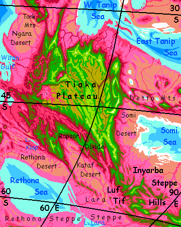
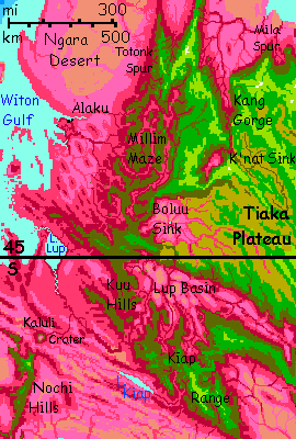
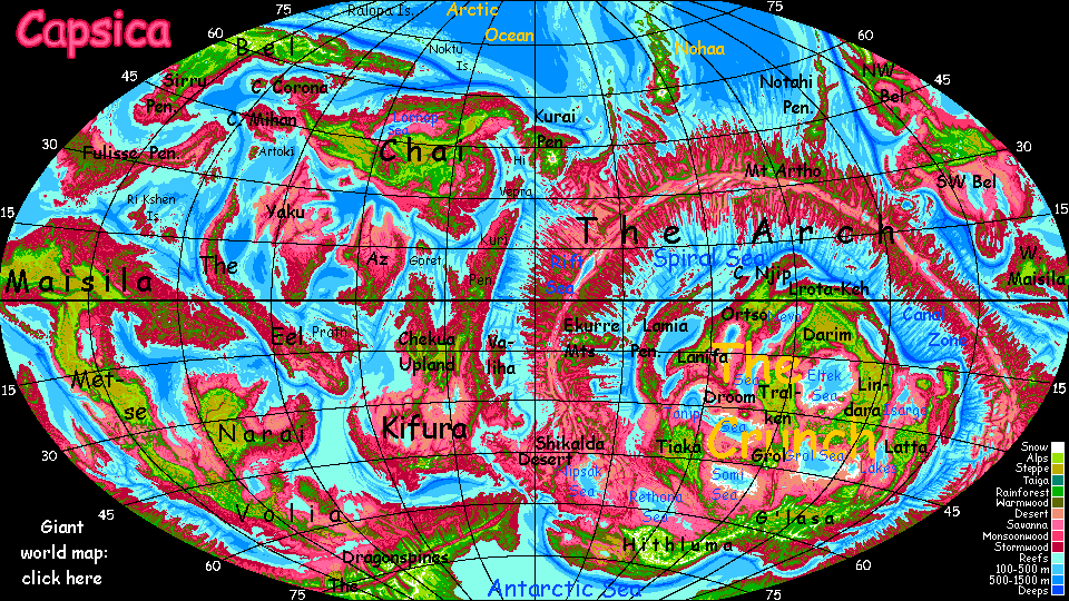
The Tiaka Plateau is a big, relatively isolated highland in the southwest Crunch. It resembles our Tibet in scale and origin: two plates under pressure have overlapped and stacked. Cut off by mountains from the sea, the region's lowlands are mostly desert. Sparse rain falls mostly in the highlands; even there, trees grow only along watercourses. The highland isn't as cold as Tibet, hence not as barren, though large animal life is rather sparse.
But it's not just life struggling to survive here. What's dying is the land itself. The plate's slowly being corrugated under terrible pressure from the Arch Rift; squeezed into nonexistence. The nearest equivalent on Earth is our Mediterranean Basin, a twisted, tortured, tiny remnant of the once-wide Tethys Sea. In deep time, our Mediterranean Sea's now intermittent; it's dried up before, and likely will again, unless our current meltdown turns permanent, raising sea levels so high the Mediterranean can't get cut off. But a few million years ago it was a fiercely hot desert basin quite like Tiaka's lowlands. It's just that Capsica's lower, smaller seas, with no icecaps to melt and top them off, will never flood the region; what you see is what you get. Except in deep time; it'll shrink and get even more rugged as it all... accordions.
Is it all dry? No. Ringing the plateau are small seas or big salt lakes resembling our Caspian; Rethona to the southwest, Grol to the southeast, Tanip to the northeast, and Witon Gulf to the northwest. Witon's the head of the Spiral Sea; it's the only one of the four seas with shipping routes to the wider world. So the northwest is materially and culturally richer than the rest.
The northern two basins are quite dry, but Rethona and Grol have southern shores near 60° south; steppes with lavender grasses, even woods along streams; food and water are still sparse, but more secure here. It's people in short supply.
Most of the year, the lowlands are hot even by Capsican standards, and fatal to Terrans much of the year--up to 65°C (149°F) in summer and 35-45°C (95-113°F) in winter. The extreme temperature swings of a desert climate actually give you a chance, in winter--sometimes. But generally you need to stick to the wooded ridges, where winters can get downright cold for Capsica: a mile or two up, 30°C (86°F) is common, and 20-25 not unheard of (68-76°F). You just won't meet many natives, not in that biting cold!
As with other tours, the low gravity and dense air make traveling local style advisable. I'll assume you've practiced with your strap-on wings and don't need a tutorial. We'll start in the south, at the west end of G'lasa Plateau and head up the Luf Tif Hills, then counterclockwise around the edges of Tiaka Plateau (the best updrafts are along the rim), noting the (many) flyways to other regions locals use, and the (rare) flyways safe for weak, clumsy fliers like you.
The region's pattern--barely tolerable plateau above hot, salty, dusty basins--will repeat all over the Crunch. It's a traffic jam of platelets and small sea-basins that just aren't quite big enough to rehumidify winds passing by; the heart of the Crunch isn't an unbroken desert like our Sahara, but Iran or Arabia are reasonable models--bordering seas, but still dry except high up. Such basins aren't pleasant, even for locals. For you, just fatal.
So Tiaka's marginal in all senses. Still, compared the the heart of the Crunch, it's cool, green and easy. You just won't think so.
Intro - Luf Tif Hills - East Rim - North Rim - West Rim - South Rim
You start out heading west from Tsal Mesa, a finger of G'lasa Upland, a subpolar plateau that's almost Terran. Long ridges west, into the Luf Tif Hills.
The locals call them hills, but most Terrans wouldn't; the highest peaks top 4.6 km high (over 15,000'); they're just scattered volcanic clusters, not an unbroken wall generating steady updrafts and a convenient flyway. Capsicans judge mountains less by height than consistency! Luf Tif is a perfectly good flyway--even humans can hop between its cool sky-islands--but it takes more work than many.
The whole archipelago of sky-islands feels like a transplanted patch of Terra; green plants, and few if any Capsicans in sight (or any animal life; migrated downslope); too cold for them now in winter. It gets as low as 25°C (77°F). Brr! To the locals.
The Lod Knot: high, actually cold. Peaks with snow streaks! Head along the north, sunnier face. Elsewhere on Capsica I'm always guiding tourists to the shady, cooler side; but this is winter two miles up at 60° south. If it gets too hot, just go up another mile.
On the Lara Steppe below, some tree-dotted savannas will support decent irrigated farming (if Capsicans are herbivores) or good grazing/ranching/hunting land (if carnivores). You have a rare opportunity to tour a working Capsican farm, though of course much will be dormant in this paralyzing cold. The enzymes powering rhodofers can handle oven heat (well, 75-80°C, 167-176°F), but turn sluggish down at 35°C. (95°F). Most plants subjected to such cold are annual, or deciduous. Death or hibernation.
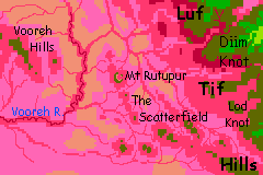
Volcanic cones a mile or two high dot this part of the Lara Plain--the Scatterfield, it's called. Old lava flows snake the plain.
North now, over a narrow gap--a saddle of lowland grasses, briefly lilac-colored from winter rains. They'll dry to pink again soon enough. These lowlands aren't lush--inside the Crunch, storms come off stunted little seas.
The Diim Knot: also high enough to be cold. Peaks with snow streaks again!
Round the west end. Below, the Kataf Desert. Rainshadowed by the Vooreh Hills far over the western horizon, this basin's steppe to outright desert. Pale pink now with dry grass, in winter, broken with bare rock outcrops of ochres and buffs----and lava flows, rust to black.
Lower ranges ahead in The Arc--just 3.7 to 4 km high (12-13,000')--not quite enough for snow, at least at the moment. Still cool, compared to the desert below--in this winter mild spell, 40-45°C (104-113°F).
Two or three days curving west then northwest along The Arc.
Then a straight, high ridge, slowly widening over the next couple of days--Luf Tif Spur, the first finger of Tiaka Plateau. Snowy heights topping 5 km (nearly 17,000'), chartreuse meadows and somber green woods on the mountain-shoulders, opening lower down (say 3 km up) to blond dry-grass steppe (less rain here, waist-high), and cliffs (analogous to our undersea continental rims) dropping to tan desert on the left--when you spiral up far enough to see through passes west. Stick to the east face of the Spur; that's where the updrafts are.
Intro - Luf Tif Hills - East Rim - North Rim - West Rim - South Rim
As the Luf Tif Spur merges with Tiaka Plateau, the steppe below, to the east, fades from lavender (marking spring green on Earth) to pale pink (the hue of dry grass). Out past the horizon is the Somi Sea, saltier than the world-sea; it's ringed by salt flats. Dust storms off these are as common as rain off the sea.
Two days north. Winds from the east hit this eastern rim of the plateau; steady updrafts ridable all day. Little creeks drop in cascades down the slopes, a few of the many arms of the Zeirab River--sandbars, hazel shallows, red tree borders, winding through lilac lowlands; the salt-flat shores of Somi are farther away here, a good 400 km (250 mi), so windblown salt doesn't desiccate the grass, and light rains aren't rare in winter, though too sparse for trees away from creeks. In drier times, the sea recedes until the Zeirab is twice as long (if even shallower); even now, the channel's visible from low orbit, a blue snake-canyon in the shallow turquoise sea. But not from here. Just steppes to the horizon. You might as well be on Asia's old Silk Road.
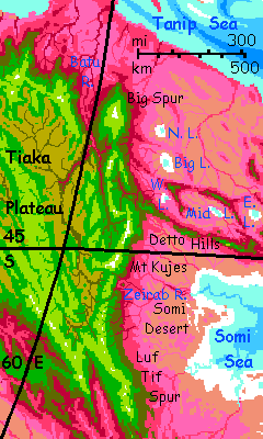
Ahead, a great snowy peak, Mt Kujes, 7.6 km high (25,000'). We're nearing 45° south, where it takes a giant to hold snow, even in winter. Forest-flanked in this mostly treeless land. A comfortable camp for once--on Kujes's shoulder, still 3 km below the summit (c.15,000'), it's just 25°C (77°:F).
A day or two north, as the white tent pavilion recedes behind us til it floats above the horizon; all but the snow gauzed in haze.
A long broken spur thrusts east: the Detto Hills. These run out of sight, all the way to Grol Upland in the Central Crunch. The Dettos divide the Somi Basin we've been skirting from the larger Tanip Basin to the north. And northeast. And northwest.
At the Dettos' feet on the north side, shallow brackish lakes, two of them visible over the next two days as we pass--West Detto Lake, then Big Lake. These basins are cut off by more sky-islands to the north, crowned in sparse red and olive woods, cutting off any view of the Tanip Sea.
Just as North Lake starts to show over a low spur, it's time to leave the East Rim; ahead is only Big Spur, a massive keel rising from savanna and desert--and a dead-end we'd have to backtrack from. Even from three miles up, you can't see the Tanip Sea, it's still 400 km off (250 mi)--just a few clouds suggesting the steppe and desert does end in something... wetter. If not much rainier. Tanip lies around 30° south, a terrible latitude for a continental interior. Air heated at the equator descends here, wrung of all its moisture.
Narrow little Tanip, a mini-Mediterranean, does its best to remedy that, but it's regrettably like Earth's Persian Gulf. Because it stretches thousands of km, not hundreds, it partly succeeds; all that heat and evaporation does recharge the air enough for rains on these highlands, and even, sparsely, on the foothills--the spiderweb of creeks below the escarpment are lined in red trees. But this is its best face; overall, Tanip Basin rivals Eltek (to its northeast) as Capsica's barrenest.
So let's skip it. Jag sharply west, "inland" over Big Detto Pass. You have to climb above 4.5 km (near 15,000'), and the air gets thin, but the wind's at your back, lifting you over. It's cold--not Earth cold, not even Kujes cold, but 25-30°C (77-86°F)...
Intro - Luf Tif Hills - East Rim - North Rim West Rim - South Rim
Down from Big Detto Pass to the east fork of Batu Gorge. Dramatic falls up to 300 meters (1,000'); sheer cliffs up 2200 m (7200'); deepest point, 3.7 km (12,000!). Trees only in the highlands, on streambanks and in spray zones; the Tanip Basin's not rainy. Heart of the Crunch.
North along the west wall of the gorge a full day. Across the abyss, to the northeast, the heights of Big Spur get very high indeed--8 km (26,000'!) Snowcapped now, if not for long; the last snow we'll see for a while.
North by west for us, instead. For now. The east rim was fairly straight; the north rim's ragged, all promontories, gorges and coves.
After a day, we round the next, Suta Spur, a cliffwalled thumb 65 km long above the coils of the lower Batu River. Round the tip, Suta Cove; the grassy plateau drops precipitously into a dusty rose void. The savanna's so far below it's hazy. Every few miles, a slender waterfall feeds another red col of heat-tolerant ferns--vertical oases. The cliffs of Suta snag sparse rains off the Tanip Sea.
Not lush, but not bad by Crunch standards.
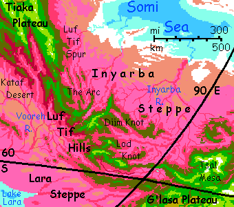
Bigger but lower Dua Spur--here a lower ridge, just 3000 meters (10,000'), barely up in the olive zone, extends farther north. You can cut across the base of it, straight west, sticking to higher, cooler, greener ground.
Gita Spur--longer and higher. Follow this one out to its tip. It's 200 km (125 mi) long, so even on the wing we're wasting a day. Why'd I bring you all the way out here? Only from the rocky tip of Gita Promontory can you see the Tanip Sea--and this stretch, the south shore of the West Tanip, is about the best it has to offer. Not pink savanna but leopard-spotted land--plum woods and lavender meadows down to a turquoise sea--no salt flats along the shore, unlike must of Tanip's coast. More Caspian than Aral! You can see farmhouses down there. Hot even for Capsica, but not a bad life, raising green figs and gold melons (the colors contrast with red and plum foliage, to attract animals to spread the seed, just as Earth fruits tend not to stay green. To reproduce, stand out!)
Southwest across the base of similar but lower, smaller Tapma Spur.
Mila Spur--a substantial ridge you'll have to follow north, for it's too high to cross easily--a buttress of Mt Mila, 6.5 km high (21,400'), snowy now in winter.
South for two days up Kang Gorge! This great canyon is at first 50 km wide (30 mi) and three deep (2 mi); the strata in the canyon walls look like brickwork. Successive lava flows, 'traps' as Earth geologists call them, of different temperatures, chemistry and strengths cause fractures leaving this brick-wall, brick-stair look.
By next day, we skim along the rim of The Narrows, just 3-5 km across (2-3 mi)--little wider than it is deep (3.7 km, or 12,000'). A Zion Canyon of brick...
At the head, it widens again into a strange cliffwalled box canyon, like a titanic lava plug in reverse: the strange K'nat Sink. In wetter country, it'd be a lake basin or tiny sea. Not here. Either a caldera full of lava suddenly subsided or some catastrophic flood scoured this out, but it's a puzzle what could do it on this scale.
Here for the first time, you have real choice: a couple of flyways ahead are high, cool and continuous enough for tourists.
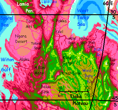
However, the clouds on the horizon hint it's just a local sag, and that's true. Spiral up the thermals high enough to glide and flap, glide and flap across the 100-km gap, and you'd reach the cool volcanic highlands of the Tonk Range. Beyond, the climate turns equatorial, rainy even at sea level: the vast, jungly Lamia Peninsula.
Intro - Luf Tif Hills - East Rim - North Rim - West Rim South Rim
The Ngara Desert sprawls below. Despite the dry plain, towns along the rivers are prosperous, for barges can take local products down to the Spiral Sea, and it alone, of the dozen seas in the Crunch, is an arm of the world-sea. Shipping routes are long and convoluted on Capsica--land barriers all over--but at least they aren't caravans! Once you've loaded your catamaran, the wind does most of the work.
As you head south, the desert slowly blushes pink, then lilac. Clouds clutter the clear desert sky. More and bigger winding streams with red banks: tall trees. You're heading out of the latitude of Cairo to that of Athens, or Los Angeles to San Francisco. Prevailing winds here bring more and more rain off the sea. Forests grow--at first in the highlands around you, then down the slopes, blushing red.
By next day the stark plateau-rim breaks up into a broad tangle of green hills and olive to red canyons, all solidly wooded: the Millim Maze. Most highly dissected landscapes on Capsica, as on Earth, are in zones with hard brief rains--monsoons, or thunderstorms--where vegetation can't anchor the soil. Here though, it's a temperate rainforest; erosion alone probably can't explain these canyons doubling back on themself. Tiaka Plateau has a lot of strange nicks and holes--oversize gorges like Batu and Kang, huge sinkholes like K'nat and Boluu. Whatever subsidence or catastrophic flooding that caused them seems to have been half-operating here too. The plates of the Crunch are old; it's a pile-up of once-broad regions slammed and stacked by the Arch's spreading rift. Tiaka may have been in a very wet zone once, and still bears the scars.
On Earth, a labyrinth like Millim would be sparsely settled and probably poor; transport and communication are hard when every road involves scaling miles-high walls. On Capsica, wings make all the difference; every windy ridge is a highway. True, perishable foods can't be exported in your arms, but tools, books, crafts and gems can; and barges with dried produce and lumber can take their time winding down the rivers to Alaku on the Millim delta. And this is Witon Gulf, an arm of the world-sea, not one more cut-off Caspian like most in the Crunch. So for the Crunch, the Millim labyrinth is up-to-date and prosperous.
Three days meandering south through Millim, sticking to the cool green heights, peering down at terraced slopes full of red orchards with blue, gold and green (ripe!) fruit. Like a photographic negative.
Skirt the rim of Boluu Sink, a basin the size of Utah with no outlet. Dry grasslands dropping in giant terraces down to the brackish soapy little lake at its heart--its private ocean. The story of the Crunch writ small!
Intro - Luf Tif Hills - East Rim - North Rim - West Rim - South Rim
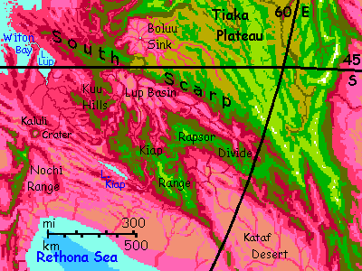
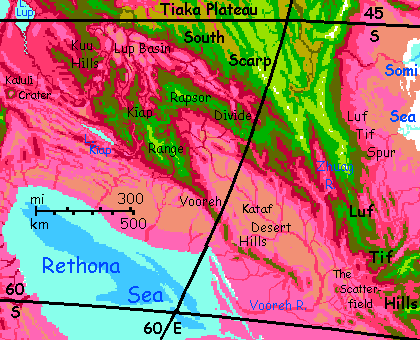
Another day south. The southwest corner of Tiaka now, where it ends on a long straight fault--the Southern Scarp.
Here you have several choices:
Broad stretches of the Kuu Hills are about 3 km up (10,000'), but too rolling and dissected to consider a plateau--a lobe of Tiaka. And unlike most of Tiaka, it's green wooded country--storms off Witon Gulf keep it fresh year-round. It's 30-35°C (86-95°F); almost like some Terran tropical highland, say Ethiopia or New Guinea, during a heatwave (in deep winter, at 45-48° from the equator). Still, the heat's it's bearable, since you can land and rest in green shade whenever you're tired, and easily find creeks to swim in and cool off.
South and a bit east a full day. A sunset, camp at the lip of a dim purple abyss--Lup Gorge. Here the river draining all of Tiaka's south side breaks through an encircling wall of hills.
In the morning you cross this great gulf. The Lup River doesn't look like much from up here; a winding brown-gold snake, clearly shallow; for storms drop most of their rain on this outer wall, leaving the Lup Basin dry, mostly savanna and even desert, with trees only along streams from the highlands.
South a day through the foothills of the Kiap Range. A bit drier, fewer clouds blocking long views, but still wooded. Near dusk the green world just ends: a vast slope down to a turquoise sheet, long Lake Kiap. Just ten miles wide, but it stretches to the horizon east and west. Beyond the low red-wooded ridges on its far shore, pale violet plains--savanna again. We've been heading away from Witon Gulf, the last gasp of the Spiral Sea, back into the dry vastness of the Crunch. The lake is the last that drains to the world ocean; all Caspians from here on.
Northwest into the heart of the Kiap Mountains.
The next day, a white triangle ahead: snow! Mount Noon, a volcanic peak 5.6 km high (18,400'); biggest in the south.
Here we must choose a way to skirt the Kataf Desert.
The easier route back: ride the winds northeast through the cool, comfortable Kiap Mountains, then above the high, unbroken ridges of Rapsor Divide, then down the Zhuag Hills and across the mouth of Zhuag Valley, back to The Arc in the northern Luf Tif Hills, where we started.
Or... the difficult direct route. Head southeast along the scattered volcanic summits of the Vooreh Hills. Desert and savanna below...
Coral and brilliant fish! This subpolar sea's actually cool enough to have evolved some limited analogs to Earth coral. One of very few beside the Arctic and Antarctic. They're all endemic to Rethona; it hasn't been a lobe of the world ocean for at least ten million years. Though it's the only one not cut off by high mountains, hence the only one I'm confident was connected long ago. So, just modest variations on Capsican sea life. But some of the other cut-off Caspians... do they hide krakens? merfolk? I'm not sure, and even the locals may not know; some of those little seas are so salty they're caustic, wrecking wooden boats (and fisher's hands) in a single season. Places like that get shunned.
On down the Vooreh Chain. It straggles nearly due east now.
Two days later, when it fails, push on east over the lilac flats paling to dry pink. Even the grass finds it hard to live out here.
80 km out (50 mi), there's a solitary volcanic cone, just 2.4 km high (8000'), to camp on. You need to make it this far, sleep early and get a predawn start. You're crossing the dangerous lowland of the lower Vooreh River. It's 160 km (100 mi) to the next peak on the far side--scattered volcanoes dot the plain, though not a neat chain; it's called the Scatterfield. This far polewards--you're nearing 60°: south--even cones a mere two km high (6600') still poke into the olive zone--enough to be safe in winter. If not comfortable.
Next day you reach a massive broken caldera, Mount Rutupur, 20 km wide and 3.5 high (11,500'). The northeast wall collapsed so there's no crater lake, but you find green trees and springs on its Rutupur's high rim. Rest, cool off, sit in a creek. No, not that hot spring. Sorry.
Another day southeast along a line of lesser olive-tipped peaks, then one day east through taller green cones--the Scatterfield's a good 800 km wide--and at last you see white streaks ahead: late winter snow on the high, cool peaks of Lod Knot in the Luf Tif Hills, where you began, a long hot winter and 6000 km ago.
And Tiaka's just one small corner of the Crunch.
World Dream Bank homepage - Art gallery - New stuff - Introductory sampler, best dreams, best art - On dreamwork - Books
Indexes: Subject - Author - Date - Names - Places - Art media/styles
Titles: A - B - C - D - E - F - G - H - IJ - KL - M - NO - PQ - R - Sa-Sk - Sl-Sz - T - UV - WXYZ
Email: wdreamb@yahoo.com - Catalog of art, books, CDs - Behind the Curtain: FAQs, bio, site map - Kindred sites