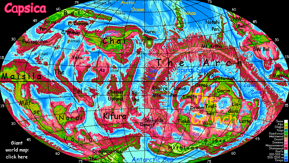
Capsica's homepage, map, giant ref map, geography, gazetteer . More worlds? Planetocopia!
 Capsica: The Tsingri Desert
by Chris Wayan, 2023-5
Capsica: The Tsingri Desert
by Chris Wayan, 2023-5
Introduction - North: Tsekeni Highlands - Central: Espili Basin - South: Nochi Hills
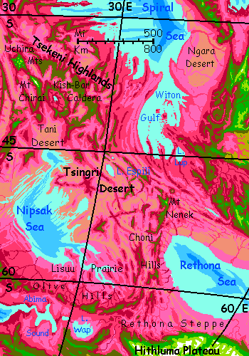
The Tsingri Desert is both a drying and dying zone. The drying is obvious. Cut off by mountains from the sea, the region's lowlands are dry shortgrass steppes fraying to true desert in many places. Rain, trees, and streams are generally found only in the highlands--mostly long washboard ridges, snaking north-south across the whole region.
But it's not just life struggling to survive here. What's dying is the land itself. Those ridges are symptoms. The land's slowly being corrugated under terrible pressure from the Arch Rift; squeezed into nonexistence. The nearest equivalent on Earth is our Mediterranean Basin, a twisted, tortured, tiny remnant of the once-wide Tethys Sea. In deep time, our Mediterranean Sea's now intermittent; it's dried up before, and likely will again, unless our current meltdown turns permanent, raising sea levels so high the Mediterranean can't get cut off. But a few million years ago it was a fiercely hot desert basin quite like the Tsingri. It's just that Capsica's lower, smaller seas, with no icecaps to melt and top them off, will never flood the Tsingri; what you see is what you get. Except in deep time; it'll shrink and get more rugged as it all... accordions.
This tour will be short and simple. Our route will cover some 2600 km (1600 mi) as the tourist flies, but by air that won't take long; and there are no branches, no options, no dilemmas, for only one route gets you safely through a desert hotter than any on Earth. Well, the flyway does have branches--for locals! But they can cross lowlands far too hot for you.
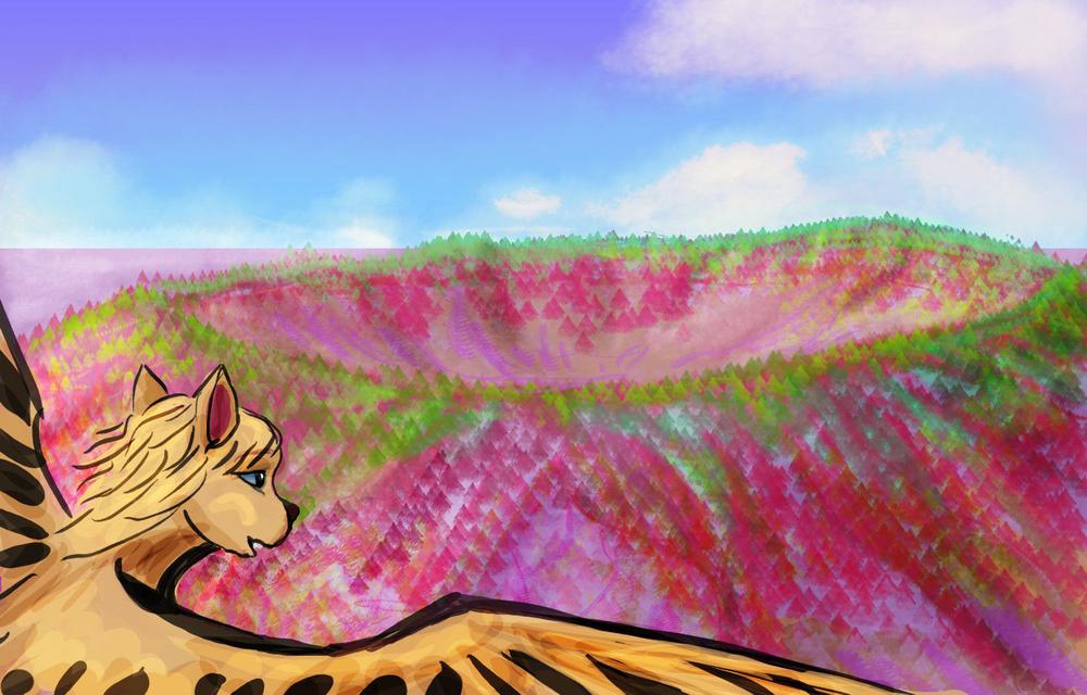
Rule of thumb in the Tsingri: if it's green, even olive, you'll find it hot but survivable. Red? Not. That color marks heat-adapted rhodofers.
Is it all dry? No. In the far southwest is the Nipsak Sea, a deep basin cupping a salt lake big as our Caspian; in the southeast, the Rethona Sea, just as big. Most of these two basins are dryish, but their southern shores are near 60° south; steppes with lavender grasses, even woods along streams.
Most of the year, the lowlands are hot even by Capsican standards, and fatal to Terrans much of the year--up to 65°C (149°F) in summer and 35-45°C (95-113°F) in winter. The extreme temperature swings of a desert climate actually give you a chance, in winter. Sometimes. But generally you need to stick to the wooded ridges, where winters can get downright cold for Capsica: a mile or two up, 30°C (86°F) is common, and 20-25 not unheard of (68-76°F). You just won't meet many natives, not in that biting cold!
So: a fast, fairly straight run-through--big, lonely vistas across a big, lonely land. We'll start in the north, head southeast past Lake Espili, angle south along the Nochi HIlls, until we reach the safer, greener, quite Terran highlands of Hithluma, flanking the Antarctic Sea.
The Tsingri Desert's pattern--low, hot, salty, dusty--will repeat all over the Crunch. It's a traffic jam of platelets and small sea-basins that just aren't quite big enough to rehumidify winds passing by; the heart of the Crunch isn't an unbroken desert like our Sahara, but Iran or Arabia are reasonable models--bordering seas, but still dry except high up. Such basins aren't pleasant, even for locals. For you, just fatal.
So Tsingri's marginal in all senses. Still, compared the the heart of the Crunch, it's cool, green and easy. Though you won't think so.
Intro - North: Tsekeni Highlands - Central: Espili Basin - South: Nochi Hills
I'll assume you're coming south along the Southwest Arch. HIgh ridges across the prevailing winds; you can ride the updrafts for days. So...
Late in the afternoon, you reach the Uchira Mountains. This highland is 185 km long, 110 wide (115 by 70 mi), mostly 4.2-4.8 km high (13,800-15,800'). The whole sky-island feels like a transplanted patch of Terra; green plants and few if any Capsicans in sight (or any animal life; migrated downslope); too cold for them now in winter--as low as 25°C (77°F). After your last few weeks that feels cold even to you. Below, the green heights still blush red, but with fewer white punctuation marks; clouds are growing rare. The red pales to pink--grassland not forest. The edge of the Tsingri Desert! The influence of the Spiral Sea far to the northeast is waning with every degree south...
All next day a white triangle ahead beckons you. This is Capsica, so it can't be snow, of course. But it is! We're not in the tropics now. Snow is (faintly) possible--given a giant. And Mt Chirai is. Most of its long ridge is like Uchira, 4-5 km high, but in the middle, one monstrous peak thrusts up 7.6 km (25,000')! You camp on its waist and drink actual cold water--snowmelt. Chirai may seem unearthly, a Himalayan peak arbitrarily rising from nowhere, but it has parallels on Earth; consider Minya Gonga or Namcha Barwa, Chinese Himalayan outliers of similar height--and over a mile above every peak for hundreds of kilometers.
Southeast of Chirai is a broad volcanic structure, Kish-Bar Caldera. Now this is unearthly--an oval 350 km long and 250 wide (220 by 150 mi); the crater wall averages 3.6 km high (nearly 12,000'), allowing no outlet for a small, pea-green, mineral-laden central lake. The rim is high enough for mixed green and red flora; cool enough for you to visit--now, at least. The outer slopes are mostly rainy and forested; the interior, with storms blocked, is drier. Oddly, the caldera floor isn't too dry, though you'd expect severe rainshadowing; but it's built quite high up, barely a km below the rim. Climatically it's almost a plateau. Maybe Kish-Bar is on its way to become a true shield volcano like the Ekurre Range to the north. Preferably not soon! While it's busy doing so, the whole region will be unlivable. Still, it's possible Mt Chirai isn't the outlier it seems--if you take the long view.
Some of the Capsicans on your flyway veer east here into the olive Witon Hills, on their way to the Lamia Peninsula in the Crunch. Don't follow. While extensive, the hills lower and spread into Witon Peninsula, a broad rolling savanna full of sunheated updrafts you could follow--but with no cool heights to camp on for hundreds of km. And it gets even worse on the far side of Witon Strait--the Ngara Desert's another 6-700 km of arid flats (over 400 mi) before you'd find a sky-island you could bear. And not just you; even the locals find this a hot, dreary thousand kilometers. But they can rest, breaking the ordeal into a few days; you'd have to fly it all nonstop.
Stick southeast along the ridges of Tsekeni Highlands, also 3-4 km high. After the first day, there are gaps between scattered green volcanic heights and dusty-pink lowlands; but none over 80 km (50 mi), which you can cross on the wing in an hour or two. Due south, the pink pales and browns as even grass gives up; the Tani Desert, a dead flat stretching hundreds of km south to an arm of the Nipsak Sea.
Strange to be spending just a page or two on a region several times the size of France, with a sea as big as our Caspian...
When I first planned this tour around 2021, I thought the basin was unvisitable--it's mostly hot desert or grasslands--the relatively gentle terrain is a disadvantage for you; no land high and cool enough.
Now in 2023 I'm rethinking this. The Crunch is like our Central Asia; Siberian summers are hot and winters famously cold. Capsica's denser air evens temperature swings out some, and so does the presence of the Nipsak Sea; but even if they add ten degrees to winter lows, the basin is quite high latitude, and should get as cool as 30°C (86°F); tourable after all, in winter.
Trouble is, I'm not sure I want to. It's not just flat and dry; irritating, desiccating dust off the deserts and saltflats aren't much fun. There's just too much land surrounding the Nipsak Basin, and too little sea; it hardly matters what winds blow when they're all pretty dry--wrung out by previous mountain walls, they have little left to give.
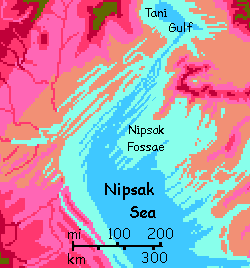
The northwestern Nipsak and the central sea floor are... odd. A washboard of low narrow ridges and troughs called fossae; neither dunes nor stream-eroded, they're a much finer-grained variant on the ridges flanking most of the Rift. Some fossae run hundreds of kilometers.
I'm not sure why the crust here's corrugated like bits of Australia or Appalachia; those are old, eroded remnants, the roots of long-ago Himalayas. But Nipsak's crust, not far from the spreading zone of the Rift, must be fairly young. Were the Nipsak Fossae perhaps laid down as seafloor features in some opposite of our Ice Age--a Steam Age, a few degrees hotter, so storms were fiercer, rains more common, and the Nipsak Sea a bit higher? After all, disconnected from the world-sea, its level is quite unstable.
But I just can't call it chance that these corrugations are perfectly parallel to the Rift. More likely an uncommon response to compression, then. As that great Russian geologist Tolstoy once wrote, "Happy tectonic plates are all alike, but each stressed-out plate crumples in its own way."
Such fossae aren't unique; the Isle of Goret and the Ri Kshen Isles have them too.
Nipsak's plains do vary--on the east and south shores especially, below the Olive Hills and on the Lisuu Steppe, some tree-dotted savannas will support decent irrigated farming (if Capsicans are herbivores) or good grazing/ranching/hunting land (if carnivores). You have a rare opportunity to tour a working Capsican farm, though of course much will be dormant in this paralyzing cold. The enzymes powering rhodofers can handle oven heat (well, 75-80°C, 167-176°F), but turn sluggish down at 35°C. (95°F). Most plants subjected to such cold are annual, or deciduous. Death or hibernation.
Intro - North: Tsekeni Highlands - Central: Espili Basin - South: Nochi Hills
Two long days southeast along the Tsekeli Range. Ridges and volcanos, not continuous but with easily crossable gaps.
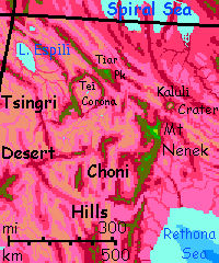
To the south, Lake Espili gleams. This oval blue eye, 135 km long and 65 wide (85 by 40 mi), most resembles Issyk Kul (Lake Alexander) in central Asia. It has no outlet; not salty enough to poison its shoreline, but brackish to the taste. Wait, can you? We're now past 45° south, in winter, in a continental climate. On Earth it'd be below freezing; Capsica's denser air moderates that effect some, and the lake itself stabilizes temperatures too, so it drops only to 35°C (95°F). Survivable! Down you swoop, past fields irrigated by creeks off the heighs, to find swimmable beaches (though the water won't cool you much). No Capsicans around; they're huddling in cabins, bundled up. You can even camp here tonight; it drops to 30°C (86°F) by midnight. Brr!
Once the fields warm up in the morning, generating updrafts, you spiral back up to the main Tsekeni Ridge, on the northeast side of the lake. Follow it all day to Tei Corona. You'll know it--the ridge suddenly forks. Green highlands run both northeast and due south. You've slammed into the rim of a roughly circular structure, apparently not a caldera nor a Terran anticline but a magma-blister that changed its mind and either popped or sagged back down, leaving a stony bathtub ring two miles tall. Such formations are rare on Earth (one tentative candidate's in southwest Mongolia) but they're common on Venus, and infrequent but not exotic on Capsica. Cut off from rain, the interior's hot sandy desert with a small, salty sump in the center.
Because the rim curves, going nowhere, such coronae aren't popular with Capsicans; flyways understandly favor straight(ish) ridges.
The righthand rim-path is in the right direction, but not recommended. For the first 200 km south it's easy--green Terran highlands, temperatures in the low 30s (85-90°F). But once you leave Tei Corona, the desert ridges sag--summits still wooded, but red--well under 2 km--and stay low for hundreds of km. Nowhere cool enough for you to rest.
To the left, northeast, is less direct, but higher, with smaller lowland gaps. Follow the ridge, and by noon a faint pale triangle ahead will come clear, still 100 km off: Tiar Peak, a great triangular massif some 6.1 km high (20,000'). The summit is a wedge of pale chartreuse with just a few small streaks of white. Not quite as vivid a beacon as a snowcap, but distinctive enough in this world of reds and sober greens. It's a fern-fell, an alpine meadow above the treeline (well below the snowline; Capsican trees, even the green ones, are frost-delicate). Occasional winter snows are enough to keep the peak bare except for specialized annual herbs and ferns.
At sunset you reach Tiar's immense flank. Camp on the shadier south shoulder; as the sun sets, it's just 25°C (77°F).
An hour after dawn, the northeast foothills of Mt Tiar heat to 35-40°C (95-104°F), while up here it's barely risen from 15 to 20 (59 to 68°F). (I know these travelogs make it seem like Capsica is monotonous--just hot and hotter--but its temperature variations are only modestly less than Earth's.) That huge difference powers great updrafts. You launch off the mountainside, get well away, and that rising wind hits you like a bucking horse--one you'll ride all day. Two miles below you, wings flicker in the slanting dawnlight. Capsicans are doing the same, down where they won't get hypothermia while riding a winter flyway. So near yet so thermally far...
All day east and a bit south along the front. Camp at 3800 meters (12,500') on a freestanding green pyramid. Trees, shade, a tiny rill, and only pleasantly warm. Therefore empty of locals.
At sunrise, two peaks burn green ahead of you, in a sea of pink dry grass, lurid in dawn. One's due east, a strange broad mesa about your height; the other, southeast, is a giant on the Himalayan scale of Mt Chirai, not just streaked but capped in snow.
Let's waste a few hours on a detour to that lesser peak. I think it's worth it. By noon, you're on its shoulders, finding its winds oddly tricky. Up to the mesa rim... and it's no mesa. Cliffs drop into a great caldera--Kaluli Crater, 25 km across and 3 deep (15 mi wide, 2 deep). Like Oregon's Crater Lake, ancient Mt Kaluli collapsed into its own vent. But it's desert down there; no central lake. Far as I can tell, it's because this particular volcano spewed cinders more often than solid flows; it's porous down there, and the limited runoff from the rim sinks deep.
Capsicans camp lower down the slopes--you see smoke from their campfires. They're not here for scenery--they're heading east into the Crunch from here. Rolling pink-grass lowlands sprawl to the horizon, and far beyond. Not you; it's at least 3-400 km (200-250 mi) to the nearest tolerable highland, the west rim of Tiaka Plateau. Kaluli is as far east as you can go.
Our way lies south--and so it will for the rest of this journey. It's not just us, it's the mountains--a sharp elbow. Like the twisted chains in the Mediterranean, as land gets squeezed, once straight lines can kink. It's not chance that giants like Mts Tiar and Nenek rise here (and former giants; even in ruin, Kaluli reaches 4.5 km; extrapolating its slopelines to the original peak, it was likely even taller than Tiar).
South to Mt Nenek! The snowiest we'll see on this trip. Nearly as tall as Mt Chirai, 7.4 km (24,100'), and we're 12° closer to the pole. The south face has the only glacier in thousands of km. It's unimposing, just a snow patch in a hanging valley that rarely sees sun; Capsica hasn't had an ice age, so the glaciers never crept down to sculpt the slopes--no horns or cirques. Maybe in the polar zones...
Intro - North: Tsekeni Highlands - Central: Espili Basin - South: Nochi Hills
From Mt Nenek, we ride the updrafts south along the Nochi Hills, sticking (as much as possible) to the east front; the highest, with the fewest gaps. Still some, but by now, you can handle gulfs 50 or even 80 km wide (30-50 mi), often more than three deep (2 mi). It's a good 125 km (750 mi) to Hithluma Plateau, less than a week on the wing if you push. Relatively uneventful. On your left, the plains of the Rethona Basin, from dusty brown desert flats to (increasingly as you go south) pink and then lavender ('greener') grasslands.
On the other wing--the west (right) side of the Nochi front--the rainshadow continues; gold, tan, dun, brick hills above winding black lava tongues.
A couple of days out from Nenek, at 57° south, you'll see a heat-shimmer out on those flats, at the horizon. Not a mirage; that's the Rethona Sea. You can't get much nearer; we're in an unseasonable mild spell, and the shores below are at 45-50°C (113-122°F).
But heat isn't rain. We're entering a generally wetter zone, and soon your cool green ridge parts seas of lush lilac grass on both sides: Rethona Steppe on the left, Lisuu Prairie on the right. Both directions, open water's no more than 200 km away.
The Nochi Hills start to curve off to the right. Slow and subtle, but over the day it becomes clear it'll soon be time to leave them; they're veering west to become the long Olive Hills, leading you to the Arch and the Outer Hemisphere.
Hop south. Sky islands, 2-3 km high, lower than most of the Nochi front, but cool enough to camp on, now that we're past 60° south.
A long day of jumping across valleys to modest, olive-capped hills. To an old hand on Capsica, the ruddy look of the land spells danger, but the color reflects the annual average. Here near the pole, in early spring, the sun's lost its scorch after that brief heatwave; now it's mild, just 35-40 °C down on the flats (95-104°F) and 25-30 up in the hills (77-86°F). It's as if you've been sailing Polynesia, navigating between habitable islets for years, until one day the sea's siphoned away, leaving vast lands in every direction. And no way to choose--a lifetime's intuition suddenly useless.
Well, poles often disorient explorers.
Ahead, a jawbone of giant white teeth heaves over the horizon: honest-to-god frozen water covering Himalayan peaks that cradle the Antarctic plateau of Hithluma. Brr! Might as well be Earth.
World Dream Bank homepage - Art gallery - New stuff - Introductory sampler, best dreams, best art - On dreamwork - Books
Indexes: Subject - Author - Date - Names - Places - Art media/styles
Titles: A - B - C - D - E - F - G - H - IJ - KL - M - NO - PQ - R - Sa-Sk - Sl-Sz - T - UV - WXYZ
Email: wdreamb@yahoo.com - Catalog of art, books, CDs - Behind the Curtain: FAQs, bio, site map - Kindred sites