Capsica's homepage, map, giant ref map, geography, gazetteer . More worlds? Planetocopia!
 Capsica: Volia
by Chris Wayan, 2023
This one's for you readers, who pestered me until I had to build it
Capsica: Volia
by Chris Wayan, 2023
This one's for you readers, who pestered me until I had to build it
Introduction - Intro - Touring - North - West - East - South
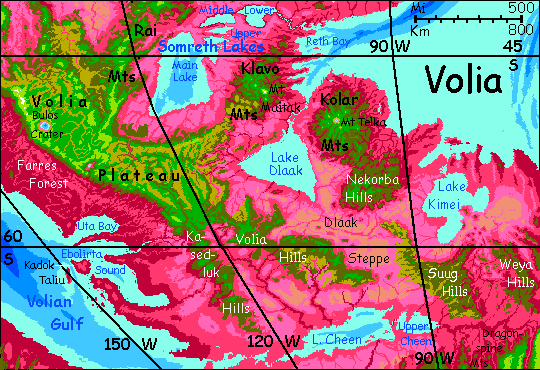
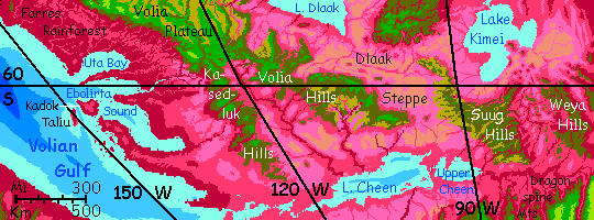
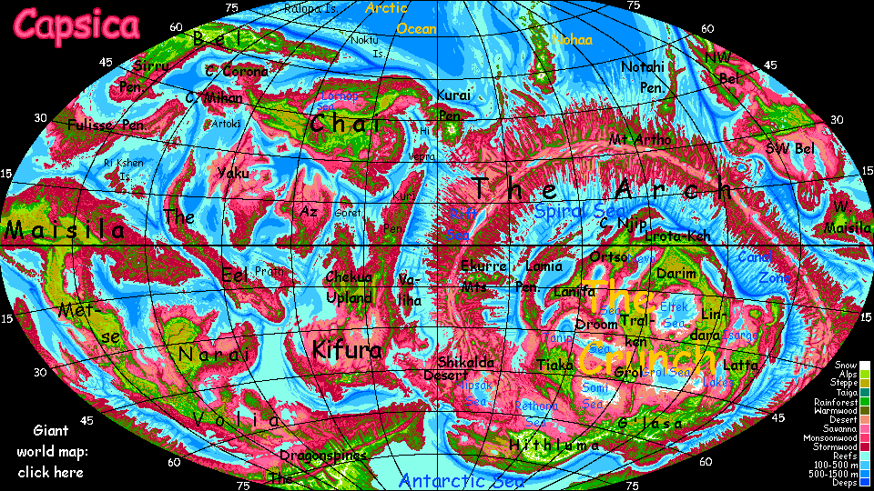
Volia is the Australia-sized base of the pseudo-continent of Maisila--"pseudo" because it in turn is just an Africa-sized lobe of Capsica's world-girdling landmass. Of course if these geological structures were on watery Earth not drier Capsica, most of it would be sea floor. The Volia Plateau would be an island the size of Greenland, the Rai Mountains a sort of high-latitude Java, with a few Icelands or Irelands scattered south and east. These uplands are quite high, 4-8 km (13-26,000'), rising into air cool enough for Terrans to visit (marked by predominantly green vegetation). But as Capsican regions go, it's mostly lowland (plants predominantly red).
Luckily, Volia is high-latitude, so even modest heights are bearable in winter.
Ecologically and culturally, Volia is more isthmus than continent, at least the highlands. The lowlands, especially the great prairies and lake basins in the east, are another world--fertile despite the harsh winters (down to 25-30°C or 77-86°F), well-populated, but with no world-class flyways and thus a cultural backwater. The closest analogies on Earth are America's Great Lakes or Eurasia's Black Sea/Caspian Sea basins.
Volia stretches from 42-70° south; its lowlands, wet or dry, summer or winter, are mild to cold for Capsicans; for Terrans, the highlands are comfortable in winter and bearable year-round; even some bits of the lowlands are accessible in winter, unusual for Capsica. Luckily, the north, closest to the equator and normal Capsican heat, is dramatically vertical too; the Volia Plateau resembles a greener Tibet or Altiplano, 3-4 km high (10-13,000'); peaks in the Rai Range top 8 km (26,000'). The highest peaks are snowcapped much of the year, though no glaciers have formed.
Capsica has low gravity and dense air; in rented strap-on wings, humans can fly. Just not like the locals! You're clumsy, underpowered, and inexperienced. Treat advice accordingly; translate "easy" as "challenging" and "hard" as "fatal". Still, if you ride thermals more than use your feeble muscle power, you can go several hundred km (say 200 mi) a day. And you can soar as high as 5 kilometers (16,500'), where the air's actually cool, and thins to just 1.4 Earth atmospheres (of course on poor high-grav Earth these wings'd be useless at any height). At 3-4 km up in winter, it's warm but pleasant; at 2 km, the heat is... bearable.
The natives find that barely-tolerable heat painfully cold. The heights have no cities, and only the smallest of towns--often no more than an inn every hour or so. Yet you'll meet plenty of Capsicans, bundled up and shivering. Fellow tourists there for the spectacular views, yes, but also business travelers. Why are they up here? Most Capsicans fly; they're riding the updrafts generated by the mountains. These form long flyways through Volia--and well beyond.
The main flyways form a great Y shape. The Rai Mts are a highway from the Narai Peninsula and the small continents beyond--The Eel, Yaku and Az, even distant Chai. The Rai Range meets the northwest-southeast sweep of the Volia Plateau, bringing travelers from Metse and equatorial Maisila.
Our tour will follow them, at least in a general way--down the Rai Mts, then around the northwestern Volia Plateau, then east into the lowlands, then south to exit the region by soaring up the Dragonspine Range into green, almost Earthlike Antarctica.
Southwest along the Rai Mountains. As high as 7.3 km (24,000'). We're finally, unmistakably out of the subtropics. Snowcaps on many of these peaks, not just streaks--even on ones no more than 6 km tall!
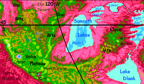
Day 2: an unusually clear spell. Head east onto Somreth Spur, a ridge just waist-high to Rai's heights--barely 4.3 km (14,000'). That pale blue to the southeast, 110 km (70 mi) away, is not the sea but Lake Somreth, a freshwater lake bigger than Lakes Michigan and Huron combined (oh wait--they are. Same water level, unlike Superior, Ontario or Erie. Biggest freshwater lake in the world--just unacknowledged.) The Somreth Basin is a vast fertile land a bit like America's Great Lakes region--minus the snow of course. And bigger: the Somreth Lakes' total surface area is 50% more.
Those lowlands, though "cool-temperate" by Capsican standards, are usually still too hot for humans. But it's late winter, and the western shore of Main Lake is 1200 km from the sea (750 mi), with a continental climate--hot summers, cold winters. Right now it's just 35°C (95°F)--freezing to Capsicans, hot for you. Down you go! A falcon-dive two miles deep; you hit 130 kph (80 mph), screaming all the way. The wooded slope beneath you turns olive, then red. Land on the scorching beach. Dive in! The water won't cool you much--it retains some of its summer heat, and is nearly blood-warm. But alternating swims and rests under the trees, cooled by evaporation, you actually enjoy a day in Capsica's lowlands. Rare.
Day 3: on south along Somreth Spur toward the Rai Mountains; prevailing winds slam into the Spur's east face and rise; an easy if rather hot day. You camp near the base of the Spur where it joins the higher Rai range.
Day 4: ride the east-face Rai Flyway south. Below, foothills and spurs, green and red, mostly cloudless at the moment. over the labyrinth of lakes, mountains, craters, and coronae of Volia. Capsica's seasons are shorter than Earth's, just 70 days; winter's half done. But that'll work out well to the south; as spring stalks you, you head into colder latitudes where it could almost be Earth.
Almost.
Day 5: over a difficult pass where another spur joins the Rais. Exhausting, for though you can breathe and the gravity's low, it's nearly impossible fly in air as thin as 1.6 Earth atmospheres. Down the far slope, and the way's clear the rest of the day--a massive green wall to the right, 6-8 km high; olive slopes down to rumpled red foothills to the left. You camp near a pass leading west--a jagged slash between hulking peaks. It doesn't look easy. Rest up.
Day 6: That pass, Rai Pass itself, is where the range ends and Volia Plateau begins. It's as high as the last, but not too hard--the prevailing winds are with you, lofting you forward and up. It's a hard slog for those coming the other way.
Day 7: west across Volia Plateau. Open highland, all golden grass--not that ubiquitous lavender-to-pink of Capsican lowland prairie, but cold-adapted grasses that could almost be savanna hills on Earth, except for the low gravity and all those Capsicans flapping by. Sinuous veins of green trees hide little creeks--the headwaters of the Rai River, flowing north to join the larger Elin, like the Blue and White Nile; together they flow another 1000 km of desert lowlands to Narai Gulf.
Day 8: West again. Follow the Vaa Hills between the Rai and Vaa basins. Tiresome flying--the air's not as bad as Rai Pass, but thin just the same; and no great updrafts. You flap along on your own muscle power. The Capsicans you see are mostly heading northwest into the next region, Metse. Follow them--though I plan to veer west off the flywa over the hills tomorrow. I have my reasons.
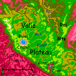
West over the hills and down to the canyon rim of the Vaa River at Second Cataract, where the river drops over 300 meters (1000'). There are plenty more falls to go--the Upper Vaa winds across Volia Plateau 3 km up (10,000'), then in a couple of hundred kilometers it drops to near sea level.
Gateway to Metse and equatorial Maisila--thousands of km of easy flight, riding updrafts along plateau rims. It's one of the safest routes to the equator for Terrans.
Southwest a day to Bulos Crater. It's the largest impact feature on Capsica; a crater 185 km wide (115 mi). Only 9 million years old, and thus far more prominent than Chicxulub on Earth. The outer wall rises over a km; central Lake Bulos is a deep blue eye 110 km across (70 mi). Set high on Volia Plateau amid green forests and meadows, the crater rim can be visited year-round by Terrans; shaded south slopes even get some winter snow. But in summer, the lake shores, 2-3 km below the rim, get dangerously hot--beware!
Despite its size, the Bulos impact didn't cause a worldwide mass extinction. On Earth, Chicxulub had four great effects: firestorms, tsunami, global winter (a year or more of night), and then a thousand-year heatwave, for the limestone of Yucatán is loaded with carbon, and cubic kilometers vaporized, greenhousing Earth, killing half the survivors. But Bulos hit an open plateau far from the sea; fewer forests to burn, a smaller tsunami trapped in broken-up seas. Global night for months, but not years; and no afterwave of heat and crazy weather. Pioneer plants moved in, and within a few million years, Volia looked about the same--if you ignore that hole.
Below the western rim of Bulos, a vast dropoff into a cloudy Amazonian abyss: Farres Rainforest. Don't even think about heading down there...
Southeast along the rim of Volia Plateau. Roraima with the vertical exaggerated. Updrafts and waterfalls, long white mares' tails blown right back up the cliff to fall again...
Kensu Valley. Earth's closest feature might be the Vale of Kashmir; Andean peaks around a much lower lake. Only here, the valley rim and slopes are comfortable, the lake dangerously hot; it drains via a narrow, deep, spectacular canyon where tree-ferns cling to ledges. Wild and lovely. Just stay up in the green zone.
Northeast two days over the lower, hotter eastern half of Volia Plateau.
In mid-afternoon a redrock gulf opens up, 25 km wide and 3 deep (15 mi, 10,000'), Somreth Gorge. A huge fall--from the green heights into the red. Though all half-hidden by white mist.
A broad washboard upland runs east-- the Degur Hills. Decent if patchy updrafts. Slowly, over two days, the jumble narrows...
At last, the Degurs sag lower. Lower. Soon you're no longer on the knees of mountains but teetering along a wave of air on their very summits. A full day through scrubby hills.
Hot camp, miserable sleep.
Relief! The Klavo Mountains. Alpine heights, Alpine cool. A day northeast. The Klavos break up into transverse east-west ridges. Not a barrier to you by now; in the morning, just cross a red valley, rest on a high cool ridgeline; after lunch cross a second valley, and camp on green heights at the hottest part of the day. Rinse (in a creek, to cool off) and repeat the next day...
This washboard country has an ecological effect. The Klavo and Degur Ranges were high enough to rainshadow the southern Somreth Basin. But these hills are a porous barrier; storms funnel right through these long valleys, feeding the lower Somreth Lakes, nourishing groves and scattered trees hundreds of km inland.
Locals can head on northeast right across the Somreth River toward the Narai Peninsula. You shouldn't; for hundreds of kilometers, the lower Somreth valley lacks heights safe for you.
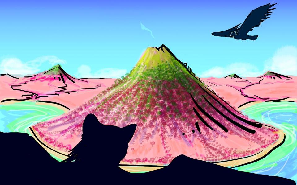
Instead you head southeast to giant Mt Maitak, a volcano 6.3 km high (20,700'). Scenic, cool, Terran. Rest up!
Next, south along a spur from hot olive hills 2 km high to fatally hot red-forested knolls just a mile high, and stretches of oven-hot lowlands. But don't lose faith in me. Real mountains appear ahead, green heights culminating in Mt Wakai, a stratovolcano 3600 meters high (11,800'). It rears right above the north shore of Lake Dlaak, tri-lobed and 5-600 km across; some 125,000 sq km (50,000 sq mi--like Lakes Michigan & Huron.) Blessed relief--just 35°C (95°F). Below you, this shore is all orchards and meadows; the southern, inland side is prairie, with a drier high-latitude continental climate. So some winter days there are cold enough for Terrans to visit--30-35°C (86-95°F). But don't go down to swim here--it's dangerously mild today; 45 (113°F), and the water won't cool you much; it's blood-warm. Another disadvantage of maritime climate!
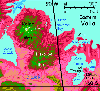
East another long hot haul to the Kolar Mts.
Humongous Mt Telka, a great Kilauea-style caldera 7.7 km high (25,300'). Yes, that white rim above you really is snow! The slopes are cool and green. Swing round to the warmer north side and camp in a green, Earthlike meadow on the shoulder, as high as you can fly--5.5 km. Impressive; all this flying over thin-air plateaus has toughened you up. Stash your wings in that grove by the snowbank; no one will steal them! Capsicans have elegant home-grown ones; your rented prosthetics are objects of mild embarrassment and secret hilarity. If there were any Capsicans here to snicker.
There aren't, of course. Capsicans fear snow--rightly, as they frost-burn at a touch.
Leave the wings, but bring that coat I insisted on. You'll need it at last.
Hike time! It's a long hard day (1100 meters, 3600' up) to the lowest spot on the rim, at 6.6 km (21,700'). At first, meadows and pinelike groves; some snow patches under the trees. Then mostly meadows and fern-fells, too exposed for snow to last. But we climb on. Snow in the lee of stones... mounting and spreading until, near the pass, you're tramping over snowbanks. This face of Telka tilts toward the sun, so much of the year it's snowfree, but this is a winter day; it's a frigid 10°C (50°F), about the coldest place I've ever taken tourists on Capsica.
Peer over the edge. A caldera 30 km wide and three deep (18 mi wide, two deep). Red and black cliffs capped in white. They plummet to a solemn blue eye. Well, green shallows. With faint white plumes--steam! Hot springs. Telka's main vent is dormant, not extinct. That lake bubbles with carbon dioxide. The caldera's not safe.
Just wanted you to have a chance to hike a bit of ancient Mars. That could be Olympus or Pavonis down there.
Snuggle up. It's going to be a clear cold night. Sleep shivering under fierce, bright stars in the Andean air, just half of sea-level (though kindly Capsica still has plenty of oxygen at this height for Terrans; you just can't fly in the stuff). But by now you're used to deep cerulean skies at night, always with a moon or two, not this cave-black streaked with glowing arms of the Milky Way.
With three moons, the dark can't last long; Bell, the largest moon, rises, a bright crescent. It's just 800 km diameter (500 mi), much smaller than our Luna, but just 100,000 km out, so it looks nearly as wide; its light is actually brighter than Luna, as its albedo is higher--our moon's quite dark as bodies go.
Dawn. Hasty breakfast as the temperature creeps above freezing again. One last glance down into Mars. Down through Earth to base camp and your wings. Aaaand back to Capsica!
A long easy day of fast gliding, east to the sea. From high green meadows then olive woods then a deep red slash--maroon orchards, lavender fields, back in the hot zone. A great turquoise vein down the middle--sinuous Lake Kessan, 95 km long but never more than 16 wide (60 by 10 mi). After last night, the mild winter day up here in the olive zone, at just 35°C (95°F) seems oppressive. You want to dive down and swim. Don't; Kessan's shore is 40-45°C (104-113°F). Up a last coastal ridge, 2.6 km high (8500'), back into green woods. Sit in shade, your feet in a creek; this coast gets plenty of rain.
Below you, just 25 km east (15 mi), the dense maroon orchards and scarlet fields end in a tawny Earthlike beach, with white surf. Green shallows deepening to turquoise, then indigo on the horizon: Nekorba Bay. For the first time, you've reached the sea.
South, volcano-hopping along the edge of the Kolar complex. Flanking peaks--still Alpine.
Over a gap to the eastern Nekorba Hills.
Mra Sound shimmers in the distance.
Cross the upper Dlaak Basin--fading from lavender prairie to the pink of dry grass, then tawny patches of sand and the brown of bare rock. A hard flight--many hours with no feasable rest stop. It's 45°C down there--113°F.
A long low shadow before you--the semi-arid heights of Suug Hills. Camp on a ridge. Narrow here, just a long neck. Days now, sweeping southeast, riding updrafts over the long, bony ridges and mesas of the Suug Hills--open woods at most, often just brush. Wind-carved hoodoos crown some knolls--none taller than 2 km, and many no more than a mile (1600 m).
Why so dry? This is the widest part of Volia; it's a long way back to the sea, and even these low hills confine most of the rain to the coasts. Plus, down here near 60° south, the prevailing winds are from the west, not east as as low latitudes, so the sea to the north and east contributes little rain. On the main map, note how Volia's southwest coast is cool boggy rainforest--but the Kasedluk Hills, then the Volian Hills, then the Suugs, each range squeezing more moisture out.
So here in the heartland, the flats below you are just dry grass and brush; long swells of sand-hills, barely anchored by dune-grass, remind you of the driest parts of Kansas. Wouldn't take much to make it a Dust Bowl. At least the Capsicans have the good sense not to plow it.
Follow the eastern front of the Suug Hills in a great arc south to east; 1-200 km to the north, over Capsica's tight little horizon, is the shore of Lake Kimei. Two days east and a way opens up to visit it, though the lake is actually farther away here, over 250 km of dry savanna (150 mi); it's dotted with scattered volcanoes, Kintari Hills, high enough for safe camping. Sky-island hopping over the semi-desert.
Desert that blushes slowly pink, then red. That's not just the setting sun. More rain out here on Cape T'mengo--between the South and East Arms of Lake Kimei. You camp on Mt T'mengo, a stratovolcano 3800 meters high (12,500'); a perfect twin to Mt Fuji. Water, shade, cool.
Next morning you decide to take a swim in that gigantic lake. You're 55° south now; Kimei's water is cooler than Dlaak's, and the shore is a mere 30-35°C (86-95°F). Down the long slope, wind roaring as you hit 150 kph (90 mph). You scream back as the trees turn from green to mixed to red, red, deadly red. But not deadly today.
And this time you've thought it out. You go to the inn nearest the beach. Don't go in, it's 45 in there (113°F). But yell in--"Bet you I can swim for an hour in the lake!" Brrr! think the locals, and several come out and in the courtyard they call your insane bluff. It'd never work with more cosmoplitan Capsicans, but this flyway is strictly local, it's a dead end; no offworld tourists out here! Not even non-Volians. So these bar patrons laugh in their squawky parrot voices and stake gemstones mined in the flats--corundum crystals like Earth's rubies and sapphires, though the color-range is wider--you see orange or green as often as red or blue. Few souvenirs are light and portable enough for tourists on the wing, but a handful of gems can't hurt.
And it's a bet you can't lose. Summer heat, nice warm water, shallow bay...
An hour later, you've won half your starship fare.
Heavy-burdened by your winnings (that extra ounce!) you hop southeast through the Kintari Plain, cone to cone--out of habit and comfort, though here the lowlands are merely hot, not fatal--just 35°C (95°F). A continental winter.
Away from the lake, you see few locals. No one wants to live on these flats. Too dry, too cold, too dull.
More stony hills ahead--the Weyas. Not quite as bad; scrubby trees get a toehold. More rain? Yes, the arroyos all have water now. Nearing the sea again--still hundreds of km east, but nothing tall's in the way to cast a rainshadow now. Even the ridges of Weya never top 1600 meters (barely a mile).
But that's enough so you camp in a high valley under shade trees by a spring, at just 30°C (86°F). Miserable country for Capsicans; comfort for you.
But it's all lowland--survivable in winter, but miserably muggy, and potentially fatal. If an unseasonable mild spell of 40-45°C hits (104-113°F), it's hard to escape the heat and humidity. The only flyway in the southwest useful to Terrans is the long tail to the Volia Plateau--just 2000 km of the same bony ridges and sparse woods over sand-flats and dry prairie that you've endured a sample of. For long dreary days now.
Let's not go and say we did.
A day later, the rolling Weya Hills start to build into a long steady slope up. Trees still huddle along creeks at first, but soon they're sprawling all over the ribs and alluvial fans. You've reached the foothills of the Dragonspines, those eerily Earthlike mountains dominating our next tour: the green Antarctic.
World Dream Bank homepage - Art gallery - New stuff - Introductory sampler, best dreams, best art - On dreamwork - Books
Indexes: Subject - Author - Date - Names - Places - Art media/styles
Titles: A - B - C - D - E - F - G - H - IJ - KL - M - NO - PQ - R - Sa-Sk - Sl-Sz - T - UV - WXYZ
Email: wdreamb@yahoo.com - Catalog of art, books, CDs - Behind the Curtain: FAQs, bio, site map - Kindred sites