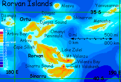
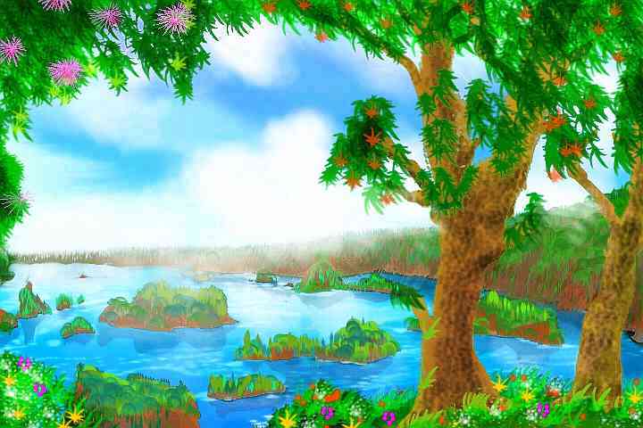
Rorvan Islands
by Chris Wayan, 2006
dedicated to Poul Anderson for his remarkable world-building
Lyr (home) - map - creatures - cultures - evolution - climate - geology - gazetteer - nomenclature - definitions - building Lyr - more worlds? Planetocopia!
GETTING THERE
New to Lyr? First-time orientation--strongly advised! Lyr is weird.
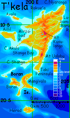
You set out for the Rorvan Archipelago from Mangivolo, the long island at the southern tip of the Diomedes Region of Lyr. I don't mean to be dictatorial--there just are no other flyways in. Well, there's a dangerous 1800-km flight over deep water from Ak'hai'i in the east; but that archipelago's just as isolated. If you must risk that flyway, it'll be outbound, to reach Ak'hai'i. Not a lot of options in this part of the world; these are dead-end tours to lonely lands outside the network of flyways linking most of the planet.
So over the next two days you ride the updrafts down Mangivolo's long spine (this island is nearly as big as Cuba), then south 750 km through the lesser Boran Isles to Herod, a rather Mediterranean land 380 km (240 mi) across. Even from Herod, already an outlier 1000 miles south of the Diomedes Cluster's more civilized lands, you face nearly a week more of steady island-hopping south to reach the Rorvans.
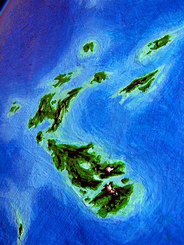
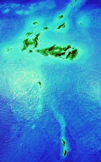
All of this is off this orbital photo of Rorvan itself, at left--I just want to give you some sense of the biological and cultural isolation of the Rorvan group. As lonely as Hawaii--but far bigger.
How big? Lyr's world map shows the Rorvans as mere specks, but that's deceptive--Lyr is huge. The Rorvans total some 800,000 sq km (300,000 sq mi). Nearly three Britains! Rorvan proper is 1100 km (700 mi) long and makes up half that total; Ortu and Sinarru are the other two giants. The climate is mild, especially in the north, and quite wet; temperate rainforest covers most islands. Appalachia, before the great woods were cut for plantations?
Or perhaps, given the volcanoes here, medieval Japan...
You make first landfall in the Rorvan Archipelago at the east end, on Yanvusarran, an island 260 km (160 mi) long, and half as wide. Yanvusarran's wooded, mild and very rainy--a cool-subtropical jungle, really. The coast is ragged, all rocky capes and kelp coves. Think of it as a warmer Oregon, carved out of America's flank and dragged west, far into the Pacific.
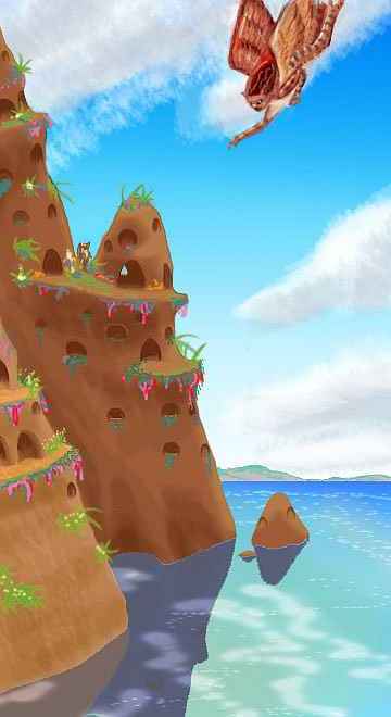
You stay the night in a guest room carved out of a sea-stack, in an icarus eyrie. Your hosts look like smallish angels with feline heads and striped fur. They're just as tactile as cats, too--icari love to be petted. Just be aware they pet back! That's not a warning--you could do worse than a traveler's fling with an icarus, though they do insist on being on top in bed all the time--understandable, with their wingfeathers and hollow bones.
Well, whenever you can tear yourself away from the icari, we'll head on south. From Yanvusarran's southeastern tip, you hop due south over a couple of islets, than an hour over deep water. Slowly the water pales again and the ridges of Menusha rise to the south.
Menusha is narrow--fully 400 km (250 mi) long but only 50-100 wide. The island's long, parallel east-west ridges are all densely wooded, just a corrugated green mass; the climate's just as wet as Yanvusarran.
After a good sleep and some fruit-picking (icari practice silviculture--why clear trees when you can harvest your crops from the tops of them?), and maybe some more sleep, it's time to choose: fly east into the Ak'hai'i Region? Or west toward the heart of Rorvan?
EAST TO AK'HAI'I?
You spend all day flying 600 km (380 mi) east-southeast from Menusha's eastern tip, finding a lone islet in the deep sea at dusk. You rest here for a full day, swimming, sleeping extra hours. And then... no more delays. It's time to face the big jump to Ak'hai'i. A day and a night and a day again, on the wing over deep water, with no rest: 1800 km. Dangerous, but there's just no other way. You set out east across the Rorvan Sea...
WEST INTO RORVAN!
Well! You've decided to be sensible. Good. Let's relax, then. It's a 4-5 hour flight west-northwest to Shinarran, depending on the winds. Shinarran's a wet green hilly island 120 km (80 mi) long--a bit like Puerto Rico, though lower, and the uplands are cooler.
We won't detour to Alasvu, the northernmost of the Rorvans, and a near-twin to Shinarran, though much flatter--less scenic, to my mind. And quite out of our way.
Instead, it's three hours west to Djugaz, a low but rugged and ragged island about 230 km (140 mi) long, with a halo of small islets, it's the northern wall sheltering Djugaz Sound, a shallow gulf about 400 km wide between Ortu, Omanyi and Djugaz.
The shores and isles of Djugaz Sound are all broadleaf temperate rainforest. Flowering trees cling to crags above coves full of iridescent kelp. Lovely scenery...
Either way, two days later you'll end up on...
RORVAN ISLAND

You make landfall on Cape Silish, the northern tip of Rorvan, a bulge 120 km (80 mi) across, built up by two low shield volcanoes. Gentle, pretty country, mostly covered by orchards.
In the morning you skirt Silish Bay and pass from Cape Silish to the Rorvan mainland. A temperate island the size of Japan, 1100 km (700 mi) long, Rorvan's not as drenched as Yanvusarran--it's south of the rainbelt's heart--but it's still lush. Coastal ranges surround a low central plain, so most of Rorvan drains inward to Lake Zulei. The hills are low but rugged, with steep ridges dissected by heavy erosion. Even the fringe of the rainbelt scours and sculpts the land.
Southeast half a day over low coastal hills and inland plains to Lake Zulei, a steely oval 160 km (100 mi) in the center of Rorvan, and draining much of the island. Looks like scuffed aluminum, cloud-shadowed, cloud-dappled.
This is all icarus country; they settled Rorvan around 600 years ago. Those are Lyran years--make that 1500 Earth years! The land is too rainy for antel and a bit too cool for lebbirds, though you'll find some villages in the north; they're recent settlers. Koreens might like it, but they're small, short-distance fliers; perhaps they'll follow your flyway in someday, but don't wait up for them--they'll be risking their lives with every hop. Tauraffes would do well here too, but these huge flightless people can't sail this far on their crude rafts; they're still struggling to fully settle their home cluster. A few sphinx families have made it here from Carnoi, but no one else.
In sum, due to its isolation, Rorvan's one of the least diverse lands on Lyr. In most places, Icari make up over 80% and often over 90% of the population. So you stay in icarus eyries. Not that you mind that--they're scenic, and icari are delightful people--but there's no one else.
If you've toured other regions of Lyr, I'll be that by now this feels unnatural. Congratulations! You're becoming Lyran--you're feeling the sheer hunger for otherness that locals call "out-longing," though it might just as easily be translated "species deprivation." Of course, your newfound sensitivity could become a disadvantage back on Earth. What a lonely world! Billions of people, but all one species. A terrifying monotony! How to they stand it without going crazy? Oh, wait. Do they stand it without going crazy? And who is this they? Don't you mean we?
But that's why this has been a swift, desultory tour. I haven't focused on the people--they're strangely, even disappointingly familiar. They're so human! Not in appearance or genetic heritage, but in their isolation. Just icari and their land--Lyr's rich polyphony dwindled to a thin duet. Some young icari emigrate, even to the dusty rusty lands of the drybelt to the north, simply because they can meet other intelligent species there, and live in a normal Lyran culture full of variety--and different viewpoints.
Your last day on Rorvan, though, the land is enough. Splendor! You reach Sinarru Sound, a winding channel between Rorvan and Sinarru to the south. This saltwater channel is 600 km long and averages 100 wide (400 by 60 mi). It's a spectacular inland passage with steep green craggy walls up to 2 km high, trailing long cloud-banners like scarves. You head east along the passage toward its apparent head, a spectacular, flawless cone like Fuji rising 3300 m (11,000') from the sea, forming its own peninsula. Mt Valakesh nearly links Rorvan and Sinarru into one huge land, but as you approach, a channel opens on the north side. Here, on the Rorvan shore, stands a twin of Valakesh, Mt Volanzu, 3400 meters tall (11,200'), looming over the Sound--the tallest thing in at least 5000 miles.
Naturally, we have to climb it.

Reckless and unnecessary, yes (can you spell T-O-U-R-I-S-T?) but I'll at least show you the easy route up. The prevailing winds here are from the east; so let's flap on through the great gate, upwind of Volanzu, before turning inland and up that endless slope. Here the wind's forced up, and you ride it on and on, up past jungle, cloudforest, fern-alps, lichen-lurid rocky fells, and snowfields, cold and breathless as the day wanes and Lyr's quick sun reddens to the west. You're mostly in blue shadow now, on this eastern face. It becomes a race, but you win--just barely. Over the summit and wheel back, fluttering in the fierce wind like a moth, your wings suddenly flaming in a low magenta spotlight.
Lyr's huge size and low curvature makes the horizon distant indeed from such a height--behind us you can see nearly all of Rorvan right back to the hills of Cape Silish, 450 km away. Pools of shadow and peaks of flame! Ahead, you can see the whole width of Sinarru, and even a line of silverblue sea beyond. Pretty, but ominous... for beyond Sinarru, there's absolutely nothing on the horizon.
And the truth is, a mountaintop's not enough--you could be in low orbit and still not spy land beyond! 3000 km of empty ocean stretches every direction but north where you came from. Rorvan's truly a dead end. To go on, you have to fly all the way back to Menusha and east to Akhai'i, or even further back, to Mangivolo, gateway to Diomedes.
UNKNOWN SEAS
Okay... confession time. I was making a dramatic point, but I stretched the truth. If you were reckless enough to fly a thousand miles west-by-south from Sinarru, you might find land--a nameless island 100 km (63 mi) long.
Except that it's cool, rainy and forested, I don't know a thing about the place. I mention it mainly because it's not an island but a type. It has a couple of even larger sisters another thousand miles southwest. All three are nameless because the Lyrans, not being mariners, haven't found them yet. Indeed, I didn't know about them either, until I happened by with a magnifying glass on the altimetry scans. Yet the larger two look bigger than Hawaii! The nearest, though not as big, looks to be in shouting distance of mainland Sinarru. It's not; that's over 1000 km of deep water.
Because Rorvan is such a compact cluster, and so recently settled, its people simply haven't explored the surrounding seas that well. Well, "explored" is the wrong word: no one's been blown that far off course in JUST the right direction, AND gotten lucky enough to spot it (not easy; this is a cloudy zone, and the worst storms are in winter; how many stormblown icari have died on long winter nights, just miles from its haven, never knowing?), AND been able to land, rest, recuperate AND return safely with the news.
Really, it's a matter of luck, and time. Enough deaths, and someone will get lucky.
There are many more such lands the Lyrans have overlooked--the Dahia and Borthu Islands, and tiny Antarctica, and nameless isles in the central and northern Alianora Sea, and the northern Oronesian Sea, and the southwestern Sunward Sea, and one a couple of thousand kilometers north of the Oronesia-Ayan Flyway, one of the busiest on the planet... If they're over a day's flight from known land, and not in or near an obvious chain with heavy air-traffic, they're likely to have been missed.
In a way, this ignorance is a shadow cast by wings. Flight has served Lyrans well, building a cosmopolitan culture with much lower technology than Earth required--but flight has hidden costs, too. And one is spotty (and mostly accidental) exploration of the deep seas.
On the other wing, let's be fair. It's not that Lyrans are lazy. Lyr's seas are seven times the size of Earth's! Using mere starnose-dolphin gossip and silk charts, they've mapped more surface area more accurately than all our probes of the solar system combined. And they did it in person, using their own effort and skill... risking their lives with every flight.

TOUR LYR! The following route snakes around Lyr, covering all major features:
Ythri -- Polesotechnic Chain -- Troisleons -- Roland -- Oronesia -- Gaiila -- Flandry -- Diomedes -- Ak'hai'i -- Averorn
World Dream Bank homepage - Art gallery - New stuff - Introductory sampler, best dreams, best art - On dreamwork - Books
Indexes: Subject - Author - Date - Names - Places - Art media/styles
Titles: A - B - C - D - E - F - G - H - IJ - KL - M - NO - PQ - R - Sa-Sk - Sl-Sz - T - UV - WXYZ
Email: wdreamb@yahoo.com - Catalog of art, books, CDs - Behind the Curtain: FAQs, bio, site map - Kindred sites