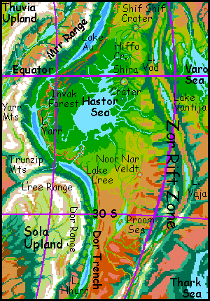
Hastor Basin
by Chris Wayan, 2005-6
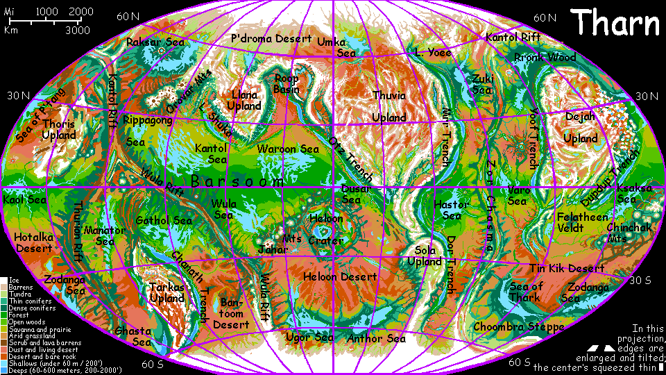
Map, Tharn's homepage, Peoples of Tharn, Regional tours, Geology and Evolution, gazetteer, terms explained. More worlds? Planetocopia!
INTRODUCTION
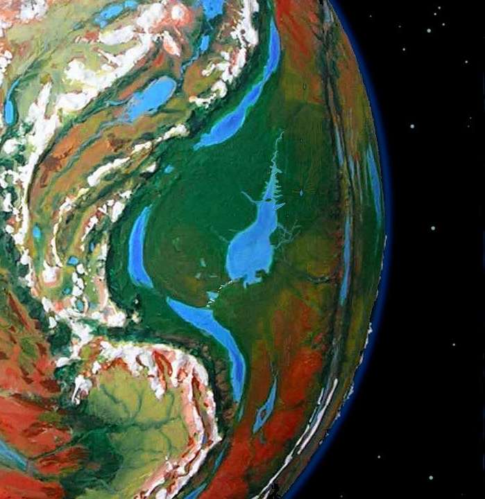
This equatorial plain is one of the greenest and warmest regions of Tharn, quite Terran except for its thin air. The pear-shaped lake in its center is the Hastor Sea, 900 km long (560 mi), and half as wide.
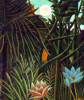
The south shore of Hastor is mostly savanna, but the northern and equatorial shores are rainforest. True, the word means something drier on Tharn than on Earth. Invak Forest, the heart of the rainbelt, gets up to 1.5 m/yr of rain (60") a year--but equivalence is hard to determine, since the year's shorter and evaporation's faster in the thin air. Soil moisture's roughly like a Terran forest getting 1200 mm of annual rain (48 inches).
But Invak Wood is a true rainforest, for it has no dry season, and its plants (like all good Tharnians) are thrifty with water; to them, this much rain is a bonanza. Invak Forest's as lush as New Guinea--and as wide.
 In height, however, Invak more closely resembles California's redwoods: in the low gravity and relatively mild equatorial winds, trees climb wildly toward the sky, routinely topping 120 m (400').
Invak is bo country. These semi-arboreal folk are as close as Tharn gets to apes--and that's not very. More ground-dwelling than any Terran hominid but one--humans--bos look less likely than jackalopes: an absurd mix of cow, velociraptor, kangaroo, ape/human and bear-traits, with scales, mammalian skin, and patchy fur. Good thing they're natural clowns...
OBARA FALLS AND THE TRENCHLAKES
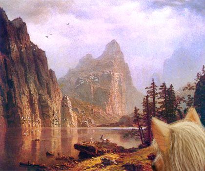
Hastor is a freshwater sea, for it has an outlet: the Obara River, draining the sea down into Lake L'ree in Dor Trench. The river's a chain of great cataracts, over a dozen major ones, many of them spectacular.
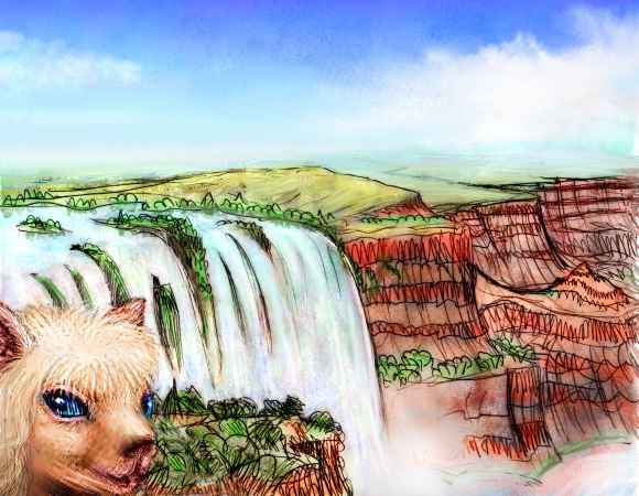 The highest is nearly a kilometer (3200') and 1.6 km wide (a mile), and several more are sheer drops of 600 m or more (2000'+), for the Obara drops 3500 m (11,500') in only 100 km (65 mi). Nor are these mere plumes like Angel or Yosemite Falls; the flow is larger than Niagara! The Hastor Basin may not be the Amazon, but it's still rainy.
It's an ecologically dangerous situation, for if the flow increased much it could fill the trench, destroying the falls and creating a birdsea sequestering much of Tharn's water. Three things prevented this: Hastor, though rainy, is still a Tharnian bedlake, with an air pressure only a quarter that on Earth's surface; evaporation is swift. Lake L'ree is much lower, but hotter, too, and in a sunny, high-evaporation zone. And L'ree has a safety valve; it spills over into Lake Hhurr to the south, in a hot dry zone. The three lakes and their long linking rivers manage to evaporate as much water as the rainfall they collect. Still, the falls have filled L'ree to an average of 400 meters, unusually deep for the Dor/Mrr Trench system. And even 3.5 km down is a high tide of sorts: 4-6 km down is more typical of Mrr Trench.
A similar situation exists due west of Hastor, without any falls at all. Though Invak Wood's plain ends in low hills near Yarr Trench, preventing any great rivers from draining down into the trench, Lake Yarr in its depths is a mere 2.5 km (8000') down, due to high rainfall.
Though small in area, Lake Yarr too is nearly a km deep in spots, and 300 m on average. Since it stretches from 5-13 degrees south and the (relatively) thick air holds heat and moisture, the climate's quite steamy. The slopes of the trench are a hot rainforest lusher and stranger than Invak Wood.

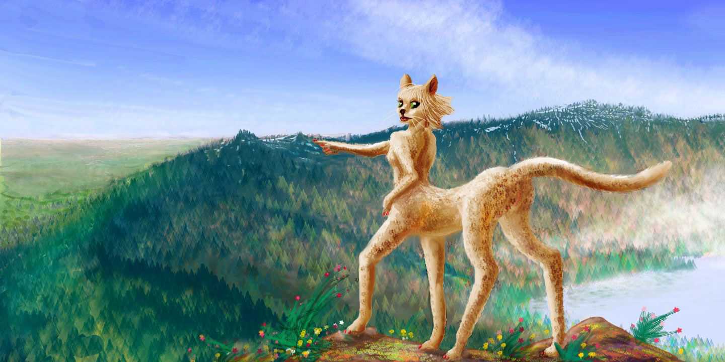
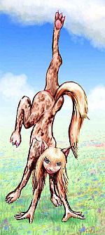
Still, air pressure is relative. While the bos of Invak Wood find Lake Yarr a high-pressure steambath, air a mere 8000' down is relatively thin for the native lebbirds; their species evolved around trenchlakes 3-6 km (10-20,000') below the plains! The combination of equatorial heat and comparatively thin air around Lake Yarr has made the Yarran lebbirds small, slender and long-limbed, with short pelts and big foxlike ears to help radiate heat, like Saharan cats and foxes; and the lower weight eases flight in the thin air.
The sketch at right shows the difference; though she's a full-grown adult, this Yarran looks like a jaunty little kitten compared to the formidable, leonine, sphinxlike people of the north.
To the west of the lake and trench is another world--the Yarr Mountains, the gigantic front range of Molak Upland. The Yarrs are as high as the Andes, 5-7 km (16-23,000'), but much taller--up to 9500 m (31,500') tall as seen from the trench floor--taller than the Himalayas, in fact. The treeline is much higher, since they're equatorial, but the Yarrs are still ice-crowned--and steeper, due to Tharn's low gravity.
Cliffs rivaling Yosemite's loom over deep hanging valleys and lakes... except these cliffs gleam with little round windows and doors--whole cliff-palaces full of flyotes and lebbirds. A spectacular sight no tourist should miss!
HASTOR'S COAST
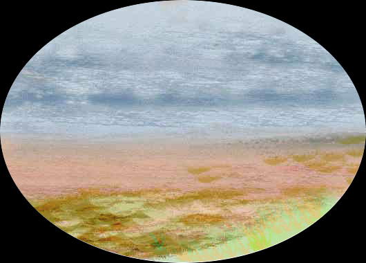
The Hastor Basin has a quieter beauty: its wealth is water. And warmth. It's not in a trench, but it straddles the equator, and the rising, sun-warmed air generates thunderstorms: generous rains, for Tharn. Hastor Sea may be shallow, but it's no typical Tharnian water-maze or glorified marsh. It's a broad unbroken sheet of water with a clear coastline and few islands--or rather, few obvious ones.
There are some crypto-islands. The winding channels of the Hastor Delta on the southeast coast cut off large curved swatches of jungle; the delta looks like a huge jigsaw puzzle. In some cases mere yards divide these "islands" from the mainland forest. Trees here are so big that their branches nearly meet mid-stream; ground-dwellers can swim or wade across, and in the low gravity, arboreal creatures can often swing or leap across. So speciation's been less than in Terran rainforests, where rivers can be impassable barriers for nonfliers--chimps, bonobos and western chimps probably speciated due to uncrossable rivers (those big scaly toothy things in the rivers had much to do with it too).
Tharn's only flightless arboreal people, bos, are certainly not at risk of speciating here--they learned how to raft early on, from thotters. In fact, though bos live in scattered forests around the equator, they're much the same worldwide, for they travel readily and can breathe the thin air of high passes, unlike the two other arboreals, arthom and lebbirds.
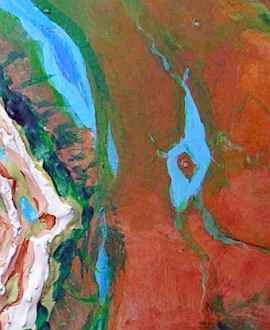
Hastor's most peculiar feature is a set of "fjords" at the north end. It seems as if the sea flooded a stretch of washboard terrain. But a close inspection under the canopy reveals that these ridges and valleys aren't parallel but radial--centered on Lake Shira, straddling the equator 300 km/190 mi east of the sea. Why? Climb the wall and look! It's worth it.
Lake Shira is the flooded floor of an impact crater over 80 km wide (50 mi). Rays of ejected rock from Shira shirr the shore (sorry, I couldn't resist), forming regular capes and bays for several hundred kilometers. Shira Island, well offshore in the Hastor Sea, is full of unique species, though none have developed intelligence; the local population is thotters and bos, same as the mainland.
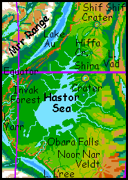
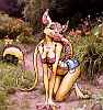
300 km north, Hiffa Crater rises from the forest. It's smaller, only 40 km wide (25 mi); the ringwall is just 500 m high (1600'). Hiffa roughly marks the edge of the true rainforest--to the north the woods open into groves and strips along the winding rivers. Villages are mixed, with fewer bos and more savanna folk like centahs and veltaurs (right).
A third crater, Shif Shif, is nearly as big as Shira, some 70 km wide (45 mi) across. It lies in true veldt, about 500 km past Hiffa. This savanna, often called Shif Shif Veldt, stretches north hundreds of km more, gradually fading into the Zu Desert.
This close to Zor Rift, all the crust is new--no more than 12 million years old. Thus, these impacts must be even more recent. And there are more: a whole chain of craters stretches from 25 south to 30 north. They were almost certainly formed together from the impact of a comet train like Shoemaker-Levy.
NOOR NAR VELDT
East and south of Invak Wood, the trees fray into groves dotting a huge golden savanna settled mostly by veltaurs. This is Noor Nar Veldt, the size of Texas; green in winter, gold in summer, inhabited by a mixture of veltaurs, centahs and flyotes. The only hills are the walls and rays of Noor Nar Crater. The crater, 25 km across (15 mi), is another fresh scar no more than 10 million years old, with a ringwall still nearly a kilometer high--high enough to catch rain and sustain forests. The floor is a round lake, one of the few in the region; small streams radiate out from the debris apron.
South of the crater, the veldt slowly fades into an endless red plain: the Proom Desert, 1000 km wide and several thousand long. If this were Earth, it'd be the Proom Ocean. But this is Tharn, and so...
ZOR CHASMA
This rift valley stretches nearly pole to pole. The ridges flanking Zor Rift are relatively gentle, and not high enough to form a migration barrier to most species. But the rift valley itself is another matter. The ridges cut off rains from the Hastor and Varo Seas, so the central chasma is drier, ranging from savanna at the equator to a desert strip around 30 north and south. Savanna dwellers cross readily, but rainforest creatures in the Hastor and Varo Basins tend to differ.
Zor Chasma is dotted with long, narrow riftlakes, like our Lake Tanganyika and Lake Malawi. The largest is Lake Vantija, from 3-12 south. Fully 800 km long and up to 100 wide (500 by 65 mi), Vantija's brackish, mineralized, and home to unique fauna--giant five-legged "crabs". Some species crawl onto land, though they return to the lake to reproduce. Evolution continues! In a way, Vantija is a time-capsule: Tharnian life probably first crept onto the land from a lake much like this, though Vantija itself is far too young to be the source.
Lake Vad, half as big, lies just north of the equator, near Hiffa Crater. Instead of crabs, its dominant fauna are multipedes, bottom crawlers up to 1.5 m long (5'). With their spines, legs and feelers, they look a bit like lobster-centipede hybrids--or scaled-up Hallucinaria fossils from the Cambrian. The isolation of these many riftlakes and their differing compositions has aided the survival and ongoing development of evolutionary experiments that would die out in Earth's huge, single, competitive world-ocean.
World Dream Bank homepage - Art gallery - New stuff - Introductory sampler, best dreams, best art - On dreamwork - Books
Indexes: Subject - Author - Date - Names - Places - Art media/styles
Titles: A - B - C - D - E - F - G - H - IJ - KL - M - NO - PQ - R - Sa-Sk - Sl-Sz - T - UV - WXYZ
Email: wdreamb@yahoo.com - Catalog of art, books, CDs - Behind the Curtain: FAQs, bio, site map - Kindred sites